Rover visualization and other apps, For discussions of ways to view and understand the mission |

Rover visualization and other apps, For discussions of ways to view and understand the mission |
 Apr 8 2021, 06:25 AM Apr 8 2021, 06:25 AM
Post
#1
|
|
|
Solar System Cartographer  Group: Members Posts: 10226 Joined: 5-April 05 From: Canada Member No.: 227 |
Hi Everyone. I am starting a thread for discussions of the many ways people are interacting with Perseverance (and potentially other missions). These subjects are getting spread around other threads and maybe getting in the way of basic mission updates etc., so this is a place to bring this together. Feel free to contribute to it.
I am going to start by asking about panoramas - what's the best way to do this with Perseverance images, especially Navcam images from every end of drive? Phil -------------------- ... because the Solar System ain't gonna map itself.
Also to be found posting similar content on https://mastodon.social/@PhilStooke Maps for download (free PDF: https://upload.wikimedia.org/wikipedia/comm...Cartography.pdf NOTE: everything created by me which I post on UMSF is considered to be in the public domain (NOT CC, public domain) |
 |
 
|
 |
|
Apr 9 2021, 06:07 AM
Post
#2
|
|||||
 Newbie Group: Members Posts: 16 Joined: 1-April 21 From: La Crescenta, CA Member No.: 9001 |
Hi all,
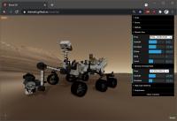
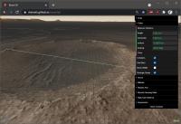
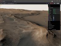
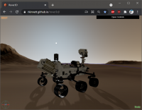
Wanted to introduce you to (yet another) rover and terrain visualization web app which I hope will help folks become familiar with Perseverance and the Jezero Delta. My Rover3D page mimics actual MER and MSL driving tools. The Perseverance rover model derives from the official JPL public release model, but has been heavily modified to finish incomplete texture and material mapping, and has been split into articulable parts which you can control via sliders, similar to the official rover driving tools. Or you can send the arm, RSM, and HGA to one of several selectable canonical poses, matching MSL's standard defined poses (note: the default arm pose in the public release model, with upper arm horizontal and forearm vertical, is non-standard and not generally used). The Jezero Delta front-range terrain is composed of a HiRISE ortho-rectified luminance image (downscaled to 50cm/px for performance), blended with one of Justin Cowart's masterpiece CRISM color mosaics, and draped over a MOLA DTM. Click "ABOUT" in the upper-left corner for general information, controls, and credits. The controls take a minute to get used to, but are optimized to help you scoot around the scene quickly and freely. Quick synopsis:
Explore the northern Delta approach strategic route (cyan), southern approach route (blue), and the delta entry route (yellow)! Planned future work:
Screenshots:
I hope you find this useful! |
||||
|
|
|
||||
 Phil Stooke Rover visualization and other apps Apr 8 2021, 06:25 AM
 vikingmars QUOTE (Phil Stooke @ Apr 8 2021, 08:25 AM... Apr 9 2021, 04:34 AM
 Art Martin QUOTE (Ryan Kinnett @ Apr 8 2021, 11:07 P... Apr 9 2021, 04:56 PM ChrisC QUOTE (Art Martin @ Apr 9 2021, 12:56 PM)... Apr 10 2021, 07:55 PM Andreas Plesch Very nice 3D scene ! I think the larger scale ... Apr 9 2021, 07:53 AM Ryan Kinnett QUOTE (Andreas Plesch @ Apr 8 2021, 11:53... Apr 9 2021, 04:41 PM Andreas Plesch QUOTE (Ryan Kinnett @ Apr 9 2021, 12:41 P... Apr 10 2021, 11:01 PM Ryan Kinnett Thanks guys for testing. Ive got it crashing in F... Apr 10 2021, 09:36 PM Phil Stooke Hi Ryan - don't worry. What I was really doin... Apr 11 2021, 01:35 AM Ryan Kinnett I may have fixed the firefox loading issue. At le... Apr 11 2021, 07:55 AM Andreas Plesch QUOTE (Ryan Kinnett @ Apr 11 2021, 03:55 ... Apr 11 2021, 05:34 PM vikingmars QUOTE (Phil Stooke @ Apr 8 2021, 08:25 AM... Apr 11 2021, 10:14 AM Ant103 QUOTE (vikingmars @ Apr 11 2021, 12:14 PM... Apr 12 2021, 09:33 AM phase4 QUOTE (Ant103 @ Apr 12 2021, 11:33 AM) Wh... Apr 12 2021, 11:50 PM mcaplinger QUOTE (Ant103 @ Apr 12 2021, 01:33 AM) Wh... Apr 13 2021, 12:52 AM stevesliva QUOTE (mcaplinger @ Apr 12 2021, 07:52 PM... Apr 13 2021, 02:20 PM vikingmars QUOTE (Ant103 @ Apr 12 2021, 11:33 AM) Fo... Apr 13 2021, 08:44 AM Andreas Plesch Here is an overview of https://bit.ly/PercyMAP
Pe... Apr 12 2021, 11:45 AM phase4 Hey all, i'm the person responsible for the el... Apr 12 2021, 12:32 PM ChrisC QUOTE (phase4 @ Apr 12 2021, 07:32 AM) He... Apr 28 2021, 02:58 AM Andreas Plesch https://bit.ly/PercyMAP updated to rely less on co... Apr 12 2021, 01:23 PM Ant103 QUOTE but WATSON raw color is exactly the same as ... Apr 13 2021, 08:09 AM Andreas Plesch https://bit.ly/PercyMAP was updated since after th... Apr 14 2021, 05:19 AM Andreas Plesch https://bit.ly/PercyMAP was updated with an approx... Apr 19 2021, 10:23 PM Ryan Kinnett QUOTE (Andreas Plesch @ Apr 19 2021, 02:2... Apr 20 2021, 03:15 AM Andreas Plesch Thanks. There is a web API, for example https://wg... Apr 20 2021, 04:03 AM Andreas Plesch Update to https://bit.ly/PercyMAP to include a rot... Apr 20 2021, 06:44 PM Andreas Plesch Further update to https://bit.ly/PercyMAP :
- app... Apr 26 2021, 04:00 AM Andreas Plesch Latest drive introduced null (?) geometries in tra... Apr 27 2021, 01:35 PM Andreas Plesch https://bit.ly/PercyMAP updated to latest drive, a... Apr 28 2021, 02:12 AM Andreas Plesch https://bit.ly/PercyMAP updated to latest drive; t... May 4 2021, 03:47 AM Andreas Plesch https://bit.ly/PercyMAP updated to include approxi... May 8 2021, 04:37 AM Andreas Plesch Minor updates to https://bit.ly/PercyMAP : improve... May 15 2021, 03:14 AM Andreas Plesch https://bit.ly/PercyMAP updated to work with lates... May 16 2021, 07:10 PM Greenish The RMC has a Site counter that updates each time ... May 16 2021, 09:08 PM Andreas Plesch QUOTE (Greenish @ May 16 2021, 04:08 PM) ... May 16 2021, 09:18 PM djellison QUOTE (Andreas Plesch @ May 16 2021, 02:1... May 16 2021, 11:54 PM Andreas Plesch QUOTE (djellison @ May 16 2021, 07:54 PM)... May 17 2021, 01:53 AM Andreas Plesch In anticipation of flight 6, I updated https://bit... May 23 2021, 01:17 AM Andreas Plesch QUOTE (Andreas Plesch @ May 22 2021, 09:1... Jun 13 2021, 01:17 AM Andreas Plesch Here is a quick bookmarklet to extract the Urls of... May 29 2021, 03:46 AM Ryan Kinnett If you have a VR headset (ideally Oculus Quest), c... Jun 13 2021, 07:44 AM PaulH51 Has anyone here found an App or utility for range ... Jun 16 2021, 06:10 AM neo56 For those who would be interested, I have coded in... Jun 25 2021, 01:50 PM
Art Martin QUOTE (Ryan Kinnett @ Apr 8 2021, 11:07 P... Apr 9 2021, 04:56 PM ChrisC QUOTE (Art Martin @ Apr 9 2021, 12:56 PM)... Apr 10 2021, 07:55 PM Andreas Plesch Very nice 3D scene ! I think the larger scale ... Apr 9 2021, 07:53 AM Ryan Kinnett QUOTE (Andreas Plesch @ Apr 8 2021, 11:53... Apr 9 2021, 04:41 PM Andreas Plesch QUOTE (Ryan Kinnett @ Apr 9 2021, 12:41 P... Apr 10 2021, 11:01 PM Ryan Kinnett Thanks guys for testing. Ive got it crashing in F... Apr 10 2021, 09:36 PM Phil Stooke Hi Ryan - don't worry. What I was really doin... Apr 11 2021, 01:35 AM Ryan Kinnett I may have fixed the firefox loading issue. At le... Apr 11 2021, 07:55 AM Andreas Plesch QUOTE (Ryan Kinnett @ Apr 11 2021, 03:55 ... Apr 11 2021, 05:34 PM vikingmars QUOTE (Phil Stooke @ Apr 8 2021, 08:25 AM... Apr 11 2021, 10:14 AM Ant103 QUOTE (vikingmars @ Apr 11 2021, 12:14 PM... Apr 12 2021, 09:33 AM phase4 QUOTE (Ant103 @ Apr 12 2021, 11:33 AM) Wh... Apr 12 2021, 11:50 PM mcaplinger QUOTE (Ant103 @ Apr 12 2021, 01:33 AM) Wh... Apr 13 2021, 12:52 AM stevesliva QUOTE (mcaplinger @ Apr 12 2021, 07:52 PM... Apr 13 2021, 02:20 PM vikingmars QUOTE (Ant103 @ Apr 12 2021, 11:33 AM) Fo... Apr 13 2021, 08:44 AM Andreas Plesch Here is an overview of https://bit.ly/PercyMAP
Pe... Apr 12 2021, 11:45 AM phase4 Hey all, i'm the person responsible for the el... Apr 12 2021, 12:32 PM ChrisC QUOTE (phase4 @ Apr 12 2021, 07:32 AM) He... Apr 28 2021, 02:58 AM Andreas Plesch https://bit.ly/PercyMAP updated to rely less on co... Apr 12 2021, 01:23 PM Ant103 QUOTE but WATSON raw color is exactly the same as ... Apr 13 2021, 08:09 AM Andreas Plesch https://bit.ly/PercyMAP was updated since after th... Apr 14 2021, 05:19 AM Andreas Plesch https://bit.ly/PercyMAP was updated with an approx... Apr 19 2021, 10:23 PM Ryan Kinnett QUOTE (Andreas Plesch @ Apr 19 2021, 02:2... Apr 20 2021, 03:15 AM Andreas Plesch Thanks. There is a web API, for example https://wg... Apr 20 2021, 04:03 AM Andreas Plesch Update to https://bit.ly/PercyMAP to include a rot... Apr 20 2021, 06:44 PM Andreas Plesch Further update to https://bit.ly/PercyMAP :
- app... Apr 26 2021, 04:00 AM Andreas Plesch Latest drive introduced null (?) geometries in tra... Apr 27 2021, 01:35 PM Andreas Plesch https://bit.ly/PercyMAP updated to latest drive, a... Apr 28 2021, 02:12 AM Andreas Plesch https://bit.ly/PercyMAP updated to latest drive; t... May 4 2021, 03:47 AM Andreas Plesch https://bit.ly/PercyMAP updated to include approxi... May 8 2021, 04:37 AM Andreas Plesch Minor updates to https://bit.ly/PercyMAP : improve... May 15 2021, 03:14 AM Andreas Plesch https://bit.ly/PercyMAP updated to work with lates... May 16 2021, 07:10 PM Greenish The RMC has a Site counter that updates each time ... May 16 2021, 09:08 PM Andreas Plesch QUOTE (Greenish @ May 16 2021, 04:08 PM) ... May 16 2021, 09:18 PM djellison QUOTE (Andreas Plesch @ May 16 2021, 02:1... May 16 2021, 11:54 PM Andreas Plesch QUOTE (djellison @ May 16 2021, 07:54 PM)... May 17 2021, 01:53 AM Andreas Plesch In anticipation of flight 6, I updated https://bit... May 23 2021, 01:17 AM Andreas Plesch QUOTE (Andreas Plesch @ May 22 2021, 09:1... Jun 13 2021, 01:17 AM Andreas Plesch Here is a quick bookmarklet to extract the Urls of... May 29 2021, 03:46 AM Ryan Kinnett If you have a VR headset (ideally Oculus Quest), c... Jun 13 2021, 07:44 AM PaulH51 Has anyone here found an App or utility for range ... Jun 16 2021, 06:10 AM neo56 For those who would be interested, I have coded in... Jun 25 2021, 01:50 PM |

|
Lo-Fi Version | Time is now: 21st September 2024 - 02:25 PM |
|
RULES AND GUIDELINES Please read the Forum Rules and Guidelines before posting. IMAGE COPYRIGHT |
OPINIONS AND MODERATION Opinions expressed on UnmannedSpaceflight.com are those of the individual posters and do not necessarily reflect the opinions of UnmannedSpaceflight.com or The Planetary Society. The all-volunteer UnmannedSpaceflight.com moderation team is wholly independent of The Planetary Society. The Planetary Society has no influence over decisions made by the UnmannedSpaceflight.com moderators. |
SUPPORT THE FORUM Unmannedspaceflight.com is funded by the Planetary Society. Please consider supporting our work and many other projects by donating to the Society or becoming a member. |
|