MARCI Images, ISIS pointers/advice/help much appreciated and desired! |

MARCI Images, ISIS pointers/advice/help much appreciated and desired! |
 Aug 18 2010, 07:51 PM Aug 18 2010, 07:51 PM
Post
#1
|
||
|
Member  Group: Members Posts: 293 Joined: 29-August 06 From: Columbia, MD Member No.: 1083 |
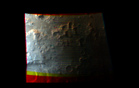
As part of my research, I'm starting to learn ISIS and display MARCI imagery. I've quickly learned that MARCI imagery is pretty hard to work with since it's a push-frame camera, which a few people claim is the reason there's a relative lack of papers published using its data. I tried to run through the process for an entire pole-to-pole MARCI swath and after processing cam2map for nearly 48hrs, the Linux box booted me off. That's on 8GB of RAM, BTW. After that, I started cropping the images to much smaller chunks. Below is my first recognizably Martian image that I've been able to produce (I've only been at this for a few days). This is from the southern mid-latitude highlands. Some things I don't understand...why is the left part of the frame somewhat washed out/bright? The red/yellow bands around the edge are areas where there apparently is no data in the green or blue channels...not sure why. My processing steps are:
marci2isis spiceinit marcical crop cam2map automos I need to figure out how to really speed this up. I want to look at complete MARCI global mosaics over at least 1 martian year if not the entire MRO mission. At this rate, that would take years  . Apparently an ISIS update is coming out in the near future which will help work with LROC WAC images. LROC WAC is also pushframe, so maybe that will help with MARCI imagery as well? . Apparently an ISIS update is coming out in the near future which will help work with LROC WAC images. LROC WAC is also pushframe, so maybe that will help with MARCI imagery as well? Thanks in advance!
Attached thumbnail(s)
|
|
 |
 
|
|
 |
|
Jun 1 2021, 12:51 AM
Post
#2
|
|
|
Member Group: Members Posts: 306 Joined: 4-October 14 Member No.: 7273 |
Continuing to work with MARCI data, now rendering videos at real-time orbital speed. This orbit captures some dust storms along the southern edge of Claritas Fossae, nice albedo markings in Syria Planum, a handful of the Tharsis Montes, and the northern polar cap lit by the midnight sun.
https://www.youtube.com/watch?v=koNXF6myc5Q |
|
|
|
|
Jun 1 2021, 05:09 PM
Post
#3
|
|
 Senior Member Group: Members Posts: 1089 Joined: 19-February 05 From: Close to Meudon Observatory in France Member No.: 172 |
QUOTE (jccwrt @ Jun 1 2021, 02:51 AM)  Continuing to work with MARCI data, now rendering videos at real-time orbital speed. This orbit captures some dust storms along the southern edge of Claritas Fossae, nice albedo markings in Syria Planum, a handful of the Tharsis Montes, and the northern polar cap lit by the midnight sun. This is an ASTOUNDING movie ! Thanks so much Jccwrt for sharing this work with us   |
|
|
|
 Drkskywxlt MARCI Images Aug 18 2010, 07:51 PM
 Drkskywxlt Using a MARCI swath from a later orbit (6124), I m... Aug 24 2010, 02:44 PM Drkskywxlt I never posted some of the other (slightly more in... Jul 27 2012, 05:43 PM Drkskywxlt .
. Jul 27 2012, 05:45 PM mhoward Very nice. First one in that pair shows Tempe Terr... Jul 27 2012, 05:52 PM Drkskywxlt Yes, I split a larger image into two pieces. Comb... Jul 27 2012, 06:19 PM jccwrt I've decided to take up working with MARCI ima... Dec 26 2020, 08:35 PM jccwrt Continuing to refine my process and sharpen my ski... Mar 6 2021, 03:47 AM
Drkskywxlt Using a MARCI swath from a later orbit (6124), I m... Aug 24 2010, 02:44 PM Drkskywxlt I never posted some of the other (slightly more in... Jul 27 2012, 05:43 PM Drkskywxlt .
. Jul 27 2012, 05:45 PM mhoward Very nice. First one in that pair shows Tempe Terr... Jul 27 2012, 05:52 PM Drkskywxlt Yes, I split a larger image into two pieces. Comb... Jul 27 2012, 06:19 PM jccwrt I've decided to take up working with MARCI ima... Dec 26 2020, 08:35 PM jccwrt Continuing to refine my process and sharpen my ski... Mar 6 2021, 03:47 AM jccwrt I rendered out a new video this weekend! This ... Oct 5 2021, 03:32 PM vikingmars QUOTE (jccwrt @ Oct 5 2021, 05:32 PM) I r... Oct 6 2021, 07:21 AM
 |

|
Lo-Fi Version | Time is now: 20th June 2024 - 10:30 PM |
|
RULES AND GUIDELINES Please read the Forum Rules and Guidelines before posting. IMAGE COPYRIGHT |
OPINIONS AND MODERATION Opinions expressed on UnmannedSpaceflight.com are those of the individual posters and do not necessarily reflect the opinions of UnmannedSpaceflight.com or The Planetary Society. The all-volunteer UnmannedSpaceflight.com moderation team is wholly independent of The Planetary Society. The Planetary Society has no influence over decisions made by the UnmannedSpaceflight.com moderators. |
SUPPORT THE FORUM Unmannedspaceflight.com is funded by the Planetary Society. Please consider supporting our work and many other projects by donating to the Society or becoming a member. |
|