Zhurong maps, traverse route and location mapping |

Zhurong maps, traverse route and location mapping |
 May 19 2021, 11:46 PM May 19 2021, 11:46 PM
Post
#1
|
|
|
Solar System Cartographer  Group: Members Posts: 10226 Joined: 5-April 05 From: Canada Member No.: 227 |
I'm starting a map thread. It's hard to know what we will get but I expect a route map will emerge bit by bit. Maps showing the landing location will be easier to make initially.
Phil -------------------- ... because the Solar System ain't gonna map itself.
Also to be found posting similar content on https://mastodon.social/@PhilStooke Maps for download (free PDF: https://upload.wikimedia.org/wikipedia/comm...Cartography.pdf NOTE: everything created by me which I post on UMSF is considered to be in the public domain (NOT CC, public domain) |
 |
 
|
 |
|
Jul 9 2021, 02:27 PM
Post
#2
|
|||||
 Member Group: Members Posts: 185 Joined: 4-January 19 Member No.: 8523 |
And Zhurong is almost at the parachute... Would be nice to get a new Hirise.
Huge image with a recent path nice guess from here: https://twitter.com/TheElegant055/status/1413594702054674432 Link to 50MB full resolution version: https://drive.google.com/drive/folders/19PT...TILuTgwRZE4Mk8E
Attached thumbnail(s)
-------------------- "The Earth is a very small stage in a vast cosmic arena"
|
||||
|
|
|
||||
 Phil Stooke Zhurong maps May 19 2021, 11:46 PM
 Phil Stooke Starting off with an overview of the site, with la... May 22 2021, 05:14 PM Greenish Until higher-res imagery arrives, here's a cro... May 23 2021, 03:55 AM Phil Stooke It's clear that following this mission will be... Jun 10 2021, 07:20 AM Phil Stooke OK, HiRISE image and a new location.
Phil
Jun 10 2021, 08:08 PM Phil Stooke The text accompanying the 'group photo' of... Jun 11 2021, 07:45 AM kymani76 I'm a bit late to the game as I had other work... Jun 12 2021, 11:34 AM kymani76
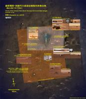
All landed hardware map in HiRise color. Grid at ... Jun 12 2021, 11:38 AM kymani76
Traverse map, based on tracks visible when enhanc... Jun 12 2021, 11:46 AM Phil Stooke After the second HiRISE image appeared I have made... Jun 24 2021, 03:56 AM Phil Stooke Bit by bit a map takes shape. This uses the new p... Jun 27 2021, 07:31 PM Phil Stooke And an overview map - this will be the standard re... Jun 27 2021, 08:25 PM Bill Harris So, those light-toned features are barchan-like d... Jul 9 2021, 08:11 PM Phil Stooke The LIBS instrument will give composition - they w... Jul 9 2021, 09:25 PM Huguet China's Zhurong rover drives for over 410 mete... Jul 11 2021, 03:34 PM Phil Stooke I updated my map with the parachute images. The s... Jul 15 2021, 05:37 PM kymani76
As usual Phil beat me to the update, bur anyway h... Jul 16 2021, 09:07 PM Phil Stooke You are doing some really nice work here - for all... Jul 16 2021, 09:54 PM kymani76 Thanks Phil. Means a lot. In fact you just gave me... Jul 18 2021, 07:43 PM Phil Stooke I just had an interesting and very welcome email f... Jul 19 2021, 06:31 PM Phil Stooke The Chinese map I linked to in the main thread let... Jul 23 2021, 07:13 AM Phil Stooke My best guess for sol 75 would be right at the bot... Jul 31 2021, 07:21 AM kymani76
Tentative sol 75 update. I left the dates out, be... Aug 1 2021, 10:52 AM Hungry4info New drive map from here. Aug 17 2021, 08:30 PM Bill Harris I give them passing marks on autonomous driving (... Aug 19 2021, 05:26 AM ollopa QUOTE (Phil Stooke @ May 22 2021, 07:14 P... Aug 20 2021, 05:15 PM Phil Stooke You are right, it should be more like 30 km betwee... Aug 21 2021, 01:32 AM Hungry4info New drive map from here. Aug 30 2021, 10:29 AM Phil Stooke This map is very useful, but I am intrigued to fin... Aug 30 2021, 05:41 PM Huguet Amazing how detailed the orbiter get the track... ... Aug 31 2021, 12:13 AM Phil Stooke We have had no news on Tianwen-1 and Zhurong for a... Sep 17 2021, 05:45 PM Bill Harris Agreed. The 'quiet spell' from Zhurong is... Sep 18 2021, 01:51 PM Phil Stooke Here is an update to my map (section 2) based on t... Nov 8 2021, 08:09 PM kymani76
Recently new geological map for Zhurong landing s... Dec 24 2021, 09:26 AM kymani76
Sol 174 map update. Dec 24 2021, 09:30 AM Phil Stooke A very quick look at the end of year location. Th... Jan 1 2022, 08:10 AM kymani76
Sol 201 update in IRG color, based on latest ima... Jan 4 2022, 02:23 PM
Phil Stooke Starting off with an overview of the site, with la... May 22 2021, 05:14 PM Greenish Until higher-res imagery arrives, here's a cro... May 23 2021, 03:55 AM Phil Stooke It's clear that following this mission will be... Jun 10 2021, 07:20 AM Phil Stooke OK, HiRISE image and a new location.
Phil
Jun 10 2021, 08:08 PM Phil Stooke The text accompanying the 'group photo' of... Jun 11 2021, 07:45 AM kymani76 I'm a bit late to the game as I had other work... Jun 12 2021, 11:34 AM kymani76
All landed hardware map in HiRise color. Grid at ... Jun 12 2021, 11:38 AM kymani76
Traverse map, based on tracks visible when enhanc... Jun 12 2021, 11:46 AM Phil Stooke After the second HiRISE image appeared I have made... Jun 24 2021, 03:56 AM Phil Stooke Bit by bit a map takes shape. This uses the new p... Jun 27 2021, 07:31 PM Phil Stooke And an overview map - this will be the standard re... Jun 27 2021, 08:25 PM Bill Harris So, those light-toned features are barchan-like d... Jul 9 2021, 08:11 PM Phil Stooke The LIBS instrument will give composition - they w... Jul 9 2021, 09:25 PM Huguet China's Zhurong rover drives for over 410 mete... Jul 11 2021, 03:34 PM Phil Stooke I updated my map with the parachute images. The s... Jul 15 2021, 05:37 PM kymani76
As usual Phil beat me to the update, bur anyway h... Jul 16 2021, 09:07 PM Phil Stooke You are doing some really nice work here - for all... Jul 16 2021, 09:54 PM kymani76 Thanks Phil. Means a lot. In fact you just gave me... Jul 18 2021, 07:43 PM Phil Stooke I just had an interesting and very welcome email f... Jul 19 2021, 06:31 PM Phil Stooke The Chinese map I linked to in the main thread let... Jul 23 2021, 07:13 AM Phil Stooke My best guess for sol 75 would be right at the bot... Jul 31 2021, 07:21 AM kymani76
Tentative sol 75 update. I left the dates out, be... Aug 1 2021, 10:52 AM Hungry4info New drive map from here. Aug 17 2021, 08:30 PM Bill Harris I give them passing marks on autonomous driving (... Aug 19 2021, 05:26 AM ollopa QUOTE (Phil Stooke @ May 22 2021, 07:14 P... Aug 20 2021, 05:15 PM Phil Stooke You are right, it should be more like 30 km betwee... Aug 21 2021, 01:32 AM Hungry4info New drive map from here. Aug 30 2021, 10:29 AM Phil Stooke This map is very useful, but I am intrigued to fin... Aug 30 2021, 05:41 PM Huguet Amazing how detailed the orbiter get the track... ... Aug 31 2021, 12:13 AM Phil Stooke We have had no news on Tianwen-1 and Zhurong for a... Sep 17 2021, 05:45 PM Bill Harris Agreed. The 'quiet spell' from Zhurong is... Sep 18 2021, 01:51 PM Phil Stooke Here is an update to my map (section 2) based on t... Nov 8 2021, 08:09 PM kymani76
Recently new geological map for Zhurong landing s... Dec 24 2021, 09:26 AM kymani76
Sol 174 map update. Dec 24 2021, 09:30 AM Phil Stooke A very quick look at the end of year location. Th... Jan 1 2022, 08:10 AM kymani76
Sol 201 update in IRG color, based on latest ima... Jan 4 2022, 02:23 PM
 Bill Harris QUOTE (kymani76 @ Jan 4 2022, 09:23 AM) a... Jan 5 2022, 02:51 AM kymani76 QUOTE (Bill Harris @ Jan 5 2022, 03:51 AM... Jan 5 2022, 08:03 PM Phil Stooke I assumed the partial panorama was from the end of... Jan 4 2022, 09:22 PM kymani76
Preliminary sol 262 map update, based on this map... Mar 15 2022, 04:34 PM kymani76 Recent article characterizing first 60 sols of Zhu... Mar 22 2022, 12:25 PM kymani76 Zhurong traverse updated with track visible in new... Mar 24 2022, 04:44 PM kymani76
In addition I also made elevation map with the ne... Mar 24 2022, 04:48 PM vikingmars QUOTE (kymani76 @ Mar 24 2022, 05:48 PM) ... Mar 24 2022, 06:28 PM kymani76 Zhurong rover map update. There is not a lot of ne... Mar 10 2023, 08:53 AM kymani76 false color IRG image version:
DEM version:
Mar 10 2023, 08:56 AM vikingmars QUOTE (kymani76 @ Mar 10 2023, 09:56 AM) ... Mar 13 2023, 02:28 PM Phil Stooke Following on the discussion about maps in the main... Jun 14 2023, 11:27 PM
Bill Harris QUOTE (kymani76 @ Jan 4 2022, 09:23 AM) a... Jan 5 2022, 02:51 AM kymani76 QUOTE (Bill Harris @ Jan 5 2022, 03:51 AM... Jan 5 2022, 08:03 PM Phil Stooke I assumed the partial panorama was from the end of... Jan 4 2022, 09:22 PM kymani76
Preliminary sol 262 map update, based on this map... Mar 15 2022, 04:34 PM kymani76 Recent article characterizing first 60 sols of Zhu... Mar 22 2022, 12:25 PM kymani76 Zhurong traverse updated with track visible in new... Mar 24 2022, 04:44 PM kymani76
In addition I also made elevation map with the ne... Mar 24 2022, 04:48 PM vikingmars QUOTE (kymani76 @ Mar 24 2022, 05:48 PM) ... Mar 24 2022, 06:28 PM kymani76 Zhurong rover map update. There is not a lot of ne... Mar 10 2023, 08:53 AM kymani76 false color IRG image version:
DEM version:
Mar 10 2023, 08:56 AM vikingmars QUOTE (kymani76 @ Mar 10 2023, 09:56 AM) ... Mar 13 2023, 02:28 PM Phil Stooke Following on the discussion about maps in the main... Jun 14 2023, 11:27 PM |

|
Lo-Fi Version | Time is now: 22nd September 2024 - 06:53 PM |
|
RULES AND GUIDELINES Please read the Forum Rules and Guidelines before posting. IMAGE COPYRIGHT |
OPINIONS AND MODERATION Opinions expressed on UnmannedSpaceflight.com are those of the individual posters and do not necessarily reflect the opinions of UnmannedSpaceflight.com or The Planetary Society. The all-volunteer UnmannedSpaceflight.com moderation team is wholly independent of The Planetary Society. The Planetary Society has no influence over decisions made by the UnmannedSpaceflight.com moderators. |
SUPPORT THE FORUM Unmannedspaceflight.com is funded by the Planetary Society. Please consider supporting our work and many other projects by donating to the Society or becoming a member. |
|