Zhurong maps, traverse route and location mapping |

Zhurong maps, traverse route and location mapping |
 May 19 2021, 11:46 PM May 19 2021, 11:46 PM
Post
#1
|
|
|
Solar System Cartographer  Group: Members Posts: 10196 Joined: 5-April 05 From: Canada Member No.: 227 |
I'm starting a map thread. It's hard to know what we will get but I expect a route map will emerge bit by bit. Maps showing the landing location will be easier to make initially.
Phil -------------------- ... because the Solar System ain't gonna map itself.
Also to be found posting similar content on https://mastodon.social/@PhilStooke Maps for download (free PD: https://upload.wikimedia.org/wikipedia/comm...Cartography.pdf NOTE: everything created by me which I post on UMSF is considered to be in the public domain (NOT CC, public domain) |
 |
 
|
 |
|
Sep 17 2021, 05:45 PM
Post
#2
|
|||
|
Solar System Cartographer Group: Members Posts: 10196 Joined: 5-April 05 From: Canada Member No.: 227 |
We have had no news on Tianwen-1 and Zhurong for a while. The rover at least, and probably the orbiter too, are entering a superior conjunction blackout period about now. Their blackout will be longer than NASA's, probably because it's the first time they have dealt with it and will want to be more conservative.
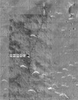
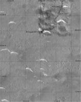
Meanwhile I wanted to show the difference between the existing map and the new Tianwen-1 orbiter image. My map is based on the published map with track and waypoints. The orbiter image shows tracks offset from it, with the offset increasing away from the lander (though the last point is close again). I suspect this is because of a small difference in the definitions of map projections between the projected orbiter image and the route map. (My coordinates are from HiRISE which opens the possibility of another offset, but in all cases I am matching to surface features using HiRISE as a standard). The maximum offset is about 10 m. Phil
-------------------- ... because the Solar System ain't gonna map itself.
Also to be found posting similar content on https://mastodon.social/@PhilStooke Maps for download (free PD: https://upload.wikimedia.org/wikipedia/comm...Cartography.pdf NOTE: everything created by me which I post on UMSF is considered to be in the public domain (NOT CC, public domain) |
||
|
|
|
||
 Phil Stooke Zhurong maps May 19 2021, 11:46 PM
 Phil Stooke Starting off with an overview of the site, with la... May 22 2021, 05:14 PM Greenish Until higher-res imagery arrives, here's a cro... May 23 2021, 03:55 AM Phil Stooke It's clear that following this mission will be... Jun 10 2021, 07:20 AM Phil Stooke OK, HiRISE image and a new location.
Phil
Jun 10 2021, 08:08 PM Phil Stooke The text accompanying the 'group photo' of... Jun 11 2021, 07:45 AM kymani76 I'm a bit late to the game as I had other work... Jun 12 2021, 11:34 AM kymani76
All landed hardware map in HiRise color. Grid at ... Jun 12 2021, 11:38 AM kymani76
Traverse map, based on tracks visible when enhanc... Jun 12 2021, 11:46 AM Phil Stooke After the second HiRISE image appeared I have made... Jun 24 2021, 03:56 AM Phil Stooke Bit by bit a map takes shape. This uses the new p... Jun 27 2021, 07:31 PM Phil Stooke And an overview map - this will be the standard re... Jun 27 2021, 08:25 PM Huguet And Zhurong is almost at the parachute... Would be... Jul 9 2021, 02:27 PM Bill Harris So, those light-toned features are barchan-like d... Jul 9 2021, 08:11 PM Phil Stooke The LIBS instrument will give composition - they w... Jul 9 2021, 09:25 PM Huguet China's Zhurong rover drives for over 410 mete... Jul 11 2021, 03:34 PM Phil Stooke I updated my map with the parachute images. The s... Jul 15 2021, 05:37 PM kymani76
As usual Phil beat me to the update, bur anyway h... Jul 16 2021, 09:07 PM Phil Stooke You are doing some really nice work here - for all... Jul 16 2021, 09:54 PM kymani76 Thanks Phil. Means a lot. In fact you just gave me... Jul 18 2021, 07:43 PM Phil Stooke I just had an interesting and very welcome email f... Jul 19 2021, 06:31 PM Phil Stooke The Chinese map I linked to in the main thread let... Jul 23 2021, 07:13 AM Phil Stooke My best guess for sol 75 would be right at the bot... Jul 31 2021, 07:21 AM kymani76
Tentative sol 75 update. I left the dates out, be... Aug 1 2021, 10:52 AM Hungry4info New drive map from here. Aug 17 2021, 08:30 PM Bill Harris I give them passing marks on autonomous driving (... Aug 19 2021, 05:26 AM ollopa QUOTE (Phil Stooke @ May 22 2021, 07:14 P... Aug 20 2021, 05:15 PM Phil Stooke You are right, it should be more like 30 km betwee... Aug 21 2021, 01:32 AM Hungry4info New drive map from here. Aug 30 2021, 10:29 AM Phil Stooke This map is very useful, but I am intrigued to fin... Aug 30 2021, 05:41 PM Huguet Amazing how detailed the orbiter get the track... ... Aug 31 2021, 12:13 AM Bill Harris Agreed. The 'quiet spell' from Zhurong is... Sep 18 2021, 01:51 PM Phil Stooke Here is an update to my map (section 2) based on t... Nov 8 2021, 08:09 PM kymani76
Recently new geological map for Zhurong landing s... Dec 24 2021, 09:26 AM kymani76
Sol 174 map update. Dec 24 2021, 09:30 AM Phil Stooke A very quick look at the end of year location. Th... Jan 1 2022, 08:10 AM kymani76
Sol 201 update in IRG color, based on latest ima... Jan 4 2022, 02:23 PM
Phil Stooke Starting off with an overview of the site, with la... May 22 2021, 05:14 PM Greenish Until higher-res imagery arrives, here's a cro... May 23 2021, 03:55 AM Phil Stooke It's clear that following this mission will be... Jun 10 2021, 07:20 AM Phil Stooke OK, HiRISE image and a new location.
Phil
Jun 10 2021, 08:08 PM Phil Stooke The text accompanying the 'group photo' of... Jun 11 2021, 07:45 AM kymani76 I'm a bit late to the game as I had other work... Jun 12 2021, 11:34 AM kymani76
All landed hardware map in HiRise color. Grid at ... Jun 12 2021, 11:38 AM kymani76
Traverse map, based on tracks visible when enhanc... Jun 12 2021, 11:46 AM Phil Stooke After the second HiRISE image appeared I have made... Jun 24 2021, 03:56 AM Phil Stooke Bit by bit a map takes shape. This uses the new p... Jun 27 2021, 07:31 PM Phil Stooke And an overview map - this will be the standard re... Jun 27 2021, 08:25 PM Huguet And Zhurong is almost at the parachute... Would be... Jul 9 2021, 02:27 PM Bill Harris So, those light-toned features are barchan-like d... Jul 9 2021, 08:11 PM Phil Stooke The LIBS instrument will give composition - they w... Jul 9 2021, 09:25 PM Huguet China's Zhurong rover drives for over 410 mete... Jul 11 2021, 03:34 PM Phil Stooke I updated my map with the parachute images. The s... Jul 15 2021, 05:37 PM kymani76
As usual Phil beat me to the update, bur anyway h... Jul 16 2021, 09:07 PM Phil Stooke You are doing some really nice work here - for all... Jul 16 2021, 09:54 PM kymani76 Thanks Phil. Means a lot. In fact you just gave me... Jul 18 2021, 07:43 PM Phil Stooke I just had an interesting and very welcome email f... Jul 19 2021, 06:31 PM Phil Stooke The Chinese map I linked to in the main thread let... Jul 23 2021, 07:13 AM Phil Stooke My best guess for sol 75 would be right at the bot... Jul 31 2021, 07:21 AM kymani76
Tentative sol 75 update. I left the dates out, be... Aug 1 2021, 10:52 AM Hungry4info New drive map from here. Aug 17 2021, 08:30 PM Bill Harris I give them passing marks on autonomous driving (... Aug 19 2021, 05:26 AM ollopa QUOTE (Phil Stooke @ May 22 2021, 07:14 P... Aug 20 2021, 05:15 PM Phil Stooke You are right, it should be more like 30 km betwee... Aug 21 2021, 01:32 AM Hungry4info New drive map from here. Aug 30 2021, 10:29 AM Phil Stooke This map is very useful, but I am intrigued to fin... Aug 30 2021, 05:41 PM Huguet Amazing how detailed the orbiter get the track... ... Aug 31 2021, 12:13 AM Bill Harris Agreed. The 'quiet spell' from Zhurong is... Sep 18 2021, 01:51 PM Phil Stooke Here is an update to my map (section 2) based on t... Nov 8 2021, 08:09 PM kymani76
Recently new geological map for Zhurong landing s... Dec 24 2021, 09:26 AM kymani76
Sol 174 map update. Dec 24 2021, 09:30 AM Phil Stooke A very quick look at the end of year location. Th... Jan 1 2022, 08:10 AM kymani76
Sol 201 update in IRG color, based on latest ima... Jan 4 2022, 02:23 PM
 Bill Harris QUOTE (kymani76 @ Jan 4 2022, 09:23 AM) a... Jan 5 2022, 02:51 AM kymani76 QUOTE (Bill Harris @ Jan 5 2022, 03:51 AM... Jan 5 2022, 08:03 PM Phil Stooke I assumed the partial panorama was from the end of... Jan 4 2022, 09:22 PM kymani76
Preliminary sol 262 map update, based on this map... Mar 15 2022, 04:34 PM kymani76 Recent article characterizing first 60 sols of Zhu... Mar 22 2022, 12:25 PM kymani76 Zhurong traverse updated with track visible in new... Mar 24 2022, 04:44 PM kymani76
In addition I also made elevation map with the ne... Mar 24 2022, 04:48 PM vikingmars QUOTE (kymani76 @ Mar 24 2022, 05:48 PM) ... Mar 24 2022, 06:28 PM kymani76 Zhurong rover map update. There is not a lot of ne... Mar 10 2023, 08:53 AM kymani76 false color IRG image version:
DEM version:
Mar 10 2023, 08:56 AM vikingmars QUOTE (kymani76 @ Mar 10 2023, 09:56 AM) ... Mar 13 2023, 02:28 PM Phil Stooke Following on the discussion about maps in the main... Jun 14 2023, 11:27 PM
Bill Harris QUOTE (kymani76 @ Jan 4 2022, 09:23 AM) a... Jan 5 2022, 02:51 AM kymani76 QUOTE (Bill Harris @ Jan 5 2022, 03:51 AM... Jan 5 2022, 08:03 PM Phil Stooke I assumed the partial panorama was from the end of... Jan 4 2022, 09:22 PM kymani76
Preliminary sol 262 map update, based on this map... Mar 15 2022, 04:34 PM kymani76 Recent article characterizing first 60 sols of Zhu... Mar 22 2022, 12:25 PM kymani76 Zhurong traverse updated with track visible in new... Mar 24 2022, 04:44 PM kymani76
In addition I also made elevation map with the ne... Mar 24 2022, 04:48 PM vikingmars QUOTE (kymani76 @ Mar 24 2022, 05:48 PM) ... Mar 24 2022, 06:28 PM kymani76 Zhurong rover map update. There is not a lot of ne... Mar 10 2023, 08:53 AM kymani76 false color IRG image version:
DEM version:
Mar 10 2023, 08:56 AM vikingmars QUOTE (kymani76 @ Mar 10 2023, 09:56 AM) ... Mar 13 2023, 02:28 PM Phil Stooke Following on the discussion about maps in the main... Jun 14 2023, 11:27 PM |

|
Lo-Fi Version | Time is now: 21st June 2024 - 09:07 AM |
|
RULES AND GUIDELINES Please read the Forum Rules and Guidelines before posting. IMAGE COPYRIGHT |
OPINIONS AND MODERATION Opinions expressed on UnmannedSpaceflight.com are those of the individual posters and do not necessarily reflect the opinions of UnmannedSpaceflight.com or The Planetary Society. The all-volunteer UnmannedSpaceflight.com moderation team is wholly independent of The Planetary Society. The Planetary Society has no influence over decisions made by the UnmannedSpaceflight.com moderators. |
SUPPORT THE FORUM Unmannedspaceflight.com is funded by the Planetary Society. Please consider supporting our work and many other projects by donating to the Society or becoming a member. |
|