Finishing work in and around Seitah, sols 238-378 |

Finishing work in and around Seitah, sols 238-378 |
 Oct 21 2021, 06:50 AM Oct 21 2021, 06:50 AM
Post
#301
|
|
|
Solar System Cartographer  Group: Members Posts: 10229 Joined: 5-April 05 From: Canada Member No.: 227 |
It's time to start a new thread - this will cover the remaining work in Seitah and the drive back to the landing site.
Phil -------------------- ... because the Solar System ain't gonna map itself.
Also to be found posting similar content on https://mastodon.social/@PhilStooke Maps for download (free PDF: https://upload.wikimedia.org/wikipedia/comm...Cartography.pdf NOTE: everything created by me which I post on UMSF is considered to be in the public domain (NOT CC, public domain) |
 |
 
|
 |
|
Mar 8 2022, 01:55 PM
Post
#302
|
||
 Member Group: Members Posts: 790 Joined: 9-May 21 From: Germany Member No.: 9017 |
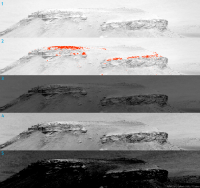
QUOTE (Bill Harris @ Mar 7 2022, 05:50 PM)  ... One thing I notice in your processing of these photos in this area is that their top "airfall coating" is very light, almost white in IR. It'll be interesting to look at that chemistry. ... The "top airfall coating" is most likely orange-brown dust, and it appears featureless white or very bright in my images due to clipped highlights in the Mastcam-Z raw images that I used. This clipping exists in all Mastcam-Z gray-scale raw images of filters 1 to 6 and in the red channel of filter 0 (RGB), where the clipped areas have the value 254. The "raw images" are obviously not raw in the sense of digital photography, where "raw" means straight out of the camera and not jpeg-ed. Because calibrated images from sol 364 are not yet available, here is an example from Sol 69 with the upper part of Kodiak hill: 1. Mastcam-Z right eye filter 1 (infrared) image from NASA's "Raw Images" site (link), with 8 bit per pixel, no details visible in the brightest part 2. Same as 1, all pixels with a value 254 are marked red 3. Calibrated image from the Planetary Data System Imaging Node with 16 bit per pixel, (link) 4. Same as 3, brightness adjusted 5. Same as 3, histogram adjusted to show the details in the brightest part on top of Kodiak hill
|
|
|
|
|
|
|
Mar 9 2022, 12:49 PM
Post
#303
|
|
|
Senior Member Group: Members Posts: 3009 Joined: 30-October 04 Member No.: 105 |
QUOTE (tau @ Mar 8 2022, 08:55 AM) The "top airfall coating" is most likely orange-brown dust, and it appears featureless white or very bright in my images due to clipped highlights in the Mastcam-Z raw images that I used. snip That makes sense. You're trying to show the maximum range down to shadowed areas, and some other areas need to fall by the wayside. --Bill -------------------- |
|
|
|
 Phil Stooke Finishing work in and around Seitah, sols 238-378 Oct 21 2021, 06:50 AM
 PaulH51 Sol 367: Raw WATSON camera image of the abrasion p... Mar 3 2022, 12:38 PM
 PaulH51 QUOTE (PaulH51 @ Mar 3 2022, 08:38 PM) So... Mar 3 2022, 09:42 PM tau Sol 367 SHERLOC WATSON camera image of the abrasio... Mar 3 2022, 02:10 PM tau Sol 363 SHERLOC WATSON camera image of the surface... Mar 3 2022, 07:32 PM tau Part of the abrasion patch on the boulder "Si... Mar 6 2022, 04:36 PM Bill Harris QUOTE (tau @ Mar 6 2022, 11:36 AM) Part o... Mar 8 2022, 01:16 AM tau Sol 364 Mastcam-Z
1. Right eye filter 0 (RGB, slig... Mar 7 2022, 04:01 PM Bill Harris "vesicular rocks orange-brown in infrared fal... Mar 7 2022, 04:50 PM Phil Stooke A new name from an LPSC talk by Sholes et al., (ab... Mar 8 2022, 04:18 AM mcaplinger QUOTE (tau @ Mar 8 2022, 05:55 AM) The ... Mar 8 2022, 04:36 PM Phil Stooke A new drill hole at Sid, sol 371.
This is a compo... Mar 8 2022, 04:18 PM fredk Indeed, and since the "raw" images are a... Mar 8 2022, 06:00 PM mcaplinger QUOTE (fredk @ Mar 8 2022, 10:00 AM) Anot... Mar 8 2022, 06:21 PM fredk Thanks - I forgot about the companding.
So in Tau... Mar 8 2022, 06:31 PM Cherurbino Attached is the thumbnail of this 18 Mb 13367x2026... Mar 11 2022, 05:40 AM Ant103 This is a Sol 96 MastcamZ panorama. Here's my ... Mar 11 2022, 10:56 AM Cherurbino QUOTE (Ant103 @ Mar 11 2022, 02:56 PM) Th... Mar 11 2022, 03:15 PM tau This is Hahóóts'aa'
By the way: I have ... Mar 11 2022, 09:08 PM tau In the panorama of the previous post, only the nor... Mar 13 2022, 09:25 PM Cherurbino QUOTE (tau @ Mar 14 2022, 01:25 AM) We ca... Mar 14 2022, 02:28 AM tau A sol 96 Mastcam-Z anaglyph of the panorama with H... Mar 13 2022, 09:33 PM tau These are two lines of sight, connecting the rover... Mar 14 2022, 08:56 AM Cherurbino QUOTE (tau @ Mar 14 2022, 12:56 PM) These... Mar 14 2022, 01:43 PM PaulH51 QUOTE (Cherurbino @ Mar 14 2022, 09:43 PM... Mar 14 2022, 11:21 PM vjkane Lori Glaze presented this slide detailing the samp... Mar 27 2022, 12:06 AM Cherurbino QUOTE (vjkane @ Mar 27 2022, 04:06 AM) So... Mar 27 2022, 11:42 AM vjkane QUOTE (Cherurbino @ Mar 27 2022, 03:42 AM... Mar 27 2022, 01:03 PM neo56 My take on the full sky panorama taken with Navcam... May 11 2022, 06:44 PM Phil Stooke Larry Crumpler has not updated his Rover Field Rep... Dec 2 2023, 07:01 PM kymani76
Phil, thank you. I went straight for the data fi... Dec 3 2023, 10:47 AM
PaulH51 QUOTE (PaulH51 @ Mar 3 2022, 08:38 PM) So... Mar 3 2022, 09:42 PM tau Sol 367 SHERLOC WATSON camera image of the abrasio... Mar 3 2022, 02:10 PM tau Sol 363 SHERLOC WATSON camera image of the surface... Mar 3 2022, 07:32 PM tau Part of the abrasion patch on the boulder "Si... Mar 6 2022, 04:36 PM Bill Harris QUOTE (tau @ Mar 6 2022, 11:36 AM) Part o... Mar 8 2022, 01:16 AM tau Sol 364 Mastcam-Z
1. Right eye filter 0 (RGB, slig... Mar 7 2022, 04:01 PM Bill Harris "vesicular rocks orange-brown in infrared fal... Mar 7 2022, 04:50 PM Phil Stooke A new name from an LPSC talk by Sholes et al., (ab... Mar 8 2022, 04:18 AM mcaplinger QUOTE (tau @ Mar 8 2022, 05:55 AM) The ... Mar 8 2022, 04:36 PM Phil Stooke A new drill hole at Sid, sol 371.
This is a compo... Mar 8 2022, 04:18 PM fredk Indeed, and since the "raw" images are a... Mar 8 2022, 06:00 PM mcaplinger QUOTE (fredk @ Mar 8 2022, 10:00 AM) Anot... Mar 8 2022, 06:21 PM fredk Thanks - I forgot about the companding.
So in Tau... Mar 8 2022, 06:31 PM Cherurbino Attached is the thumbnail of this 18 Mb 13367x2026... Mar 11 2022, 05:40 AM Ant103 This is a Sol 96 MastcamZ panorama. Here's my ... Mar 11 2022, 10:56 AM Cherurbino QUOTE (Ant103 @ Mar 11 2022, 02:56 PM) Th... Mar 11 2022, 03:15 PM tau This is Hahóóts'aa'
By the way: I have ... Mar 11 2022, 09:08 PM tau In the panorama of the previous post, only the nor... Mar 13 2022, 09:25 PM Cherurbino QUOTE (tau @ Mar 14 2022, 01:25 AM) We ca... Mar 14 2022, 02:28 AM tau A sol 96 Mastcam-Z anaglyph of the panorama with H... Mar 13 2022, 09:33 PM tau These are two lines of sight, connecting the rover... Mar 14 2022, 08:56 AM Cherurbino QUOTE (tau @ Mar 14 2022, 12:56 PM) These... Mar 14 2022, 01:43 PM PaulH51 QUOTE (Cherurbino @ Mar 14 2022, 09:43 PM... Mar 14 2022, 11:21 PM vjkane Lori Glaze presented this slide detailing the samp... Mar 27 2022, 12:06 AM Cherurbino QUOTE (vjkane @ Mar 27 2022, 04:06 AM) So... Mar 27 2022, 11:42 AM vjkane QUOTE (Cherurbino @ Mar 27 2022, 03:42 AM... Mar 27 2022, 01:03 PM neo56 My take on the full sky panorama taken with Navcam... May 11 2022, 06:44 PM Phil Stooke Larry Crumpler has not updated his Rover Field Rep... Dec 2 2023, 07:01 PM kymani76
Phil, thank you. I went straight for the data fi... Dec 3 2023, 10:47 AM |

|
Lo-Fi Version | Time is now: 27th September 2024 - 02:12 AM |
|
RULES AND GUIDELINES Please read the Forum Rules and Guidelines before posting. IMAGE COPYRIGHT |
OPINIONS AND MODERATION Opinions expressed on UnmannedSpaceflight.com are those of the individual posters and do not necessarily reflect the opinions of UnmannedSpaceflight.com or The Planetary Society. The all-volunteer UnmannedSpaceflight.com moderation team is wholly independent of The Planetary Society. The Planetary Society has no influence over decisions made by the UnmannedSpaceflight.com moderators. |
SUPPORT THE FORUM Unmannedspaceflight.com is funded by the Planetary Society. Please consider supporting our work and many other projects by donating to the Society or becoming a member. |
|