Zhurong maps, traverse route and location mapping |

Zhurong maps, traverse route and location mapping |
 May 19 2021, 11:46 PM May 19 2021, 11:46 PM
Post
#1
|
|
|
Solar System Cartographer  Group: Members Posts: 10192 Joined: 5-April 05 From: Canada Member No.: 227 |
I'm starting a map thread. It's hard to know what we will get but I expect a route map will emerge bit by bit. Maps showing the landing location will be easier to make initially.
Phil -------------------- ... because the Solar System ain't gonna map itself.
Also to be found posting similar content on https://mastodon.social/@PhilStooke Maps for download (free PD: https://upload.wikimedia.org/wikipedia/comm...Cartography.pdf NOTE: everything created by me which I post on UMSF is considered to be in the public domain (NOT CC, public domain) |
 |
 
|
 |
|
Mar 22 2022, 12:25 PM
Post
#2
|
||
 Member Group: Members Posts: 349 Joined: 20-June 07 From: Slovenia Member No.: 2461 |
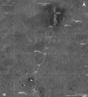
Recent article characterizing first 60 sols of Zhurong traverse was published in Nature Geoscience.
While the article is sadly behind paywall it is possible to download supplemental files which include rover's track points. Here is a comparison map of my version of traverse vs the new track points in red:
|
|
|
|
|
|
 Phil Stooke Zhurong maps May 19 2021, 11:46 PM
 Huguet Amazing how detailed the orbiter get the track... ... Aug 31 2021, 12:13 AM Phil Stooke We have had no news on Tianwen-1 and Zhurong for a... Sep 17 2021, 05:45 PM Bill Harris Agreed. The 'quiet spell' from Zhurong is... Sep 18 2021, 01:51 PM Phil Stooke Here is an update to my map (section 2) based on t... Nov 8 2021, 08:09 PM kymani76
Recently new geological map for Zhurong landing s... Dec 24 2021, 09:26 AM kymani76
Sol 174 map update. Dec 24 2021, 09:30 AM Phil Stooke A very quick look at the end of year location. Th... Jan 1 2022, 08:10 AM kymani76
Sol 201 update in IRG color, based on latest ima... Jan 4 2022, 02:23 PM
Huguet Amazing how detailed the orbiter get the track... ... Aug 31 2021, 12:13 AM Phil Stooke We have had no news on Tianwen-1 and Zhurong for a... Sep 17 2021, 05:45 PM Bill Harris Agreed. The 'quiet spell' from Zhurong is... Sep 18 2021, 01:51 PM Phil Stooke Here is an update to my map (section 2) based on t... Nov 8 2021, 08:09 PM kymani76
Recently new geological map for Zhurong landing s... Dec 24 2021, 09:26 AM kymani76
Sol 174 map update. Dec 24 2021, 09:30 AM Phil Stooke A very quick look at the end of year location. Th... Jan 1 2022, 08:10 AM kymani76
Sol 201 update in IRG color, based on latest ima... Jan 4 2022, 02:23 PM
 Bill Harris QUOTE (kymani76 @ Jan 4 2022, 09:23 AM) a... Jan 5 2022, 02:51 AM kymani76 QUOTE (Bill Harris @ Jan 5 2022, 03:51 AM... Jan 5 2022, 08:03 PM Phil Stooke I assumed the partial panorama was from the end of... Jan 4 2022, 09:22 PM kymani76
Preliminary sol 262 map update, based on this map... Mar 15 2022, 04:34 PM kymani76 Zhurong traverse updated with track visible in new... Mar 24 2022, 04:44 PM kymani76
In addition I also made elevation map with the ne... Mar 24 2022, 04:48 PM vikingmars QUOTE (kymani76 @ Mar 24 2022, 05:48 PM) ... Mar 24 2022, 06:28 PM kymani76 Zhurong rover map update. There is not a lot of ne... Mar 10 2023, 08:53 AM kymani76 false color IRG image version:
DEM version:
Mar 10 2023, 08:56 AM vikingmars QUOTE (kymani76 @ Mar 10 2023, 09:56 AM) ... Mar 13 2023, 02:28 PM Phil Stooke Following on the discussion about maps in the main... Jun 14 2023, 11:27 PM
Bill Harris QUOTE (kymani76 @ Jan 4 2022, 09:23 AM) a... Jan 5 2022, 02:51 AM kymani76 QUOTE (Bill Harris @ Jan 5 2022, 03:51 AM... Jan 5 2022, 08:03 PM Phil Stooke I assumed the partial panorama was from the end of... Jan 4 2022, 09:22 PM kymani76
Preliminary sol 262 map update, based on this map... Mar 15 2022, 04:34 PM kymani76 Zhurong traverse updated with track visible in new... Mar 24 2022, 04:44 PM kymani76
In addition I also made elevation map with the ne... Mar 24 2022, 04:48 PM vikingmars QUOTE (kymani76 @ Mar 24 2022, 05:48 PM) ... Mar 24 2022, 06:28 PM kymani76 Zhurong rover map update. There is not a lot of ne... Mar 10 2023, 08:53 AM kymani76 false color IRG image version:
DEM version:
Mar 10 2023, 08:56 AM vikingmars QUOTE (kymani76 @ Mar 10 2023, 09:56 AM) ... Mar 13 2023, 02:28 PM Phil Stooke Following on the discussion about maps in the main... Jun 14 2023, 11:27 PM |

|
Lo-Fi Version | Time is now: 13th June 2024 - 08:28 PM |
|
RULES AND GUIDELINES Please read the Forum Rules and Guidelines before posting. IMAGE COPYRIGHT |
OPINIONS AND MODERATION Opinions expressed on UnmannedSpaceflight.com are those of the individual posters and do not necessarily reflect the opinions of UnmannedSpaceflight.com or The Planetary Society. The all-volunteer UnmannedSpaceflight.com moderation team is wholly independent of The Planetary Society. The Planetary Society has no influence over decisions made by the UnmannedSpaceflight.com moderators. |
SUPPORT THE FORUM Unmannedspaceflight.com is funded by the Planetary Society. Please consider supporting our work and many other projects by donating to the Society or becoming a member. |
|