Traverse to the Delta, sols 379-414, 15 Mar 2022- 21 Apr 2022 |

Traverse to the Delta, sols 379-414, 15 Mar 2022- 21 Apr 2022 |
 Mar 16 2022, 12:02 AM Mar 16 2022, 12:02 AM
Post
#1
|
||
|
Solar System Cartographer  Group: Members Posts: 10184 Joined: 5-April 05 From: Canada Member No.: 227 |
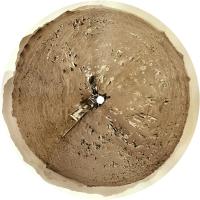
Starting a new thread as we leave the landing site and start the drive around Seitah. It will probably be quite fast unless something interesting turns up in the ejecta of the craters along the path.
Here is a circular panorama for sol 379, already north of the landing site. Maybe there will be some drive-by shots of the landing site itself. Phil
-------------------- ... because the Solar System ain't gonna map itself.
Also to be found posting similar content on https://mastodon.social/@PhilStooke Maps for download (free PD: https://upload.wikimedia.org/wikipedia/comm...Cartography.pdf NOTE: everything created by me which I post on UMSF is considered to be in the public domain (NOT CC, public domain) |
|
 |
 
|
|
 |
|
Apr 20 2022, 07:13 AM
Post
#2
|
||
|
Solar System Cartographer Group: Members Posts: 10184 Joined: 5-April 05 From: Canada Member No.: 227 |
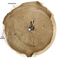
Here is the sol 413 panorama in circular form. I added the two names from the press release where I assume they are located (Hawksbill Gap was shown on a map at LPSC, I am guessing the other location). This is the best view we have had yet of one of these troughs in the landscape.
Phil
-------------------- ... because the Solar System ain't gonna map itself.
Also to be found posting similar content on https://mastodon.social/@PhilStooke Maps for download (free PD: https://upload.wikimedia.org/wikipedia/comm...Cartography.pdf NOTE: everything created by me which I post on UMSF is considered to be in the public domain (NOT CC, public domain) |
|
|
|
|
|
|
Apr 20 2022, 04:42 PM
Post
#3
|
||
|
Junior Member Group: Members Posts: 91 Joined: 11-August 21 Member No.: 9072 |
QUOTE (Phil Stooke @ Apr 20 2022, 10:13 AM)  Here is the sol 413 panorama in circular form. I added the two names from the press release where I assume they are located (Hawksbill Gap was shown on a map at LPSC, I am guessing the other location). This is the best view we have had yet of one of these troughs in the landscape. Thank you, Phil! A few hours before I asked about it in another topic:Phil
QUOTE (Cherurbino @ Apr 20 2022, 08:54 AM) ... Yesterday the new Delta Front Campaign plan was published. May I ask anybody to draw the arrows for Cape Nukshak and Hawksbill Gap mentioned there? I don't have the instruments to unwrap the circular projection. is it possible to put the arrows onto some common map? Thank you. --Cherurbino |
|
|
|
|
|
 Phil Stooke Traverse to the Delta, sols 379-414 Mar 16 2022, 12:02 AM
 Phil Stooke Sol 405 - the afternoon panorama in circular form.... Apr 11 2022, 08:09 PM Ant103 Sol 405 Navcam panoramic is just great. The base o... Apr 12 2022, 11:57 AM tau 97 new Mastcam-Z raw images of the delta from sol ... Apr 12 2022, 12:54 PM
 Keltos QUOTE (tau @ Apr 12 2022, 01:54 PM) 97 ne... Apr 12 2022, 02:24 PM
 Saturns Moon Titan QUOTE (tau @ Apr 12 2022, 01:54 PM) 97 ne... Apr 12 2022, 06:08 PM Nahúm QUOTE (Saturns Moon Titan @ Apr 12 2022, 07... Apr 12 2022, 08:40 PM neo56 Panorama taken with Mastcam-Z Left on sol 406 at 9... Apr 12 2022, 08:14 PM Saturns Moon Titan QUOTE (neo56 @ Apr 12 2022, 09:14 PM) Pan... Apr 12 2022, 11:40 PM john_s The images of the conglomerate bed are wonderful- ... Apr 13 2022, 12:48 AM Phil Stooke The curving structure in Tau's third image mig... Apr 12 2022, 08:38 PM Bill Harris QUOTE (Phil Stooke @ Apr 12 2022, 03:38 P... Apr 13 2022, 05:48 PM serpens Looking at the context of this deposit in Neo56... Apr 12 2022, 11:25 PM Saturns Moon Titan Fair question actually, that's possible. I... Apr 13 2022, 08:15 AM neo56 Three cropped versions of the huge Mastcam-Z panor... Apr 13 2022, 05:34 PM tau QUOTE (john_s @ Apr 13 2022, 02:48 AM) Th... Apr 13 2022, 08:35 PM Saturns Moon Titan QUOTE (tau @ Apr 13 2022, 09:35 PM) A com... Apr 14 2022, 09:35 AM serpens QUOTE (Saturns Moon Titan @ Apr 14 2022, 09... Apr 17 2022, 06:25 AM Phil Stooke Great pictures of a wonderful landscape. Here is ... Apr 14 2022, 02:23 AM StargazeInWonder The east face of the delta looks completely imposs... Apr 14 2022, 04:28 AM Phil Stooke We haven't seen it from the ground, but I am l... Apr 14 2022, 06:14 AM Julius I am starting to wonder whether could this all be ... Apr 14 2022, 06:43 AM Phil Stooke Sol 408 circular panorama. Those linear troughs, ... Apr 14 2022, 09:56 PM Toma B Kodiak Hill imaged by Mars Perseverances Mastcam-Z... Apr 15 2022, 05:23 PM neo56 Kodiak Hill imaged by Navcam Left camera on sol 40... Apr 15 2022, 07:32 PM neo56 My take on the Mastcam-Z Left mosaic of sol 409 an... Apr 15 2022, 08:29 PM Phil Stooke Sol 409 circular panorama. A very cool place.
Ph... Apr 15 2022, 09:24 PM vikingmars Sol 410 : the backshell and its parachute seen aga... Apr 16 2022, 09:19 AM tau Sol 409 Mastcam-Z mosaic of Kodiak with enhanced c... Apr 16 2022, 01:53 PM Ant103 QUOTE (Phil Stooke @ Apr 15 2022, 11:24 P... Apr 17 2022, 09:31 AM tau Sol 411 Mastcam-Z mosaic with enhanced colors and ... Apr 18 2022, 05:03 PM SulliedGoon QUOTE (tau @ Apr 18 2022, 11:03 AM) two ... Apr 19 2022, 02:55 AM neo56 Panorama taken on sol 411 with Mastcam-Z Left. Thr... Apr 19 2022, 08:22 PM john_s Fabulous mosaic! I expect the layered units a... Apr 19 2022, 10:45 PM PaulH51 Perseverance on the move once again after pausing ... Apr 19 2022, 11:11 AM Julius What is the trough ahead of the rover, also visibl... Apr 19 2022, 11:20 AM Gladstoner They could be going to the low platform directly t... Apr 20 2022, 03:38 AM Saturns Moon Titan QUOTE (Phil Stooke @ Apr 20 2022, 08:13 A... Apr 20 2022, 09:47 AM Phil Stooke This is a detail enlarged from a presentation Paul... Apr 20 2022, 05:23 PM Bill Harris Is there any supposition of what we think that fur... Apr 20 2022, 05:56 PM Deimos https://www.nasa.gov/feature/jpl/nasa-s-per...ecli... Apr 20 2022, 06:19 PM fredk QUOTE (Deimos @ Apr 20 2022, 07:19 PM) ht... Apr 21 2022, 06:58 PM StargazeInWonder 1) An interesting thing about the Phobos eclipse i... Apr 21 2022, 07:07 PM djellison QUOTE (StargazeInWonder @ Apr 21 2022, 12... Apr 21 2022, 08:37 PM neo56 Some parts of the panorama taken on sol 411 with M... Apr 20 2022, 07:20 PM charborob Sol 414 LMastcam-Z:
Apr 21 2022, 02:06 PM Bill Harris One aspect of those meter-sized boulders is how ro... Apr 29 2022, 10:17 AM PDP8E A little late ... ( and somewhat back in action )
... Oct 15 2022, 07:02 PM Phil Stooke https://mars.nasa.gov/resources/27056/perse...e-vi... Oct 16 2022, 06:22 AM MahFL There is still one thing I don't fully underst... Oct 16 2022, 06:28 PM mcaplinger QUOTE (MahFL @ Oct 16 2022, 10:28 AM) The... Oct 16 2022, 06:49 PM mcaplinger QUOTE (Phil Stooke @ Oct 15 2022, 10:22 P... Oct 17 2022, 07:16 PM scalbers Revisiting Sol 389 with large version link.
So... Oct 7 2023, 07:12 PM scalbers Sol 387 with large version link.
Extended drive... Oct 7 2023, 08:49 PM
Saturns Moon Titan QUOTE (tau @ Apr 12 2022, 01:54 PM) 97 ne... Apr 12 2022, 06:08 PM Nahúm QUOTE (Saturns Moon Titan @ Apr 12 2022, 07... Apr 12 2022, 08:40 PM neo56 Panorama taken with Mastcam-Z Left on sol 406 at 9... Apr 12 2022, 08:14 PM Saturns Moon Titan QUOTE (neo56 @ Apr 12 2022, 09:14 PM) Pan... Apr 12 2022, 11:40 PM john_s The images of the conglomerate bed are wonderful- ... Apr 13 2022, 12:48 AM Phil Stooke The curving structure in Tau's third image mig... Apr 12 2022, 08:38 PM Bill Harris QUOTE (Phil Stooke @ Apr 12 2022, 03:38 P... Apr 13 2022, 05:48 PM serpens Looking at the context of this deposit in Neo56... Apr 12 2022, 11:25 PM Saturns Moon Titan Fair question actually, that's possible. I... Apr 13 2022, 08:15 AM neo56 Three cropped versions of the huge Mastcam-Z panor... Apr 13 2022, 05:34 PM tau QUOTE (john_s @ Apr 13 2022, 02:48 AM) Th... Apr 13 2022, 08:35 PM Saturns Moon Titan QUOTE (tau @ Apr 13 2022, 09:35 PM) A com... Apr 14 2022, 09:35 AM serpens QUOTE (Saturns Moon Titan @ Apr 14 2022, 09... Apr 17 2022, 06:25 AM Phil Stooke Great pictures of a wonderful landscape. Here is ... Apr 14 2022, 02:23 AM StargazeInWonder The east face of the delta looks completely imposs... Apr 14 2022, 04:28 AM Phil Stooke We haven't seen it from the ground, but I am l... Apr 14 2022, 06:14 AM Julius I am starting to wonder whether could this all be ... Apr 14 2022, 06:43 AM Phil Stooke Sol 408 circular panorama. Those linear troughs, ... Apr 14 2022, 09:56 PM Toma B Kodiak Hill imaged by Mars Perseverances Mastcam-Z... Apr 15 2022, 05:23 PM neo56 Kodiak Hill imaged by Navcam Left camera on sol 40... Apr 15 2022, 07:32 PM neo56 My take on the Mastcam-Z Left mosaic of sol 409 an... Apr 15 2022, 08:29 PM Phil Stooke Sol 409 circular panorama. A very cool place.
Ph... Apr 15 2022, 09:24 PM vikingmars Sol 410 : the backshell and its parachute seen aga... Apr 16 2022, 09:19 AM tau Sol 409 Mastcam-Z mosaic of Kodiak with enhanced c... Apr 16 2022, 01:53 PM Ant103 QUOTE (Phil Stooke @ Apr 15 2022, 11:24 P... Apr 17 2022, 09:31 AM tau Sol 411 Mastcam-Z mosaic with enhanced colors and ... Apr 18 2022, 05:03 PM SulliedGoon QUOTE (tau @ Apr 18 2022, 11:03 AM) two ... Apr 19 2022, 02:55 AM neo56 Panorama taken on sol 411 with Mastcam-Z Left. Thr... Apr 19 2022, 08:22 PM john_s Fabulous mosaic! I expect the layered units a... Apr 19 2022, 10:45 PM PaulH51 Perseverance on the move once again after pausing ... Apr 19 2022, 11:11 AM Julius What is the trough ahead of the rover, also visibl... Apr 19 2022, 11:20 AM Gladstoner They could be going to the low platform directly t... Apr 20 2022, 03:38 AM Saturns Moon Titan QUOTE (Phil Stooke @ Apr 20 2022, 08:13 A... Apr 20 2022, 09:47 AM Phil Stooke This is a detail enlarged from a presentation Paul... Apr 20 2022, 05:23 PM Bill Harris Is there any supposition of what we think that fur... Apr 20 2022, 05:56 PM Deimos https://www.nasa.gov/feature/jpl/nasa-s-per...ecli... Apr 20 2022, 06:19 PM fredk QUOTE (Deimos @ Apr 20 2022, 07:19 PM) ht... Apr 21 2022, 06:58 PM StargazeInWonder 1) An interesting thing about the Phobos eclipse i... Apr 21 2022, 07:07 PM djellison QUOTE (StargazeInWonder @ Apr 21 2022, 12... Apr 21 2022, 08:37 PM neo56 Some parts of the panorama taken on sol 411 with M... Apr 20 2022, 07:20 PM charborob Sol 414 LMastcam-Z:
Apr 21 2022, 02:06 PM Bill Harris One aspect of those meter-sized boulders is how ro... Apr 29 2022, 10:17 AM PDP8E A little late ... ( and somewhat back in action )
... Oct 15 2022, 07:02 PM Phil Stooke https://mars.nasa.gov/resources/27056/perse...e-vi... Oct 16 2022, 06:22 AM MahFL There is still one thing I don't fully underst... Oct 16 2022, 06:28 PM mcaplinger QUOTE (MahFL @ Oct 16 2022, 10:28 AM) The... Oct 16 2022, 06:49 PM mcaplinger QUOTE (Phil Stooke @ Oct 15 2022, 10:22 P... Oct 17 2022, 07:16 PM scalbers Revisiting Sol 389 with large version link.
So... Oct 7 2023, 07:12 PM scalbers Sol 387 with large version link.
Extended drive... Oct 7 2023, 08:49 PM |

|
Lo-Fi Version | Time is now: 5th June 2024 - 08:24 AM |
|
RULES AND GUIDELINES Please read the Forum Rules and Guidelines before posting. IMAGE COPYRIGHT |
OPINIONS AND MODERATION Opinions expressed on UnmannedSpaceflight.com are those of the individual posters and do not necessarily reflect the opinions of UnmannedSpaceflight.com or The Planetary Society. The all-volunteer UnmannedSpaceflight.com moderation team is wholly independent of The Planetary Society. The Planetary Society has no influence over decisions made by the UnmannedSpaceflight.com moderators. |
SUPPORT THE FORUM Unmannedspaceflight.com is funded by the Planetary Society. Please consider supporting our work and many other projects by donating to the Society or becoming a member. |
|