Yutu-2 route map |

Yutu-2 route map |
 Jan 3 2019, 09:04 PM Jan 3 2019, 09:04 PM
Post
#101
|
||
|
Solar System Cartographer  Group: Members Posts: 10166 Joined: 5-April 05 From: Canada Member No.: 227 |
I am setting this up to record activities of Yutu 2, but it looks as if this will be difficult unless we start to see more data releases. As soon as LRO images the lander (and the image is released) I can put a rough background on the map. When descent images of the actual site are released thay can be improved on. Until then this will be very simple.
Let me know if you see any signs of maps or feature names, including in the background of a TV broadcast or on a forum. Meanwhile, a first contribution. So simple it's almost not necessary, but you have to start somewhere. So rough I am not including a scale yet. I welcome anyone else's maps as well. Phil
-------------------- ... because the Solar System ain't gonna map itself.
Also to be found posting similar content on https://mastodon.social/@PhilStooke Maps for download (free PD: https://upload.wikimedia.org/wikipedia/comm...Cartography.pdf NOTE: everything created by me which I post on UMSF is considered to be in the public domain (NOT CC, public domain) |
|
 |
 
|
|
 |
|
Sep 5 2023, 07:19 PM
Post
#102
|
||
|
Solar System Cartographer Group: Members Posts: 10166 Joined: 5-April 05 From: Canada Member No.: 227 |
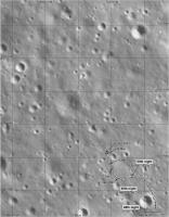
Andrew Jones has tweeted ( I can't say 'Xed') new Yutu 2 images from Seger Yu:
https://twitter.com/AJ_FI/status/1698603095289221546 (follow the link for more images) They allow a map update because the craters can be identified in LRO images and the tracks interpolated. Slow progress - suggesting either focussed science work in this area, or perhaps reduced communication opportunities via the aging Queqiao relay satellite. So here is a Yutu 2 map update for June 2023:
Phil -------------------- ... because the Solar System ain't gonna map itself.
Also to be found posting similar content on https://mastodon.social/@PhilStooke Maps for download (free PD: https://upload.wikimedia.org/wikipedia/comm...Cartography.pdf NOTE: everything created by me which I post on UMSF is considered to be in the public domain (NOT CC, public domain) |
|
|
|
|
|
|
Sep 6 2023, 01:35 AM
Post
#103
|
|
|
Member Group: Members Posts: 401 Joined: 5-January 07 From: Manchester England Member No.: 1563 |
As ever: Thanks for doing this Phil!
-------------------- |
|
|
|
 Phil Stooke Yutu-2 route map Jan 3 2019, 09:04 PM
 Phil Stooke Another context map. A description of how it was ... Jun 18 2022, 03:11 AM Phil Stooke Here is the full map up to day 44. It leaves me u... Jul 25 2022, 03:25 AM Phil Stooke The first part of a map update to the end of lunar... Jan 3 2023, 10:06 PM
 Thorsten Denk QUOTE (Phil Stooke @ Jan 3 2023, 11:06 PM... Jan 6 2023, 11:10 AM Phil Stooke Here are two sections of my Yutu 2 route map at th... Jan 4 2023, 04:13 AM Phil Stooke And my update of the full map... which needs an ex... Jan 4 2023, 05:01 AM Phil Stooke Good point, Thorsten!
A new map at last! ... Jul 12 2023, 06:11 AM Phil Stooke You're welcome!
Here is the full traverse... Sep 12 2023, 06:54 AM Phil Stooke The same path shown on a topo map - green is low, ... Sep 19 2023, 06:50 AM Phil Stooke https://m.weibo.cn/p/index?extparam=%E6%9C%...a0d2... Sep 27 2023, 08:09 PM Phil Stooke Andrew Jones tweeted a map up to the present date ... Sep 30 2023, 02:33 AM Phil Stooke My full map up to the end of day 59.
Phil
Oct 16 2023, 06:10 PM Phil Stooke My estimate of the new position based on that new ... Mar 4 2024, 09:28 PM
Thorsten Denk QUOTE (Phil Stooke @ Jan 3 2023, 11:06 PM... Jan 6 2023, 11:10 AM Phil Stooke Here are two sections of my Yutu 2 route map at th... Jan 4 2023, 04:13 AM Phil Stooke And my update of the full map... which needs an ex... Jan 4 2023, 05:01 AM Phil Stooke Good point, Thorsten!
A new map at last! ... Jul 12 2023, 06:11 AM Phil Stooke You're welcome!
Here is the full traverse... Sep 12 2023, 06:54 AM Phil Stooke The same path shown on a topo map - green is low, ... Sep 19 2023, 06:50 AM Phil Stooke https://m.weibo.cn/p/index?extparam=%E6%9C%...a0d2... Sep 27 2023, 08:09 PM Phil Stooke Andrew Jones tweeted a map up to the present date ... Sep 30 2023, 02:33 AM Phil Stooke My full map up to the end of day 59.
Phil
Oct 16 2023, 06:10 PM Phil Stooke My estimate of the new position based on that new ... Mar 4 2024, 09:28 PM |

|
Lo-Fi Version | Time is now: 23rd May 2024 - 03:30 AM |
|
RULES AND GUIDELINES Please read the Forum Rules and Guidelines before posting. IMAGE COPYRIGHT |
OPINIONS AND MODERATION Opinions expressed on UnmannedSpaceflight.com are those of the individual posters and do not necessarily reflect the opinions of UnmannedSpaceflight.com or The Planetary Society. The all-volunteer UnmannedSpaceflight.com moderation team is wholly independent of The Planetary Society. The Planetary Society has no influence over decisions made by the UnmannedSpaceflight.com moderators. |
SUPPORT THE FORUM Unmannedspaceflight.com is funded by the Planetary Society. Please consider supporting our work and many other projects by donating to the Society or becoming a member. |
|