Juno Perijove 57, December 30, 2023 |

Juno Perijove 57, December 30, 2023 |
 Oct 19 2023, 09:08 PM Oct 19 2023, 09:08 PM
Post
#1
|
|||||||
 Senior Member  Group: Moderator Posts: 3233 Joined: 11-February 04 From: Tucson, AZ Member No.: 23 |
I know the first close Io flyby is still a couple of months away but I'm going to go ahead and start up the topic now with a few preview images that the global map from PJ55 into the pixel scale, lighting conditions, and orientation of the highest resolution images that JunoCam would take (illuminated by the sun, there's always a chance for Jupiter-shine images), based on the current reference spk and c-kernel:
This also assumes an image cadence of 1 every other rotation (so 1 per minute). info about the encounter: CODE Perijove Date (UTC) SC Altitude (Io, km) SC Latitude (Io IAU, deg) SC W Longitude (Io IAU, deg) Vinf (Io, km/s) Phase Angle Magnetic Latitude of Io (Jupiter System III, deg) E Longitude of Io (Jupiter System III, deg) True Anomaly of Io (deg) Separation Angle
PJ57 12/30/2023 08:36:00.681 1500.021 63.694 94.641 30.047 108.885 3.418 228.269 248.805 21.175 -------------------- &@^^!% Jim! I'm a geologist, not a physicist!
The Gish Bar Times - A Blog all about Jupiter's Moon Io |
||||||
 |
 
|
||||||
 |
|
Jan 2 2024, 06:40 AM
Post
#2
|
|
|
Newbie Group: Members Posts: 3 Joined: 13-May 16 Member No.: 7956 |
Hello UMSF members,
I follow everyday all your exchanges about lunar and planetary missions. I'm one of the co-authors of the "Virtual Moon Atlas" (VMA) and "Virtual Planets Atlas" (VPA) freewares. https://ap-i.net/avl/en/start https://ap-i.net/avp/en/start Our goal is to provide for general public and scientists, easy to use basic tools for improving lunar and planetary knowledge. As you will see if you download and try it, VPA presents telluric planets and Galileo satellites real time maps. For that, we use with permission equirectangular "textures" in the 2:1 ratio buit from various planets maps found on the Internet and publically available. I would like to add in VPA Juno's maps of the Galileo satellites since presently, there are only Voyagers and Galileo maps used in the freeware. Using the VPA "double window" functionnality, it will certainly be useful to look for planetary surface evolutions between these various missions for VPA users. Does anyone could help us and provide such best resolution equirectangular Juno maps for Io (Sure !) but also for Europa and Ganymede that can be used in VPA with permission and thanks ? (Natural or enhanced colors / B&W / 2:1 ratio / jpg format / 4000x2000 pixels minimum or more) Thank you in advance for your support to our action if you agree. Ch. Legrand PS : Sorry for my rather poor english |
|
|
|
 volcanopele Juno Perijove 57 Oct 19 2023, 09:08 PM
 volcanopele Edited to include the first six instead of the fir... Oct 20 2023, 10:32 PM Antdoghalo Will this flyby get an entry on the Gish Bar Times... Oct 21 2023, 12:42 AM volcanopele at this point, probably not (grumble grumble prior... Oct 22 2023, 01:08 AM Decepticon Very excited to see any changes at Loki. Oct 22 2023, 03:37 AM Tom Tamlyn QUOTE (volcanopele @ Oct 19 2023, 05:08 P... Oct 23 2023, 01:39 AM
 Explorer1 QUOTE (Tom Tamlyn @ Oct 22 2023, 08:39 PM... Oct 23 2023, 03:34 AM StargazeInWonder The next two flybys will be close enough that Dopp... Oct 23 2023, 04:51 AM john_s I've heard that the Juno gravity data will hav... Oct 23 2023, 05:33 PM mcaplinger We're less than a week out from the Io flyby. ... Dec 23 2023, 11:22 PM volcanopele Preview images using the latest ephemeris and c-ke... Dec 24 2023, 03:11 AM mcaplinger QUOTE (volcanopele @ Dec 23 2023, 07:11 P... Dec 24 2023, 04:10 AM Antdoghalo Would have been cool to test if there was airglow ... Dec 24 2023, 01:28 PM volcanopele They can take one. I'm hoping they can get one... Dec 24 2023, 02:57 PM volcanopele
having a bit too much fun prepping for a preview... Dec 24 2023, 08:32 PM volcanopele Wow, okay, so an hour long preview video is proces... Dec 28 2023, 02:39 AM Antdoghalo https://www.youtube.com/watch?v=pLRPS9LZmn0 It fin... Dec 28 2023, 12:53 PM kymani76 Wonderful video, thank you Jason!
I also made... Dec 28 2023, 05:48 PM scalbers Just checking on the outbound portion of the flyby... Dec 30 2023, 07:55 PM mcaplinger First Io image is up on social media, e.g., https:... Dec 31 2023, 12:21 AM vjkane QUOTE (mcaplinger @ Dec 30 2023, 04:21 PM... Dec 31 2023, 12:50 AM Phil Stooke Yes, and great detail on the night side too.
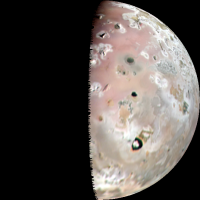
Phil Dec 31 2023, 01:03 AM StargazeInWonder Wow. My eyes watered. That first image is already ... Dec 31 2023, 01:39 AM volcanopele after fretting for a month about these images afte... Dec 31 2023, 01:52 AM StargazeInWonder When I saw the color image on missionjuno, I said,... Dec 31 2023, 02:22 AM mcaplinger Images are on missionjuno now.
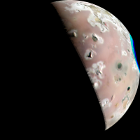
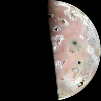
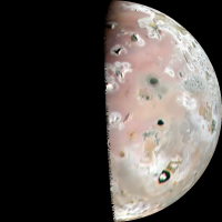
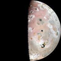
Here's the lat... Dec 31 2023, 02:28 AM Kevin Gill First pass on PJ57-22:
Io - PJ57-22 Dec 31 2023, 02:46 AM scalbers Yes this is amazing and will be interesting to add... Dec 31 2023, 02:51 AM volcanopele My take:
Dec 31 2023, 03:13 AM Hungry4info Here's the only thing I've found that vagu... Dec 31 2023, 04:05 AM volcanopele I haven't gotten that far yet but my best gues... Dec 31 2023, 04:31 AM volcanopele My new favorite volcano is visible in Jupiter Shin... Dec 31 2023, 05:03 AM volcanopele Full set of six:
Plus a nice bonus color anagly... Dec 31 2023, 06:17 AM ugordan Absolutely spectacular stuff, well worth the wait.... Dec 31 2023, 06:27 AM john_s QUOTE (volcanopele @ Dec 30 2023, 11:17 P... Dec 31 2023, 02:48 PM Webscientist A captivating time in the Juno mission around Jupi... Dec 31 2023, 03:29 PM mcaplinger QUOTE (john_s @ Dec 31 2023, 06:48 AM) Ha... Dec 31 2023, 05:35 PM Bjorn Jonsson QUOTE (john_s @ Dec 31 2023, 02:48 PM) Ha... Dec 31 2023, 05:37 PM Greenish Couldn't resist brushing off StereoPhotoMaker ... Dec 31 2023, 08:51 AM Bjorn Jonsson Congratulations to the Juno team. The high quality... Dec 31 2023, 09:01 AM Nahúm Congratulations to Juno team! There seems to b... Dec 31 2023, 09:14 AM StargazeInWonder QUOTE (Nahúm @ Dec 31 2023, 01:14 AM) Con... Dec 31 2023, 05:40 PM StargazeInWonder At the hazard of gushing too much for board rules,... Dec 31 2023, 05:47 PM Nahúm QUOTE (StargazeInWonder @ Dec 31 2023, 06... Dec 31 2023, 07:38 PM john_s The color around Loki is certainly fascinating. T... Dec 31 2023, 08:40 PM fredk There is enough information in the image itself to... Dec 31 2023, 04:42 PM scalbers A very rough / preliminary idea of how one of volc... Dec 31 2023, 06:47 PM Kevin Gill Another go using PJ57-23 with decorrelated colors ... Dec 31 2023, 07:22 PM Brian Swift Kicked off the processing pipeline this morning, e... Dec 31 2023, 09:37 PM Brian Swift And Exaggerated Color/Contrast version
Dec 31 2023, 10:05 PM StargazeInWonder There are at least three (apparent) calderas in th... Dec 31 2023, 10:37 PM scalbers Here are a some 4K maps using one image from volca... Jan 1 2024, 02:49 AM volcanopele Preliminary versions of maps. No photometric corre... Jan 1 2024, 05:47 AM scalbers A blinking animation between the second map I post... Jan 1 2024, 02:59 PM Antdoghalo The Jupitershine area really improves coverage on ... Jan 1 2024, 04:23 PM StargazeInWonder The ideal processing of the Jupitershine areas mig... Jan 1 2024, 04:55 PM scalbers Fyi I had applied the noise reduction filter in GI... Jan 1 2024, 05:15 PM volcanopele QUOTE (scalbers @ Jan 1 2024, 10:15 AM) F... Jan 1 2024, 05:58 PM StargazeInWonder To zoom in on the problem, here are magnified patc... Jan 1 2024, 09:32 PM vjkane Slightly off topic, but since this is the current ... Jan 1 2024, 05:16 PM mcaplinger QUOTE (vjkane @ Jan 1 2024, 09:16 AM) I u... Jan 1 2024, 05:37 PM scalbers Yes this may take some doing to set things up in a... Jan 1 2024, 10:00 PM mcaplinger Is there really useful color information in the Ju... Jan 1 2024, 10:11 PM volcanopele QUOTE (mcaplinger @ Jan 1 2024, 03:11 PM)... Jan 2 2024, 01:10 AM mcaplinger QUOTE (volcanopele @ Jan 1 2024, 05:10 PM... Jan 2 2024, 01:36 AM Antdoghalo Will there be an SRU image for PJ58 as well? Jan 2 2024, 12:04 AM StargazeInWonder Taking one of Jason's images and applying a 3x... Jan 2 2024, 01:19 AM volcanopele daylit map (includes images 22 to 25)
Jan 2 2024, 03:47 AM volcanopele Jupiter shine map, with and without 3x3 median smo... Jan 2 2024, 05:43 AM kymani76
I managed to extract preliminary shape model of I... Jan 2 2024, 11:44 AM Decepticon The nightside image is a wonderful bonus! Jan 2 2024, 05:50 PM kymani76
I refined Io shape model further with more image... Jan 2 2024, 10:51 PM mcaplinger The Jupiter images have been posted to missionjuno... Jan 3 2024, 02:39 AM Brian Swift QUOTE (mcaplinger @ Jan 2 2024, 06:39 PM)... Jan 4 2024, 07:35 AM Decepticon Does the next flyby cover the same region? Jan 3 2024, 05:22 AM mcaplinger QUOTE (Decepticon @ Jan 2 2024, 09:22 PM)... Jan 3 2024, 05:55 AM StargazeInWonder Fortunately, the next flyby covers almost exactly ... Jan 3 2024, 05:22 PM mcaplinger QUOTE (StargazeInWonder @ Jan 3 2024, 09... Jan 4 2024, 04:46 PM chlegrand Hello UMSF members,
Here are my first attempts fo... Jan 3 2024, 06:56 AM volcanopele Mike, I am definitely coming around to the idea th... Jan 4 2024, 04:06 PM volcanopele maybe they meant the area covered in Jupiter-shine... Jan 4 2024, 05:09 PM StargazeInWonder I'll defer fully on the question of which flyb... Jan 4 2024, 06:07 PM Bjorn Jonsson ImagePJ57_23:
North is up. The brightness of th... Jan 5 2024, 01:36 AM volcanopele For my images, I did have to set jigsaw to correct... Jan 5 2024, 02:11 AM Kevin Gill A couple attempts at the Jupiter images, all proce... Jan 5 2024, 08:05 PM Phil Stooke So the closest images... were they lost or just de... Jan 5 2024, 10:51 PM mcaplinger QUOTE (Phil Stooke @ Jan 5 2024, 02:51 PM... Jan 5 2024, 11:12 PM Phil Stooke That answers my question - imaging at closest appr... Jan 6 2024, 12:57 AM OWW QUOTE (Phil Stooke @ Jan 6 2024, 01:57 AM... Jan 8 2024, 02:30 PM scalbers Here's a try with the GIMP-GEGL noise filter o... Jan 6 2024, 08:51 PM scalbers Present version of 4K map with both daytime and ni... Jan 8 2024, 01:24 AM scalbers A blinking comparison of the new and prior maps:
Jan 8 2024, 01:33 AM Kevin Gill Family Portrait: Ganymede, Io, Europa, Callisto, a... Jan 8 2024, 04:26 PM Antdoghalo Any update on the jupitershine SRU image? Jan 24 2024, 02:36 PM kymani76 QUOTE (Antdoghalo @ Jan 24 2024, 03:36 PM... Feb 20 2024, 09:55 AM Bjorn Jonsson An approximately true color/contrast version (left... Feb 3 2024, 11:23 PM volcanopele Can you do a plot where the SRU image is one rotat... Feb 20 2024, 02:58 PM kymani76
Here is the plot as requested. One with your PJ... Feb 20 2024, 06:03 PM
Explorer1 QUOTE (Tom Tamlyn @ Oct 22 2023, 08:39 PM... Oct 23 2023, 03:34 AM StargazeInWonder The next two flybys will be close enough that Dopp... Oct 23 2023, 04:51 AM john_s I've heard that the Juno gravity data will hav... Oct 23 2023, 05:33 PM mcaplinger We're less than a week out from the Io flyby. ... Dec 23 2023, 11:22 PM volcanopele Preview images using the latest ephemeris and c-ke... Dec 24 2023, 03:11 AM mcaplinger QUOTE (volcanopele @ Dec 23 2023, 07:11 P... Dec 24 2023, 04:10 AM Antdoghalo Would have been cool to test if there was airglow ... Dec 24 2023, 01:28 PM volcanopele They can take one. I'm hoping they can get one... Dec 24 2023, 02:57 PM volcanopele
having a bit too much fun prepping for a preview... Dec 24 2023, 08:32 PM volcanopele Wow, okay, so an hour long preview video is proces... Dec 28 2023, 02:39 AM Antdoghalo https://www.youtube.com/watch?v=pLRPS9LZmn0 It fin... Dec 28 2023, 12:53 PM kymani76 Wonderful video, thank you Jason!
I also made... Dec 28 2023, 05:48 PM scalbers Just checking on the outbound portion of the flyby... Dec 30 2023, 07:55 PM mcaplinger First Io image is up on social media, e.g., https:... Dec 31 2023, 12:21 AM vjkane QUOTE (mcaplinger @ Dec 30 2023, 04:21 PM... Dec 31 2023, 12:50 AM Phil Stooke Yes, and great detail on the night side too.
Phil Dec 31 2023, 01:03 AM StargazeInWonder Wow. My eyes watered. That first image is already ... Dec 31 2023, 01:39 AM volcanopele after fretting for a month about these images afte... Dec 31 2023, 01:52 AM StargazeInWonder When I saw the color image on missionjuno, I said,... Dec 31 2023, 02:22 AM mcaplinger Images are on missionjuno now.
Here's the lat... Dec 31 2023, 02:28 AM Kevin Gill First pass on PJ57-22:
Io - PJ57-22 Dec 31 2023, 02:46 AM scalbers Yes this is amazing and will be interesting to add... Dec 31 2023, 02:51 AM volcanopele My take:
Dec 31 2023, 03:13 AM Hungry4info Here's the only thing I've found that vagu... Dec 31 2023, 04:05 AM volcanopele I haven't gotten that far yet but my best gues... Dec 31 2023, 04:31 AM volcanopele My new favorite volcano is visible in Jupiter Shin... Dec 31 2023, 05:03 AM volcanopele Full set of six:
Plus a nice bonus color anagly... Dec 31 2023, 06:17 AM ugordan Absolutely spectacular stuff, well worth the wait.... Dec 31 2023, 06:27 AM john_s QUOTE (volcanopele @ Dec 30 2023, 11:17 P... Dec 31 2023, 02:48 PM Webscientist A captivating time in the Juno mission around Jupi... Dec 31 2023, 03:29 PM mcaplinger QUOTE (john_s @ Dec 31 2023, 06:48 AM) Ha... Dec 31 2023, 05:35 PM Bjorn Jonsson QUOTE (john_s @ Dec 31 2023, 02:48 PM) Ha... Dec 31 2023, 05:37 PM Greenish Couldn't resist brushing off StereoPhotoMaker ... Dec 31 2023, 08:51 AM Bjorn Jonsson Congratulations to the Juno team. The high quality... Dec 31 2023, 09:01 AM Nahúm Congratulations to Juno team! There seems to b... Dec 31 2023, 09:14 AM StargazeInWonder QUOTE (Nahúm @ Dec 31 2023, 01:14 AM) Con... Dec 31 2023, 05:40 PM StargazeInWonder At the hazard of gushing too much for board rules,... Dec 31 2023, 05:47 PM Nahúm QUOTE (StargazeInWonder @ Dec 31 2023, 06... Dec 31 2023, 07:38 PM john_s The color around Loki is certainly fascinating. T... Dec 31 2023, 08:40 PM fredk There is enough information in the image itself to... Dec 31 2023, 04:42 PM scalbers A very rough / preliminary idea of how one of volc... Dec 31 2023, 06:47 PM Kevin Gill Another go using PJ57-23 with decorrelated colors ... Dec 31 2023, 07:22 PM Brian Swift Kicked off the processing pipeline this morning, e... Dec 31 2023, 09:37 PM Brian Swift And Exaggerated Color/Contrast version
Dec 31 2023, 10:05 PM StargazeInWonder There are at least three (apparent) calderas in th... Dec 31 2023, 10:37 PM scalbers Here are a some 4K maps using one image from volca... Jan 1 2024, 02:49 AM volcanopele Preliminary versions of maps. No photometric corre... Jan 1 2024, 05:47 AM scalbers A blinking animation between the second map I post... Jan 1 2024, 02:59 PM Antdoghalo The Jupitershine area really improves coverage on ... Jan 1 2024, 04:23 PM StargazeInWonder The ideal processing of the Jupitershine areas mig... Jan 1 2024, 04:55 PM scalbers Fyi I had applied the noise reduction filter in GI... Jan 1 2024, 05:15 PM volcanopele QUOTE (scalbers @ Jan 1 2024, 10:15 AM) F... Jan 1 2024, 05:58 PM StargazeInWonder To zoom in on the problem, here are magnified patc... Jan 1 2024, 09:32 PM vjkane Slightly off topic, but since this is the current ... Jan 1 2024, 05:16 PM mcaplinger QUOTE (vjkane @ Jan 1 2024, 09:16 AM) I u... Jan 1 2024, 05:37 PM scalbers Yes this may take some doing to set things up in a... Jan 1 2024, 10:00 PM mcaplinger Is there really useful color information in the Ju... Jan 1 2024, 10:11 PM volcanopele QUOTE (mcaplinger @ Jan 1 2024, 03:11 PM)... Jan 2 2024, 01:10 AM mcaplinger QUOTE (volcanopele @ Jan 1 2024, 05:10 PM... Jan 2 2024, 01:36 AM Antdoghalo Will there be an SRU image for PJ58 as well? Jan 2 2024, 12:04 AM StargazeInWonder Taking one of Jason's images and applying a 3x... Jan 2 2024, 01:19 AM volcanopele daylit map (includes images 22 to 25)
Jan 2 2024, 03:47 AM volcanopele Jupiter shine map, with and without 3x3 median smo... Jan 2 2024, 05:43 AM kymani76
I managed to extract preliminary shape model of I... Jan 2 2024, 11:44 AM Decepticon The nightside image is a wonderful bonus! Jan 2 2024, 05:50 PM kymani76
I refined Io shape model further with more image... Jan 2 2024, 10:51 PM mcaplinger The Jupiter images have been posted to missionjuno... Jan 3 2024, 02:39 AM Brian Swift QUOTE (mcaplinger @ Jan 2 2024, 06:39 PM)... Jan 4 2024, 07:35 AM Decepticon Does the next flyby cover the same region? Jan 3 2024, 05:22 AM mcaplinger QUOTE (Decepticon @ Jan 2 2024, 09:22 PM)... Jan 3 2024, 05:55 AM StargazeInWonder Fortunately, the next flyby covers almost exactly ... Jan 3 2024, 05:22 PM mcaplinger QUOTE (StargazeInWonder @ Jan 3 2024, 09... Jan 4 2024, 04:46 PM chlegrand Hello UMSF members,
Here are my first attempts fo... Jan 3 2024, 06:56 AM volcanopele Mike, I am definitely coming around to the idea th... Jan 4 2024, 04:06 PM volcanopele maybe they meant the area covered in Jupiter-shine... Jan 4 2024, 05:09 PM StargazeInWonder I'll defer fully on the question of which flyb... Jan 4 2024, 06:07 PM Bjorn Jonsson ImagePJ57_23:
North is up. The brightness of th... Jan 5 2024, 01:36 AM volcanopele For my images, I did have to set jigsaw to correct... Jan 5 2024, 02:11 AM Kevin Gill A couple attempts at the Jupiter images, all proce... Jan 5 2024, 08:05 PM Phil Stooke So the closest images... were they lost or just de... Jan 5 2024, 10:51 PM mcaplinger QUOTE (Phil Stooke @ Jan 5 2024, 02:51 PM... Jan 5 2024, 11:12 PM Phil Stooke That answers my question - imaging at closest appr... Jan 6 2024, 12:57 AM OWW QUOTE (Phil Stooke @ Jan 6 2024, 01:57 AM... Jan 8 2024, 02:30 PM scalbers Here's a try with the GIMP-GEGL noise filter o... Jan 6 2024, 08:51 PM scalbers Present version of 4K map with both daytime and ni... Jan 8 2024, 01:24 AM scalbers A blinking comparison of the new and prior maps:
Jan 8 2024, 01:33 AM Kevin Gill Family Portrait: Ganymede, Io, Europa, Callisto, a... Jan 8 2024, 04:26 PM Antdoghalo Any update on the jupitershine SRU image? Jan 24 2024, 02:36 PM kymani76 QUOTE (Antdoghalo @ Jan 24 2024, 03:36 PM... Feb 20 2024, 09:55 AM Bjorn Jonsson An approximately true color/contrast version (left... Feb 3 2024, 11:23 PM volcanopele Can you do a plot where the SRU image is one rotat... Feb 20 2024, 02:58 PM kymani76
Here is the plot as requested. One with your PJ... Feb 20 2024, 06:03 PM |

|
Lo-Fi Version | Time is now: 23rd May 2024 - 06:55 PM |
|
RULES AND GUIDELINES Please read the Forum Rules and Guidelines before posting. IMAGE COPYRIGHT |
OPINIONS AND MODERATION Opinions expressed on UnmannedSpaceflight.com are those of the individual posters and do not necessarily reflect the opinions of UnmannedSpaceflight.com or The Planetary Society. The all-volunteer UnmannedSpaceflight.com moderation team is wholly independent of The Planetary Society. The Planetary Society has no influence over decisions made by the UnmannedSpaceflight.com moderators. |
SUPPORT THE FORUM Unmannedspaceflight.com is funded by the Planetary Society. Please consider supporting our work and many other projects by donating to the Society or becoming a member. |
|