Juno Perijove 58, February 3, 2024 |

Juno Perijove 58, February 3, 2024 |
 Jan 4 2024, 05:21 PM Jan 4 2024, 05:21 PM
Post
#1
|
|
|
Senior Member  Group: Members Posts: 2520 Joined: 13-September 05 Member No.: 497 |
(Started a new thread to avoid cluttering up the PJ57 thread with PJ58 discussion.)
-------------------- Disclaimer: This post is based on public information only. Any opinions are my own.
|
 |
 
|
 |
|
Jan 12 2024, 10:09 PM
Post
#2
|
||
 Member Group: Members Posts: 349 Joined: 20-June 07 From: Slovenia Member No.: 2461 |
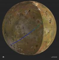
I'm not totally sure, but I believe it is possible to present above discussion in a map form. The view above shows Io as seen from Jupiter at the time of the flyby. In other words, the center of map projection is at Io's sub-Jupiter point. This means we are looking at the hemisphere illuminated by Jupiter-shine. I've used this article to estimate how much of Io's disk Juno can see at selected times. (17:49 in red, 17:49:30 in green; 17:50 in blue). I used values of 0.25, 0,265 and 0.28 respectively for f to account for the rising altitude, giving me range circles for parts of Io visible to Juno at these times. You can really see how much the coverage changes in very short time. I still have to account for Junocam FOV as I suspect not the whole visible disk fits into the camera view, but I haven't figured out how to account for that yet. And yes, there is no Jupiter-shine on the inbound track. |
|
|
|
|
|
|
Jan 12 2024, 10:24 PM
Post
#3
|
|
|
Senior Member Group: Members Posts: 2520 Joined: 13-September 05 Member No.: 497 |
QUOTE (kymani76 @ Jan 12 2024, 02:09 PM)  I still have to account for Junocam FOV as I suspect not the whole visible disk fits into the camera view, but I haven't figured out how to account for that yet. It's not easy. To do it completely correctly, you need to know the pointing of the spacecraft as a function of time. For many of these flybys, including this one, the spacecraft spin axis (Z) is pointed at Earth, which makes it a little easier. So the Junocam FOV is a locus roughly +/- 30 degrees from the XY plane and spun about the Z axis. If a point on Io is in that locus we can see it, if it's not then we can't. I could imagine sampling a full range of lat/lon, checking to see if that point was in the locus, and drawing a little X there if it was, or something similar. BTW, after much analysis I decided I couldn't take an image at 17:49, but one did fit at 17:48:30 so I took one there with TDI 12, then three images at 17:50 (TDI 12), 17:51 (TDI 2), and 17:52 (TDI 2). All RGB. 2024-034T17:32:00 RGB 6, 2 2024-034T17:39:00 RGB 2, 12 2024-034T17:48:30 RGB 12 2024-034T17:50:00 RGB 12, 2, 2 2024-034T17:53:30 RGB 12, 6 You have until Monday to change my mind  -------------------- Disclaimer: This post is based on public information only. Any opinions are my own.
|
|
|
|
 mcaplinger Juno Perijove 58 Jan 4 2024, 05:21 PM
 mcaplinger QUOTE (volcanopele @ Jan 4 2024, 09:09 AM... Jan 4 2024, 06:33 PM
 StargazeInWonder I guess to put this imagery to a rubber-meets-the-... Jan 4 2024, 07:03 PM Bjorn Jonsson From the PJ57 thread:
QUOTE (volcanopele @ J... Jan 5 2024, 01:03 AM Brian Swift QUOTE (Bjorn Jonsson @ Jan 4 2024, 05:03 ... Jan 5 2024, 03:20 AM mcaplinger QUOTE (Bjorn Jonsson @ Jan 4 2024, 05:03 ... Jan 5 2024, 03:45 AM kymani76
Map for PJ58 Io flyby from SPK. Ground track cove... Jan 5 2024, 11:18 AM MarcF I expect to see some beautiful images of Ra patera... Jan 5 2024, 05:01 PM mcaplinger My initial cut at PJ58 image timing for Io is:
20... Jan 9 2024, 12:15 AM kymani76
I updated the flyby map with new information abov... Jan 9 2024, 10:00 AM mcaplinger QUOTE (kymani76 @ Jan 9 2024, 02:00 AM) I... Jan 9 2024, 04:49 PM volcanopele A pretty decent set of observations. I might repla... Jan 9 2024, 06:19 PM mcaplinger QUOTE (volcanopele @ Jan 9 2024, 10:19 AM... Jan 9 2024, 07:00 PM kymani76
I made another visualisation of the flyby, includ... Jan 10 2024, 08:44 AM mcaplinger QUOTE (kymani76 @ Jan 10 2024, 12:44 AM) ... Jan 10 2024, 05:10 PM volcanopele for 17:49 this is what I get:
This does add cov... Jan 10 2024, 05:35 PM mcaplinger QUOTE (volcanopele @ Jan 10 2024, 09:35 A... Jan 10 2024, 06:36 PM mcaplinger QUOTE (volcanopele @ Jan 10 2024, 09:35 A... Jan 11 2024, 05:10 PM volcanopele I presumed that if the third block of four gets sh... Jan 10 2024, 10:22 PM volcanopele 17:49:30 still has Masubi in the FOV but it is muc... Jan 11 2024, 06:54 PM mcaplinger Have you compared the amount of Jupitershine in th... Jan 11 2024, 07:20 PM mcaplinger QUOTE (mcaplinger @ Jan 11 2024, 11:20 AM... Jan 11 2024, 10:15 PM volcanopele comparing 55C00035 with 57C00030 and 57C00022, I g... Jan 11 2024, 08:49 PM volcanopele Even for my simulations, I account for the JunoCam... Jan 15 2024, 07:22 PM mcaplinger For posterity, Jason's last message arrived to... Jan 16 2024, 08:47 PM kymani76
I made some progress querying SPICE. Here is what... Jan 18 2024, 08:18 PM volcanopele With the timings and TDI settings Mike provided ab... Jan 23 2024, 07:55 PM john_s Thanks! How will the resolution on Loki compa... Jan 23 2024, 10:31 PM volcanopele The resolution will roughly match JNCE_2023364_57C... Jan 23 2024, 10:53 PM mcaplinger Apparently there is going to be a live event with ... Feb 2 2024, 10:01 PM volcanopele Thanks for the heads up Mike. I did let me D&D... Feb 3 2024, 04:35 PM volcanopele Full images aren't up yet, but the green filte... Feb 4 2024, 04:38 AM StargazeInWonder Here's an effort to align the Loki imagery in ... Feb 4 2024, 06:23 AM volcanopele BTW, not the first time we’ve seen specular ... Feb 4 2024, 06:37 AM Bjorn Jonsson Wow! This is a beautiful image of Loki, far mo... Feb 4 2024, 01:32 PM john_s New Horizons also got a nice view of strong specul... Feb 4 2024, 06:09 PM mcaplinger Io images are up on missionjuno now. https://www.... Feb 4 2024, 11:05 PM volcanopele First pair of images complete:
Feb 4 2024, 11:06 PM StargazeInWonder Wow, the specular effects at Loki vary tremendousl... Feb 4 2024, 11:57 PM Brian Swift PJ58_24 closest approach image from 1499.3 km alti... Feb 4 2024, 11:38 PM volcanopele
First attempt at the second Jupiter shine image.... Feb 5 2024, 12:13 AM Brian Swift PJ58_25, altitude 2493.8 km, Jupiter-shine illumin... Feb 5 2024, 12:25 AM Brian Swift PJ58_25 again, stretched, to bring out hint of plu... Feb 5 2024, 12:27 AM volcanopele Looks like Masubi lives! Feb 5 2024, 01:45 AM Bjorn Jonsson These images are awesome. They must be by far the ... Feb 5 2024, 03:18 AM volcanopele
Improved versions using a global control network Feb 5 2024, 05:47 AM Daniele_bianchino_Italy sorry if the question has already been posted,
Wh... Feb 5 2024, 08:46 AM StargazeInWonder According to previous temperature measurements, th... Feb 5 2024, 09:59 AM john_s Yes, wonderful images. It's interesting that ... Feb 5 2024, 03:20 PM ngunn Wonderful images of a wonderful world. Thanks to ... Feb 5 2024, 04:25 PM mcaplinger QUOTE (ngunn @ Feb 5 2024, 08:25 AM) Jaso... Feb 5 2024, 05:06 PM volcanopele Just two different methods of processing the data.... Feb 5 2024, 09:04 PM Bjorn Jonsson A map-projected comparison of images PJ57_24 and P... Feb 5 2024, 10:20 PM antipode Has anyone managed to actually spot an impact crat... Feb 6 2024, 03:42 AM Phil Stooke We just recently had a first suggestion of an impa... Feb 6 2024, 03:58 AM StargazeInWonder "Twenty-kilometer diameter craters are made b... Feb 6 2024, 05:57 PM Brian Swift PJ58_23 with plume. Jupiter-shine illuminated.
Feb 6 2024, 06:47 AM Bjorn Jonsson This is an updated plot of the values I use for co... Feb 8 2024, 01:40 AM StargazeInWonder I keep mulling this over and had the following spe... Feb 8 2024, 02:57 AM mcaplinger QUOTE (StargazeInWonder @ Feb 7 2024, 06... Feb 8 2024, 04:44 PM tau A further processing of volcanopele's image of... Feb 8 2024, 07:34 AM kymani76
Here's my version of performing upscale and P... Feb 8 2024, 11:54 PM tau Brian Swift's image from post #44 of Jupiter-s... Feb 13 2024, 02:59 PM Holder of the Two Leashes Wen JIRAM images? Feb 13 2024, 06:18 PM mcaplinger QUOTE (Holder of the Two Leashes @ Feb 13 202... Feb 13 2024, 06:49 PM volcanopele The PDS release calendar is here: https://pds.nasa... Feb 14 2024, 04:46 PM Bjorn Jonsson This is an animation showing a simulation of Io... Feb 20 2024, 12:14 AM
StargazeInWonder I guess to put this imagery to a rubber-meets-the-... Jan 4 2024, 07:03 PM Bjorn Jonsson From the PJ57 thread:
QUOTE (volcanopele @ J... Jan 5 2024, 01:03 AM Brian Swift QUOTE (Bjorn Jonsson @ Jan 4 2024, 05:03 ... Jan 5 2024, 03:20 AM mcaplinger QUOTE (Bjorn Jonsson @ Jan 4 2024, 05:03 ... Jan 5 2024, 03:45 AM kymani76
Map for PJ58 Io flyby from SPK. Ground track cove... Jan 5 2024, 11:18 AM MarcF I expect to see some beautiful images of Ra patera... Jan 5 2024, 05:01 PM mcaplinger My initial cut at PJ58 image timing for Io is:
20... Jan 9 2024, 12:15 AM kymani76
I updated the flyby map with new information abov... Jan 9 2024, 10:00 AM mcaplinger QUOTE (kymani76 @ Jan 9 2024, 02:00 AM) I... Jan 9 2024, 04:49 PM volcanopele A pretty decent set of observations. I might repla... Jan 9 2024, 06:19 PM mcaplinger QUOTE (volcanopele @ Jan 9 2024, 10:19 AM... Jan 9 2024, 07:00 PM kymani76
I made another visualisation of the flyby, includ... Jan 10 2024, 08:44 AM mcaplinger QUOTE (kymani76 @ Jan 10 2024, 12:44 AM) ... Jan 10 2024, 05:10 PM volcanopele for 17:49 this is what I get:
This does add cov... Jan 10 2024, 05:35 PM mcaplinger QUOTE (volcanopele @ Jan 10 2024, 09:35 A... Jan 10 2024, 06:36 PM mcaplinger QUOTE (volcanopele @ Jan 10 2024, 09:35 A... Jan 11 2024, 05:10 PM volcanopele I presumed that if the third block of four gets sh... Jan 10 2024, 10:22 PM volcanopele 17:49:30 still has Masubi in the FOV but it is muc... Jan 11 2024, 06:54 PM mcaplinger Have you compared the amount of Jupitershine in th... Jan 11 2024, 07:20 PM mcaplinger QUOTE (mcaplinger @ Jan 11 2024, 11:20 AM... Jan 11 2024, 10:15 PM volcanopele comparing 55C00035 with 57C00030 and 57C00022, I g... Jan 11 2024, 08:49 PM volcanopele Even for my simulations, I account for the JunoCam... Jan 15 2024, 07:22 PM mcaplinger For posterity, Jason's last message arrived to... Jan 16 2024, 08:47 PM kymani76
I made some progress querying SPICE. Here is what... Jan 18 2024, 08:18 PM volcanopele With the timings and TDI settings Mike provided ab... Jan 23 2024, 07:55 PM john_s Thanks! How will the resolution on Loki compa... Jan 23 2024, 10:31 PM volcanopele The resolution will roughly match JNCE_2023364_57C... Jan 23 2024, 10:53 PM mcaplinger Apparently there is going to be a live event with ... Feb 2 2024, 10:01 PM volcanopele Thanks for the heads up Mike. I did let me D&D... Feb 3 2024, 04:35 PM volcanopele Full images aren't up yet, but the green filte... Feb 4 2024, 04:38 AM StargazeInWonder Here's an effort to align the Loki imagery in ... Feb 4 2024, 06:23 AM volcanopele BTW, not the first time we’ve seen specular ... Feb 4 2024, 06:37 AM Bjorn Jonsson Wow! This is a beautiful image of Loki, far mo... Feb 4 2024, 01:32 PM john_s New Horizons also got a nice view of strong specul... Feb 4 2024, 06:09 PM mcaplinger Io images are up on missionjuno now. https://www.... Feb 4 2024, 11:05 PM volcanopele First pair of images complete:
Feb 4 2024, 11:06 PM StargazeInWonder Wow, the specular effects at Loki vary tremendousl... Feb 4 2024, 11:57 PM Brian Swift PJ58_24 closest approach image from 1499.3 km alti... Feb 4 2024, 11:38 PM volcanopele
First attempt at the second Jupiter shine image.... Feb 5 2024, 12:13 AM Brian Swift PJ58_25, altitude 2493.8 km, Jupiter-shine illumin... Feb 5 2024, 12:25 AM Brian Swift PJ58_25 again, stretched, to bring out hint of plu... Feb 5 2024, 12:27 AM volcanopele Looks like Masubi lives! Feb 5 2024, 01:45 AM Bjorn Jonsson These images are awesome. They must be by far the ... Feb 5 2024, 03:18 AM volcanopele
Improved versions using a global control network Feb 5 2024, 05:47 AM Daniele_bianchino_Italy sorry if the question has already been posted,
Wh... Feb 5 2024, 08:46 AM StargazeInWonder According to previous temperature measurements, th... Feb 5 2024, 09:59 AM john_s Yes, wonderful images. It's interesting that ... Feb 5 2024, 03:20 PM ngunn Wonderful images of a wonderful world. Thanks to ... Feb 5 2024, 04:25 PM mcaplinger QUOTE (ngunn @ Feb 5 2024, 08:25 AM) Jaso... Feb 5 2024, 05:06 PM volcanopele Just two different methods of processing the data.... Feb 5 2024, 09:04 PM Bjorn Jonsson A map-projected comparison of images PJ57_24 and P... Feb 5 2024, 10:20 PM antipode Has anyone managed to actually spot an impact crat... Feb 6 2024, 03:42 AM Phil Stooke We just recently had a first suggestion of an impa... Feb 6 2024, 03:58 AM StargazeInWonder "Twenty-kilometer diameter craters are made b... Feb 6 2024, 05:57 PM Brian Swift PJ58_23 with plume. Jupiter-shine illuminated.
Feb 6 2024, 06:47 AM Bjorn Jonsson This is an updated plot of the values I use for co... Feb 8 2024, 01:40 AM StargazeInWonder I keep mulling this over and had the following spe... Feb 8 2024, 02:57 AM mcaplinger QUOTE (StargazeInWonder @ Feb 7 2024, 06... Feb 8 2024, 04:44 PM tau A further processing of volcanopele's image of... Feb 8 2024, 07:34 AM kymani76
Here's my version of performing upscale and P... Feb 8 2024, 11:54 PM tau Brian Swift's image from post #44 of Jupiter-s... Feb 13 2024, 02:59 PM Holder of the Two Leashes Wen JIRAM images? Feb 13 2024, 06:18 PM mcaplinger QUOTE (Holder of the Two Leashes @ Feb 13 202... Feb 13 2024, 06:49 PM volcanopele The PDS release calendar is here: https://pds.nasa... Feb 14 2024, 04:46 PM Bjorn Jonsson This is an animation showing a simulation of Io... Feb 20 2024, 12:14 AM |

|
Lo-Fi Version | Time is now: 20th June 2024 - 11:37 PM |
|
RULES AND GUIDELINES Please read the Forum Rules and Guidelines before posting. IMAGE COPYRIGHT |
OPINIONS AND MODERATION Opinions expressed on UnmannedSpaceflight.com are those of the individual posters and do not necessarily reflect the opinions of UnmannedSpaceflight.com or The Planetary Society. The all-volunteer UnmannedSpaceflight.com moderation team is wholly independent of The Planetary Society. The Planetary Society has no influence over decisions made by the UnmannedSpaceflight.com moderators. |
SUPPORT THE FORUM Unmannedspaceflight.com is funded by the Planetary Society. Please consider supporting our work and many other projects by donating to the Society or becoming a member. |
|