Perseverance Route Map |

Perseverance Route Map |
 Feb 22 2021, 10:16 PM Feb 22 2021, 10:16 PM
Post
#1
|
||
|
Solar System Cartographer  Group: Members Posts: 10191 Joined: 5-April 05 From: Canada Member No.: 227 |
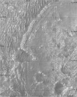
Now we are down safely I am starting a map thread. Everything that happens during 2021 will be covered in my still-in-progress atlas, so I have to make the maps for that and everyone can follow as they evolve.
Let me know if any feature names start to show up. Preliminary map even though not much has happened yet. But if you look closely you will see something, even now. Phil
-------------------- ... because the Solar System ain't gonna map itself.
Also to be found posting similar content on https://mastodon.social/@PhilStooke Maps for download (free PD: https://upload.wikimedia.org/wikipedia/comm...Cartography.pdf NOTE: everything created by me which I post on UMSF is considered to be in the public domain (NOT CC, public domain) |
|
 |
 
|
|
 |
|
Apr 20 2024, 02:42 PM
Post
#2
|
||
|
Solar System Cartographer Group: Members Posts: 10191 Joined: 5-April 05 From: Canada Member No.: 227 |
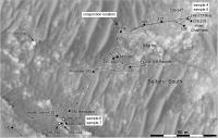
Hi. I think you mean this one.
Phil
-------------------- ... because the Solar System ain't gonna map itself.
Also to be found posting similar content on https://mastodon.social/@PhilStooke Maps for download (free PD: https://upload.wikimedia.org/wikipedia/comm...Cartography.pdf NOTE: everything created by me which I post on UMSF is considered to be in the public domain (NOT CC, public domain) |
|
|
|
|
|
|
Apr 20 2024, 06:24 PM
Post
#3
|
|
 Member Group: Members Posts: 125 Joined: 19-November 14 From: Québec Member No.: 7339 |
Thank you very much Phil for this map which will be very useful to me indeed. The roads are very clear and well demarcated (Thank you!). I am also looking for the following map whose path is located between Sols 335 and 352 to disentangle the distances which are poorly defined on the NASA rover tracking maps (Sols 340-341). And did the rover really travel 314.13 meters on Sol 351?
https://science.nasa.gov/mission/mars-2020-...e/location-map/ ----------------------------------------------------------------------------------------------------------------------------------- Merci beaucoup Phil pour cette carte qui va me être très utile effectivement. Les route sont très claire et bien départagée (Merci !). Je cherche également la carte suivante dont le trajet est situé entre les Sols 335 et 352 pour démêler les distances qui sont mal défini sur les cartes du suivit du rover de la Nasa (les Sols 340-341). Et le rover a-t-il vraiment parcourus 314,13 mètre au Sol 351 ? https://science.nasa.gov/mission/mars-2020-...e/location-map/ -------------------- |
|
|
|
 Phil Stooke Perseverance Route Map Feb 22 2021, 10:16 PM
 Glevesque I finally realized my mistake. These are different... Apr 23 2024, 09:46 PM Glevesque I don't know if any of you know the diameter o... May 3 2024, 02:58 PM tau The areas from where Perseverances Mastcam-Z and S... May 5 2024, 11:13 AM tau QUOTE (Glevesque @ May 3 2024, 04:58 PM) ... May 5 2024, 01:48 PM Glevesque Thanks tau May 5 2024, 03:29 PM tau QUOTE (Glevesque @ May 3 2024, 04:58 PM) ... May 8 2024, 04:06 PM
 mcaplinger QUOTE (tau @ May 8 2024, 09:06 AM) ...the... May 8 2024, 04:26 PM Glevesque A big thank you tau. I will adjust my narrative in... May 8 2024, 05:56 PM
 |

|
Lo-Fi Version | Time is now: 9th June 2024 - 04:50 AM |
|
RULES AND GUIDELINES Please read the Forum Rules and Guidelines before posting. IMAGE COPYRIGHT |
OPINIONS AND MODERATION Opinions expressed on UnmannedSpaceflight.com are those of the individual posters and do not necessarily reflect the opinions of UnmannedSpaceflight.com or The Planetary Society. The all-volunteer UnmannedSpaceflight.com moderation team is wholly independent of The Planetary Society. The Planetary Society has no influence over decisions made by the UnmannedSpaceflight.com moderators. |
SUPPORT THE FORUM Unmannedspaceflight.com is funded by the Planetary Society. Please consider supporting our work and many other projects by donating to the Society or becoming a member. |
|