Comanche |

Comanche |
 Dec 16 2005, 05:35 PM Dec 16 2005, 05:35 PM
Post
#1
|
||
 Senior Member  Group: Members Posts: 1887 Joined: 20-November 04 From: Iowa Member No.: 110 |
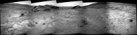
Spirit has arrived at Comanche

|
|
 |
 
|
|
 |
|
Dec 17 2005, 03:48 AM
Post
#2
|
|
|
Senior Member Group: Members Posts: 3008 Joined: 30-October 04 Member No.: 105 |
Wondrous! Thwack it with the IDD ASAP. I see fine laminations... sedimentary or clastic?
As I've mentioned I think we'll find that many of these "layered outcrops" are on the same page, stratigraphically. I've taken the Sol 671-675 panorama by mhoward, leveled the horizon and drew what what I presume to be be horizontal lines between outcrops. It seems that these outcrops are at the same elevation. FWIW, I might be in left field or up the creek since it's difficult to eyeball "level". --Bill -------------------- |
|
|
|
 alan Comanche Dec 16 2005, 05:35 PM
 mhoward I wonder if we'll complete the approach this w... Dec 16 2005, 06:29 PM Bill Harris I'm looking at Comanche as being a preview of ... Dec 16 2005, 07:17 PM
 dilo What a view! Dec 16 2005, 10:45 PM john_s QUOTE (dilo @ Dec 16 2005, 10:45 PM)What a vi... Dec 16 2005, 11:33 PM dilo Sol694 detail (3 PanCam R2 shots): Dec 17 2005, 01:58 PM Mizar Hi... a newbie here...
This is an another amazing ... Dec 16 2005, 11:43 PM lyford Wait a minute... what's that over there betwee... Dec 17 2005, 12:30 AM Nix What a great chunk of rock!
Comanche_crop ... Dec 17 2005, 01:39 AM SFJCody Wow! Look at the texture of this thing! Al... Dec 17 2005, 09:46 AM Nix sol 694_Comanche L257 false-color
Spirit, show ... Dec 17 2005, 11:42 AM edstrick Heh...Nix posted a version of the Comanche pic whi... Dec 17 2005, 11:55 AM mars loon QUOTE (alan @ Dec 16 2005, 05:35 PM)Spirit ha... Dec 17 2005, 02:03 PM Bill Harris These images will thrill and captivate you.
From ... Dec 18 2005, 02:00 AM mars loon QUOTE (Bill Harris @ Dec 18 2005, 02:00 AM)Th... Dec 18 2005, 02:50 AM gpurcell Looks a bit like Pot-of-Gold. Dec 18 2005, 04:18 AM dilo Thanks Bill! Dec 18 2005, 07:13 AM Nix QUOTE (mars loon @ Dec 17 2005, 04:03 PM)Marc... Dec 18 2005, 08:48 AM ustrax 'Thank you very nice' Nico!
As with Do... Dec 19 2005, 09:39 AM mars loon QUOTE (NIX @ Dec 18 2005, 08:48 AM)
Comanche,... Dec 19 2005, 06:49 PM Sacha Martinetti-Lévy About Nix's anaglyph
QUOTE (mars loon @ ... Dec 19 2005, 08:31 PM mars loon QUOTE (Sacha Martinetti-Lévy @ Dec 19 20... Dec 20 2005, 04:04 PM edstrick These are from the approach to Comanche, not of Co... Dec 19 2005, 10:34 AM edstrick There's some pretty wild layering in one of th... Dec 19 2005, 10:47 AM jvandriel Here is the complete 360 degree panoramic view at ... Dec 19 2005, 10:54 AM Nix that IS a great view!
Nico Dec 19 2005, 12:19 PM Tesheiner I'm not a geologist, but imho the rock outcrop... Dec 19 2005, 04:15 PM ustrax In position...
http://qt.exploratorium.edu/mars/s... Dec 19 2005, 04:55 PM RNeuhaus Uhhh, what impressive climbing, the rover driver h... Dec 19 2005, 05:01 PM Bill Harris QUOTE I'm not a geologist, but imho the rock o... Dec 19 2005, 05:15 PM Toma B Beautifull wiew of Comanche and ultreya...
S... Dec 19 2005, 05:29 PM Bob Shaw QUOTE (Toma B @ Dec 19 2005, 06:29 PM)Beautif... Dec 19 2005, 05:46 PM mhoward RE: Comanche Dec 19 2005, 06:41 PM odave Just before lunch, I was about to post a request f... Dec 19 2005, 07:05 PM mhoward QUOTE (odave @ Dec 19 2005, 07:05 PM)I hope m... Dec 19 2005, 07:58 PM odave Here's what I get for raiding my kid's Chr... Dec 20 2005, 03:20 AM dilo A stitch of two Sol693 PanCam.. Dec 20 2005, 06:46 AM dilo QUOTE (dilo @ Dec 20 2005, 06:46 AM)A stitch ... Dec 20 2005, 07:05 AM Tesheiner QUOTE (odave @ Dec 20 2005, 04:20 AM)Here... Dec 20 2005, 04:32 PM odave QUOTE (Tesheiner @ Dec 20 2005, 11:32 AM)You ... Dec 20 2005, 04:45 PM Marz If the rocks of the inner basin have a higher abun... Dec 20 2005, 05:14 PM Airbag Quite an interesting item behind Spirit; looks lik... Dec 20 2005, 07:17 PM CosmicRocker Get youself a nice pair of Proview glasses here:
h... Dec 20 2005, 06:22 AM deglr6328 QUOTE (CosmicRocker @ Dec 20 2005, 06:22 AM)G... Dec 20 2005, 06:49 AM Gonzz I raided mine from the Spy Kids DVD! they look... Dec 20 2005, 07:23 AM MaxSt Mine are from Sports Illustrated Swimsuit Edition.... Dec 20 2005, 08:19 AM Tesheiner Just playing around with those last deck navcams f... Dec 20 2005, 01:25 PM AndyG QUOTE (Tesheiner @ Dec 20 2005, 01:25 PM)Just... Dec 20 2005, 03:02 PM mhoward MMB doesn't do very well close to the rover, b... Dec 20 2005, 03:43 PM ustrax QUOTE (mhoward @ Dec 20 2005, 03:43 PM)MMB do... Dec 20 2005, 03:46 PM mhoward QUOTE (ustrax @ Dec 20 2005, 03:46 PM)I'm... Dec 20 2005, 04:21 PM ustrax QUOTE (mhoward @ Dec 20 2005, 04:21 PM)Ustrax... Dec 20 2005, 04:43 PM ustrax QUOTE (ustrax @ Dec 20 2005, 04:43 PM)mhoward... Dec 20 2005, 08:36 PM dilo Again on deck navcams from sol 697/8: polar and ve... Dec 20 2005, 10:24 PM CosmicRocker QUOTE (MaxSt @ Dec 20 2005, 02:19 AM)Mine are... Dec 21 2005, 05:11 AM Nix Glad you like the anaglyph! If I find the time... Dec 21 2005, 07:16 AM mars loon QUOTE (NIX @ Dec 21 2005, 07:16 AM)Glad you l... Dec 21 2005, 01:14 PM jvandriel Spirit working on Comanche.
A panoramic view take... Dec 21 2005, 09:55 AM jvandriel How about this one.
Spirit working on Comanche. T... Dec 21 2005, 03:28 PM Phil Stooke Dilo - nice polar and vertical views.
I'd lik... Dec 21 2005, 06:03 PM dilo QUOTE (Phil Stooke @ Dec 21 2005, 06:03 PM)Di... Dec 21 2005, 11:45 PM Reckless A Comanche MI stitch
Reckless Dec 21 2005, 08:07 PM Nix A lot of small detail.
Thanks reckless, nice mosa... Dec 21 2005, 08:17 PM Astro0 Hi everyone.
First time posting for me.
Been readi... Dec 21 2005, 11:04 PM dilo Very nice, Astro0!
Not so distant from officia... Dec 21 2005, 11:34 PM mhoward From Sol 695: Dec 22 2005, 12:16 AM CosmicRocker jvandriel: Nice work. That's a perspective w... Dec 22 2005, 03:31 AM jvandriel Spirit looking back at Husband Hill and Haskin Rid... Dec 22 2005, 08:54 PM alan panorama of Comanche from sol 698
Dec 23 2005, 02:59 AM mhoward Nice mosaic. FWIW, here is the Navcam context, plu... Dec 23 2005, 04:38 AM jvandriel Here are some pancam L2 panoramic views of Comanch... Dec 23 2005, 05:57 PM jvandriel and the second one from Sol 698.
jvandriel Dec 23 2005, 05:58 PM Shaka Aloha!
I couldn't help noticing some ... Dec 24 2005, 02:51 AM Bill Harris Yep, them be sparklies. They are unusual here sinc... Dec 24 2005, 03:12 AM CosmicRocker I noticed them, too. I think Bill is correct. We... Dec 24 2005, 06:01 AM Shaka QUOTE I noticed them, too. I think Bill is correct... Dec 24 2005, 07:27 PM CosmicRocker If the light is right, you might expect to see spe... Dec 25 2005, 07:11 AM Bill Harris I doubt that the "crystal" is a salt. W... Dec 25 2005, 08:13 AM abalone QUOTE (Bill Harris @ Dec 25 2005, 07:13 PM)I ... Dec 25 2005, 11:08 AM mhoward Pancam coverage to the northeast:
Happy Holid... Dec 25 2005, 05:08 PM Phil Stooke I'm returning to this thread to add a few pola... Jan 1 2006, 05:23 PM Phil Stooke Here's sol 693. I really look forward to seei... Jan 1 2006, 05:26 PM
dilo What a view! Dec 16 2005, 10:45 PM john_s QUOTE (dilo @ Dec 16 2005, 10:45 PM)What a vi... Dec 16 2005, 11:33 PM dilo Sol694 detail (3 PanCam R2 shots): Dec 17 2005, 01:58 PM Mizar Hi... a newbie here...
This is an another amazing ... Dec 16 2005, 11:43 PM lyford Wait a minute... what's that over there betwee... Dec 17 2005, 12:30 AM Nix What a great chunk of rock!
Comanche_crop ... Dec 17 2005, 01:39 AM SFJCody Wow! Look at the texture of this thing! Al... Dec 17 2005, 09:46 AM Nix sol 694_Comanche L257 false-color
Spirit, show ... Dec 17 2005, 11:42 AM edstrick Heh...Nix posted a version of the Comanche pic whi... Dec 17 2005, 11:55 AM mars loon QUOTE (alan @ Dec 16 2005, 05:35 PM)Spirit ha... Dec 17 2005, 02:03 PM Bill Harris These images will thrill and captivate you.
From ... Dec 18 2005, 02:00 AM mars loon QUOTE (Bill Harris @ Dec 18 2005, 02:00 AM)Th... Dec 18 2005, 02:50 AM gpurcell Looks a bit like Pot-of-Gold. Dec 18 2005, 04:18 AM dilo Thanks Bill! Dec 18 2005, 07:13 AM Nix QUOTE (mars loon @ Dec 17 2005, 04:03 PM)Marc... Dec 18 2005, 08:48 AM ustrax 'Thank you very nice' Nico!
As with Do... Dec 19 2005, 09:39 AM mars loon QUOTE (NIX @ Dec 18 2005, 08:48 AM)
Comanche,... Dec 19 2005, 06:49 PM Sacha Martinetti-Lévy About Nix's anaglyph
QUOTE (mars loon @ ... Dec 19 2005, 08:31 PM mars loon QUOTE (Sacha Martinetti-Lévy @ Dec 19 20... Dec 20 2005, 04:04 PM edstrick These are from the approach to Comanche, not of Co... Dec 19 2005, 10:34 AM edstrick There's some pretty wild layering in one of th... Dec 19 2005, 10:47 AM jvandriel Here is the complete 360 degree panoramic view at ... Dec 19 2005, 10:54 AM Nix that IS a great view!
Nico Dec 19 2005, 12:19 PM Tesheiner I'm not a geologist, but imho the rock outcrop... Dec 19 2005, 04:15 PM ustrax In position...
http://qt.exploratorium.edu/mars/s... Dec 19 2005, 04:55 PM RNeuhaus Uhhh, what impressive climbing, the rover driver h... Dec 19 2005, 05:01 PM Bill Harris QUOTE I'm not a geologist, but imho the rock o... Dec 19 2005, 05:15 PM Toma B Beautifull wiew of Comanche and ultreya...
S... Dec 19 2005, 05:29 PM Bob Shaw QUOTE (Toma B @ Dec 19 2005, 06:29 PM)Beautif... Dec 19 2005, 05:46 PM mhoward RE: Comanche Dec 19 2005, 06:41 PM odave Just before lunch, I was about to post a request f... Dec 19 2005, 07:05 PM mhoward QUOTE (odave @ Dec 19 2005, 07:05 PM)I hope m... Dec 19 2005, 07:58 PM odave Here's what I get for raiding my kid's Chr... Dec 20 2005, 03:20 AM dilo A stitch of two Sol693 PanCam.. Dec 20 2005, 06:46 AM dilo QUOTE (dilo @ Dec 20 2005, 06:46 AM)A stitch ... Dec 20 2005, 07:05 AM Tesheiner QUOTE (odave @ Dec 20 2005, 04:20 AM)Here... Dec 20 2005, 04:32 PM odave QUOTE (Tesheiner @ Dec 20 2005, 11:32 AM)You ... Dec 20 2005, 04:45 PM Marz If the rocks of the inner basin have a higher abun... Dec 20 2005, 05:14 PM Airbag Quite an interesting item behind Spirit; looks lik... Dec 20 2005, 07:17 PM CosmicRocker Get youself a nice pair of Proview glasses here:
h... Dec 20 2005, 06:22 AM deglr6328 QUOTE (CosmicRocker @ Dec 20 2005, 06:22 AM)G... Dec 20 2005, 06:49 AM Gonzz I raided mine from the Spy Kids DVD! they look... Dec 20 2005, 07:23 AM MaxSt Mine are from Sports Illustrated Swimsuit Edition.... Dec 20 2005, 08:19 AM Tesheiner Just playing around with those last deck navcams f... Dec 20 2005, 01:25 PM AndyG QUOTE (Tesheiner @ Dec 20 2005, 01:25 PM)Just... Dec 20 2005, 03:02 PM mhoward MMB doesn't do very well close to the rover, b... Dec 20 2005, 03:43 PM ustrax QUOTE (mhoward @ Dec 20 2005, 03:43 PM)MMB do... Dec 20 2005, 03:46 PM mhoward QUOTE (ustrax @ Dec 20 2005, 03:46 PM)I'm... Dec 20 2005, 04:21 PM ustrax QUOTE (mhoward @ Dec 20 2005, 04:21 PM)Ustrax... Dec 20 2005, 04:43 PM ustrax QUOTE (ustrax @ Dec 20 2005, 04:43 PM)mhoward... Dec 20 2005, 08:36 PM dilo Again on deck navcams from sol 697/8: polar and ve... Dec 20 2005, 10:24 PM CosmicRocker QUOTE (MaxSt @ Dec 20 2005, 02:19 AM)Mine are... Dec 21 2005, 05:11 AM Nix Glad you like the anaglyph! If I find the time... Dec 21 2005, 07:16 AM mars loon QUOTE (NIX @ Dec 21 2005, 07:16 AM)Glad you l... Dec 21 2005, 01:14 PM jvandriel Spirit working on Comanche.
A panoramic view take... Dec 21 2005, 09:55 AM jvandriel How about this one.
Spirit working on Comanche. T... Dec 21 2005, 03:28 PM Phil Stooke Dilo - nice polar and vertical views.
I'd lik... Dec 21 2005, 06:03 PM dilo QUOTE (Phil Stooke @ Dec 21 2005, 06:03 PM)Di... Dec 21 2005, 11:45 PM Reckless A Comanche MI stitch
Reckless Dec 21 2005, 08:07 PM Nix A lot of small detail.
Thanks reckless, nice mosa... Dec 21 2005, 08:17 PM Astro0 Hi everyone.
First time posting for me.
Been readi... Dec 21 2005, 11:04 PM dilo Very nice, Astro0!
Not so distant from officia... Dec 21 2005, 11:34 PM mhoward From Sol 695: Dec 22 2005, 12:16 AM CosmicRocker jvandriel: Nice work. That's a perspective w... Dec 22 2005, 03:31 AM jvandriel Spirit looking back at Husband Hill and Haskin Rid... Dec 22 2005, 08:54 PM alan panorama of Comanche from sol 698
Dec 23 2005, 02:59 AM mhoward Nice mosaic. FWIW, here is the Navcam context, plu... Dec 23 2005, 04:38 AM jvandriel Here are some pancam L2 panoramic views of Comanch... Dec 23 2005, 05:57 PM jvandriel and the second one from Sol 698.
jvandriel Dec 23 2005, 05:58 PM Shaka Aloha!
I couldn't help noticing some ... Dec 24 2005, 02:51 AM Bill Harris Yep, them be sparklies. They are unusual here sinc... Dec 24 2005, 03:12 AM CosmicRocker I noticed them, too. I think Bill is correct. We... Dec 24 2005, 06:01 AM Shaka QUOTE I noticed them, too. I think Bill is correct... Dec 24 2005, 07:27 PM CosmicRocker If the light is right, you might expect to see spe... Dec 25 2005, 07:11 AM Bill Harris I doubt that the "crystal" is a salt. W... Dec 25 2005, 08:13 AM abalone QUOTE (Bill Harris @ Dec 25 2005, 07:13 PM)I ... Dec 25 2005, 11:08 AM mhoward Pancam coverage to the northeast:
Happy Holid... Dec 25 2005, 05:08 PM Phil Stooke I'm returning to this thread to add a few pola... Jan 1 2006, 05:23 PM Phil Stooke Here's sol 693. I really look forward to seei... Jan 1 2006, 05:26 PM |

|
Lo-Fi Version | Time is now: 26th September 2024 - 02:51 PM |
|
RULES AND GUIDELINES Please read the Forum Rules and Guidelines before posting. IMAGE COPYRIGHT |
OPINIONS AND MODERATION Opinions expressed on UnmannedSpaceflight.com are those of the individual posters and do not necessarily reflect the opinions of UnmannedSpaceflight.com or The Planetary Society. The all-volunteer UnmannedSpaceflight.com moderation team is wholly independent of The Planetary Society. The Planetary Society has no influence over decisions made by the UnmannedSpaceflight.com moderators. |
SUPPORT THE FORUM Unmannedspaceflight.com is funded by the Planetary Society. Please consider supporting our work and many other projects by donating to the Society or becoming a member. |
|