Spirit Route Map, Small and Large Scales |

Spirit Route Map, Small and Large Scales |
 Feb 17 2004, 01:07 AM Feb 17 2004, 01:07 AM
Post
#201
|
|
|
Founder  Group: Chairman Posts: 14433 Joined: 8-February 04 Member No.: 1 |
 
|
 |
 
|
 |
|
Jan 11 2006, 10:14 AM
Post
#202
|
||
|
Senior Member Group: Moderator Posts: 4279 Joined: 19-April 05 From: .br at .es Member No.: 253 |
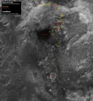
Route map, up to sol 719.
|
|
|
|
|
|
|
Jan 11 2006, 02:07 PM
Post
#203
|
||
 Member Group: Members Posts: 136 Joined: 13-October 05 From: Malibu, CA Member No.: 527 |
[quote=Tesheiner,Jan 11 2006, 03:14 AM]
Route map, up to sol 719. - - Tesh, I'm beginning to worry that we'll not spend much time at Home Plate... I'm speculating that it will take at least (and that's moving fast) another 7 to 10 days to get to Home Plate - and with little time for doing much probing, another 8 to 10 days to get to a North facing slope. Do you (or anyone) see a route fast enough to get us to Home Plate and to safe wintering ground, in time? In the link below, I've used a piece of your Route Map to illustrate daily drives - for perhaps 14 days+... and you can see where we may run rather short of time. 380KB image I'm beginning to wonder if Home Plate will be left for the springtime... 
Attached thumbnail(s)
|
|
|
|
|
|
 djellison Spirit Route Map Feb 17 2004, 01:07 AM
 general To reach McCool Hill, Spirit has to take the route... Jan 4 2006, 09:45 AM
 Shaka QUOTE (general @ Jan 3 2006, 11:45 PM)To reac... Jan 4 2006, 07:16 PM general QUOTE (Shaka @ Jan 4 2006, 08:16 PM)Whoa, who... Jan 4 2006, 07:31 PM Shaka QUOTE (general @ Jan 4 2006, 09:31 AM)
Thanke... Jan 4 2006, 08:31 PM general QUOTE (Shaka @ Jan 4 2006, 09:31 PM)Thankee, ... Jan 4 2006, 09:18 PM Tesheiner Could be, IF the intention was to go direct to McC... Jan 4 2006, 09:51 AM alan spirit locations 680-713
Jan 4 2006, 10:42 PM Shaka QUOTE (alan @ Jan 4 2006, 12:42 PM)spirit loc... Jan 4 2006, 11:20 PM akuo QUOTE (Shaka @ Jan 4 2006, 11:20 PM)Ah, at la... Jan 4 2006, 11:23 PM Shaka QUOTE (akuo @ Jan 4 2006, 01:23 PM)No! It... Jan 4 2006, 11:30 PM akuo QUOTE (Shaka @ Jan 4 2006, 11:30 PM) JE... Jan 4 2006, 11:32 PM jamescanvin QUOTE (akuo @ Jan 5 2006, 10:32 AM)Just to ma... Jan 5 2006, 01:53 AM nprev How about Rectangle Ridge, for the formation's... Jan 4 2006, 11:28 PM Tesheiner Route map updated up to sol 713.
(351k)
I'v... Jan 5 2006, 10:26 AM djellison I've tried to compare Alan-is-Lost with Tesh-M... Jan 5 2006, 10:38 AM john_s QUOTE (djellison @ Jan 5 2006, 10:38 AM)I... Jan 5 2006, 05:23 PM general Beautiful new traverse maps:
http://marsrovers.jpl... Jan 5 2006, 05:09 PM djellison RE: Spirit Route Map Jan 5 2006, 05:12 PM ustrax Double quoting Doug... Jan 5 2006, 05:21 PM djellison I've sent a polite email to Dr Li ( he of MER ... Jan 5 2006, 05:40 PM Toma B QUOTE (djellison @ Jan 5 2006, 08:40 PM)...If... Jan 5 2006, 06:02 PM RNeuhaus Somewhat close, it is a bi-dimensional map. I am c... Jan 5 2006, 08:03 PM alan another drive day
Jan 5 2006, 10:05 PM Shaka QUOTE (alan @ Jan 5 2006, 12:05 PM)another dr... Jan 6 2006, 01:42 AM SigurRosFan Alan, is this image exaggerated version? Jan 5 2006, 10:20 PM alan Yes, it's a 2x vertical exaggeration. It makes... Jan 5 2006, 10:35 PM SigurRosFan Alan, could you post the non-processed image (with... Jan 6 2006, 11:55 AM alan With or without the verticle exaggeration? Jan 6 2006, 12:45 PM SigurRosFan Just without exaggeration. Jan 6 2006, 01:32 PM alan RE: Spirit Route Map Jan 6 2006, 01:52 PM SigurRosFan Thanks! Jan 6 2006, 01:53 PM MaxSt here's what I've got: Jan 7 2006, 06:12 AM CosmicRocker The contours on that OSU route map seem to be sugg... Jan 7 2006, 06:39 AM abalone QUOTE (CosmicRocker @ Jan 7 2006, 05:39 PM)Th... Jan 7 2006, 12:06 PM RNeuhaus QUOTE (CosmicRocker @ Jan 7 2006, 01:39 AM)Th... Jan 9 2006, 06:38 PM Bill Harris QUOTE here's what I've got:
Very good... Jan 7 2006, 10:08 AM djellison No - there's a 'ripping' to the stereo... Jan 7 2006, 12:18 PM alan Spirit drove to the next dune
More drives coming ... Jan 8 2006, 12:16 AM dot.dk alan - love your maps. But I think the black numbe... Jan 8 2006, 01:16 AM dilo dot/alan, I love too these maps , we should cont... Jan 8 2006, 08:29 AM Phil Stooke Here's a preview of something I'm working ... Jan 8 2006, 09:19 PM Tesheiner Spirit route map, updated up to sol 717 (714 by Di... Jan 9 2006, 11:17 AM general New traverse maps:
http://marsrovers.jpl.nasa.gov/... Jan 9 2006, 05:48 PM Tesheiner QUOTE (Tesheiner @ Jan 9 2006, 12:17 PM)Spiri... Jan 9 2006, 09:11 PM sattrackpro Well - I ~tried~ to remove the attachment, Tesh - ... Jan 11 2006, 02:15 PM vikingmars Nice speculation !
If I were a MER geologis... Jan 18 2006, 02:15 PM Tesheiner Your proposed path seems reasonable; there are oth... Jan 11 2006, 02:41 PM akuo Can't see us being in that much of a hurry. Yo... Jan 11 2006, 02:55 PM sattrackpro QUOTE (akuo @ Jan 11 2006, 07:55 AM)Can't... Jan 12 2006, 02:26 AM Mongo QUOTE (sattrackpro @ Jan 12 2006, 02:26 AM)Th... Jan 12 2006, 04:28 AM CosmicRocker I missed some earlier responses to one of my comme... Jan 12 2006, 05:37 AM RNeuhaus QUOTE (CosmicRocker @ Jan 12 2006, 12:37 AM)R... Jan 12 2006, 03:43 PM Bill Harris Tom, big replys are OK with me; it takes as much t... Jan 12 2006, 11:43 AM Phil Stooke MOLA is far too low in resolution to help make a t... Jan 12 2006, 01:54 PM MaxSt Spirit is here, right? Jan 16 2006, 12:54 AM RNeuhaus QUOTE (MaxSt @ Jan 15 2006, 07:54 PM)Spirit i... Jan 16 2006, 02:54 AM Tesheiner I think MaxSt is right, Rodolfo.
The arrow is poin... Jan 16 2006, 09:47 AM vikingmars OOOPS : here is the modified picture with alternat... Jan 18 2006, 04:57 PM RNeuhaus Never know what the JPL want to tranverse. We have... Jan 18 2006, 05:00 PM Shaka QUOTE (RNeuhaus @ Jan 18 2006, 07:00 AM)Never... Jan 18 2006, 10:06 PM Tesheiner An updated route map, up to sol 727.
(574k) Jan 19 2006, 10:39 AM sattrackpro QUOTE (Tesheiner @ Jan 19 2006, 03:39 AM)An u... Jan 19 2006, 12:18 PM djellison The most recent drive was a very good one imho - c... Jan 19 2006, 12:30 PM akuo We're out of the sand now (nobody has made a n... Jan 19 2006, 12:41 PM Tesheiner I think that's a good example of "one ste... Jan 19 2006, 01:55 PM RNeuhaus I am thinking that the solution for Spirit to over... Jan 19 2006, 04:07 PM Tesheiner Spirit route map, after sol 728.
(574k) Jan 20 2006, 10:10 AM alan Updated to sol 730
Jan 22 2006, 04:05 PM Phil Stooke This image is the foreground of Dilo's excelle... Jan 22 2006, 04:32 PM Shaka QUOTE (Phil Stooke @ Jan 22 2006, 06:32 AM)Th... Jan 22 2006, 07:13 PM Tesheiner Route map, including sol 730's driving.
(574... Jan 23 2006, 10:44 AM CosmicRocker I have been wanting to do a Spirit route map on an... Jan 24 2006, 06:11 AM Shaka QUOTE (CosmicRocker @ Jan 23 2006, 08:11 PM)I... Jan 24 2006, 07:58 PM Zeke4ther QUOTE (CosmicRocker @ Jan 24 2006, 02:11 AM)I... Jan 25 2006, 12:08 AM mars loon QUOTE (CosmicRocker @ Jan 24 2006, 06:11 AM)I... Jan 25 2006, 01:40 AM general Updated traverse maps:
http://marsrovers.jpl.nasa.... Jan 24 2006, 08:36 AM djellison Just for fun, prepared for my talk tomorrow, this ... Jan 24 2006, 04:04 PM dvandorn QUOTE (djellison @ Jan 24 2006, 10:04 AM)Just... Jan 25 2006, 02:41 AM Burmese RE: Spirit Route map
Googled Mitcheltree Ridge, c... Jan 24 2006, 04:13 PM Oersted That is very sad, but what a wonderful lasting tri... Jan 24 2006, 07:17 PM Shaka QUOTE (Burmese @ Jan 24 2006, 06:13 AM)RE: Sp... Jan 24 2006, 07:52 PM djellison Actually - this is 100% true and accurate - if you... Jan 25 2006, 02:44 AM Shaka QUOTE (djellison @ Jan 24 2006, 04:44 PM)Actu... Jan 25 2006, 02:52 AM alan short drive tosol (732)
Jan 25 2006, 03:51 AM Shaka QUOTE (alan @ Jan 24 2006, 05:51 PM)short dri... Jan 25 2006, 07:07 AM CosmicRocker Thanks for the kind and helpful comments regarding... Jan 25 2006, 06:04 AM Shaka QUOTE (CosmicRocker @ Jan 24 2006, 08:04 PM)... Jan 25 2006, 07:19 AM Tesheiner QUOTE (CosmicRocker @ Jan 25 2006, 07:04 AM)A... Jan 25 2006, 09:23 AM MaxSt QUOTE (CosmicRocker @ Jan 25 2006, 02:04 AM)T... Jan 25 2006, 09:53 AM Tesheiner Route map, updated after sol 733's driving.
... Jan 25 2006, 11:36 AM alan RE: Spirit Route Map Jan 25 2006, 01:36 PM Tesheiner New update including sol 734.
(502k) Jan 26 2006, 10:37 AM Tesheiner ... and new traverse maps (for yestersol) at the J... Jan 26 2006, 11:45 AM sattrackpro QUOTE (Tesheiner @ Jan 26 2006, 04:45 AM)... ... Jan 26 2006, 12:35 PM Toma B QUOTE (Tesheiner @ Jan 26 2006, 02:45 PM)I... Jan 26 2006, 01:33 PM Bill Harris >I'm wondering if I should (or not) continu... Jan 26 2006, 02:17 PM akuo Tesh,
They are probably just copying your and al... Jan 26 2006, 02:35 PM
Shaka QUOTE (general @ Jan 3 2006, 11:45 PM)To reac... Jan 4 2006, 07:16 PM general QUOTE (Shaka @ Jan 4 2006, 08:16 PM)Whoa, who... Jan 4 2006, 07:31 PM Shaka QUOTE (general @ Jan 4 2006, 09:31 AM)
Thanke... Jan 4 2006, 08:31 PM general QUOTE (Shaka @ Jan 4 2006, 09:31 PM)Thankee, ... Jan 4 2006, 09:18 PM Tesheiner Could be, IF the intention was to go direct to McC... Jan 4 2006, 09:51 AM alan spirit locations 680-713
Jan 4 2006, 10:42 PM Shaka QUOTE (alan @ Jan 4 2006, 12:42 PM)spirit loc... Jan 4 2006, 11:20 PM akuo QUOTE (Shaka @ Jan 4 2006, 11:20 PM)Ah, at la... Jan 4 2006, 11:23 PM Shaka QUOTE (akuo @ Jan 4 2006, 01:23 PM)No! It... Jan 4 2006, 11:30 PM akuo QUOTE (Shaka @ Jan 4 2006, 11:30 PM) JE... Jan 4 2006, 11:32 PM jamescanvin QUOTE (akuo @ Jan 5 2006, 10:32 AM)Just to ma... Jan 5 2006, 01:53 AM nprev How about Rectangle Ridge, for the formation's... Jan 4 2006, 11:28 PM Tesheiner Route map updated up to sol 713.
(351k)
I'v... Jan 5 2006, 10:26 AM djellison I've tried to compare Alan-is-Lost with Tesh-M... Jan 5 2006, 10:38 AM john_s QUOTE (djellison @ Jan 5 2006, 10:38 AM)I... Jan 5 2006, 05:23 PM general Beautiful new traverse maps:
http://marsrovers.jpl... Jan 5 2006, 05:09 PM djellison RE: Spirit Route Map Jan 5 2006, 05:12 PM ustrax Double quoting Doug... Jan 5 2006, 05:21 PM djellison I've sent a polite email to Dr Li ( he of MER ... Jan 5 2006, 05:40 PM Toma B QUOTE (djellison @ Jan 5 2006, 08:40 PM)...If... Jan 5 2006, 06:02 PM RNeuhaus Somewhat close, it is a bi-dimensional map. I am c... Jan 5 2006, 08:03 PM alan another drive day
Jan 5 2006, 10:05 PM Shaka QUOTE (alan @ Jan 5 2006, 12:05 PM)another dr... Jan 6 2006, 01:42 AM SigurRosFan Alan, is this image exaggerated version? Jan 5 2006, 10:20 PM alan Yes, it's a 2x vertical exaggeration. It makes... Jan 5 2006, 10:35 PM SigurRosFan Alan, could you post the non-processed image (with... Jan 6 2006, 11:55 AM alan With or without the verticle exaggeration? Jan 6 2006, 12:45 PM SigurRosFan Just without exaggeration. Jan 6 2006, 01:32 PM alan RE: Spirit Route Map Jan 6 2006, 01:52 PM SigurRosFan Thanks! Jan 6 2006, 01:53 PM MaxSt here's what I've got: Jan 7 2006, 06:12 AM CosmicRocker The contours on that OSU route map seem to be sugg... Jan 7 2006, 06:39 AM abalone QUOTE (CosmicRocker @ Jan 7 2006, 05:39 PM)Th... Jan 7 2006, 12:06 PM RNeuhaus QUOTE (CosmicRocker @ Jan 7 2006, 01:39 AM)Th... Jan 9 2006, 06:38 PM Bill Harris QUOTE here's what I've got:
Very good... Jan 7 2006, 10:08 AM djellison No - there's a 'ripping' to the stereo... Jan 7 2006, 12:18 PM alan Spirit drove to the next dune
More drives coming ... Jan 8 2006, 12:16 AM dot.dk alan - love your maps. But I think the black numbe... Jan 8 2006, 01:16 AM dilo dot/alan, I love too these maps , we should cont... Jan 8 2006, 08:29 AM Phil Stooke Here's a preview of something I'm working ... Jan 8 2006, 09:19 PM Tesheiner Spirit route map, updated up to sol 717 (714 by Di... Jan 9 2006, 11:17 AM general New traverse maps:
http://marsrovers.jpl.nasa.gov/... Jan 9 2006, 05:48 PM Tesheiner QUOTE (Tesheiner @ Jan 9 2006, 12:17 PM)Spiri... Jan 9 2006, 09:11 PM sattrackpro Well - I ~tried~ to remove the attachment, Tesh - ... Jan 11 2006, 02:15 PM vikingmars Nice speculation !
If I were a MER geologis... Jan 18 2006, 02:15 PM Tesheiner Your proposed path seems reasonable; there are oth... Jan 11 2006, 02:41 PM akuo Can't see us being in that much of a hurry. Yo... Jan 11 2006, 02:55 PM sattrackpro QUOTE (akuo @ Jan 11 2006, 07:55 AM)Can't... Jan 12 2006, 02:26 AM Mongo QUOTE (sattrackpro @ Jan 12 2006, 02:26 AM)Th... Jan 12 2006, 04:28 AM CosmicRocker I missed some earlier responses to one of my comme... Jan 12 2006, 05:37 AM RNeuhaus QUOTE (CosmicRocker @ Jan 12 2006, 12:37 AM)R... Jan 12 2006, 03:43 PM Bill Harris Tom, big replys are OK with me; it takes as much t... Jan 12 2006, 11:43 AM Phil Stooke MOLA is far too low in resolution to help make a t... Jan 12 2006, 01:54 PM MaxSt Spirit is here, right? Jan 16 2006, 12:54 AM RNeuhaus QUOTE (MaxSt @ Jan 15 2006, 07:54 PM)Spirit i... Jan 16 2006, 02:54 AM Tesheiner I think MaxSt is right, Rodolfo.
The arrow is poin... Jan 16 2006, 09:47 AM vikingmars OOOPS : here is the modified picture with alternat... Jan 18 2006, 04:57 PM RNeuhaus Never know what the JPL want to tranverse. We have... Jan 18 2006, 05:00 PM Shaka QUOTE (RNeuhaus @ Jan 18 2006, 07:00 AM)Never... Jan 18 2006, 10:06 PM Tesheiner An updated route map, up to sol 727.
(574k) Jan 19 2006, 10:39 AM sattrackpro QUOTE (Tesheiner @ Jan 19 2006, 03:39 AM)An u... Jan 19 2006, 12:18 PM djellison The most recent drive was a very good one imho - c... Jan 19 2006, 12:30 PM akuo We're out of the sand now (nobody has made a n... Jan 19 2006, 12:41 PM Tesheiner I think that's a good example of "one ste... Jan 19 2006, 01:55 PM RNeuhaus I am thinking that the solution for Spirit to over... Jan 19 2006, 04:07 PM Tesheiner Spirit route map, after sol 728.
(574k) Jan 20 2006, 10:10 AM alan Updated to sol 730
Jan 22 2006, 04:05 PM Phil Stooke This image is the foreground of Dilo's excelle... Jan 22 2006, 04:32 PM Shaka QUOTE (Phil Stooke @ Jan 22 2006, 06:32 AM)Th... Jan 22 2006, 07:13 PM Tesheiner Route map, including sol 730's driving.
(574... Jan 23 2006, 10:44 AM CosmicRocker I have been wanting to do a Spirit route map on an... Jan 24 2006, 06:11 AM Shaka QUOTE (CosmicRocker @ Jan 23 2006, 08:11 PM)I... Jan 24 2006, 07:58 PM Zeke4ther QUOTE (CosmicRocker @ Jan 24 2006, 02:11 AM)I... Jan 25 2006, 12:08 AM mars loon QUOTE (CosmicRocker @ Jan 24 2006, 06:11 AM)I... Jan 25 2006, 01:40 AM general Updated traverse maps:
http://marsrovers.jpl.nasa.... Jan 24 2006, 08:36 AM djellison Just for fun, prepared for my talk tomorrow, this ... Jan 24 2006, 04:04 PM dvandorn QUOTE (djellison @ Jan 24 2006, 10:04 AM)Just... Jan 25 2006, 02:41 AM Burmese RE: Spirit Route map
Googled Mitcheltree Ridge, c... Jan 24 2006, 04:13 PM Oersted That is very sad, but what a wonderful lasting tri... Jan 24 2006, 07:17 PM Shaka QUOTE (Burmese @ Jan 24 2006, 06:13 AM)RE: Sp... Jan 24 2006, 07:52 PM djellison Actually - this is 100% true and accurate - if you... Jan 25 2006, 02:44 AM Shaka QUOTE (djellison @ Jan 24 2006, 04:44 PM)Actu... Jan 25 2006, 02:52 AM alan short drive tosol (732)
Jan 25 2006, 03:51 AM Shaka QUOTE (alan @ Jan 24 2006, 05:51 PM)short dri... Jan 25 2006, 07:07 AM CosmicRocker Thanks for the kind and helpful comments regarding... Jan 25 2006, 06:04 AM Shaka QUOTE (CosmicRocker @ Jan 24 2006, 08:04 PM)... Jan 25 2006, 07:19 AM Tesheiner QUOTE (CosmicRocker @ Jan 25 2006, 07:04 AM)A... Jan 25 2006, 09:23 AM MaxSt QUOTE (CosmicRocker @ Jan 25 2006, 02:04 AM)T... Jan 25 2006, 09:53 AM Tesheiner Route map, updated after sol 733's driving.
... Jan 25 2006, 11:36 AM alan RE: Spirit Route Map Jan 25 2006, 01:36 PM Tesheiner New update including sol 734.
(502k) Jan 26 2006, 10:37 AM Tesheiner ... and new traverse maps (for yestersol) at the J... Jan 26 2006, 11:45 AM sattrackpro QUOTE (Tesheiner @ Jan 26 2006, 04:45 AM)... ... Jan 26 2006, 12:35 PM Toma B QUOTE (Tesheiner @ Jan 26 2006, 02:45 PM)I... Jan 26 2006, 01:33 PM Bill Harris >I'm wondering if I should (or not) continu... Jan 26 2006, 02:17 PM akuo Tesh,
They are probably just copying your and al... Jan 26 2006, 02:35 PM |

|
Lo-Fi Version | Time is now: 6th June 2024 - 02:04 AM |
|
RULES AND GUIDELINES Please read the Forum Rules and Guidelines before posting. IMAGE COPYRIGHT |
OPINIONS AND MODERATION Opinions expressed on UnmannedSpaceflight.com are those of the individual posters and do not necessarily reflect the opinions of UnmannedSpaceflight.com or The Planetary Society. The all-volunteer UnmannedSpaceflight.com moderation team is wholly independent of The Planetary Society. The Planetary Society has no influence over decisions made by the UnmannedSpaceflight.com moderators. |
SUPPORT THE FORUM Unmannedspaceflight.com is funded by the Planetary Society. Please consider supporting our work and many other projects by donating to the Society or becoming a member. |
|