First data from Venus Express ! |

First data from Venus Express ! |
 Apr 13 2006, 03:22 PM Apr 13 2006, 03:22 PM
Post
#1
|
|
 Member  Group: Members Posts: 370 Joined: 12-September 05 From: France Member No.: 495 |
Unexpected detail in first-ever Venus south pole images
http://www.esa.int/SPECIALS/Venus_Express/SEMUTYNFGLE_0.html |
 |
 
|
 |
|
Apr 13 2006, 04:24 PM
Post
#2
|
|
 Senior Member Group: Members Posts: 2530 Joined: 20-April 05 Member No.: 321 |
Good stuff. Kudos to the team for successful operations and a quick first release.
I'm curious as to the wavelengths in the dayside image. It's probably stretched beyond "human" RGB to show that much detail, but it would be fantastic to have a multispectral dataset and sate some curiosity about what a "true" color spacecraft image of Venus would look like. VEx will answer this question as well as one could expect. The IR nightside makes me wonder about the prospects of seeing the surface through the cloud layers. That's a whole lot of cloud signal. Maybe greater temporal coverage will show us the surface in peeks here and there. Also, other IR may show the surface signal better. I'm surprised how the UV image looks -- quite different from the Pioneer images. Lots of calibration questions. |
|
|
|
|
Apr 13 2006, 04:55 PM
Post
#3
|
|
|
Member Group: Members Posts: 370 Joined: 12-September 05 From: France Member No.: 495 |
QUOTE (JRehling @ Apr 13 2006, 06:24 PM)  Good stuff. Kudos to the team for successful operations and a quick first release. We just have to hope that the next releases will be as quick as the first one. However, given the PR history and what was available for the VOI, it is probably only a dream 
|
|
|
|
|
Apr 13 2006, 05:37 PM
Post
#4
|
|
|
Member Group: Members Posts: 109 Joined: 25-November 04 From: Dublin, Ireland Member No.: 113 |
Anyone here smart enough to work out the lat/lon gridlines for these first images? Presumably a half decent astronomy programme would at least tell where the subsolar point was on Venus @ say 9:07 UT on the 11th..
|
|
|
|
|
Apr 13 2006, 06:33 PM
Post
#5
|
|
|
Senior Member Group: Members Posts: 2530 Joined: 20-April 05 Member No.: 321 |
Well, since the axial inclination is only 3 degrees, you can count on the apparent pole always being pretty close to the actual pole. There's only one real degree of freedom in the subsolar point.
|
|
|
|
|
Apr 13 2006, 08:27 PM
Post
#6
|
||
 Senior Member Group: Members Posts: 2492 Joined: 15-January 05 From: center Italy Member No.: 150 |
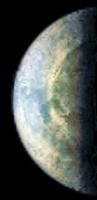
UV map seems to show surface details, but this should be only my impression (atmosphere should be more transparent in IR and visible features do not match with radar maps around south pole...).
This is a small, naif combination of visible + UV image (former was veirated toward red while latter was detail/contrast enhanced). -------------------- I always think before posting! - Marco -
|
|
|
|
|
|
 Rakhir First data from Venus Express ! Apr 13 2006, 03:22 PM
 Julius The deepsest features visible are estimated at 55 ... Apr 13 2006, 09:23 PM
 JRehling UV shouldn't ever show surface detail, I don... Apr 14 2006, 01:11 AM BruceMoomaw Nope, UV NEVER punches through to the surface -- b... Apr 14 2006, 01:48 AM deglr6328 Even if the atmosphere were cloud-free I suspect t... Apr 14 2006, 05:08 AM elakdawalla I got some more info out of Kevin Baines about the... Apr 14 2006, 10:41 PM RNeuhaus QUOTE (elakdawalla @ Apr 14 2006, 05:41 P... Apr 15 2006, 01:01 AM 4th rock from the sun QUOTE (elakdawalla @ Apr 14 2006, 11:41 P... Apr 16 2006, 12:32 AM BruceMoomaw Not at all -- no radar on this one. However, VIRT... Apr 15 2006, 02:25 AM RNeuhaus I was not aware of Planet Fourier Spectometer (PFS... Apr 15 2006, 01:29 PM Rakhir QUOTE (RNeuhaus @ Apr 15 2006, 03:29 PM) ... Apr 15 2006, 01:34 PM Decepticon Did anyone catch the Venus Express TV Special on S... Apr 15 2006, 04:39 PM Sunspot http://news.bbc.co.uk/1/hi/sci/tech/6041570.stm
S... Oct 11 2006, 10:01 PM helvick QUOTE (Sunspot @ Oct 11 2006, 11:01 PM) .... Oct 11 2006, 10:28 PM djellison Well - stuff should start hitting the PDS soon....... Oct 11 2006, 10:30 PM Rakhir A new press release for VEX but just two images ... Oct 13 2006, 01:06 PM elakdawalla Two more images and one more movie have dribbled o... Nov 9 2006, 07:16 PM MarkL Well it's a fairly boring mission from my poin... Nov 13 2006, 03:41 AM Sunspot Anyone see the recent Sky at Night special on Venu... Nov 13 2006, 09:48 AM ngunn QUOTE (Sunspot @ Nov 13 2006, 09:48 AM) S... Nov 13 2006, 09:57 AM ustrax Hot! Hot! Hot! Dec 14 2006, 09:46 AM djellison Yup - I was watching very closely.....did you spot... Nov 13 2006, 09:54 AM elakdawalla In case ustrax wasn't clear, there is a new ... Dec 14 2006, 05:23 PM volcanopele Nice write-up about this on your blog, Emily. How... Dec 18 2006, 10:48 PM Phil Stooke Yes, the Magellan map is modelled temperature base... Dec 19 2006, 02:00 AM djellison QUOTE (Phil Stooke @ Dec 19 2006, 02:00 A... Dec 19 2006, 08:39 AM scalbers QUOTE (Phil Stooke @ Dec 19 2006, 02:00 A... Dec 20 2006, 04:35 PM edstrick The trick will be to minimize interference from va... Dec 19 2006, 09:42 AM remcook QUOTE But to me it looks like the second map shows... Dec 19 2006, 09:56 AM elakdawalla QUOTE (volcanopele @ Dec 18 2006, 02:48 P... Dec 19 2006, 05:43 PM Phil Stooke The VIRTIS map from ESA is labelled with negative ... Dec 20 2006, 05:37 PM edstrick "... Curse the backwards rotation of Venus... Dec 21 2006, 08:06 AM
JRehling UV shouldn't ever show surface detail, I don... Apr 14 2006, 01:11 AM BruceMoomaw Nope, UV NEVER punches through to the surface -- b... Apr 14 2006, 01:48 AM deglr6328 Even if the atmosphere were cloud-free I suspect t... Apr 14 2006, 05:08 AM elakdawalla I got some more info out of Kevin Baines about the... Apr 14 2006, 10:41 PM RNeuhaus QUOTE (elakdawalla @ Apr 14 2006, 05:41 P... Apr 15 2006, 01:01 AM 4th rock from the sun QUOTE (elakdawalla @ Apr 14 2006, 11:41 P... Apr 16 2006, 12:32 AM BruceMoomaw Not at all -- no radar on this one. However, VIRT... Apr 15 2006, 02:25 AM RNeuhaus I was not aware of Planet Fourier Spectometer (PFS... Apr 15 2006, 01:29 PM Rakhir QUOTE (RNeuhaus @ Apr 15 2006, 03:29 PM) ... Apr 15 2006, 01:34 PM Decepticon Did anyone catch the Venus Express TV Special on S... Apr 15 2006, 04:39 PM Sunspot http://news.bbc.co.uk/1/hi/sci/tech/6041570.stm
S... Oct 11 2006, 10:01 PM helvick QUOTE (Sunspot @ Oct 11 2006, 11:01 PM) .... Oct 11 2006, 10:28 PM djellison Well - stuff should start hitting the PDS soon....... Oct 11 2006, 10:30 PM Rakhir A new press release for VEX but just two images ... Oct 13 2006, 01:06 PM elakdawalla Two more images and one more movie have dribbled o... Nov 9 2006, 07:16 PM MarkL Well it's a fairly boring mission from my poin... Nov 13 2006, 03:41 AM Sunspot Anyone see the recent Sky at Night special on Venu... Nov 13 2006, 09:48 AM ngunn QUOTE (Sunspot @ Nov 13 2006, 09:48 AM) S... Nov 13 2006, 09:57 AM ustrax Hot! Hot! Hot! Dec 14 2006, 09:46 AM djellison Yup - I was watching very closely.....did you spot... Nov 13 2006, 09:54 AM elakdawalla In case ustrax wasn't clear, there is a new ... Dec 14 2006, 05:23 PM volcanopele Nice write-up about this on your blog, Emily. How... Dec 18 2006, 10:48 PM Phil Stooke Yes, the Magellan map is modelled temperature base... Dec 19 2006, 02:00 AM djellison QUOTE (Phil Stooke @ Dec 19 2006, 02:00 A... Dec 19 2006, 08:39 AM scalbers QUOTE (Phil Stooke @ Dec 19 2006, 02:00 A... Dec 20 2006, 04:35 PM edstrick The trick will be to minimize interference from va... Dec 19 2006, 09:42 AM remcook QUOTE But to me it looks like the second map shows... Dec 19 2006, 09:56 AM elakdawalla QUOTE (volcanopele @ Dec 18 2006, 02:48 P... Dec 19 2006, 05:43 PM Phil Stooke The VIRTIS map from ESA is labelled with negative ... Dec 20 2006, 05:37 PM edstrick "... Curse the backwards rotation of Venus... Dec 21 2006, 08:06 AM |

|
Lo-Fi Version | Time is now: 23rd September 2024 - 06:13 AM |
|
RULES AND GUIDELINES Please read the Forum Rules and Guidelines before posting. IMAGE COPYRIGHT |
OPINIONS AND MODERATION Opinions expressed on UnmannedSpaceflight.com are those of the individual posters and do not necessarily reflect the opinions of UnmannedSpaceflight.com or The Planetary Society. The all-volunteer UnmannedSpaceflight.com moderation team is wholly independent of The Planetary Society. The Planetary Society has no influence over decisions made by the UnmannedSpaceflight.com moderators. |
SUPPORT THE FORUM Unmannedspaceflight.com is funded by the Planetary Society. Please consider supporting our work and many other projects by donating to the Society or becoming a member. |
|