Third HSRC Release!, Includes map-projected calibrated images |

Third HSRC Release!, Includes map-projected calibrated images |
 Apr 26 2006, 04:21 AM Apr 26 2006, 04:21 AM
Post
#1
|
|
|
Newbie  Group: Validating Posts: 17 Joined: 25-April 05 From: Pilsen, CZ, EU Member No.: 363 |
ESA released new set of HRSC images from orbits 1225 and 1863, which are map projected and radiometrically calibrated. At this moment you have to get them through the PSA interface
A color composite of a stripe of Meridiani Planum (includes Victoria) can be found here (2MB) |
 |
 
|
 |
|
Apr 27 2006, 07:50 PM
Post
#2
|
||
|
Founder Group: Chairman Posts: 14434 Joined: 8-February 04 Member No.: 1 |
oooo- pretty
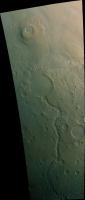
Orbit 648, nIR, G and B, not calibrated, but just adjust to look 'nice'  Doug
Attached thumbnail(s)
|
|
|
|
|
|
|
Apr 27 2006, 08:29 PM
Post
#3
|
|
 Senior Member Group: Members Posts: 2488 Joined: 17-April 05 From: Glasgow, Scotland, UK Member No.: 239 |
Doug:
About time, too! Happy mining! Bob Shaw -------------------- Remember: Time Flies like the wind - but Fruit Flies like bananas!
|
|
|
|
 jaywee Third HSRC Release! Apr 26 2006, 04:21 AM
 dilo QUOTE (jaywee @ Apr 26 2006, 04:21 AM) A ... Apr 26 2006, 07:21 AM
 jaywee Actually, it's just simple color composite - e... Apr 26 2006, 07:37 AM dilo Perhaps not intentional, but channel shift around ... Apr 26 2006, 08:55 AM dilo ...and this crater is even more intriguing:
(3D ... Apr 26 2006, 09:28 AM slinted As with the calibrated MER images, there are radia... Apr 26 2006, 03:27 PM Nix Great work -as always, Daniel
The larger ice s... Apr 26 2006, 05:54 PM djellison BJORN - img2png has another 'requriement' ... Apr 26 2006, 06:32 PM slinted Thanks Nix, Doug!
Doug: classical interface, ... Apr 26 2006, 06:39 PM Nix Man I'm enjoying these.. Keep the candy coming... Apr 26 2006, 08:41 PM djellison Just getting stuff via the RSSD and I can see your... Apr 27 2006, 06:12 PM djellison You know how some MER mosaics are large....
The G... Apr 27 2006, 06:36 PM babakm QUOTE (djellison @ Apr 27 2006, 06:36 PM)... Apr 27 2006, 07:48 PM Nix I'm getting that interface too now, yet where ... Apr 27 2006, 06:49 PM djellison The middle part of that huge 70k tall Gusev observ... Apr 27 2006, 08:15 PM djellison I'm struggling to find meridiani obs using lat... Apr 27 2006, 08:32 PM jaywee QUOTE (djellison @ Apr 27 2006, 10:15 PM)... Apr 27 2006, 10:43 PM djellison 1087, 1154, 1096 - all polar obs with nIR, G, B - ... Apr 28 2006, 07:55 AM slinted Nix: those first couple were just me looking up th... Apr 28 2006, 08:54 AM djellison "Kid in Candy Store" T-Shirts now availa... Apr 28 2006, 09:33 AM djellison There is a graph somewhere that plots 'Doug Pr... Apr 28 2006, 10:05 AM djellison Here's some interesting stuff....
A volcano (... Apr 28 2006, 11:59 AM SigurRosFan Doug, great image of Pavonis Mons. Too easy.
Yum... Apr 28 2006, 01:02 PM djellison You win....a metaphorical cookie
Do you realise... Apr 28 2006, 01:03 PM SigurRosFan Thank you sooo much.
My favorite is Pollack with... Apr 28 2006, 01:10 PM djellison You noticed that one has SIX DD's on it...SIX ... Apr 28 2006, 01:23 PM SigurRosFan QUOTE You noticed that one has SIX DD's on itN... Apr 28 2006, 02:15 PM djellison Actually - I'm going to pitch for more like 12... Apr 28 2006, 02:28 PM djellison Anyone noticed the utterly CRAP flatfielding of th... Apr 28 2006, 02:43 PM paxdan QUOTE (djellison @ Apr 28 2006, 03:43 PM)... Apr 28 2006, 03:08 PM djellison If I said what I really though, I'd end up ban... Apr 28 2006, 03:10 PM SigurRosFan Thanks for pointing out the dusty whirlwinds. Apr 28 2006, 03:26 PM djellison Ooops - thought I'd get the ND3 of the early G... Apr 28 2006, 03:49 PM jaywee QUOTE (djellison @ Apr 28 2006, 05:49 PM)... Apr 28 2006, 05:40 PM elakdawalla Just have to toss in a "wow" here -- the... Apr 28 2006, 06:04 PM tedstryk Wow...this is incredible! Apr 28 2006, 09:16 PM Phil Stooke Really nice stuff. Well done everybody.
Phil Apr 28 2006, 11:43 PM djellison A bit of Val.Mar joy before bed
Doug Apr 28 2006, 11:44 PM djellison The map interface for the PSA is crappy, and the c... Apr 29 2006, 01:54 PM djellison Emily will have some goodies to show you in the no... May 2 2006, 11:55 AM elakdawalla Duly blogged; these images are fabulous! Than... May 4 2006, 01:19 AM slinted The images are top notch, but the dust devil movie... May 4 2006, 11:21 AM djellison Wonder if I squeeze a paper out of it?
ANyway - m... May 4 2006, 03:18 PM remcook great job! this is so cool
yay to more publi... May 4 2006, 04:23 PM DDAVIS QUOTE (remcook @ May 4 2006, 04:23 PM) gr... May 4 2006, 06:07 PM djellison Here - http://pds.jpl.nasa.gov/tools/software_down... May 4 2006, 06:19 PM jaywee Doug,
I just can't stress enough how magnific... May 5 2006, 07:52 PM djellison Yup - via the psa you can get to 1800andsomething
... May 5 2006, 08:35 PM slinted I got a reply from the HRSC data processing manage... Jul 20 2006, 08:41 PM djellison Nice and simple then
Doug Jul 20 2006, 08:56 PM Malmer Dont forget to throw salt thrice over your left sh... Jul 22 2006, 08:15 AM Phil Stooke Here's a recent Phobos image from Mars Express... Jul 25 2006, 01:52 PM AlexBlackwell QUOTE (Phil Stooke @ Jul 25 2006, 03:52 A... Jul 25 2006, 04:13 PM djellison My fav Phobos image...but I guess you're looki... Jul 25 2006, 04:31 PM stevesliva Gotta have Stickney.
http://solarsystem.nasa.gov/... Jul 27 2006, 02:46 AM Phil Stooke Here's the most recent Deimos image in the PSA... Jul 27 2006, 02:19 PM djellison Here's one for you Phil,
Deimos has, to me at... Jul 27 2006, 02:33 PM Phil Stooke It's not a resolution effect. The best Viking... Jul 27 2006, 03:20 PM Phil Stooke Here's the saddle:
Phil
PS one of the most... Jul 27 2006, 03:22 PM Stephen QUOTE (Phil Stooke @ Jul 27 2006, 03:22 P... Aug 15 2006, 01:33 AM AlexBlackwell QUOTE (Stephen @ Aug 14 2006, 03:33 PM) U... Aug 15 2006, 01:41 AM AlexBlackwell I'm getting closer but not quite there yet. M... Jul 27 2006, 04:43 PM AlexBlackwell QUOTE (AlexBlackwell @ Jul 27 2006, 06:43... Aug 14 2006, 09:48 PM Phil Stooke Here's another image of Phobos from the PSA. ... Jul 31 2006, 01:24 PM ngunn There are probably faces all over it. The first o... Aug 15 2006, 10:52 AM Phil Stooke Check out this abstract from the new EGU meeting: ... Jan 30 2007, 02:19 PM MarkL This is great to see Phil. I think NASA and the v... Jan 30 2007, 08:13 PM
jaywee Actually, it's just simple color composite - e... Apr 26 2006, 07:37 AM dilo Perhaps not intentional, but channel shift around ... Apr 26 2006, 08:55 AM dilo ...and this crater is even more intriguing:
(3D ... Apr 26 2006, 09:28 AM slinted As with the calibrated MER images, there are radia... Apr 26 2006, 03:27 PM Nix Great work -as always, Daniel
The larger ice s... Apr 26 2006, 05:54 PM djellison BJORN - img2png has another 'requriement' ... Apr 26 2006, 06:32 PM slinted Thanks Nix, Doug!
Doug: classical interface, ... Apr 26 2006, 06:39 PM Nix Man I'm enjoying these.. Keep the candy coming... Apr 26 2006, 08:41 PM djellison Just getting stuff via the RSSD and I can see your... Apr 27 2006, 06:12 PM djellison You know how some MER mosaics are large....
The G... Apr 27 2006, 06:36 PM babakm QUOTE (djellison @ Apr 27 2006, 06:36 PM)... Apr 27 2006, 07:48 PM Nix I'm getting that interface too now, yet where ... Apr 27 2006, 06:49 PM djellison The middle part of that huge 70k tall Gusev observ... Apr 27 2006, 08:15 PM djellison I'm struggling to find meridiani obs using lat... Apr 27 2006, 08:32 PM jaywee QUOTE (djellison @ Apr 27 2006, 10:15 PM)... Apr 27 2006, 10:43 PM djellison 1087, 1154, 1096 - all polar obs with nIR, G, B - ... Apr 28 2006, 07:55 AM slinted Nix: those first couple were just me looking up th... Apr 28 2006, 08:54 AM djellison "Kid in Candy Store" T-Shirts now availa... Apr 28 2006, 09:33 AM djellison There is a graph somewhere that plots 'Doug Pr... Apr 28 2006, 10:05 AM djellison Here's some interesting stuff....
A volcano (... Apr 28 2006, 11:59 AM SigurRosFan Doug, great image of Pavonis Mons. Too easy.
Yum... Apr 28 2006, 01:02 PM djellison You win....a metaphorical cookie
Do you realise... Apr 28 2006, 01:03 PM SigurRosFan Thank you sooo much.
My favorite is Pollack with... Apr 28 2006, 01:10 PM djellison You noticed that one has SIX DD's on it...SIX ... Apr 28 2006, 01:23 PM SigurRosFan QUOTE You noticed that one has SIX DD's on itN... Apr 28 2006, 02:15 PM djellison Actually - I'm going to pitch for more like 12... Apr 28 2006, 02:28 PM djellison Anyone noticed the utterly CRAP flatfielding of th... Apr 28 2006, 02:43 PM paxdan QUOTE (djellison @ Apr 28 2006, 03:43 PM)... Apr 28 2006, 03:08 PM djellison If I said what I really though, I'd end up ban... Apr 28 2006, 03:10 PM SigurRosFan Thanks for pointing out the dusty whirlwinds. Apr 28 2006, 03:26 PM djellison Ooops - thought I'd get the ND3 of the early G... Apr 28 2006, 03:49 PM jaywee QUOTE (djellison @ Apr 28 2006, 05:49 PM)... Apr 28 2006, 05:40 PM elakdawalla Just have to toss in a "wow" here -- the... Apr 28 2006, 06:04 PM tedstryk Wow...this is incredible! Apr 28 2006, 09:16 PM Phil Stooke Really nice stuff. Well done everybody.
Phil Apr 28 2006, 11:43 PM djellison A bit of Val.Mar joy before bed
Doug Apr 28 2006, 11:44 PM djellison The map interface for the PSA is crappy, and the c... Apr 29 2006, 01:54 PM djellison Emily will have some goodies to show you in the no... May 2 2006, 11:55 AM elakdawalla Duly blogged; these images are fabulous! Than... May 4 2006, 01:19 AM slinted The images are top notch, but the dust devil movie... May 4 2006, 11:21 AM djellison Wonder if I squeeze a paper out of it?
ANyway - m... May 4 2006, 03:18 PM remcook great job! this is so cool
yay to more publi... May 4 2006, 04:23 PM DDAVIS QUOTE (remcook @ May 4 2006, 04:23 PM) gr... May 4 2006, 06:07 PM djellison Here - http://pds.jpl.nasa.gov/tools/software_down... May 4 2006, 06:19 PM jaywee Doug,
I just can't stress enough how magnific... May 5 2006, 07:52 PM djellison Yup - via the psa you can get to 1800andsomething
... May 5 2006, 08:35 PM slinted I got a reply from the HRSC data processing manage... Jul 20 2006, 08:41 PM djellison Nice and simple then
Doug Jul 20 2006, 08:56 PM Malmer Dont forget to throw salt thrice over your left sh... Jul 22 2006, 08:15 AM Phil Stooke Here's a recent Phobos image from Mars Express... Jul 25 2006, 01:52 PM AlexBlackwell QUOTE (Phil Stooke @ Jul 25 2006, 03:52 A... Jul 25 2006, 04:13 PM djellison My fav Phobos image...but I guess you're looki... Jul 25 2006, 04:31 PM stevesliva Gotta have Stickney.
http://solarsystem.nasa.gov/... Jul 27 2006, 02:46 AM Phil Stooke Here's the most recent Deimos image in the PSA... Jul 27 2006, 02:19 PM djellison Here's one for you Phil,
Deimos has, to me at... Jul 27 2006, 02:33 PM Phil Stooke It's not a resolution effect. The best Viking... Jul 27 2006, 03:20 PM Phil Stooke Here's the saddle:
Phil
PS one of the most... Jul 27 2006, 03:22 PM Stephen QUOTE (Phil Stooke @ Jul 27 2006, 03:22 P... Aug 15 2006, 01:33 AM AlexBlackwell QUOTE (Stephen @ Aug 14 2006, 03:33 PM) U... Aug 15 2006, 01:41 AM AlexBlackwell I'm getting closer but not quite there yet. M... Jul 27 2006, 04:43 PM AlexBlackwell QUOTE (AlexBlackwell @ Jul 27 2006, 06:43... Aug 14 2006, 09:48 PM Phil Stooke Here's another image of Phobos from the PSA. ... Jul 31 2006, 01:24 PM ngunn There are probably faces all over it. The first o... Aug 15 2006, 10:52 AM Phil Stooke Check out this abstract from the new EGU meeting: ... Jan 30 2007, 02:19 PM MarkL This is great to see Phil. I think NASA and the v... Jan 30 2007, 08:13 PM |

|
Lo-Fi Version | Time is now: 26th September 2024 - 06:42 PM |
|
RULES AND GUIDELINES Please read the Forum Rules and Guidelines before posting. IMAGE COPYRIGHT |
OPINIONS AND MODERATION Opinions expressed on UnmannedSpaceflight.com are those of the individual posters and do not necessarily reflect the opinions of UnmannedSpaceflight.com or The Planetary Society. The all-volunteer UnmannedSpaceflight.com moderation team is wholly independent of The Planetary Society. The Planetary Society has no influence over decisions made by the UnmannedSpaceflight.com moderators. |
SUPPORT THE FORUM Unmannedspaceflight.com is funded by the Planetary Society. Please consider supporting our work and many other projects by donating to the Society or becoming a member. |
|