Venus Science |

Venus Science |
 Feb 10 2006, 10:18 PM Feb 10 2006, 10:18 PM
Post
#1
|
|
|
Senior Member  Group: Members Posts: 2454 Joined: 8-July 05 From: NGC 5907 Member No.: 430 |
Sunspot, NM (Feb. 7, 2006) -- The planet Venus is best known for the thick layers of clouds that veil its surface from view by telescopes on Earth. But the veil has holes, and a New Mexico State University scientist plans on using a solar telescope to peer through them to study the weather on Venus.
"Observations of Venus from a nighttime telescope at a single location are very difficult because Venus is so close to the Sun in the sky," said Dr. Nancy Chanover, a planetary scientist at NMSU in Las Cruces, NM. "You can observe it for about two hours at most." Then the Sun rises and blinds the telescope (or Venus sets, depending on the time of year). http://www.nso.edu/press/venus06/ -------------------- "After having some business dealings with men, I am occasionally chagrined,
and feel as if I had done some wrong, and it is hard to forget the ugly circumstance. I see that such intercourse long continued would make one thoroughly prosaic, hard, and coarse. But the longest intercourse with Nature, though in her rudest moods, does not thus harden and make coarse. A hard, sensible man whom we liken to a rock is indeed much harder than a rock. From hard, coarse, insensible men with whom I have no sympathy, I go to commune with the rocks, whose hearts are comparatively soft." - Henry David Thoreau, November 15, 1853 |
 |
 
|
 |
|
Jun 14 2006, 04:11 PM
Post
#2
|
|||
|
Solar System Cartographer Group: Members Posts: 10173 Joined: 5-April 05 From: Canada Member No.: 227 |
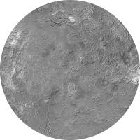
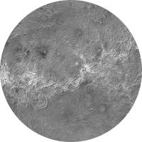
I thought I'd post this here for want of anywhere better. A map of Venus in two hemispheres, 0 and 180 longitude, made of a composite of radar and altimetry datasets from Magellan. Public domain. The map projections are azimuthal equidistant.
Phil
-------------------- ... because the Solar System ain't gonna map itself.
Also to be found posting similar content on https://mastodon.social/@PhilStooke Maps for download (free PD: https://upload.wikimedia.org/wikipedia/comm...Cartography.pdf NOTE: everything created by me which I post on UMSF is considered to be in the public domain (NOT CC, public domain) |
||
|
|
|
||
| Guest_DonPMitchell_* |
Jun 14 2006, 05:08 PM
Post
#3
|
|
Guests |
QUOTE (Phil Stooke @ Jun 14 2006, 09:11 AM)  I thought I'd post this here for want of anywhere better. A map of Venus in two hemispheres, 0 and 180 longitude, made of a composite of radar and altimetry datasets from Magellan. Public domain. The map projections are azimuthal equidistant. Phil Very good. Did you use Venera data at the north pole? Someone needs to map the south pole one of these days. Even the Earth-based radar imaging seems to concentrate on the northern hemisphere for some reason. |
|
|
|
 ljk4-1 Venus Science Feb 10 2006, 10:18 PM
 PhilCo126 Well on the subject of ' early ' missions ... Feb 11 2006, 04:02 PM
 tedstryk QUOTE (PhilCo126 @ Feb 11 2006, 04:02 PM)Well... Feb 11 2006, 04:47 PM Phil Stooke Ted said "My guess is that since Venus was fe... Feb 11 2006, 05:25 PM tedstryk QUOTE (Phil Stooke @ Feb 11 2006, 05:25 PM)Te... Feb 11 2006, 05:46 PM BruceMoomaw In the case of Mariner 1 & 2, there was never ... Feb 12 2006, 06:40 AM edstrick I'd have to dig in "the stacks", but... Feb 12 2006, 08:36 AM BruceMoomaw I remember that -- it was indeed a letter in ... Feb 12 2006, 08:52 AM ljk4-1 Andrew Lepage wrote about Zond 2 in the April, 199... Feb 13 2006, 06:43 AM Gsnorgathon QUOTE (ljk4-1 @ Feb 13 2006, 06:43 A... Feb 13 2006, 05:38 PM Bob Shaw QUOTE (Gsnorgathon @ Feb 13 2006, 05:38 P... Feb 13 2006, 06:50 PM ljk4-1 QUOTE (Bob Shaw @ Feb 13 2006, 01:50 PM) ... Feb 13 2006, 07:38 PM Bob Shaw QUOTE (ljk4-1 @ Feb 13 2006, 07:38 P... Feb 13 2006, 09:00 PM BruceMoomaw QUOTE (ljk4-1 @ Feb 13 2006, 06:43 A... Feb 13 2006, 09:16 AM edstrick Something in my infinitely long list of "woul... Feb 13 2006, 10:15 AM BruceMoomaw I knew some (but not all) of what Ed Strick says a... Feb 13 2006, 10:37 PM edstrick The soviets immediately <speculatively> blam... Feb 14 2006, 09:52 AM ljk4-1 QUOTE (ljk4-1 @ Feb 10 2006, 05:18 P... Feb 14 2006, 04:35 PM ljk4-1 Science/Astronomy:
* Planetary Protection Study G... Feb 22 2006, 04:09 PM JRehling QUOTE (ljk4-1 @ Feb 22 2006, 08:09 A... Feb 22 2006, 04:21 PM ljk4-1 I also get a small thrill out of looking at a plan... Mar 23 2006, 03:32 PM angel1801 Off course, we (depending on location) got a chanc... Mar 25 2006, 06:47 PM ljk4-1 "VENUS' CLIMATE IS TELLING US THAT WE REA... Apr 10 2006, 03:48 PM Julius Unnecessary quote removed - moderator
My biggest ... Apr 13 2006, 09:28 PM ljk4-1 QUOTE (Julius @ Apr 13 2006, 05:28 PM) My... Apr 14 2006, 11:43 PM DonPMitchell A few comments on the Russian probes:
Venera-1 - ... May 5 2006, 02:37 AM DonPMitchell A couple comments on Mariner -2 and -5
I think it... May 5 2006, 02:52 AM BruceMoomaw QUOTE (DonPMitchell @ May 5 2006, 02:52 A... May 5 2006, 06:56 AM DonPMitchell QUOTE (BruceMoomaw @ May 4 2006, 11:56 PM... May 5 2006, 02:30 PM ljk4-1 QUOTE (BruceMoomaw @ May 5 2006, 02:56 AM... May 5 2006, 02:57 PM DonPMitchell QUOTE (ljk4-1 @ May 5 2006, 07:57 AM... May 5 2006, 04:58 PM tedstryk QUOTE (DonPMitchell @ May 5 2006, 04:58 P... May 5 2006, 06:31 PM DonPMitchell QUOTE (tedstryk @ May 5 2006, 11:31 AM) I... May 5 2006, 07:25 PM gndonald QUOTE (DonPMitchell @ May 6 2006, 03:25 A... May 6 2006, 01:34 AM DonPMitchell QUOTE (gndonald @ May 5 2006, 06:34 PM) W... May 6 2006, 03:36 AM gndonald QUOTE (DonPMitchell @ May 6 2006, 11:36 A... May 6 2006, 04:14 AM DonPMitchell QUOTE (gndonald @ May 5 2006, 09:14 PM) N... May 6 2006, 04:34 AM ugordan QUOTE (ljk4-1 @ May 5 2006, 03:57 PM... May 5 2006, 07:02 PM ljk4-1 QUOTE (ugordan @ May 5 2006, 03:02 PM) Co... May 5 2006, 07:17 PM ugordan QUOTE (ljk4-1 @ May 5 2006, 08:17 PM... May 5 2006, 07:27 PM ljk4-1 QUOTE (DonPMitchell @ May 4 2006, 10:52 P... May 5 2006, 03:14 PM BruceMoomaw QUOTE (DonPMitchell @ May 5 2006, 02:37 A... May 5 2006, 06:37 AM edstrick I don't know the exact modelling based on Vene... Apr 14 2006, 09:30 AM BruceMoomaw Venus has both a much greater mass than Mars (abou... Apr 14 2006, 07:01 PM RNeuhaus QUOTE (BruceMoomaw @ Apr 14 2006, 02:01 P... Apr 14 2006, 07:55 PM BruceMoomaw I've often wondered about that, too. The only... May 6 2006, 03:34 AM DonPMitchell QUOTE (BruceMoomaw @ May 5 2006, 08:34 PM... May 6 2006, 03:55 AM BruceMoomaw QUOTE (DonPMitchell @ May 6 2006, 03:55 A... May 6 2006, 05:11 AM DonPMitchell Here's a Venus map I put together for my solar... Jun 14 2006, 05:37 PM Phil Stooke Nice, Don. My map is a composite of two datasets ... Jun 14 2006, 06:07 PM DonPMitchell QUOTE (Phil Stooke @ Jun 14 2006, 11:07 A... Jun 14 2006, 08:10 PM Phil Stooke The relief I used, from Pigwad, does have those st... Jun 14 2006, 08:51 PM JRehling QUOTE (Phil Stooke @ Jun 14 2006, 01:51 P... Jun 15 2006, 02:47 PM Phil Stooke Very nice map, JRehling
Phil Jun 15 2006, 06:12 PM DonPMitchell Yes, that's a nice projection. Jun 15 2006, 06:39 PM ljk4-1 Part V: Astrobiology
Sympathy for the Devil: The ... Jun 19 2006, 07:33 PM Sunspot http://www.newscientistspace.com/article/d...an-th... Nov 2 2006, 10:00 AM cndwrld Excellent Ground-Based Venus Images
At http://www... Mar 27 2007, 09:43 AM JRehling QUOTE (cndwrld @ Mar 27 2007, 02:43 AM) E... Mar 27 2007, 03:41 PM J.J. WOW!!!
Those are far and away the... Mar 27 2007, 06:55 PM tedstryk Check out these images I came across. Looks almos... Apr 9 2007, 07:58 PM JRehling http://www.msnbc.msn.com/id/18040861/
New picture... Apr 10 2007, 08:41 PM elakdawalla Those are the four that were released a couple wee... Apr 10 2007, 08:45 PM AlexBlackwell Speaking of Venus science, the first of several pa... Apr 10 2007, 08:53 PM cndwrld Venus Ground-Based Images
At ESA's pages for ... May 7 2007, 12:39 PM cndwrld Movies of Venus' South Pole Vortex
The ESA sc... May 7 2007, 03:03 PM cndwrld Another set of ground-based images of Venus has no... Jun 20 2007, 03:20 PM
tedstryk QUOTE (PhilCo126 @ Feb 11 2006, 04:02 PM)Well... Feb 11 2006, 04:47 PM Phil Stooke Ted said "My guess is that since Venus was fe... Feb 11 2006, 05:25 PM tedstryk QUOTE (Phil Stooke @ Feb 11 2006, 05:25 PM)Te... Feb 11 2006, 05:46 PM BruceMoomaw In the case of Mariner 1 & 2, there was never ... Feb 12 2006, 06:40 AM edstrick I'd have to dig in "the stacks", but... Feb 12 2006, 08:36 AM BruceMoomaw I remember that -- it was indeed a letter in ... Feb 12 2006, 08:52 AM ljk4-1 Andrew Lepage wrote about Zond 2 in the April, 199... Feb 13 2006, 06:43 AM Gsnorgathon QUOTE (ljk4-1 @ Feb 13 2006, 06:43 A... Feb 13 2006, 05:38 PM Bob Shaw QUOTE (Gsnorgathon @ Feb 13 2006, 05:38 P... Feb 13 2006, 06:50 PM ljk4-1 QUOTE (Bob Shaw @ Feb 13 2006, 01:50 PM) ... Feb 13 2006, 07:38 PM Bob Shaw QUOTE (ljk4-1 @ Feb 13 2006, 07:38 P... Feb 13 2006, 09:00 PM BruceMoomaw QUOTE (ljk4-1 @ Feb 13 2006, 06:43 A... Feb 13 2006, 09:16 AM edstrick Something in my infinitely long list of "woul... Feb 13 2006, 10:15 AM BruceMoomaw I knew some (but not all) of what Ed Strick says a... Feb 13 2006, 10:37 PM edstrick The soviets immediately <speculatively> blam... Feb 14 2006, 09:52 AM ljk4-1 QUOTE (ljk4-1 @ Feb 10 2006, 05:18 P... Feb 14 2006, 04:35 PM ljk4-1 Science/Astronomy:
* Planetary Protection Study G... Feb 22 2006, 04:09 PM JRehling QUOTE (ljk4-1 @ Feb 22 2006, 08:09 A... Feb 22 2006, 04:21 PM ljk4-1 I also get a small thrill out of looking at a plan... Mar 23 2006, 03:32 PM angel1801 Off course, we (depending on location) got a chanc... Mar 25 2006, 06:47 PM ljk4-1 "VENUS' CLIMATE IS TELLING US THAT WE REA... Apr 10 2006, 03:48 PM Julius Unnecessary quote removed - moderator
My biggest ... Apr 13 2006, 09:28 PM ljk4-1 QUOTE (Julius @ Apr 13 2006, 05:28 PM) My... Apr 14 2006, 11:43 PM DonPMitchell A few comments on the Russian probes:
Venera-1 - ... May 5 2006, 02:37 AM DonPMitchell A couple comments on Mariner -2 and -5
I think it... May 5 2006, 02:52 AM BruceMoomaw QUOTE (DonPMitchell @ May 5 2006, 02:52 A... May 5 2006, 06:56 AM DonPMitchell QUOTE (BruceMoomaw @ May 4 2006, 11:56 PM... May 5 2006, 02:30 PM ljk4-1 QUOTE (BruceMoomaw @ May 5 2006, 02:56 AM... May 5 2006, 02:57 PM DonPMitchell QUOTE (ljk4-1 @ May 5 2006, 07:57 AM... May 5 2006, 04:58 PM tedstryk QUOTE (DonPMitchell @ May 5 2006, 04:58 P... May 5 2006, 06:31 PM DonPMitchell QUOTE (tedstryk @ May 5 2006, 11:31 AM) I... May 5 2006, 07:25 PM gndonald QUOTE (DonPMitchell @ May 6 2006, 03:25 A... May 6 2006, 01:34 AM DonPMitchell QUOTE (gndonald @ May 5 2006, 06:34 PM) W... May 6 2006, 03:36 AM gndonald QUOTE (DonPMitchell @ May 6 2006, 11:36 A... May 6 2006, 04:14 AM DonPMitchell QUOTE (gndonald @ May 5 2006, 09:14 PM) N... May 6 2006, 04:34 AM ugordan QUOTE (ljk4-1 @ May 5 2006, 03:57 PM... May 5 2006, 07:02 PM ljk4-1 QUOTE (ugordan @ May 5 2006, 03:02 PM) Co... May 5 2006, 07:17 PM ugordan QUOTE (ljk4-1 @ May 5 2006, 08:17 PM... May 5 2006, 07:27 PM ljk4-1 QUOTE (DonPMitchell @ May 4 2006, 10:52 P... May 5 2006, 03:14 PM BruceMoomaw QUOTE (DonPMitchell @ May 5 2006, 02:37 A... May 5 2006, 06:37 AM edstrick I don't know the exact modelling based on Vene... Apr 14 2006, 09:30 AM BruceMoomaw Venus has both a much greater mass than Mars (abou... Apr 14 2006, 07:01 PM RNeuhaus QUOTE (BruceMoomaw @ Apr 14 2006, 02:01 P... Apr 14 2006, 07:55 PM BruceMoomaw I've often wondered about that, too. The only... May 6 2006, 03:34 AM DonPMitchell QUOTE (BruceMoomaw @ May 5 2006, 08:34 PM... May 6 2006, 03:55 AM BruceMoomaw QUOTE (DonPMitchell @ May 6 2006, 03:55 A... May 6 2006, 05:11 AM DonPMitchell Here's a Venus map I put together for my solar... Jun 14 2006, 05:37 PM Phil Stooke Nice, Don. My map is a composite of two datasets ... Jun 14 2006, 06:07 PM DonPMitchell QUOTE (Phil Stooke @ Jun 14 2006, 11:07 A... Jun 14 2006, 08:10 PM Phil Stooke The relief I used, from Pigwad, does have those st... Jun 14 2006, 08:51 PM JRehling QUOTE (Phil Stooke @ Jun 14 2006, 01:51 P... Jun 15 2006, 02:47 PM Phil Stooke Very nice map, JRehling
Phil Jun 15 2006, 06:12 PM DonPMitchell Yes, that's a nice projection. Jun 15 2006, 06:39 PM ljk4-1 Part V: Astrobiology
Sympathy for the Devil: The ... Jun 19 2006, 07:33 PM Sunspot http://www.newscientistspace.com/article/d...an-th... Nov 2 2006, 10:00 AM cndwrld Excellent Ground-Based Venus Images
At http://www... Mar 27 2007, 09:43 AM JRehling QUOTE (cndwrld @ Mar 27 2007, 02:43 AM) E... Mar 27 2007, 03:41 PM J.J. WOW!!!
Those are far and away the... Mar 27 2007, 06:55 PM tedstryk Check out these images I came across. Looks almos... Apr 9 2007, 07:58 PM JRehling http://www.msnbc.msn.com/id/18040861/
New picture... Apr 10 2007, 08:41 PM elakdawalla Those are the four that were released a couple wee... Apr 10 2007, 08:45 PM AlexBlackwell Speaking of Venus science, the first of several pa... Apr 10 2007, 08:53 PM cndwrld Venus Ground-Based Images
At ESA's pages for ... May 7 2007, 12:39 PM cndwrld Movies of Venus' South Pole Vortex
The ESA sc... May 7 2007, 03:03 PM cndwrld Another set of ground-based images of Venus has no... Jun 20 2007, 03:20 PM |

|
Lo-Fi Version | Time is now: 31st May 2024 - 07:53 PM |
|
RULES AND GUIDELINES Please read the Forum Rules and Guidelines before posting. IMAGE COPYRIGHT |
OPINIONS AND MODERATION Opinions expressed on UnmannedSpaceflight.com are those of the individual posters and do not necessarily reflect the opinions of UnmannedSpaceflight.com or The Planetary Society. The all-volunteer UnmannedSpaceflight.com moderation team is wholly independent of The Planetary Society. The Planetary Society has no influence over decisions made by the UnmannedSpaceflight.com moderators. |
SUPPORT THE FORUM Unmannedspaceflight.com is funded by the Planetary Society. Please consider supporting our work and many other projects by donating to the Society or becoming a member. |
|