Opportunity Route Map |

Opportunity Route Map |
 Feb 11 2005, 08:11 AM Feb 11 2005, 08:11 AM
Post
#1
|
||
 The Insider  Group: Members Posts: 669 Joined: 3-May 04 Member No.: 73 |
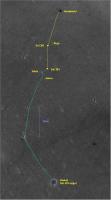
Here is an updated map of the road to Vostok.
Attached thumbnail(s)
|
|
 |
 
|
|
 |
|
Mar 3 2005, 11:18 AM
Post
#2
|
|
|
Founder Group: Chairman Posts: 14433 Joined: 8-February 04 Member No.: 1 |
If it was a mound of any height - we WOULD have seen it by now
 imho - it's a very very erroded crater, much more so than eagle/fram etc - i.e. pre hydrological activity - it'll just be exactly what it appears on the orbital images - a ring of exposed rock perhaps a few CM above the surrounding area with no inner 'dip' or dunes Doug |
|
|
|
 Pando Opportunity Route Map Feb 11 2005, 08:11 AM
 alan Jason, Alvin, and Argo are names of deep sea subme... Feb 11 2005, 02:39 PM djellison QUOTE (alan @ Feb 11 2005, 02:39 PM)Jason, Al... Feb 11 2005, 03:05 PM TheChemist Well, Jason was the guy that got the Golden Fleece... Feb 11 2005, 04:47 PM lyford QUOTE (alan @ Feb 11 2005, 06:39 AM)Jason, Al... Feb 11 2005, 06:57 PM ilbasso Notwithstanding the Chipmunks...
According to htt... Feb 11 2005, 07:09 PM volcanopele QUOTE (TheChemist @ Feb 11 2005, 09:47 AM)Wel... Feb 11 2005, 07:58 PM mhall For what it's worth, I've been inside Alvi... Feb 13 2005, 10:02 PM alan Alvin
http://qt.exploratorium.edu/mars/opportuni..... Feb 20 2005, 06:12 AM imran Another view of Alvin as it was passed (looks very... Feb 20 2005, 06:55 AM imran I updated the "Heatshield to Vostok" map... Feb 20 2005, 07:07 AM Sunspot Endurance Crater is only just visible in the rear ... Feb 20 2005, 10:12 PM OWW Outcrop material without a crater or crack? First ... Feb 20 2005, 10:30 PM Sunspot Is that another crater visible in the distance? Feb 20 2005, 11:02 PM Gray Obsessed - perhaps we're seeing some ancient e... Feb 21 2005, 06:28 PM imran It seems Oppy has moved again although it's ha... Feb 21 2005, 09:18 PM Pando Oppy is currently doing some major driving, possib... Feb 21 2005, 09:57 PM dot.dk Now that is some serious driving! I like it ... Feb 21 2005, 10:20 PM Pando QUOTE (dot.dk @ Feb 21 2005, 03:20 PM)But are... Feb 21 2005, 10:26 PM alan Wow, 450 meters, should have a good view of Vostok... Feb 21 2005, 10:44 PM Sunspot Has anyone found any MOLA data for this area of Me... Feb 21 2005, 11:38 PM Pando I seriously doubt there is any slope there, or it ... Feb 21 2005, 11:56 PM arccos I am still wondering what the dark feature NE from... Feb 22 2005, 01:36 PM Bill Harris QUOTE I am still wondering what the dark feature N... Feb 22 2005, 02:27 PM Sunspot Dunes ......... looking back towards Endurance
ht... Feb 23 2005, 12:10 AM akuo Oppy moves on during sol 385, after sol 384 during... Feb 23 2005, 12:16 AM Sunspot Rear Hazcam for the end of each sol
Sol 383:
htt... Feb 23 2005, 12:25 AM akuo QUOTE (Sunspot @ Feb 23 2005, 12:25 AM)Rear H... Feb 23 2005, 12:31 AM Bubbinski Are the drivers following the zigzag path set out ... Feb 23 2005, 08:14 AM Decepticon QUOTE (Sunspot @ Feb 22 2005, 07:10 PM)Dunes ... Feb 23 2005, 01:09 PM ToSeek Any idea where Opportunity is now? The navcam pan ... Feb 23 2005, 07:53 PM Sunspot It's impossible to say, we'll have to wait... Feb 23 2005, 08:28 PM Bubbinski So far no new images from sol 386 are in at the ex... Feb 24 2005, 08:06 AM Pando Based on some of the latest images, looks like Opp... Feb 24 2005, 08:36 AM Sunspot QUOTE (Bubbinski @ Feb 24 2005, 08:06 AM)So f... Feb 24 2005, 09:11 AM OWW According to the latest director update ( February... Feb 24 2005, 05:49 PM dot.dk I had to listen more than one time to confirm that... Feb 24 2005, 06:04 PM Marslauncher so any idea where we are yet? Feb 24 2005, 07:41 PM Marslauncher http://qt.exploratorium.edu:16080/mars/opp...00P26... Feb 24 2005, 07:47 PM ToSeek QUOTE (ObsessedWithWorlds @ Feb 24 2005, 05:4... Feb 24 2005, 08:06 PM Sunspot I think she meant they were waiting for an imminen... Feb 24 2005, 08:12 PM Pando QUOTE so any idea where we are yet?
I think we... Feb 24 2005, 09:08 PM dot.dk This must be the cluster of small craters on to th... Feb 25 2005, 12:42 AM Sunspot WHOAHHHH !!!!
They must have done... Feb 25 2005, 12:49 AM dot.dk This is a mystery to me...
Very quick and dirty p... Feb 25 2005, 01:05 AM dot.dk Perhaps they turned right where we can see the rov... Feb 25 2005, 01:08 AM Sunspot I'm assuming these pancam images were taken lo... Feb 25 2005, 01:14 AM Pando Sol 383: 177m
Sol 384: 104m
Sol 385: 109m
Sol 386:... Feb 25 2005, 01:32 AM MahFL I think they did turn right as if you notice the t... Feb 25 2005, 02:32 AM alan QUOTE (alan @ Feb 21 2005, 10:44 PM)Wow, 450 ... Feb 25 2005, 03:10 AM TheChemist Luckily, we have a beacon pointing to North Feb 25 2005, 10:18 AM babakm Judging by the tracks, the feature on the horizon ... Feb 25 2005, 05:10 PM Pando That can't be because it's look at West. V... Feb 25 2005, 05:34 PM babakm QUOTE (Pando @ Feb 25 2005, 05:34 PM)That can... Feb 25 2005, 08:09 PM Pando Personally I don't think Vostok is visible at ... Feb 25 2005, 08:36 PM Fred I thought this was Vostok. It's about a third... Feb 26 2005, 03:26 AM djellison QUOTE (Fred @ Feb 26 2005, 03:26 AM)I thought... Feb 26 2005, 10:48 AM TheChemist And an updated JPL Opportunity Route Map :
Large ... Feb 26 2005, 06:14 PM dot.dk They will have a hard time keeping this map up to ... Feb 26 2005, 07:07 PM Decepticon ^ WOW! How close are they to Vostok? Feb 26 2005, 09:00 PM dot.dk QUOTE (Decepticon @ Feb 26 2005, 09:00 PM)^ W... Feb 26 2005, 09:10 PM Sunspot ....damn, I guess the person that updates the pict... Feb 27 2005, 01:04 PM Sunspot Sol 389 Pancam images......
http://marsrovers.jpl... Feb 27 2005, 08:08 PM argv Blueberries everywhere we look. I got a creepy fe... Feb 28 2005, 03:51 AM TheChemist Sol 390 raw images have arrived!
http://marsr... Feb 28 2005, 04:20 PM Sunspot Could this be in the direction of Vostok?
http://... Feb 28 2005, 06:52 PM erwan Sunspot: to my opinion, Pancam images from Sol 390... Feb 28 2005, 09:09 PM Pando Updated Opportunity route map. Mar 2 2005, 10:22 PM gregp1962 So, are we at Vostok? The map above makes it appea... Mar 3 2005, 12:59 AM Pando QUOTE (gregp1962 @ Mar 2 2005, 05:59 PM)So, a... Mar 3 2005, 01:06 AM Sunspot I wonder if it would be possible to add a mars clo... Mar 3 2005, 01:23 AM Pando Good idea..... Doug?
or that one in the offic... Mar 3 2005, 01:28 AM Pando Going off-topic here but here's probably the c... Mar 3 2005, 01:40 AM lyford QUOTE (Sunspot @ Mar 2 2005, 05:23 PM)I wonde... Mar 3 2005, 03:00 AM MiniTES QUOTE (lyford @ Mar 3 2005, 03:00 AM)QUOTE (S... Mar 3 2005, 03:35 AM Gsnorgathon Don't forget Mars24... Mar 3 2005, 05:33 AM djellison QUOTE (Sunspot @ Mar 3 2005, 01:23 AM)I wonde... Mar 3 2005, 08:54 AM TheChemist I noticed in the last route update, that Opportuni... Mar 3 2005, 09:34 AM cIclops QUOTE (TheChemist @ Mar 3 2005, 09:34 AM)I no... Mar 3 2005, 10:39 AM TheChemist QUOTE (cIclops @ Mar 3 2005, 12:39 PM)QUOTE (... Mar 3 2005, 11:22 AM erwan According to Pando's last Opportunity routemap... Mar 3 2005, 01:10 PM SFJCody Astrobio has a nice javascript Mars clock. Just ad... Mar 3 2005, 01:45 PM djellison To be honest - it'd piss me off If I want to ... Mar 3 2005, 02:05 PM mhoward QUOTE (MiniTES @ Mar 3 2005, 03:35 AM)That... Mar 3 2005, 04:01 PM lyford QUOTE (cIclops @ Mar 3 2005, 02:39 AM)new pan... Mar 3 2005, 05:04 PM erwan Looking all around Naturalist QTVR Pan; damnation,... Mar 3 2005, 06:15 PM Deimos QUOTE (Sunspot @ Mar 3 2005, 01:23 AM)I wonde... Mar 3 2005, 06:33 PM Pando curious, why choose Deimos as opposed to Phobos as... Mar 3 2005, 06:55 PM Sunspot QUOTE (cIclops @ Mar 3 2005, 10:39 AM)QUOTE (... Mar 4 2005, 02:02 PM cIclops QUOTE (Sunspot @ Mar 4 2005, 02:02 PM)I think... Mar 4 2005, 03:11 PM ToSeek Vostok was the Russian equivalent of the American ... Mar 4 2005, 03:38 PM erwan cIclops: your post raises the question of Vostok... Mar 4 2005, 03:49 PM Sunspot Daily updates are coming in for Spirit..nothing fo... Mar 4 2005, 07:22 PM Pando Yes, driving on Sols 394,396,397, no drive for tod... Mar 4 2005, 08:51 PM Pando Looks like a nice long drive backwards toward Sout... Mar 5 2005, 01:23 AM erwan Hello Pando, mhoward, folks: i wonder why Pando ju... Mar 5 2005, 02:02 AM OWW Yes, exploratorium is back, but it skipped the Pan... Mar 5 2005, 08:22 AM mhoward QUOTE (ObsessedWithWorlds @ Mar 5 2005, 08:22... Mar 5 2005, 02:31 PM
alan Jason, Alvin, and Argo are names of deep sea subme... Feb 11 2005, 02:39 PM djellison QUOTE (alan @ Feb 11 2005, 02:39 PM)Jason, Al... Feb 11 2005, 03:05 PM TheChemist Well, Jason was the guy that got the Golden Fleece... Feb 11 2005, 04:47 PM lyford QUOTE (alan @ Feb 11 2005, 06:39 AM)Jason, Al... Feb 11 2005, 06:57 PM ilbasso Notwithstanding the Chipmunks...
According to htt... Feb 11 2005, 07:09 PM volcanopele QUOTE (TheChemist @ Feb 11 2005, 09:47 AM)Wel... Feb 11 2005, 07:58 PM mhall For what it's worth, I've been inside Alvi... Feb 13 2005, 10:02 PM alan Alvin
http://qt.exploratorium.edu/mars/opportuni..... Feb 20 2005, 06:12 AM imran Another view of Alvin as it was passed (looks very... Feb 20 2005, 06:55 AM imran I updated the "Heatshield to Vostok" map... Feb 20 2005, 07:07 AM Sunspot Endurance Crater is only just visible in the rear ... Feb 20 2005, 10:12 PM OWW Outcrop material without a crater or crack? First ... Feb 20 2005, 10:30 PM Sunspot Is that another crater visible in the distance? Feb 20 2005, 11:02 PM Gray Obsessed - perhaps we're seeing some ancient e... Feb 21 2005, 06:28 PM imran It seems Oppy has moved again although it's ha... Feb 21 2005, 09:18 PM Pando Oppy is currently doing some major driving, possib... Feb 21 2005, 09:57 PM dot.dk Now that is some serious driving! I like it ... Feb 21 2005, 10:20 PM Pando QUOTE (dot.dk @ Feb 21 2005, 03:20 PM)But are... Feb 21 2005, 10:26 PM alan Wow, 450 meters, should have a good view of Vostok... Feb 21 2005, 10:44 PM Sunspot Has anyone found any MOLA data for this area of Me... Feb 21 2005, 11:38 PM Pando I seriously doubt there is any slope there, or it ... Feb 21 2005, 11:56 PM arccos I am still wondering what the dark feature NE from... Feb 22 2005, 01:36 PM Bill Harris QUOTE I am still wondering what the dark feature N... Feb 22 2005, 02:27 PM Sunspot Dunes ......... looking back towards Endurance
ht... Feb 23 2005, 12:10 AM akuo Oppy moves on during sol 385, after sol 384 during... Feb 23 2005, 12:16 AM Sunspot Rear Hazcam for the end of each sol
Sol 383:
htt... Feb 23 2005, 12:25 AM akuo QUOTE (Sunspot @ Feb 23 2005, 12:25 AM)Rear H... Feb 23 2005, 12:31 AM Bubbinski Are the drivers following the zigzag path set out ... Feb 23 2005, 08:14 AM Decepticon QUOTE (Sunspot @ Feb 22 2005, 07:10 PM)Dunes ... Feb 23 2005, 01:09 PM ToSeek Any idea where Opportunity is now? The navcam pan ... Feb 23 2005, 07:53 PM Sunspot It's impossible to say, we'll have to wait... Feb 23 2005, 08:28 PM Bubbinski So far no new images from sol 386 are in at the ex... Feb 24 2005, 08:06 AM Pando Based on some of the latest images, looks like Opp... Feb 24 2005, 08:36 AM Sunspot QUOTE (Bubbinski @ Feb 24 2005, 08:06 AM)So f... Feb 24 2005, 09:11 AM OWW According to the latest director update ( February... Feb 24 2005, 05:49 PM dot.dk I had to listen more than one time to confirm that... Feb 24 2005, 06:04 PM Marslauncher so any idea where we are yet? Feb 24 2005, 07:41 PM Marslauncher http://qt.exploratorium.edu:16080/mars/opp...00P26... Feb 24 2005, 07:47 PM ToSeek QUOTE (ObsessedWithWorlds @ Feb 24 2005, 05:4... Feb 24 2005, 08:06 PM Sunspot I think she meant they were waiting for an imminen... Feb 24 2005, 08:12 PM Pando QUOTE so any idea where we are yet?
I think we... Feb 24 2005, 09:08 PM dot.dk This must be the cluster of small craters on to th... Feb 25 2005, 12:42 AM Sunspot WHOAHHHH !!!!
They must have done... Feb 25 2005, 12:49 AM dot.dk This is a mystery to me...
Very quick and dirty p... Feb 25 2005, 01:05 AM dot.dk Perhaps they turned right where we can see the rov... Feb 25 2005, 01:08 AM Sunspot I'm assuming these pancam images were taken lo... Feb 25 2005, 01:14 AM Pando Sol 383: 177m
Sol 384: 104m
Sol 385: 109m
Sol 386:... Feb 25 2005, 01:32 AM MahFL I think they did turn right as if you notice the t... Feb 25 2005, 02:32 AM alan QUOTE (alan @ Feb 21 2005, 10:44 PM)Wow, 450 ... Feb 25 2005, 03:10 AM TheChemist Luckily, we have a beacon pointing to North Feb 25 2005, 10:18 AM babakm Judging by the tracks, the feature on the horizon ... Feb 25 2005, 05:10 PM Pando That can't be because it's look at West. V... Feb 25 2005, 05:34 PM babakm QUOTE (Pando @ Feb 25 2005, 05:34 PM)That can... Feb 25 2005, 08:09 PM Pando Personally I don't think Vostok is visible at ... Feb 25 2005, 08:36 PM Fred I thought this was Vostok. It's about a third... Feb 26 2005, 03:26 AM djellison QUOTE (Fred @ Feb 26 2005, 03:26 AM)I thought... Feb 26 2005, 10:48 AM TheChemist And an updated JPL Opportunity Route Map :
Large ... Feb 26 2005, 06:14 PM dot.dk They will have a hard time keeping this map up to ... Feb 26 2005, 07:07 PM Decepticon ^ WOW! How close are they to Vostok? Feb 26 2005, 09:00 PM dot.dk QUOTE (Decepticon @ Feb 26 2005, 09:00 PM)^ W... Feb 26 2005, 09:10 PM Sunspot ....damn, I guess the person that updates the pict... Feb 27 2005, 01:04 PM Sunspot Sol 389 Pancam images......
http://marsrovers.jpl... Feb 27 2005, 08:08 PM argv Blueberries everywhere we look. I got a creepy fe... Feb 28 2005, 03:51 AM TheChemist Sol 390 raw images have arrived!
http://marsr... Feb 28 2005, 04:20 PM Sunspot Could this be in the direction of Vostok?
http://... Feb 28 2005, 06:52 PM erwan Sunspot: to my opinion, Pancam images from Sol 390... Feb 28 2005, 09:09 PM Pando Updated Opportunity route map. Mar 2 2005, 10:22 PM gregp1962 So, are we at Vostok? The map above makes it appea... Mar 3 2005, 12:59 AM Pando QUOTE (gregp1962 @ Mar 2 2005, 05:59 PM)So, a... Mar 3 2005, 01:06 AM Sunspot I wonder if it would be possible to add a mars clo... Mar 3 2005, 01:23 AM Pando Good idea..... Doug?
or that one in the offic... Mar 3 2005, 01:28 AM Pando Going off-topic here but here's probably the c... Mar 3 2005, 01:40 AM lyford QUOTE (Sunspot @ Mar 2 2005, 05:23 PM)I wonde... Mar 3 2005, 03:00 AM MiniTES QUOTE (lyford @ Mar 3 2005, 03:00 AM)QUOTE (S... Mar 3 2005, 03:35 AM Gsnorgathon Don't forget Mars24... Mar 3 2005, 05:33 AM djellison QUOTE (Sunspot @ Mar 3 2005, 01:23 AM)I wonde... Mar 3 2005, 08:54 AM TheChemist I noticed in the last route update, that Opportuni... Mar 3 2005, 09:34 AM cIclops QUOTE (TheChemist @ Mar 3 2005, 09:34 AM)I no... Mar 3 2005, 10:39 AM TheChemist QUOTE (cIclops @ Mar 3 2005, 12:39 PM)QUOTE (... Mar 3 2005, 11:22 AM erwan According to Pando's last Opportunity routemap... Mar 3 2005, 01:10 PM SFJCody Astrobio has a nice javascript Mars clock. Just ad... Mar 3 2005, 01:45 PM djellison To be honest - it'd piss me off If I want to ... Mar 3 2005, 02:05 PM mhoward QUOTE (MiniTES @ Mar 3 2005, 03:35 AM)That... Mar 3 2005, 04:01 PM lyford QUOTE (cIclops @ Mar 3 2005, 02:39 AM)new pan... Mar 3 2005, 05:04 PM erwan Looking all around Naturalist QTVR Pan; damnation,... Mar 3 2005, 06:15 PM Deimos QUOTE (Sunspot @ Mar 3 2005, 01:23 AM)I wonde... Mar 3 2005, 06:33 PM Pando curious, why choose Deimos as opposed to Phobos as... Mar 3 2005, 06:55 PM Sunspot QUOTE (cIclops @ Mar 3 2005, 10:39 AM)QUOTE (... Mar 4 2005, 02:02 PM cIclops QUOTE (Sunspot @ Mar 4 2005, 02:02 PM)I think... Mar 4 2005, 03:11 PM ToSeek Vostok was the Russian equivalent of the American ... Mar 4 2005, 03:38 PM erwan cIclops: your post raises the question of Vostok... Mar 4 2005, 03:49 PM Sunspot Daily updates are coming in for Spirit..nothing fo... Mar 4 2005, 07:22 PM Pando Yes, driving on Sols 394,396,397, no drive for tod... Mar 4 2005, 08:51 PM Pando Looks like a nice long drive backwards toward Sout... Mar 5 2005, 01:23 AM erwan Hello Pando, mhoward, folks: i wonder why Pando ju... Mar 5 2005, 02:02 AM OWW Yes, exploratorium is back, but it skipped the Pan... Mar 5 2005, 08:22 AM mhoward QUOTE (ObsessedWithWorlds @ Mar 5 2005, 08:22... Mar 5 2005, 02:31 PM Sunspot According to Pando's routhe map todays drive s... Mar 5 2005, 03:18 PM
 |

|
Lo-Fi Version | Time is now: 14th June 2024 - 01:51 AM |
|
RULES AND GUIDELINES Please read the Forum Rules and Guidelines before posting. IMAGE COPYRIGHT |
OPINIONS AND MODERATION Opinions expressed on UnmannedSpaceflight.com are those of the individual posters and do not necessarily reflect the opinions of UnmannedSpaceflight.com or The Planetary Society. The all-volunteer UnmannedSpaceflight.com moderation team is wholly independent of The Planetary Society. The Planetary Society has no influence over decisions made by the UnmannedSpaceflight.com moderators. |
SUPPORT THE FORUM Unmannedspaceflight.com is funded by the Planetary Society. Please consider supporting our work and many other projects by donating to the Society or becoming a member. |
|