Hell of a View, Where exactly was it? |

Hell of a View, Where exactly was it? |
 Jul 10 2006, 06:27 AM Jul 10 2006, 06:27 AM
Post
#1
|
||
 Senior Member  Group: Members Posts: 2228 Joined: 1-December 04 From: Marble Falls, Texas, USA Member No.: 116 |
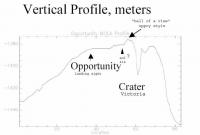
For a long time I have been curious about the fabled, "Hell of a view" location. Although I was expecting it along with the rest of you, I wasn't actively looking for it at the critical time. So, I decided to look back to define its location. It appears to me that "Hell of a View" (HoaV) was topped by Opportunity on sol 785. It is difficult to pick exactly when she began to descend from HoaV, but it was between sols 787 and 814. If anyone wants to count pixels to more precisely define it, be my guest.
I am attaching a montage of horizons, screen-captured with MMB at a constant magnification. It is captioned to note how the appearance of Beagle crater changes with respect to the horizon, as Opportunity changes in elevation. I have another montage combining Phil's most excellent route map with a stretched version of the original HoaV profile. Stretching the profile between Eagle and Beagle confirms a location for HoaV in about the same place. I just do not have time to upload it on dialup tonight. I'll post it tomorrow. Sorry. I thought it might be fun to see who, if anyone, recognized the event when it occurred. Kind of like a reverse poll, where it is too late to hedge your bet.  Searching the forum for relevant posts is difficult, but I came up with a couple of links. I suspect there may be one or two comments that I missed, so post your links here. Searching the forum for relevant posts is difficult, but I came up with a couple of links. I suspect there may be one or two comments that I missed, so post your links here.As we left Erebus behind, RedSky asked where HoaV would be. Phil and centsworth_II made pretty good predictions for the time. http://www.unmannedspaceflight.com/index.p...amp;#entry45719 On this low-fi view of the forum, I discovered that Chmee seems to have recognized the topographic topover on April 14th, 2006. A little later Dilo agreed, and noted that Opportunity was descending. That was around sol 789. http://www.unmannedspaceflight.com/index.p...;f=2&t=2417 Their recognitions are the best I could find, and so far, the winners.
Attached thumbnail(s)
-------------------- ...Tom
I'm not a Space Fan, I'm a Space Exploration Enthusiast. |
|
 |
 
|
|
 |
|
Jul 11 2006, 04:20 AM
Post
#2
|
|||
|
Senior Member Group: Members Posts: 2228 Joined: 1-December 04 From: Marble Falls, Texas, USA Member No.: 116 |
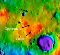
QUOTE (BrianL @ Jul 10 2006, 06:10 AM)  My gut feeling is that HoaV never happened. HoaV to me means coming over a rise and having the view take your breath away. ... Well, it did actually happen, but your point is well taken and worth mentioning. It really wasn't the view that some were expecting. The MOLA data that created the map that the profile was derived from had relatively widely spaced control points. So much detail is missing, that the map and profile are misleading to people who are expecting to see things like Victoria's rim in the data. That level of detail is just not there.QUOTE (chris @ Jul 10 2006, 06:16 AM) Ho-hum of a view perhaps... Yeah, I can't argue with that. That's probably why it mostly escaped notice in the forum at the time.QUOTE (Bill Harris @ Jul 10 2006, 06:19 AM) The Heck of a View was rather underwhelming, wasn't it? At the topographic high on Sol 785, the view back to Erebus was non-existent and the view forward to Victoria was nearly that. ... Underwhelming is probably the best one-word description. Though the view from those "lofty" elevations wasn't impressive, the identification of the actual high point was a significant event. I'm still not certain that I agree with your contention that the bedding is so close to horizontal that the elevation high corresponds to a stratigraphic one. I've seen local dips all over the map along this long traverse, but it seems to me that the average is a slight dip to the south.Regardless of who is right about that, it would have been important for the MER team to recognize the elevation high and take a number of bedrock observations there, as we've mentioned. I checked back into the archived Opportunity updates (http://marsrovers.jpl.nasa.gov/mission/status_opportunityAll.html), and it does appear that they stopped to smell the roses more often than usual after sol 791. _________________________ I think these are the original posts where the story of "Hell of a View" may have begun, but it might go back to an earlier post from alan. If anyone can find that, please post a link. Look here. There was a large (18 MB) pdf file linked to in the posts there. Later, a topographic map and a profile were extracted from the pdf and posted. I will add those images as attachments to at least show the captioned profile and the map it appears to have been derived from.
Attached thumbnail(s)
-------------------- ...Tom
I'm not a Space Fan, I'm a Space Exploration Enthusiast. |
||
|
|
|
||
 CosmicRocker Hell of a View Jul 10 2006, 06:27 AM
 BrianL QUOTE (CosmicRocker @ Jul 10 2006, 01:27 ... Jul 10 2006, 11:10 AM
 chris Ho-hum of a view perhaps...
Chris Jul 10 2006, 11:16 AM Bill Harris The Heck of a View was rather underwhelming, wasn... Jul 10 2006, 11:19 AM Bob Shaw To be honest, I never reckoned the MOLA altitude f... Jul 10 2006, 12:01 PM ElkGroveDan Let's look at it this way. For those of us ex... Jul 10 2006, 02:23 PM stevelu Ah, I tuned in to this discussion thinking that we... Jul 10 2006, 07:47 PM stevelu Oops.
Let's try that again: Jul 10 2006, 07:49 PM atomoid I was unbelieving... are we actually looking down ... Jul 10 2006, 09:17 PM David S. I may be completely off but aren't those twin ... Jul 10 2006, 10:04 PM SFJCody QUOTE (David S. @ Jul 10 2006, 11:04 PM) ... Jul 10 2006, 11:34 PM lars_J QUOTE (atomoid @ Jul 10 2006, 04:17 PM) I... Jul 10 2006, 10:05 PM atomoid Ok, i was completely nuts, dont listen to me. If ... Jul 11 2006, 12:13 AM CosmicRocker QUOTE (David S. @ Jul 10 2006, 05:04 PM) ... Jul 11 2006, 12:20 AM fredk QUOTE (CosmicRocker @ Jul 11 2006, 04:20 ... Jul 11 2006, 04:10 PM Bill Harris QUOTE I'm still not certain that I agree with ... Jul 11 2006, 04:54 AM CosmicRocker Ok. This will be my last post tonight, but yester... Jul 11 2006, 05:30 AM CosmicRocker Well, maybe that was my second-to-last post. ... Jul 11 2006, 05:40 AM Bill Harris I basically agree with you on the issue of the dip... Jul 11 2006, 10:35 AM fredk As far as defining a HoaV point, I think the point... Jul 11 2006, 05:58 PM Pertinax Based on USGS' MOLA / MOC NA Stereo DEM of the... Jul 12 2006, 08:35 PM CosmicRocker QUOTE (fredk @ Jul 11 2006, 11:10 AM) I r... Jul 13 2006, 05:21 AM Bill Harris Probably the closest thing we had to "A Heck ... Jul 13 2006, 09:17 AM BrianL QUOTE (Bill Harris @ Jul 13 2006, 04:17 A... Jul 13 2006, 09:59 PM fredk That was a nice view, Bill. I can't resist me... Jul 13 2006, 05:36 PM Pertinax I should be able to do both. We have stormy weath... Jul 13 2006, 05:45 PM Bill Harris QUOTE ...pancam mosaic by Dilo from the Olympia/Pu... Jul 13 2006, 10:26 PM CosmicRocker Pertinax: I can see that you may be busy with oth... Jul 17 2006, 05:15 AM Pertinax No, I have not been able to find the actual / true... Jul 17 2006, 12:46 PM
chris Ho-hum of a view perhaps...
Chris Jul 10 2006, 11:16 AM Bill Harris The Heck of a View was rather underwhelming, wasn... Jul 10 2006, 11:19 AM Bob Shaw To be honest, I never reckoned the MOLA altitude f... Jul 10 2006, 12:01 PM ElkGroveDan Let's look at it this way. For those of us ex... Jul 10 2006, 02:23 PM stevelu Ah, I tuned in to this discussion thinking that we... Jul 10 2006, 07:47 PM stevelu Oops.
Let's try that again: Jul 10 2006, 07:49 PM atomoid I was unbelieving... are we actually looking down ... Jul 10 2006, 09:17 PM David S. I may be completely off but aren't those twin ... Jul 10 2006, 10:04 PM SFJCody QUOTE (David S. @ Jul 10 2006, 11:04 PM) ... Jul 10 2006, 11:34 PM lars_J QUOTE (atomoid @ Jul 10 2006, 04:17 PM) I... Jul 10 2006, 10:05 PM atomoid Ok, i was completely nuts, dont listen to me. If ... Jul 11 2006, 12:13 AM CosmicRocker QUOTE (David S. @ Jul 10 2006, 05:04 PM) ... Jul 11 2006, 12:20 AM fredk QUOTE (CosmicRocker @ Jul 11 2006, 04:20 ... Jul 11 2006, 04:10 PM Bill Harris QUOTE I'm still not certain that I agree with ... Jul 11 2006, 04:54 AM CosmicRocker Ok. This will be my last post tonight, but yester... Jul 11 2006, 05:30 AM CosmicRocker Well, maybe that was my second-to-last post. ... Jul 11 2006, 05:40 AM Bill Harris I basically agree with you on the issue of the dip... Jul 11 2006, 10:35 AM fredk As far as defining a HoaV point, I think the point... Jul 11 2006, 05:58 PM Pertinax Based on USGS' MOLA / MOC NA Stereo DEM of the... Jul 12 2006, 08:35 PM CosmicRocker QUOTE (fredk @ Jul 11 2006, 11:10 AM) I r... Jul 13 2006, 05:21 AM Bill Harris Probably the closest thing we had to "A Heck ... Jul 13 2006, 09:17 AM BrianL QUOTE (Bill Harris @ Jul 13 2006, 04:17 A... Jul 13 2006, 09:59 PM fredk That was a nice view, Bill. I can't resist me... Jul 13 2006, 05:36 PM Pertinax I should be able to do both. We have stormy weath... Jul 13 2006, 05:45 PM Bill Harris QUOTE ...pancam mosaic by Dilo from the Olympia/Pu... Jul 13 2006, 10:26 PM CosmicRocker Pertinax: I can see that you may be busy with oth... Jul 17 2006, 05:15 AM Pertinax No, I have not been able to find the actual / true... Jul 17 2006, 12:46 PM |

|
Lo-Fi Version | Time is now: 24th June 2024 - 08:39 PM |
|
RULES AND GUIDELINES Please read the Forum Rules and Guidelines before posting. IMAGE COPYRIGHT |
OPINIONS AND MODERATION Opinions expressed on UnmannedSpaceflight.com are those of the individual posters and do not necessarily reflect the opinions of UnmannedSpaceflight.com or The Planetary Society. The all-volunteer UnmannedSpaceflight.com moderation team is wholly independent of The Planetary Society. The Planetary Society has no influence over decisions made by the UnmannedSpaceflight.com moderators. |
SUPPORT THE FORUM Unmannedspaceflight.com is funded by the Planetary Society. Please consider supporting our work and many other projects by donating to the Society or becoming a member. |
|