Opportunity Route Map |

Opportunity Route Map |
 Feb 11 2005, 08:11 AM Feb 11 2005, 08:11 AM
Post
#1
|
||
 The Insider  Group: Members Posts: 669 Joined: 3-May 04 Member No.: 73 |
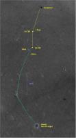
Here is an updated map of the road to Vostok.
Attached thumbnail(s)
|
|
 |
 
|
|
 |
|
Aug 15 2006, 01:40 PM
Post
#2
|
|
 Member Group: Members Posts: 133 Joined: 3-June 06 From: the jungle of Nool Member No.: 799 |
estimated sol 909 position:
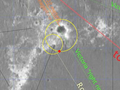 This is based on the sol 908 Navcam image measurment of 32 +/- 2 meters to the south rim of Beagle less the apparent 5 meter movement north on sol 909 -- and a sol 909 Navcam measurment of 16.6 +/- 0.5 meters to a rock on the edge of Beagle Highway outcrop to the west. The north movement was a surprise. I measured a sol 908 navcam southward rock distance of 13.7 +/- 0.4 and a sol 909 pancam distance of 18.8 +/- 0.2. I am mystified by this movement. |
|
|
|
 Pando Opportunity Route Map Feb 11 2005, 08:11 AM
 jamescanvin I still don't understand the reason for using ... Jul 21 2006, 12:11 AM
 algorimancer QUOTE (jamescanvin @ Jul 20 2006, 07:11 P... Jul 21 2006, 12:52 AM
 mhoward QUOTE (jamescanvin @ Jul 21 2006, 12:11 A... Jul 21 2006, 12:55 AM jamescanvin Route map updated to sol 885 - Small (2.6m accordi... Jul 21 2006, 09:43 PM hortonheardawho QUOTE (jamescanvin @ Jul 21 2006, 05:43 P... Jul 21 2006, 10:45 PM hortonheardawho Ooops:
Got Before and after mixed up in the super... Jul 21 2006, 11:20 PM Toma B After 6 days we are continuing drive toward Beagle... Jul 27 2006, 12:04 PM antoniseb I'm sure it has been explained somewhere, but ... Jul 27 2006, 12:15 PM Phil Stooke It's the penultimate and ultimate hazcam image... Jul 27 2006, 12:33 PM Toma B QUOTE (antoniseb @ Jul 27 2006, 02:15 PM)... Jul 27 2006, 01:29 PM djellison I'll start a thread for PC Database related st... Jul 27 2006, 01:41 PM climber Sometime, it's nice to sit and look some stats... Jul 27 2006, 05:03 PM jamescanvin Without many of the navcams ploting the 891 positi... Jul 28 2006, 03:04 AM mhoward QUOTE (jamescanvin @ Jul 28 2006, 03:04 A... Jul 29 2006, 09:16 PM Phil Stooke I had it at almost the same place, maybe one red d... Jul 28 2006, 03:17 AM abalone Finally here Jul 28 2006, 11:22 AM dvandorn Well -- not quite there yet. I thought we decided... Jul 29 2006, 05:08 AM Tesheiner Glad to see the rover almost at Beagle Crater.
No,... Jul 29 2006, 09:43 PM RNeuhaus Now opportunity is sitting about 25 meters (82 fee... Jul 31 2006, 07:41 PM dot.dk QUOTE (RNeuhaus @ Jul 31 2006, 09:41 PM) ... Aug 1 2006, 12:31 AM RNeuhaus QUOTE (dot.dk @ Jul 31 2006, 07:31 PM) No... Aug 1 2006, 10:57 PM CosmicRocker RE: Opportunity Route Map Aug 1 2006, 05:00 AM climber 200.000 hits on this topic...but only a month to g... Aug 1 2006, 05:50 PM Holder of the Two Leashes QUOTE (climber @ Aug 1 2006, 12:50 PM) 20... Aug 1 2006, 07:49 PM akuo Over how? Manouvering around Victoria is going to ... Aug 1 2006, 08:04 PM dshaffer QUOTE (akuo @ Aug 1 2006, 03:04 PM) Over ... Aug 1 2006, 09:56 PM climber Oups! I thought I was in "going South to ... Aug 1 2006, 08:59 PM Bill Harris QUOTE The navigation direction would be close to S... Aug 1 2006, 11:27 PM diane QUOTE (Bill Harris @ Aug 1 2006, 07:27 PM... Aug 1 2006, 11:40 PM jamescanvin Note that 108 degrees doen't really mean anyth... Aug 1 2006, 11:56 PM RNeuhaus QUOTE (jamescanvin @ Aug 1 2006, 06:56 PM... Aug 2 2006, 02:25 PM jamescanvin Some tracking data is up for 896!
We've ... Aug 2 2006, 12:24 AM jamescanvin Route map for Sol 896. Aug 2 2006, 02:42 AM jamescanvin Sol 898 route map.
A short drive to position Op... Aug 4 2006, 02:49 AM CosmicRocker I hope you have an enjoyable respite, and thanks f... Aug 4 2006, 04:39 AM Sunspot I wonder if they'll drive further to the right... Aug 4 2006, 11:31 AM Phil Stooke My guess is that Opportunity will head east toward... Aug 4 2006, 05:07 PM fredk My own guess of the best approach to VC would be d... Aug 4 2006, 07:22 PM Bill Harris I'd go for the naming of names on the Route Ma... Aug 4 2006, 08:27 PM Phil Stooke My map - which has been posted here before in a re... Aug 4 2006, 08:34 PM Pavel QUOTE (Phil Stooke @ Aug 4 2006, 04:34 PM... Aug 6 2006, 03:29 PM Phil Stooke OK, it's over in the Spirit area.
Phil Aug 6 2006, 04:40 PM algorimancer Just FYI, especially for the benefit of the mapper... Aug 8 2006, 01:21 PM gregp1962 Wasn't today a drve sol? Aug 8 2006, 11:16 PM RNeuhaus QUOTE (gregp1962 @ Aug 8 2006, 06:16 PM) ... Aug 9 2006, 01:13 AM djellison QUOTE (RNeuhaus @ Aug 9 2006, 02:13 AM) T... Aug 9 2006, 07:07 AM dot.dk http://www.newscientistspace.com/article/d...good-... Aug 9 2006, 12:40 PM djellison 5 days - sounds like one thorough IDD campaign to ... Aug 9 2006, 12:51 PM Pando Here's a nice map (a bit old though). Not sure... Aug 12 2006, 12:45 AM ElkGroveDan QUOTE (Pando @ Aug 11 2006, 04:45 PM) Her... Aug 12 2006, 04:24 AM CosmicRocker No, we haven't! ...and it's a keeper.... Aug 12 2006, 04:05 AM aldo12xu QUOTE (CosmicRocker @ Aug 12 2006, 04:05 ... Aug 12 2006, 05:15 AM CosmicRocker Good to see you on the hunt, aldo12xu. This n... Aug 12 2006, 06:59 AM djellison That image is from the S11 phase of MGS ops, so it... Aug 12 2006, 07:57 AM Bill Harris Thanks, Pando. I thought this was one of Phil... Aug 12 2006, 10:17 AM CosmicRocker 907 looks like roughly a twenty meter drive almost... Aug 14 2006, 01:44 AM Phil Stooke ...and here's my version.
Phil
(PS I... Aug 14 2006, 02:36 AM CosmicRocker Damn! You don't know how relieved I am to... Aug 14 2006, 04:35 AM RNeuhaus QUOTE (CosmicRocker @ Aug 13 2006, 11:35 ... Aug 14 2006, 04:41 PM Nirgal QUOTE (RNeuhaus @ Aug 14 2006, 06:41 PM) ... Aug 14 2006, 05:34 PM algorimancer Worst case, we ought to be able to triangulate off... Aug 14 2006, 06:05 PM Tesheiner QUOTE (algorimancer @ Aug 14 2006, 08:05 ... Aug 17 2006, 12:52 PM Bill Harris Navigation on the ejecta blanket shouldn't be ... Aug 14 2006, 07:58 PM Phil Stooke It looks as if my Sol 907 location was based on mi... Aug 15 2006, 03:16 AM CosmicRocker nah, it can't be too significant. There are o... Aug 15 2006, 06:02 AM Phil Stooke It's about this much...
http://marsrovers.jpl... Aug 15 2006, 12:54 PM Phil Stooke They said they wanted to look at one of the banded... Aug 15 2006, 02:21 PM hortonheardawho QUOTE (Phil Stooke @ Aug 15 2006, 10:21 A... Aug 15 2006, 03:26 PM RNeuhaus QUOTE (hortonheardawho @ Aug 15 2006, 10... Aug 15 2006, 04:26 PM djellison Perhaps characterise the dune material in this reg... Aug 15 2006, 02:30 PM mhoward QUOTE (djellison @ Aug 15 2006, 02:30 PM)... Aug 15 2006, 03:03 PM dilo QUOTE (mhoward @ Aug 15 2006, 03:03 PM) H... Aug 15 2006, 04:05 PM mhoward QUOTE (dilo @ Aug 15 2006, 04:05 PM) (Mic... Aug 15 2006, 04:21 PM Phil Stooke Latest map update.
Phil
Aug 16 2006, 12:40 AM Tesheiner Ok, here we go again. My route map, updated to sol... Aug 18 2006, 08:53 PM algorimancer QUOTE (Tesheiner @ Aug 18 2006, 03:53 PM)... Aug 18 2006, 09:18 PM Tesheiner QUOTE (algorimancer @ Aug 18 2006, 11:18 ... Aug 20 2006, 02:07 PM helvick QUOTE (Tesheiner @ Aug 20 2006, 03:07 PM)... Aug 20 2006, 03:03 PM climber QUOTE (Tesheiner @ Aug 20 2006, 04:07 PM)... Aug 20 2006, 04:57 PM algorimancer QUOTE (Tesheiner @ Aug 20 2006, 09:07 AM)... Aug 20 2006, 09:13 PM climber QUOTE (algorimancer @ Aug 20 2006, 11:13 ... Aug 20 2006, 09:23 PM djellison QUOTE (climber @ Aug 20 2006, 10:23 PM) S... Aug 20 2006, 09:40 PM mcaplinger QUOTE (djellison @ Aug 20 2006, 02:40 PM)... Aug 21 2006, 04:34 AM mcaplinger QUOTE (algorimancer @ Aug 20 2006, 02:13 ... Aug 21 2006, 04:30 AM Phil Stooke Here is the latest version of my total route map. ... Aug 20 2006, 06:04 PM climber QUOTE (Phil Stooke @ Aug 20 2006, 08:04 P... Aug 20 2006, 09:04 PM algorimancer QUOTE (Phil Stooke @ Aug 20 2006, 01:04 P... Aug 20 2006, 09:06 PM Tesheiner QUOTE (algorimancer @ Aug 20 2006, 11:06 ... Aug 21 2006, 07:13 AM Phil Stooke Helvick: "What's the Martian for Va Va V... Aug 20 2006, 06:10 PM fredk A drive to Vicky via Epsilon will help us keep our... Aug 20 2006, 07:07 PM Bill Harris QUOTE Anyone else notice that the Twin Peaks (crat... Aug 20 2006, 10:10 PM gregp1962 After only 2 days of driving since leaving Beagle,... Aug 20 2006, 10:25 PM Phil Stooke "Phil, I notice that since entering the eject... Aug 20 2006, 11:56 PM algorimancer Best guess at the location of Hawking Rock:
http:... Aug 21 2006, 01:47 AM Jeff7 QUOTE (algorimancer @ Aug 20 2006, 09:47 ... Aug 21 2006, 03:57 AM RNeuhaus After reading the planetary.org report about MER, ... Aug 21 2006, 03:24 AM glennwsmith I'm a little late, Phil, but your composite ro... Aug 21 2006, 04:44 AM
mhoward QUOTE (jamescanvin @ Jul 21 2006, 12:11 A... Jul 21 2006, 12:55 AM jamescanvin Route map updated to sol 885 - Small (2.6m accordi... Jul 21 2006, 09:43 PM hortonheardawho QUOTE (jamescanvin @ Jul 21 2006, 05:43 P... Jul 21 2006, 10:45 PM hortonheardawho Ooops:
Got Before and after mixed up in the super... Jul 21 2006, 11:20 PM Toma B After 6 days we are continuing drive toward Beagle... Jul 27 2006, 12:04 PM antoniseb I'm sure it has been explained somewhere, but ... Jul 27 2006, 12:15 PM Phil Stooke It's the penultimate and ultimate hazcam image... Jul 27 2006, 12:33 PM Toma B QUOTE (antoniseb @ Jul 27 2006, 02:15 PM)... Jul 27 2006, 01:29 PM djellison I'll start a thread for PC Database related st... Jul 27 2006, 01:41 PM climber Sometime, it's nice to sit and look some stats... Jul 27 2006, 05:03 PM jamescanvin Without many of the navcams ploting the 891 positi... Jul 28 2006, 03:04 AM mhoward QUOTE (jamescanvin @ Jul 28 2006, 03:04 A... Jul 29 2006, 09:16 PM Phil Stooke I had it at almost the same place, maybe one red d... Jul 28 2006, 03:17 AM abalone Finally here Jul 28 2006, 11:22 AM dvandorn Well -- not quite there yet. I thought we decided... Jul 29 2006, 05:08 AM Tesheiner Glad to see the rover almost at Beagle Crater.
No,... Jul 29 2006, 09:43 PM RNeuhaus Now opportunity is sitting about 25 meters (82 fee... Jul 31 2006, 07:41 PM dot.dk QUOTE (RNeuhaus @ Jul 31 2006, 09:41 PM) ... Aug 1 2006, 12:31 AM RNeuhaus QUOTE (dot.dk @ Jul 31 2006, 07:31 PM) No... Aug 1 2006, 10:57 PM CosmicRocker RE: Opportunity Route Map Aug 1 2006, 05:00 AM climber 200.000 hits on this topic...but only a month to g... Aug 1 2006, 05:50 PM Holder of the Two Leashes QUOTE (climber @ Aug 1 2006, 12:50 PM) 20... Aug 1 2006, 07:49 PM akuo Over how? Manouvering around Victoria is going to ... Aug 1 2006, 08:04 PM dshaffer QUOTE (akuo @ Aug 1 2006, 03:04 PM) Over ... Aug 1 2006, 09:56 PM climber Oups! I thought I was in "going South to ... Aug 1 2006, 08:59 PM Bill Harris QUOTE The navigation direction would be close to S... Aug 1 2006, 11:27 PM diane QUOTE (Bill Harris @ Aug 1 2006, 07:27 PM... Aug 1 2006, 11:40 PM jamescanvin Note that 108 degrees doen't really mean anyth... Aug 1 2006, 11:56 PM RNeuhaus QUOTE (jamescanvin @ Aug 1 2006, 06:56 PM... Aug 2 2006, 02:25 PM jamescanvin Some tracking data is up for 896!
We've ... Aug 2 2006, 12:24 AM jamescanvin Route map for Sol 896. Aug 2 2006, 02:42 AM jamescanvin Sol 898 route map.
A short drive to position Op... Aug 4 2006, 02:49 AM CosmicRocker I hope you have an enjoyable respite, and thanks f... Aug 4 2006, 04:39 AM Sunspot I wonder if they'll drive further to the right... Aug 4 2006, 11:31 AM Phil Stooke My guess is that Opportunity will head east toward... Aug 4 2006, 05:07 PM fredk My own guess of the best approach to VC would be d... Aug 4 2006, 07:22 PM Bill Harris I'd go for the naming of names on the Route Ma... Aug 4 2006, 08:27 PM Phil Stooke My map - which has been posted here before in a re... Aug 4 2006, 08:34 PM Pavel QUOTE (Phil Stooke @ Aug 4 2006, 04:34 PM... Aug 6 2006, 03:29 PM Phil Stooke OK, it's over in the Spirit area.
Phil Aug 6 2006, 04:40 PM algorimancer Just FYI, especially for the benefit of the mapper... Aug 8 2006, 01:21 PM gregp1962 Wasn't today a drve sol? Aug 8 2006, 11:16 PM RNeuhaus QUOTE (gregp1962 @ Aug 8 2006, 06:16 PM) ... Aug 9 2006, 01:13 AM djellison QUOTE (RNeuhaus @ Aug 9 2006, 02:13 AM) T... Aug 9 2006, 07:07 AM dot.dk http://www.newscientistspace.com/article/d...good-... Aug 9 2006, 12:40 PM djellison 5 days - sounds like one thorough IDD campaign to ... Aug 9 2006, 12:51 PM Pando Here's a nice map (a bit old though). Not sure... Aug 12 2006, 12:45 AM ElkGroveDan QUOTE (Pando @ Aug 11 2006, 04:45 PM) Her... Aug 12 2006, 04:24 AM CosmicRocker No, we haven't! ...and it's a keeper.... Aug 12 2006, 04:05 AM aldo12xu QUOTE (CosmicRocker @ Aug 12 2006, 04:05 ... Aug 12 2006, 05:15 AM CosmicRocker Good to see you on the hunt, aldo12xu. This n... Aug 12 2006, 06:59 AM djellison That image is from the S11 phase of MGS ops, so it... Aug 12 2006, 07:57 AM Bill Harris Thanks, Pando. I thought this was one of Phil... Aug 12 2006, 10:17 AM CosmicRocker 907 looks like roughly a twenty meter drive almost... Aug 14 2006, 01:44 AM Phil Stooke ...and here's my version.
Phil
(PS I... Aug 14 2006, 02:36 AM CosmicRocker Damn! You don't know how relieved I am to... Aug 14 2006, 04:35 AM RNeuhaus QUOTE (CosmicRocker @ Aug 13 2006, 11:35 ... Aug 14 2006, 04:41 PM Nirgal QUOTE (RNeuhaus @ Aug 14 2006, 06:41 PM) ... Aug 14 2006, 05:34 PM algorimancer Worst case, we ought to be able to triangulate off... Aug 14 2006, 06:05 PM Tesheiner QUOTE (algorimancer @ Aug 14 2006, 08:05 ... Aug 17 2006, 12:52 PM Bill Harris Navigation on the ejecta blanket shouldn't be ... Aug 14 2006, 07:58 PM Phil Stooke It looks as if my Sol 907 location was based on mi... Aug 15 2006, 03:16 AM CosmicRocker nah, it can't be too significant. There are o... Aug 15 2006, 06:02 AM Phil Stooke It's about this much...
http://marsrovers.jpl... Aug 15 2006, 12:54 PM Phil Stooke They said they wanted to look at one of the banded... Aug 15 2006, 02:21 PM hortonheardawho QUOTE (Phil Stooke @ Aug 15 2006, 10:21 A... Aug 15 2006, 03:26 PM RNeuhaus QUOTE (hortonheardawho @ Aug 15 2006, 10... Aug 15 2006, 04:26 PM djellison Perhaps characterise the dune material in this reg... Aug 15 2006, 02:30 PM mhoward QUOTE (djellison @ Aug 15 2006, 02:30 PM)... Aug 15 2006, 03:03 PM dilo QUOTE (mhoward @ Aug 15 2006, 03:03 PM) H... Aug 15 2006, 04:05 PM mhoward QUOTE (dilo @ Aug 15 2006, 04:05 PM) (Mic... Aug 15 2006, 04:21 PM Phil Stooke Latest map update.
Phil
Aug 16 2006, 12:40 AM Tesheiner Ok, here we go again. My route map, updated to sol... Aug 18 2006, 08:53 PM algorimancer QUOTE (Tesheiner @ Aug 18 2006, 03:53 PM)... Aug 18 2006, 09:18 PM Tesheiner QUOTE (algorimancer @ Aug 18 2006, 11:18 ... Aug 20 2006, 02:07 PM helvick QUOTE (Tesheiner @ Aug 20 2006, 03:07 PM)... Aug 20 2006, 03:03 PM climber QUOTE (Tesheiner @ Aug 20 2006, 04:07 PM)... Aug 20 2006, 04:57 PM algorimancer QUOTE (Tesheiner @ Aug 20 2006, 09:07 AM)... Aug 20 2006, 09:13 PM climber QUOTE (algorimancer @ Aug 20 2006, 11:13 ... Aug 20 2006, 09:23 PM djellison QUOTE (climber @ Aug 20 2006, 10:23 PM) S... Aug 20 2006, 09:40 PM mcaplinger QUOTE (djellison @ Aug 20 2006, 02:40 PM)... Aug 21 2006, 04:34 AM mcaplinger QUOTE (algorimancer @ Aug 20 2006, 02:13 ... Aug 21 2006, 04:30 AM Phil Stooke Here is the latest version of my total route map. ... Aug 20 2006, 06:04 PM climber QUOTE (Phil Stooke @ Aug 20 2006, 08:04 P... Aug 20 2006, 09:04 PM algorimancer QUOTE (Phil Stooke @ Aug 20 2006, 01:04 P... Aug 20 2006, 09:06 PM Tesheiner QUOTE (algorimancer @ Aug 20 2006, 11:06 ... Aug 21 2006, 07:13 AM Phil Stooke Helvick: "What's the Martian for Va Va V... Aug 20 2006, 06:10 PM fredk A drive to Vicky via Epsilon will help us keep our... Aug 20 2006, 07:07 PM Bill Harris QUOTE Anyone else notice that the Twin Peaks (crat... Aug 20 2006, 10:10 PM gregp1962 After only 2 days of driving since leaving Beagle,... Aug 20 2006, 10:25 PM Phil Stooke "Phil, I notice that since entering the eject... Aug 20 2006, 11:56 PM algorimancer Best guess at the location of Hawking Rock:
http:... Aug 21 2006, 01:47 AM Jeff7 QUOTE (algorimancer @ Aug 20 2006, 09:47 ... Aug 21 2006, 03:57 AM RNeuhaus After reading the planetary.org report about MER, ... Aug 21 2006, 03:24 AM glennwsmith I'm a little late, Phil, but your composite ro... Aug 21 2006, 04:44 AM |

|
Lo-Fi Version | Time is now: 22nd September 2024 - 04:17 PM |
|
RULES AND GUIDELINES Please read the Forum Rules and Guidelines before posting. IMAGE COPYRIGHT |
OPINIONS AND MODERATION Opinions expressed on UnmannedSpaceflight.com are those of the individual posters and do not necessarily reflect the opinions of UnmannedSpaceflight.com or The Planetary Society. The all-volunteer UnmannedSpaceflight.com moderation team is wholly independent of The Planetary Society. The Planetary Society has no influence over decisions made by the UnmannedSpaceflight.com moderators. |
SUPPORT THE FORUM Unmannedspaceflight.com is funded by the Planetary Society. Please consider supporting our work and many other projects by donating to the Society or becoming a member. |
|