Opportunity Route Map |

Opportunity Route Map |
 Feb 11 2005, 08:11 AM Feb 11 2005, 08:11 AM
Post
#1
|
||
 The Insider  Group: Members Posts: 669 Joined: 3-May 04 Member No.: 73 |
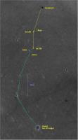
Here is an updated map of the road to Vostok.
Attached thumbnail(s)
|
|
 |
 
|
|
 |
|
Aug 21 2006, 01:47 AM
Post
#2
|
|
 Member Group: Members Posts: 656 Joined: 20-April 05 From: League City, Texas Member No.: 285 |
Best guess at the location of Hawking Rock:
http://www.clarkandersen.com/R1500822_NWVi...mpp_Hawking.PNG (big file, about 4.5 Megs, uncompressed) This is a rescaled version of image R1500822 (the map projected version), scaled to 0.5 meters per pixel. It seems in reasonable agreement with the azimuths as reported by the AlgorimancerPG application. I managed to find a single image showing Hawking from Sol 887, combined with another from Sol 904, yielding about an 80 meter baseline. Performed wide baseline photogrammetry to Hawking to yield the single-pixel hilighted positions. Results of 4 calculations are shown (single colored pixels). I would lean towards the lower two "corrected azimuth" versions (w/corrections referenced to the Twin Peaks yielding +0.33637284 azimuth degrees for Sol 887 and +0.086453315 azimuth degrees for Sol 904 (azimuth correction will be available in APG 3.3, not yet posted). I would allow a bit of leeway in the east-west dimension to allow for error in the image projection, but feel pretty confident about the north-south position (to within a few meters). Bearing in mind that illumination is from the left in this image, several features immediately east and west of the lower two pixel positions may in fact be Hawking, but for the moment I'm leaning towards the dark E-W linear feature immediately to the left (west) of the lower pixel pair, which terminates at the pixels, as Hawking + shadow. In ImageJ, with the image processed to apply a shadow illuminated from the Northwest, that feature stands out nicely. It would be interesting to look at azimuths to Hawking from more recent Oppy positions, but for now there is some fuzziness in those positions, and no good horizon reference to calibrate the azimuth. |
|
|
|
|
Aug 21 2006, 03:57 AM
Post
#3
|
|
|
Member Group: Members Posts: 477 Joined: 2-March 05 Member No.: 180 |
QUOTE (algorimancer @ Aug 20 2006, 09:47 PM)  Best guess at the location of Hawking Rock: http://www.clarkandersen.com/R1500822_NWVi...mpp_Hawking.PNG (big file, about 4.5 Megs, uncompressed) Just a side note, Irfanview can compress (losslessly) PNG files quite well. Get the Plugins pack and you can use PNGOut, which can really compress PNG files. I ran your file there through Irfanview with PNGOut, and it's down to 2,684,928 bytes. And now back to your regularly scheduled thread.... 
|
|
|
|
 Pando Opportunity Route Map Feb 11 2005, 08:11 AM
 jamescanvin I still don't understand the reason for using ... Jul 21 2006, 12:11 AM
 algorimancer QUOTE (jamescanvin @ Jul 20 2006, 07:11 P... Jul 21 2006, 12:52 AM
 mhoward QUOTE (jamescanvin @ Jul 21 2006, 12:11 A... Jul 21 2006, 12:55 AM jamescanvin Route map updated to sol 885 - Small (2.6m accordi... Jul 21 2006, 09:43 PM hortonheardawho QUOTE (jamescanvin @ Jul 21 2006, 05:43 P... Jul 21 2006, 10:45 PM hortonheardawho Ooops:
Got Before and after mixed up in the super... Jul 21 2006, 11:20 PM Toma B After 6 days we are continuing drive toward Beagle... Jul 27 2006, 12:04 PM antoniseb I'm sure it has been explained somewhere, but ... Jul 27 2006, 12:15 PM Phil Stooke It's the penultimate and ultimate hazcam image... Jul 27 2006, 12:33 PM Toma B QUOTE (antoniseb @ Jul 27 2006, 02:15 PM)... Jul 27 2006, 01:29 PM djellison I'll start a thread for PC Database related st... Jul 27 2006, 01:41 PM climber Sometime, it's nice to sit and look some stats... Jul 27 2006, 05:03 PM jamescanvin Without many of the navcams ploting the 891 positi... Jul 28 2006, 03:04 AM mhoward QUOTE (jamescanvin @ Jul 28 2006, 03:04 A... Jul 29 2006, 09:16 PM Phil Stooke I had it at almost the same place, maybe one red d... Jul 28 2006, 03:17 AM abalone Finally here Jul 28 2006, 11:22 AM dvandorn Well -- not quite there yet. I thought we decided... Jul 29 2006, 05:08 AM Tesheiner Glad to see the rover almost at Beagle Crater.
No,... Jul 29 2006, 09:43 PM RNeuhaus Now opportunity is sitting about 25 meters (82 fee... Jul 31 2006, 07:41 PM dot.dk QUOTE (RNeuhaus @ Jul 31 2006, 09:41 PM) ... Aug 1 2006, 12:31 AM RNeuhaus QUOTE (dot.dk @ Jul 31 2006, 07:31 PM) No... Aug 1 2006, 10:57 PM CosmicRocker RE: Opportunity Route Map Aug 1 2006, 05:00 AM climber 200.000 hits on this topic...but only a month to g... Aug 1 2006, 05:50 PM Holder of the Two Leashes QUOTE (climber @ Aug 1 2006, 12:50 PM) 20... Aug 1 2006, 07:49 PM akuo Over how? Manouvering around Victoria is going to ... Aug 1 2006, 08:04 PM dshaffer QUOTE (akuo @ Aug 1 2006, 03:04 PM) Over ... Aug 1 2006, 09:56 PM climber Oups! I thought I was in "going South to ... Aug 1 2006, 08:59 PM Bill Harris QUOTE The navigation direction would be close to S... Aug 1 2006, 11:27 PM diane QUOTE (Bill Harris @ Aug 1 2006, 07:27 PM... Aug 1 2006, 11:40 PM jamescanvin Note that 108 degrees doen't really mean anyth... Aug 1 2006, 11:56 PM RNeuhaus QUOTE (jamescanvin @ Aug 1 2006, 06:56 PM... Aug 2 2006, 02:25 PM jamescanvin Some tracking data is up for 896!
We've ... Aug 2 2006, 12:24 AM jamescanvin Route map for Sol 896. Aug 2 2006, 02:42 AM jamescanvin Sol 898 route map.
A short drive to position Op... Aug 4 2006, 02:49 AM CosmicRocker I hope you have an enjoyable respite, and thanks f... Aug 4 2006, 04:39 AM Sunspot I wonder if they'll drive further to the right... Aug 4 2006, 11:31 AM Phil Stooke My guess is that Opportunity will head east toward... Aug 4 2006, 05:07 PM fredk My own guess of the best approach to VC would be d... Aug 4 2006, 07:22 PM Bill Harris I'd go for the naming of names on the Route Ma... Aug 4 2006, 08:27 PM Phil Stooke My map - which has been posted here before in a re... Aug 4 2006, 08:34 PM Pavel QUOTE (Phil Stooke @ Aug 4 2006, 04:34 PM... Aug 6 2006, 03:29 PM Phil Stooke OK, it's over in the Spirit area.
Phil Aug 6 2006, 04:40 PM algorimancer Just FYI, especially for the benefit of the mapper... Aug 8 2006, 01:21 PM gregp1962 Wasn't today a drve sol? Aug 8 2006, 11:16 PM RNeuhaus QUOTE (gregp1962 @ Aug 8 2006, 06:16 PM) ... Aug 9 2006, 01:13 AM djellison QUOTE (RNeuhaus @ Aug 9 2006, 02:13 AM) T... Aug 9 2006, 07:07 AM dot.dk http://www.newscientistspace.com/article/d...good-... Aug 9 2006, 12:40 PM djellison 5 days - sounds like one thorough IDD campaign to ... Aug 9 2006, 12:51 PM Pando Here's a nice map (a bit old though). Not sure... Aug 12 2006, 12:45 AM ElkGroveDan QUOTE (Pando @ Aug 11 2006, 04:45 PM) Her... Aug 12 2006, 04:24 AM CosmicRocker No, we haven't! ...and it's a keeper.... Aug 12 2006, 04:05 AM aldo12xu QUOTE (CosmicRocker @ Aug 12 2006, 04:05 ... Aug 12 2006, 05:15 AM CosmicRocker Good to see you on the hunt, aldo12xu. This n... Aug 12 2006, 06:59 AM djellison That image is from the S11 phase of MGS ops, so it... Aug 12 2006, 07:57 AM Bill Harris Thanks, Pando. I thought this was one of Phil... Aug 12 2006, 10:17 AM CosmicRocker 907 looks like roughly a twenty meter drive almost... Aug 14 2006, 01:44 AM Phil Stooke ...and here's my version.
Phil
(PS I... Aug 14 2006, 02:36 AM CosmicRocker Damn! You don't know how relieved I am to... Aug 14 2006, 04:35 AM RNeuhaus QUOTE (CosmicRocker @ Aug 13 2006, 11:35 ... Aug 14 2006, 04:41 PM Nirgal QUOTE (RNeuhaus @ Aug 14 2006, 06:41 PM) ... Aug 14 2006, 05:34 PM algorimancer Worst case, we ought to be able to triangulate off... Aug 14 2006, 06:05 PM Tesheiner QUOTE (algorimancer @ Aug 14 2006, 08:05 ... Aug 17 2006, 12:52 PM Bill Harris Navigation on the ejecta blanket shouldn't be ... Aug 14 2006, 07:58 PM Phil Stooke It looks as if my Sol 907 location was based on mi... Aug 15 2006, 03:16 AM CosmicRocker nah, it can't be too significant. There are o... Aug 15 2006, 06:02 AM Phil Stooke It's about this much...
http://marsrovers.jpl... Aug 15 2006, 12:54 PM hortonheardawho estimated sol 909 position:
This is based on t... Aug 15 2006, 01:40 PM Phil Stooke They said they wanted to look at one of the banded... Aug 15 2006, 02:21 PM hortonheardawho QUOTE (Phil Stooke @ Aug 15 2006, 10:21 A... Aug 15 2006, 03:26 PM RNeuhaus QUOTE (hortonheardawho @ Aug 15 2006, 10... Aug 15 2006, 04:26 PM djellison Perhaps characterise the dune material in this reg... Aug 15 2006, 02:30 PM mhoward QUOTE (djellison @ Aug 15 2006, 02:30 PM)... Aug 15 2006, 03:03 PM dilo QUOTE (mhoward @ Aug 15 2006, 03:03 PM) H... Aug 15 2006, 04:05 PM mhoward QUOTE (dilo @ Aug 15 2006, 04:05 PM) (Mic... Aug 15 2006, 04:21 PM Phil Stooke Latest map update.
Phil
Aug 16 2006, 12:40 AM Tesheiner Ok, here we go again. My route map, updated to sol... Aug 18 2006, 08:53 PM algorimancer QUOTE (Tesheiner @ Aug 18 2006, 03:53 PM)... Aug 18 2006, 09:18 PM Tesheiner QUOTE (algorimancer @ Aug 18 2006, 11:18 ... Aug 20 2006, 02:07 PM helvick QUOTE (Tesheiner @ Aug 20 2006, 03:07 PM)... Aug 20 2006, 03:03 PM climber QUOTE (Tesheiner @ Aug 20 2006, 04:07 PM)... Aug 20 2006, 04:57 PM algorimancer QUOTE (Tesheiner @ Aug 20 2006, 09:07 AM)... Aug 20 2006, 09:13 PM climber QUOTE (algorimancer @ Aug 20 2006, 11:13 ... Aug 20 2006, 09:23 PM djellison QUOTE (climber @ Aug 20 2006, 10:23 PM) S... Aug 20 2006, 09:40 PM mcaplinger QUOTE (djellison @ Aug 20 2006, 02:40 PM)... Aug 21 2006, 04:34 AM mcaplinger QUOTE (algorimancer @ Aug 20 2006, 02:13 ... Aug 21 2006, 04:30 AM Phil Stooke Here is the latest version of my total route map. ... Aug 20 2006, 06:04 PM climber QUOTE (Phil Stooke @ Aug 20 2006, 08:04 P... Aug 20 2006, 09:04 PM algorimancer QUOTE (Phil Stooke @ Aug 20 2006, 01:04 P... Aug 20 2006, 09:06 PM Tesheiner QUOTE (algorimancer @ Aug 20 2006, 11:06 ... Aug 21 2006, 07:13 AM Phil Stooke Helvick: "What's the Martian for Va Va V... Aug 20 2006, 06:10 PM fredk A drive to Vicky via Epsilon will help us keep our... Aug 20 2006, 07:07 PM Bill Harris QUOTE Anyone else notice that the Twin Peaks (crat... Aug 20 2006, 10:10 PM gregp1962 After only 2 days of driving since leaving Beagle,... Aug 20 2006, 10:25 PM Phil Stooke "Phil, I notice that since entering the eject... Aug 20 2006, 11:56 PM RNeuhaus After reading the planetary.org report about MER, ... Aug 21 2006, 03:24 AM glennwsmith I'm a little late, Phil, but your composite ro... Aug 21 2006, 04:44 AM
mhoward QUOTE (jamescanvin @ Jul 21 2006, 12:11 A... Jul 21 2006, 12:55 AM jamescanvin Route map updated to sol 885 - Small (2.6m accordi... Jul 21 2006, 09:43 PM hortonheardawho QUOTE (jamescanvin @ Jul 21 2006, 05:43 P... Jul 21 2006, 10:45 PM hortonheardawho Ooops:
Got Before and after mixed up in the super... Jul 21 2006, 11:20 PM Toma B After 6 days we are continuing drive toward Beagle... Jul 27 2006, 12:04 PM antoniseb I'm sure it has been explained somewhere, but ... Jul 27 2006, 12:15 PM Phil Stooke It's the penultimate and ultimate hazcam image... Jul 27 2006, 12:33 PM Toma B QUOTE (antoniseb @ Jul 27 2006, 02:15 PM)... Jul 27 2006, 01:29 PM djellison I'll start a thread for PC Database related st... Jul 27 2006, 01:41 PM climber Sometime, it's nice to sit and look some stats... Jul 27 2006, 05:03 PM jamescanvin Without many of the navcams ploting the 891 positi... Jul 28 2006, 03:04 AM mhoward QUOTE (jamescanvin @ Jul 28 2006, 03:04 A... Jul 29 2006, 09:16 PM Phil Stooke I had it at almost the same place, maybe one red d... Jul 28 2006, 03:17 AM abalone Finally here Jul 28 2006, 11:22 AM dvandorn Well -- not quite there yet. I thought we decided... Jul 29 2006, 05:08 AM Tesheiner Glad to see the rover almost at Beagle Crater.
No,... Jul 29 2006, 09:43 PM RNeuhaus Now opportunity is sitting about 25 meters (82 fee... Jul 31 2006, 07:41 PM dot.dk QUOTE (RNeuhaus @ Jul 31 2006, 09:41 PM) ... Aug 1 2006, 12:31 AM RNeuhaus QUOTE (dot.dk @ Jul 31 2006, 07:31 PM) No... Aug 1 2006, 10:57 PM CosmicRocker RE: Opportunity Route Map Aug 1 2006, 05:00 AM climber 200.000 hits on this topic...but only a month to g... Aug 1 2006, 05:50 PM Holder of the Two Leashes QUOTE (climber @ Aug 1 2006, 12:50 PM) 20... Aug 1 2006, 07:49 PM akuo Over how? Manouvering around Victoria is going to ... Aug 1 2006, 08:04 PM dshaffer QUOTE (akuo @ Aug 1 2006, 03:04 PM) Over ... Aug 1 2006, 09:56 PM climber Oups! I thought I was in "going South to ... Aug 1 2006, 08:59 PM Bill Harris QUOTE The navigation direction would be close to S... Aug 1 2006, 11:27 PM diane QUOTE (Bill Harris @ Aug 1 2006, 07:27 PM... Aug 1 2006, 11:40 PM jamescanvin Note that 108 degrees doen't really mean anyth... Aug 1 2006, 11:56 PM RNeuhaus QUOTE (jamescanvin @ Aug 1 2006, 06:56 PM... Aug 2 2006, 02:25 PM jamescanvin Some tracking data is up for 896!
We've ... Aug 2 2006, 12:24 AM jamescanvin Route map for Sol 896. Aug 2 2006, 02:42 AM jamescanvin Sol 898 route map.
A short drive to position Op... Aug 4 2006, 02:49 AM CosmicRocker I hope you have an enjoyable respite, and thanks f... Aug 4 2006, 04:39 AM Sunspot I wonder if they'll drive further to the right... Aug 4 2006, 11:31 AM Phil Stooke My guess is that Opportunity will head east toward... Aug 4 2006, 05:07 PM fredk My own guess of the best approach to VC would be d... Aug 4 2006, 07:22 PM Bill Harris I'd go for the naming of names on the Route Ma... Aug 4 2006, 08:27 PM Phil Stooke My map - which has been posted here before in a re... Aug 4 2006, 08:34 PM Pavel QUOTE (Phil Stooke @ Aug 4 2006, 04:34 PM... Aug 6 2006, 03:29 PM Phil Stooke OK, it's over in the Spirit area.
Phil Aug 6 2006, 04:40 PM algorimancer Just FYI, especially for the benefit of the mapper... Aug 8 2006, 01:21 PM gregp1962 Wasn't today a drve sol? Aug 8 2006, 11:16 PM RNeuhaus QUOTE (gregp1962 @ Aug 8 2006, 06:16 PM) ... Aug 9 2006, 01:13 AM djellison QUOTE (RNeuhaus @ Aug 9 2006, 02:13 AM) T... Aug 9 2006, 07:07 AM dot.dk http://www.newscientistspace.com/article/d...good-... Aug 9 2006, 12:40 PM djellison 5 days - sounds like one thorough IDD campaign to ... Aug 9 2006, 12:51 PM Pando Here's a nice map (a bit old though). Not sure... Aug 12 2006, 12:45 AM ElkGroveDan QUOTE (Pando @ Aug 11 2006, 04:45 PM) Her... Aug 12 2006, 04:24 AM CosmicRocker No, we haven't! ...and it's a keeper.... Aug 12 2006, 04:05 AM aldo12xu QUOTE (CosmicRocker @ Aug 12 2006, 04:05 ... Aug 12 2006, 05:15 AM CosmicRocker Good to see you on the hunt, aldo12xu. This n... Aug 12 2006, 06:59 AM djellison That image is from the S11 phase of MGS ops, so it... Aug 12 2006, 07:57 AM Bill Harris Thanks, Pando. I thought this was one of Phil... Aug 12 2006, 10:17 AM CosmicRocker 907 looks like roughly a twenty meter drive almost... Aug 14 2006, 01:44 AM Phil Stooke ...and here's my version.
Phil
(PS I... Aug 14 2006, 02:36 AM CosmicRocker Damn! You don't know how relieved I am to... Aug 14 2006, 04:35 AM RNeuhaus QUOTE (CosmicRocker @ Aug 13 2006, 11:35 ... Aug 14 2006, 04:41 PM Nirgal QUOTE (RNeuhaus @ Aug 14 2006, 06:41 PM) ... Aug 14 2006, 05:34 PM algorimancer Worst case, we ought to be able to triangulate off... Aug 14 2006, 06:05 PM Tesheiner QUOTE (algorimancer @ Aug 14 2006, 08:05 ... Aug 17 2006, 12:52 PM Bill Harris Navigation on the ejecta blanket shouldn't be ... Aug 14 2006, 07:58 PM Phil Stooke It looks as if my Sol 907 location was based on mi... Aug 15 2006, 03:16 AM CosmicRocker nah, it can't be too significant. There are o... Aug 15 2006, 06:02 AM Phil Stooke It's about this much...
http://marsrovers.jpl... Aug 15 2006, 12:54 PM hortonheardawho estimated sol 909 position:
This is based on t... Aug 15 2006, 01:40 PM Phil Stooke They said they wanted to look at one of the banded... Aug 15 2006, 02:21 PM hortonheardawho QUOTE (Phil Stooke @ Aug 15 2006, 10:21 A... Aug 15 2006, 03:26 PM RNeuhaus QUOTE (hortonheardawho @ Aug 15 2006, 10... Aug 15 2006, 04:26 PM djellison Perhaps characterise the dune material in this reg... Aug 15 2006, 02:30 PM mhoward QUOTE (djellison @ Aug 15 2006, 02:30 PM)... Aug 15 2006, 03:03 PM dilo QUOTE (mhoward @ Aug 15 2006, 03:03 PM) H... Aug 15 2006, 04:05 PM mhoward QUOTE (dilo @ Aug 15 2006, 04:05 PM) (Mic... Aug 15 2006, 04:21 PM Phil Stooke Latest map update.
Phil
Aug 16 2006, 12:40 AM Tesheiner Ok, here we go again. My route map, updated to sol... Aug 18 2006, 08:53 PM algorimancer QUOTE (Tesheiner @ Aug 18 2006, 03:53 PM)... Aug 18 2006, 09:18 PM Tesheiner QUOTE (algorimancer @ Aug 18 2006, 11:18 ... Aug 20 2006, 02:07 PM helvick QUOTE (Tesheiner @ Aug 20 2006, 03:07 PM)... Aug 20 2006, 03:03 PM climber QUOTE (Tesheiner @ Aug 20 2006, 04:07 PM)... Aug 20 2006, 04:57 PM algorimancer QUOTE (Tesheiner @ Aug 20 2006, 09:07 AM)... Aug 20 2006, 09:13 PM climber QUOTE (algorimancer @ Aug 20 2006, 11:13 ... Aug 20 2006, 09:23 PM djellison QUOTE (climber @ Aug 20 2006, 10:23 PM) S... Aug 20 2006, 09:40 PM mcaplinger QUOTE (djellison @ Aug 20 2006, 02:40 PM)... Aug 21 2006, 04:34 AM mcaplinger QUOTE (algorimancer @ Aug 20 2006, 02:13 ... Aug 21 2006, 04:30 AM Phil Stooke Here is the latest version of my total route map. ... Aug 20 2006, 06:04 PM climber QUOTE (Phil Stooke @ Aug 20 2006, 08:04 P... Aug 20 2006, 09:04 PM algorimancer QUOTE (Phil Stooke @ Aug 20 2006, 01:04 P... Aug 20 2006, 09:06 PM Tesheiner QUOTE (algorimancer @ Aug 20 2006, 11:06 ... Aug 21 2006, 07:13 AM Phil Stooke Helvick: "What's the Martian for Va Va V... Aug 20 2006, 06:10 PM fredk A drive to Vicky via Epsilon will help us keep our... Aug 20 2006, 07:07 PM Bill Harris QUOTE Anyone else notice that the Twin Peaks (crat... Aug 20 2006, 10:10 PM gregp1962 After only 2 days of driving since leaving Beagle,... Aug 20 2006, 10:25 PM Phil Stooke "Phil, I notice that since entering the eject... Aug 20 2006, 11:56 PM RNeuhaus After reading the planetary.org report about MER, ... Aug 21 2006, 03:24 AM glennwsmith I'm a little late, Phil, but your composite ro... Aug 21 2006, 04:44 AM |

|
Lo-Fi Version | Time is now: 22nd September 2024 - 03:44 AM |
|
RULES AND GUIDELINES Please read the Forum Rules and Guidelines before posting. IMAGE COPYRIGHT |
OPINIONS AND MODERATION Opinions expressed on UnmannedSpaceflight.com are those of the individual posters and do not necessarily reflect the opinions of UnmannedSpaceflight.com or The Planetary Society. The all-volunteer UnmannedSpaceflight.com moderation team is wholly independent of The Planetary Society. The Planetary Society has no influence over decisions made by the UnmannedSpaceflight.com moderators. |
SUPPORT THE FORUM Unmannedspaceflight.com is funded by the Planetary Society. Please consider supporting our work and many other projects by donating to the Society or becoming a member. |
|