SMART-1 impact, September 2006 |

SMART-1 impact, September 2006 |
 Mar 16 2006, 05:26 PM Mar 16 2006, 05:26 PM
Post
#1
|
||
|
Solar System Cartographer  Group: Members Posts: 10196 Joined: 5-April 05 From: Canada Member No.: 227 |
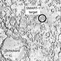
Emily posted a very nice article in her blog on the SMART-1 lunar impact in September this year. Here's a map of the targeted point:
But as Emily explained, the actual point may be off because of uncertainties about topography. I'm starting this thread to have a place for news and opinions on it, and - I really hope - maybe some observations at the time from any amateur astronomers out there. This event will be the last event to make it into my atlas. I've left a space for it, and I will make the final maps and fit them in, and then send the stuff off to the publisher. Phil -------------------- ... because the Solar System ain't gonna map itself.
Also to be found posting similar content on https://mastodon.social/@PhilStooke Maps for download (free PD: https://upload.wikimedia.org/wikipedia/comm...Cartography.pdf NOTE: everything created by me which I post on UMSF is considered to be in the public domain (NOT CC, public domain) |
|
 |
 
|
|
 |
|
Sep 5 2006, 02:11 PM
Post
#2
|
||
|
Solar System Cartographer Group: Members Posts: 10196 Joined: 5-April 05 From: Canada Member No.: 227 |
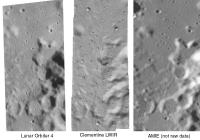
Here is a side by side comparison of an area immediately to the west of the SMART-1 impact point (west of it because the Clementine image doesn't cross the impact site itself).
I'm comparing Lunar Orbiter 4 - the new USGS digital version - with Clementine long-wavelength infrared (LWIR) and AMIE. Warning - this is not a fair comparison for AMIE because it's not raw data. This is just cropped out of the big mosaic of the landing area recently posted. This shows LO4 and Clem at full resolution. The AMIE image is enlarged to match the scale, hence its fuzziness. It is possible that raw AMIE images would equal the resolution of the other two, or get fairly close, near the periapsis latitude. A few other points can be made - the lighting is reversed from Lunar Orbiter, so areas lost in shadow in Orbiter will be seen in AMIE and vice versa - especially important near the poles. And Orbiter coverage of the farside is inferior to this nearside area, so AMIE will at least equal it in many areas. And the Clem LWIR is only available in narrow strips. So we benefit most by having access to all three types of image. AMIE apparently took 20,000 images. When they are released - and especially if good global mosaics are constructed - they will be a very useful addition to lunar databases. And let's not forget that, although several other orbiters are planned, we don't know how many will actually fly successfully. Phil
-------------------- ... because the Solar System ain't gonna map itself.
Also to be found posting similar content on https://mastodon.social/@PhilStooke Maps for download (free PD: https://upload.wikimedia.org/wikipedia/comm...Cartography.pdf NOTE: everything created by me which I post on UMSF is considered to be in the public domain (NOT CC, public domain) |
|
|
|
|
|
 Phil Stooke SMART-1 impact Mar 16 2006, 05:26 PM
 ljk4-1 The March 16 edition of LPOD has an image of the S... Mar 16 2006, 08:41 PM
 AlexBlackwell QUOTE (ljk4-1 @ Mar 16 2006, 08:41 P... Mar 16 2006, 08:50 PM
 Bob Shaw QUOTE (ljk4-1 @ Mar 16 2006, 08:41 P... Mar 16 2006, 09:05 PM The Messenger QUOTE (Bob Shaw @ Mar 16 2006, 02:05 PM) ... Mar 24 2006, 07:15 PM djellison Somehow, they get away with that excuse across the... Mar 16 2006, 09:06 PM helvick QUOTE (djellison @ Mar 16 2006, 09:06 PM)... Mar 17 2006, 12:35 AM odave SMART-1 @ Home? Mar 16 2006, 09:07 PM djellison What we need is Esawatch - I'm not a Cowing f... Mar 17 2006, 08:34 AM AlexBlackwell QUOTE (djellison @ Mar 17 2006, 08:34 AM)... Mar 17 2006, 05:13 PM J.J. I'm not optimistic about the results; I'm ... Mar 22 2006, 04:03 AM Phil Stooke A very good question.
There is general agreemen... Mar 22 2006, 04:27 AM ljk4-1 QUOTE (Phil Stooke @ Mar 21 2006, 11:27 P... Mar 22 2006, 12:37 PM J.J. Thanks for the answers, people. Mar 24 2006, 05:10 AM Phil Stooke Very useful new report on the impact:
http://sci.... Mar 24 2006, 04:44 PM Phil Stooke This map shows the target locations from the repor... Mar 26 2006, 03:54 PM RNeuhaus QUOTE (Phil Stooke @ Mar 26 2006, 10:54 A... Mar 26 2006, 05:22 PM helvick QUOTE (RNeuhaus @ Mar 26 2006, 05:22 PM) ... Mar 26 2006, 05:35 PM dvandorn So, like, they're gonna crash it into, like, L... Mar 26 2006, 03:57 PM Phil Stooke I prefer a Mr Burns-style "Eeeeexcellent... Mar 26 2006, 04:37 PM elakdawalla ESA press release today:
SMART-1 manoeuvres prepar... Jun 23 2006, 09:03 PM garybeau QUOTE (elakdawalla @ Jun 23 2006, 05:03 P... Jun 25 2006, 10:42 PM Bob Shaw QUOTE (garybeau @ Jun 25 2006, 11:42 PM) ... Jun 25 2006, 11:29 PM Rakhir Final operational report for the SMART-1 mission.
... Jun 23 2006, 09:19 PM edstrick It's "nice" but not always "nec... Jun 29 2006, 02:29 AM AlexBlackwell SMART-1 towards final impact
European Space Agency... Aug 4 2006, 08:12 PM rogelio Any harm for the Moon?
Nearly 50 years ago, in ... Aug 4 2006, 10:59 PM ljk4-1 QUOTE (rogelio @ Aug 4 2006, 06:59 PM) ..... Aug 4 2006, 11:49 PM DonPMitchell James Oberg had an article some time ago about rad... Aug 6 2006, 06:44 PM tedstryk QUOTE (DonPMitchell @ Aug 6 2006, 06:44 P... Aug 7 2006, 03:48 PM DonPMitchell QUOTE (tedstryk @ Aug 7 2006, 08:48 AM) I... Aug 11 2006, 07:29 PM ljk4-1 Lunar research opportunity
As many of you are awa... Aug 10 2006, 03:11 PM ljk4-1 NEWS RELEASE
For immediate release: 2006 July 18
... Aug 11 2006, 02:11 PM DonPMitchell How does the resolution and coverage from SMART-1 ... Aug 11 2006, 07:33 PM Phil Stooke Don, the SMART-1 images will be a good source of m... Aug 11 2006, 07:48 PM DonPMitchell Looking forward do it. For computer rendering of ... Aug 11 2006, 08:20 PM Phil Stooke That certainly works for computer rendering, but a... Aug 11 2006, 08:31 PM DonPMitchell In theory, with overhead-lit and side-lit views, y... Aug 12 2006, 07:59 AM Valmir Martins de Morais UPDATE FOR THE LUNAR IMPACT OF THE SMART-1
Dear C... Aug 12 2006, 05:12 PM Phil Stooke Latest news:
http://www.esa.int/esaCP/SEMTU0Z7QQE... Aug 17 2006, 02:33 PM djellison Looking at Stellarium, (and I'm guessing it... Aug 18 2006, 07:59 PM Phil Stooke Latest news - Star Tracker images:
http://www.esa... Aug 30 2006, 01:36 PM ugordan What puzzles me is that the star tracker images ap... Aug 30 2006, 01:52 PM dilo QUOTE (Phil Stooke @ Aug 30 2006, 01:36 P... Aug 30 2006, 08:29 PM Phil Stooke There might be a difference between what the camer... Aug 30 2006, 03:21 PM RNeuhaus Will SMART-1 impact around the initially planned z... Aug 30 2006, 05:18 PM ljk4-1 Some more undistorted (?) images from the star tra... Aug 30 2006, 05:42 PM Phil Stooke Rodolfo asked about the impact area - it's sti... Aug 30 2006, 06:08 PM RNeuhaus Many thanks for sharing us. What ways will confirm... Aug 30 2006, 07:03 PM climber QUOTE (RNeuhaus @ Aug 30 2006, 09:03 PM) ... Aug 30 2006, 08:28 PM Phil Stooke Updating on the impact point: here:
http://sci.e... Aug 30 2006, 09:23 PM ustrax Foreseen operational duration:
2-2.5 years
Well..... Aug 31 2006, 09:09 AM ljk4-1 Some Italian radio astronomers are conducting live... Aug 31 2006, 02:27 PM dilo QUOTE (ljk4-1 @ Aug 31 2006, 02:27 P... Sep 2 2006, 09:14 AM mars loon A new ESA update today, as SMART-1 recovers from a... Sep 2 2006, 06:09 PM RNeuhaus QUOTE (dilo @ Sep 2 2006, 04:14 AM) They ... Sep 2 2006, 06:19 PM Rakhir An animation made of some star tracker images from... Sep 2 2006, 09:55 PM Phil Stooke Nice. The bright crater they mention is Aristarch... Sep 2 2006, 11:46 PM Phil Stooke This is Clementine long wavelength infrared - the ... Sep 2 2006, 11:54 PM mars loon A new update from Spaceflightnow.com
http://www.sp... Sep 3 2006, 12:58 AM Phil Stooke Well, unfortunately the Clementine LWIR image stri... Sep 3 2006, 04:14 AM MizarKey Does anyone know if there's anywhere on the we... Sep 3 2006, 05:29 AM GravityWaves QUOTE (MizarKey @ Sep 3 2006, 02:29 AM) D... Sep 3 2006, 05:51 AM ermar According to the ESA, the impact took place accord... Sep 3 2006, 06:10 AM CosmicRocker I've been chasing the news, but it has been sc... Sep 3 2006, 07:05 AM Jyril The CFHT image of the flash is available here. Sep 3 2006, 08:29 AM dilo Thanks, Jyril... I suspect these are the very firs... Sep 3 2006, 09:50 AM ugordan I suspect the brightness of the flash will be much... Sep 3 2006, 10:30 AM Sunspot The impact site would be a good target for the fut... Sep 3 2006, 10:44 AM edstrick Given the low impact speed, this is *not* a hyperv... Sep 3 2006, 11:44 AM hal_9000 SMART-1 on IFR
http://www.cfht.hawaii.edu/News/Sma... Sep 3 2006, 11:55 AM mars loon There are some brief reports at the Planetary soci... Sep 3 2006, 12:28 PM Myran I can only confirm whats been said, but yes the Sw... Sep 3 2006, 12:42 PM Phil Stooke I was just thinking about how many things have hit... Sep 3 2006, 03:47 PM garybeau Not sure if the telescope/camera has the resolutio... Sep 3 2006, 05:49 PM djellison The crater is expected to be 3 x 10m..... you... Sep 3 2006, 05:55 PM garybeau True, the actual crater may not be visible, but th... Sep 3 2006, 06:07 PM ustrax QUOTE (garybeau @ Sep 3 2006, 07:07 PM) T... Sep 6 2006, 01:13 PM Phil Stooke The Apollo 14 LM ascent stage impacted in a mare a... Sep 3 2006, 06:41 PM RNeuhaus Approximate impact zone:
The impact region lies a... Sep 3 2006, 06:53 PM garybeau From Space.com article.
"Dust and other mate... Sep 3 2006, 07:05 PM tty QUOTE (garybeau @ Sep 3 2006, 09:05 PM) F... Sep 3 2006, 07:28 PM Phil Stooke It's not easy to compare the CFHT image of the... Sep 4 2006, 02:21 AM remcook some more stuff, including some movies:
http://ww... Sep 4 2006, 03:23 PM Phil Stooke This is my current SMART-1 map, as I understand it... Sep 4 2006, 07:42 PM remcook Fig 363? I am looking forward to your book! I... Sep 4 2006, 08:00 PM RNeuhaus It is evident that Clementine LWIR has better pict... Sep 5 2006, 03:44 PM djellison QUOTE (RNeuhaus @ Sep 5 2006, 04:44 PM) d... Sep 5 2006, 03:48 PM RNeuhaus QUOTE (djellison @ Sep 5 2006, 10:48 AM) ... Sep 5 2006, 03:58 PM djellison Well - I'll still ask the same question - why ... Sep 5 2006, 03:59 PM RNeuhaus QUOTE (djellison @ Sep 5 2006, 10:59 AM) ... Sep 5 2006, 04:16 PM Stu One for British Forum members...
SMART 1's la... Sep 5 2006, 04:23 PM paxdan QUOTE (Stu @ Sep 5 2006, 05:23 PM) One fo... Sep 5 2006, 04:27 PM Stu Don't be silly. Button Moon was just puppets. ... Sep 5 2006, 04:35 PM paxdan QUOTE (Stu @ Sep 5 2006, 05:35 PM) Don... Sep 5 2006, 04:54 PM Stu QUOTE (paxdan @ Sep 5 2006, 04:54 PM) noo... Sep 5 2006, 05:01 PM helvick QUOTE (Stu @ Sep 5 2006, 06:01 PM) (... Sep 5 2006, 06:43 PM djellison I was about to say... How do you know it's cha... Sep 6 2006, 01:26 PM remcook is that a simple differencing of the images wrt th... Sep 6 2006, 01:34 PM
Bob Shaw QUOTE (ljk4-1 @ Mar 16 2006, 08:41 P... Mar 16 2006, 09:05 PM The Messenger QUOTE (Bob Shaw @ Mar 16 2006, 02:05 PM) ... Mar 24 2006, 07:15 PM djellison Somehow, they get away with that excuse across the... Mar 16 2006, 09:06 PM helvick QUOTE (djellison @ Mar 16 2006, 09:06 PM)... Mar 17 2006, 12:35 AM odave SMART-1 @ Home? Mar 16 2006, 09:07 PM djellison What we need is Esawatch - I'm not a Cowing f... Mar 17 2006, 08:34 AM AlexBlackwell QUOTE (djellison @ Mar 17 2006, 08:34 AM)... Mar 17 2006, 05:13 PM J.J. I'm not optimistic about the results; I'm ... Mar 22 2006, 04:03 AM Phil Stooke A very good question.
There is general agreemen... Mar 22 2006, 04:27 AM ljk4-1 QUOTE (Phil Stooke @ Mar 21 2006, 11:27 P... Mar 22 2006, 12:37 PM J.J. Thanks for the answers, people. Mar 24 2006, 05:10 AM Phil Stooke Very useful new report on the impact:
http://sci.... Mar 24 2006, 04:44 PM Phil Stooke This map shows the target locations from the repor... Mar 26 2006, 03:54 PM RNeuhaus QUOTE (Phil Stooke @ Mar 26 2006, 10:54 A... Mar 26 2006, 05:22 PM helvick QUOTE (RNeuhaus @ Mar 26 2006, 05:22 PM) ... Mar 26 2006, 05:35 PM dvandorn So, like, they're gonna crash it into, like, L... Mar 26 2006, 03:57 PM Phil Stooke I prefer a Mr Burns-style "Eeeeexcellent... Mar 26 2006, 04:37 PM elakdawalla ESA press release today:
SMART-1 manoeuvres prepar... Jun 23 2006, 09:03 PM garybeau QUOTE (elakdawalla @ Jun 23 2006, 05:03 P... Jun 25 2006, 10:42 PM Bob Shaw QUOTE (garybeau @ Jun 25 2006, 11:42 PM) ... Jun 25 2006, 11:29 PM Rakhir Final operational report for the SMART-1 mission.
... Jun 23 2006, 09:19 PM edstrick It's "nice" but not always "nec... Jun 29 2006, 02:29 AM AlexBlackwell SMART-1 towards final impact
European Space Agency... Aug 4 2006, 08:12 PM rogelio Any harm for the Moon?
Nearly 50 years ago, in ... Aug 4 2006, 10:59 PM ljk4-1 QUOTE (rogelio @ Aug 4 2006, 06:59 PM) ..... Aug 4 2006, 11:49 PM DonPMitchell James Oberg had an article some time ago about rad... Aug 6 2006, 06:44 PM tedstryk QUOTE (DonPMitchell @ Aug 6 2006, 06:44 P... Aug 7 2006, 03:48 PM DonPMitchell QUOTE (tedstryk @ Aug 7 2006, 08:48 AM) I... Aug 11 2006, 07:29 PM ljk4-1 Lunar research opportunity
As many of you are awa... Aug 10 2006, 03:11 PM ljk4-1 NEWS RELEASE
For immediate release: 2006 July 18
... Aug 11 2006, 02:11 PM DonPMitchell How does the resolution and coverage from SMART-1 ... Aug 11 2006, 07:33 PM Phil Stooke Don, the SMART-1 images will be a good source of m... Aug 11 2006, 07:48 PM DonPMitchell Looking forward do it. For computer rendering of ... Aug 11 2006, 08:20 PM Phil Stooke That certainly works for computer rendering, but a... Aug 11 2006, 08:31 PM DonPMitchell In theory, with overhead-lit and side-lit views, y... Aug 12 2006, 07:59 AM Valmir Martins de Morais UPDATE FOR THE LUNAR IMPACT OF THE SMART-1
Dear C... Aug 12 2006, 05:12 PM Phil Stooke Latest news:
http://www.esa.int/esaCP/SEMTU0Z7QQE... Aug 17 2006, 02:33 PM djellison Looking at Stellarium, (and I'm guessing it... Aug 18 2006, 07:59 PM Phil Stooke Latest news - Star Tracker images:
http://www.esa... Aug 30 2006, 01:36 PM ugordan What puzzles me is that the star tracker images ap... Aug 30 2006, 01:52 PM dilo QUOTE (Phil Stooke @ Aug 30 2006, 01:36 P... Aug 30 2006, 08:29 PM Phil Stooke There might be a difference between what the camer... Aug 30 2006, 03:21 PM RNeuhaus Will SMART-1 impact around the initially planned z... Aug 30 2006, 05:18 PM ljk4-1 Some more undistorted (?) images from the star tra... Aug 30 2006, 05:42 PM Phil Stooke Rodolfo asked about the impact area - it's sti... Aug 30 2006, 06:08 PM RNeuhaus Many thanks for sharing us. What ways will confirm... Aug 30 2006, 07:03 PM climber QUOTE (RNeuhaus @ Aug 30 2006, 09:03 PM) ... Aug 30 2006, 08:28 PM Phil Stooke Updating on the impact point: here:
http://sci.e... Aug 30 2006, 09:23 PM ustrax Foreseen operational duration:
2-2.5 years
Well..... Aug 31 2006, 09:09 AM ljk4-1 Some Italian radio astronomers are conducting live... Aug 31 2006, 02:27 PM dilo QUOTE (ljk4-1 @ Aug 31 2006, 02:27 P... Sep 2 2006, 09:14 AM mars loon A new ESA update today, as SMART-1 recovers from a... Sep 2 2006, 06:09 PM RNeuhaus QUOTE (dilo @ Sep 2 2006, 04:14 AM) They ... Sep 2 2006, 06:19 PM Rakhir An animation made of some star tracker images from... Sep 2 2006, 09:55 PM Phil Stooke Nice. The bright crater they mention is Aristarch... Sep 2 2006, 11:46 PM Phil Stooke This is Clementine long wavelength infrared - the ... Sep 2 2006, 11:54 PM mars loon A new update from Spaceflightnow.com
http://www.sp... Sep 3 2006, 12:58 AM Phil Stooke Well, unfortunately the Clementine LWIR image stri... Sep 3 2006, 04:14 AM MizarKey Does anyone know if there's anywhere on the we... Sep 3 2006, 05:29 AM GravityWaves QUOTE (MizarKey @ Sep 3 2006, 02:29 AM) D... Sep 3 2006, 05:51 AM ermar According to the ESA, the impact took place accord... Sep 3 2006, 06:10 AM CosmicRocker I've been chasing the news, but it has been sc... Sep 3 2006, 07:05 AM Jyril The CFHT image of the flash is available here. Sep 3 2006, 08:29 AM dilo Thanks, Jyril... I suspect these are the very firs... Sep 3 2006, 09:50 AM ugordan I suspect the brightness of the flash will be much... Sep 3 2006, 10:30 AM Sunspot The impact site would be a good target for the fut... Sep 3 2006, 10:44 AM edstrick Given the low impact speed, this is *not* a hyperv... Sep 3 2006, 11:44 AM hal_9000 SMART-1 on IFR
http://www.cfht.hawaii.edu/News/Sma... Sep 3 2006, 11:55 AM mars loon There are some brief reports at the Planetary soci... Sep 3 2006, 12:28 PM Myran I can only confirm whats been said, but yes the Sw... Sep 3 2006, 12:42 PM Phil Stooke I was just thinking about how many things have hit... Sep 3 2006, 03:47 PM garybeau Not sure if the telescope/camera has the resolutio... Sep 3 2006, 05:49 PM djellison The crater is expected to be 3 x 10m..... you... Sep 3 2006, 05:55 PM garybeau True, the actual crater may not be visible, but th... Sep 3 2006, 06:07 PM ustrax QUOTE (garybeau @ Sep 3 2006, 07:07 PM) T... Sep 6 2006, 01:13 PM Phil Stooke The Apollo 14 LM ascent stage impacted in a mare a... Sep 3 2006, 06:41 PM RNeuhaus Approximate impact zone:
The impact region lies a... Sep 3 2006, 06:53 PM garybeau From Space.com article.
"Dust and other mate... Sep 3 2006, 07:05 PM tty QUOTE (garybeau @ Sep 3 2006, 09:05 PM) F... Sep 3 2006, 07:28 PM Phil Stooke It's not easy to compare the CFHT image of the... Sep 4 2006, 02:21 AM remcook some more stuff, including some movies:
http://ww... Sep 4 2006, 03:23 PM Phil Stooke This is my current SMART-1 map, as I understand it... Sep 4 2006, 07:42 PM remcook Fig 363? I am looking forward to your book! I... Sep 4 2006, 08:00 PM RNeuhaus It is evident that Clementine LWIR has better pict... Sep 5 2006, 03:44 PM djellison QUOTE (RNeuhaus @ Sep 5 2006, 04:44 PM) d... Sep 5 2006, 03:48 PM RNeuhaus QUOTE (djellison @ Sep 5 2006, 10:48 AM) ... Sep 5 2006, 03:58 PM djellison Well - I'll still ask the same question - why ... Sep 5 2006, 03:59 PM RNeuhaus QUOTE (djellison @ Sep 5 2006, 10:59 AM) ... Sep 5 2006, 04:16 PM Stu One for British Forum members...
SMART 1's la... Sep 5 2006, 04:23 PM paxdan QUOTE (Stu @ Sep 5 2006, 05:23 PM) One fo... Sep 5 2006, 04:27 PM Stu Don't be silly. Button Moon was just puppets. ... Sep 5 2006, 04:35 PM paxdan QUOTE (Stu @ Sep 5 2006, 05:35 PM) Don... Sep 5 2006, 04:54 PM Stu QUOTE (paxdan @ Sep 5 2006, 04:54 PM) noo... Sep 5 2006, 05:01 PM helvick QUOTE (Stu @ Sep 5 2006, 06:01 PM) (... Sep 5 2006, 06:43 PM djellison I was about to say... How do you know it's cha... Sep 6 2006, 01:26 PM remcook is that a simple differencing of the images wrt th... Sep 6 2006, 01:34 PM |

|
Lo-Fi Version | Time is now: 21st June 2024 - 07:43 PM |
|
RULES AND GUIDELINES Please read the Forum Rules and Guidelines before posting. IMAGE COPYRIGHT |
OPINIONS AND MODERATION Opinions expressed on UnmannedSpaceflight.com are those of the individual posters and do not necessarily reflect the opinions of UnmannedSpaceflight.com or The Planetary Society. The all-volunteer UnmannedSpaceflight.com moderation team is wholly independent of The Planetary Society. The Planetary Society has no influence over decisions made by the UnmannedSpaceflight.com moderators. |
SUPPORT THE FORUM Unmannedspaceflight.com is funded by the Planetary Society. Please consider supporting our work and many other projects by donating to the Society or becoming a member. |
|