Victoria - working names of features |

Victoria - working names of features |
 Sep 21 2006, 02:49 AM Sep 21 2006, 02:49 AM
Post
#1
|
|
 Senior Member  Group: Moderator Posts: 2262 Joined: 9-February 04 From: Melbourne - Oz Member No.: 16 |
Very soon
 we're going to have a hell of a lot of features of Victoria to discuss, so I think it's about time we had some way of telling each other which bits we are talking about. (A bit like naming craters Alpha, Beta.. Zeta, etc) we're going to have a hell of a lot of features of Victoria to discuss, so I think it's about time we had some way of telling each other which bits we are talking about. (A bit like naming craters Alpha, Beta.. Zeta, etc)I know Stu started to label a few features, but only a few, and there are A LOT! I've tried to divide Victoria into logical sections and given each a letter. Then within each region I've numbered each point of the rim that appears to bend in the opposite way to the curve of the crater, hence numbering "Capes". Some are quite subtle and therefore may not be seen very well in reality but I think it's better to have them all in there. Here is the map, it is externally linked so should be updated with the latest version. (Now updated with the (half scale) HiRise image)  (Click image for larger version, ~400kB) So: A1 is Cape Verde A2 is The Beacon P4 is Cabo Frio and as of the 943 drive we can see the far rim between E2 and K1. Of course I'm sure that some of the more prominent features will soon acquire more meaningful names, but this should still help us all follow what we're all talking about! Bays are given the same designation as the cape on there 'clockwise side', thus most of the major bays (which tend to separate lettered regions) then have a "1" designation (making the rule easier to remember). Bay A1, where Oppy is heading first is Duck Bay and the bay that Fredk has measured the slope of is Bay I1. Most of the major bays are marked in red. JPL's names are also added, as are their numbered capes and bays - in square brackets. Informal UMSF names are added within round brackets. James -------------------- |
 |
 
|
 |
|
Sep 24 2006, 09:09 AM
Post
#2
|
|||
 The Poet Dude Group: Moderator Posts: 5551 Joined: 15-March 04 From: Kendal, Cumbria, UK Member No.: 60 |
Very nice...
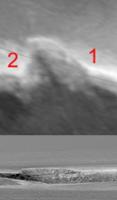
Don't know about anyone else, but I'm ready to get out and give Oppy a push at this point. If you look at the top half of James' latest creation you can see that just below our current line of sight are some very intriguing features... hints of gullies, rock falls, more ledges and structure... and STILL Sofi crater is fascinating me, no-one has yet answered my asked-donkeys'-years-ago question of when it was created, pre- or post-VC impact... any ideas..? Couple of items of interest... I asked this some time ago, but no-obne replied, so I am still wondering if this used to be a Sofi-type impact crater...
... because every other bay has a rim roughly level with the crater's edge, while this one seems to my untrained eyes (correct me if I'm wrong... I'm sure someone will!) to be raised up above that level. Is this a Sofi-type crater that has been eroded away by the wasting process shaping the crater's rim? And is this really a gully...?

-------------------- |
||
|
|
|
||
 jamescanvin Victoria - working names of features Sep 21 2006, 02:49 AM
 Bill Harris Works for me, James.
--Bill Sep 21 2006, 02:55 AM CosmicRocker Coincidentally, Mark Adler (who has been doing a n... Sep 21 2006, 03:05 AM fredk James, I was just trying to think of a temporary n... Sep 21 2006, 03:12 AM
Bill Harris Works for me, James.
--Bill Sep 21 2006, 02:55 AM CosmicRocker Coincidentally, Mark Adler (who has been doing a n... Sep 21 2006, 03:05 AM fredk James, I was just trying to think of a temporary n... Sep 21 2006, 03:12 AM
 jamescanvin QUOTE (fredk @ Sep 21 2006, 01:12 PM) Jam... Sep 21 2006, 03:32 AM fredk QUOTE (jamescanvin @ Sep 21 2006, 03:32 A... Sep 21 2006, 05:56 AM jamescanvin QUOTE (jamescanvin @ Sep 21 2006, 01:32 P... Sep 21 2006, 06:02 AM fredk QUOTE (jamescanvin @ Sep 21 2006, 06:02 A... Sep 21 2006, 03:32 PM Stu QUOTE (jamescanvin @ Sep 21 2006, 02:49 A... Sep 21 2006, 05:30 AM Bill Harris Cape and Bay works, too. We can adopt a temporary... Sep 21 2006, 10:24 AM Castor Does anybody know when the clean (i.e. unlabelled)... Sep 21 2006, 12:06 PM dilo QUOTE (Castor @ Sep 21 2006, 12:06 PM) Do... Sep 22 2006, 05:35 AM Tesheiner For a date I don't know for sure; there was ta... Sep 21 2006, 02:08 PM Bobby I think all the features should be named for all t... Sep 21 2006, 04:02 PM imipak QUOTE (Bobby @ Sep 21 2006, 05:02 PM) I t... Sep 21 2006, 07:25 PM climber QUOTE (imipak @ Sep 21 2006, 09:25 PM) Te... Sep 21 2006, 08:21 PM Stu With all due respect to our Boss, I'm not enti... Sep 21 2006, 04:14 PM Gray Don't forget Bobby. (After all it was his sugg... Sep 21 2006, 07:34 PM djellison Actually - I think we're going down a bit of a... Sep 21 2006, 08:27 PM climber Agree, as I wrote on "Duck Bay" topic, I... Sep 21 2006, 09:46 PM gregp1962 Names do sounds more personal. (Though, I would al... Sep 22 2006, 05:20 AM jamescanvin Thanks for pointing me at your cleaned up image ag... Sep 22 2006, 05:53 AM MizarKey Right! I'm staking a claim to the ledge th... Sep 22 2006, 06:12 AM Stu QUOTE (MizarKey @ Sep 22 2006, 06:12 AM) ... Sep 22 2006, 08:58 AM climber Once we'll have a good shot of them, I'll ... Sep 22 2006, 09:21 AM jamescanvin Here are the labeled Victoria maps using Dilo... Sep 23 2006, 03:58 AM Stu Thanks James, they're going to be invaluable i... Sep 23 2006, 07:15 AM Nix Absolutely! Good work, I made a print of that ... Sep 23 2006, 07:58 AM Stu Okay, just to kill some time here before something... Sep 23 2006, 08:20 AM climber I'll keep the Magellan proposition because :
1... Sep 23 2006, 09:21 AM angel1801 This is my very first post in any MER related foru... Sep 23 2006, 09:25 AM Stu I agree with all your points I'm not suggest... Sep 23 2006, 09:24 AM climber QUOTE (Stu @ Sep 23 2006, 11:24 AM) I agr... Sep 23 2006, 09:54 AM mars loon Marco, James
beautiful map and labeling scheme. ... Sep 23 2006, 10:57 AM CosmicRocker Welcome to the MER corner, angel1801. I think eve... Sep 24 2006, 05:01 AM CosmicRocker I originally came to this thread to post a suggest... Sep 24 2006, 05:26 AM angel1801 I think ethnic groups get enough places for them a... Sep 24 2006, 05:36 AM volcanopele QUOTE (angel1801 @ Sep 23 2006, 10:36 PM)... Sep 24 2006, 04:27 PM jamescanvin QUOTE (CosmicRocker @ Sep 24 2006, 03:26 ... Sep 24 2006, 06:36 AM gregp1962 Doug, I'm thinking that it would a good to hav... Sep 24 2006, 05:46 AM Stu QUOTE (jamescanvin @ Sep 24 2006, 06:36 A... Sep 24 2006, 06:57 AM jamescanvin Thanks Stu, if you liked that, you'll love thi... Sep 24 2006, 08:52 AM mars loon QUOTE (jamescanvin @ Sep 24 2006, 08:52 A... Sep 24 2006, 11:43 PM jamescanvin QUOTE (mars loon @ Sep 25 2006, 09:43 AM)... Sep 25 2006, 12:01 AM fredk James, that last Duck Bay view is superb - thanks... Sep 24 2006, 04:20 PM Shaka QUOTE (fredk @ Sep 24 2006, 06:20 AM) Stu... Sep 24 2006, 07:06 PM diane QUOTE (Shaka @ Sep 24 2006, 03:06 PM) It ... Sep 24 2006, 07:20 PM Reckless Thanks James that latest Duck Bay with labels is g... Sep 24 2006, 04:32 PM jamescanvin I've updated the maps so that north is at the ... Sep 25 2006, 02:52 AM Zeke4ther QUOTE (jamescanvin @ Sep 24 2006, 10:52 P... Sep 25 2006, 07:58 PM Stu I've just started reading RED MARS (yes, again... Sep 25 2006, 09:44 AM jamescanvin QUOTE (Stu @ Sep 25 2006, 07:44 PM) I... Sep 25 2006, 09:31 PM Stu QUOTE (jamescanvin @ Sep 25 2006, 09:31 P... Sep 26 2006, 09:53 AM MahFL I have read all the books Sep 26 2006, 12:07 PM imipak QUOTE (MahFL @ Sep 26 2006, 01:07 PM) I h... Sep 26 2006, 03:53 PM mhoward Has this been noticed? Sep 26 2006, 09:23 PM akuo Too bad the trilogy goes down the drain after abou... Sep 26 2006, 12:28 PM volcanopele hehe, mhoward, confusion reigns!
The MOC and ... Sep 26 2006, 09:53 PM mhoward QUOTE (volcanopele @ Sep 26 2006, 09:53 P... Sep 26 2006, 10:02 PM djellison QUOTE (volcanopele @ Sep 26 2006, 10:53 P... Sep 26 2006, 10:13 PM Stu QUOTE (mhoward @ Sep 26 2006, 10:02 PM) T... Sep 26 2006, 10:25 PM jamescanvin Hmm, I don't think confusion does reign. It... Sep 26 2006, 10:27 PM Castor QUOTE (jamescanvin @ Sep 26 2006, 11:27 P... Sep 27 2006, 09:44 AM volcanopele Well, there is always confusion for a bit when swi... Sep 26 2006, 10:32 PM jamescanvin Well I'll add JPL's names to my map and th... Sep 26 2006, 11:07 PM fredk I think we should definitely continue using James... Sep 26 2006, 11:08 PM RNeuhaus QUOTE (fredk @ Sep 26 2006, 06:08 PM) I t... Sep 27 2006, 02:26 AM Pavel QUOTE (RNeuhaus @ Sep 26 2006, 10:26 PM) ... Sep 27 2006, 02:39 AM Tesheiner QUOTE (fredk @ Sep 27 2006, 01:08 AM) It... Sep 27 2006, 06:52 AM jamescanvin Just to add to fredk's point 2. If JPL continu... Sep 27 2006, 12:01 AM jamescanvin New versions using the clean MOC image that has ju... Sep 27 2006, 07:28 AM Zeke4ther QUOTE (jamescanvin @ Sep 27 2006, 03:28 A... Sep 27 2006, 03:17 PM climber May I add a suggestion?
Why don't we call one ... Sep 27 2006, 07:33 PM jamescanvin New version using the HiRise image (at half resolu... Oct 11 2006, 01:48 AM jamescanvin Fixed now. Oct 12 2006, 02:05 AM Floyd Fantastic job James! A couple of minor points... Oct 11 2006, 11:49 AM jamescanvin I'm glad someone was paying attention.
I... Oct 12 2006, 12:04 AM MizarKey I went looking, but couldn't find if they... Nov 10 2006, 01:28 AM jamescanvin I don't think so. AFAIK it has only been menti... Nov 10 2006, 01:40 AM Bill Harris Is there a convention for designating of naming th... Nov 10 2006, 02:56 AM jamescanvin Yes, bays are given the same designation as the ca... Nov 10 2006, 03:13 AM fredk Yes there is a convention - we decided to name the... Nov 10 2006, 03:14 AM Bill Harris Ok, Thank you thank you...
--Bill Nov 10 2006, 11:29 AM
jamescanvin QUOTE (fredk @ Sep 21 2006, 01:12 PM) Jam... Sep 21 2006, 03:32 AM fredk QUOTE (jamescanvin @ Sep 21 2006, 03:32 A... Sep 21 2006, 05:56 AM jamescanvin QUOTE (jamescanvin @ Sep 21 2006, 01:32 P... Sep 21 2006, 06:02 AM fredk QUOTE (jamescanvin @ Sep 21 2006, 06:02 A... Sep 21 2006, 03:32 PM Stu QUOTE (jamescanvin @ Sep 21 2006, 02:49 A... Sep 21 2006, 05:30 AM Bill Harris Cape and Bay works, too. We can adopt a temporary... Sep 21 2006, 10:24 AM Castor Does anybody know when the clean (i.e. unlabelled)... Sep 21 2006, 12:06 PM dilo QUOTE (Castor @ Sep 21 2006, 12:06 PM) Do... Sep 22 2006, 05:35 AM Tesheiner For a date I don't know for sure; there was ta... Sep 21 2006, 02:08 PM Bobby I think all the features should be named for all t... Sep 21 2006, 04:02 PM imipak QUOTE (Bobby @ Sep 21 2006, 05:02 PM) I t... Sep 21 2006, 07:25 PM climber QUOTE (imipak @ Sep 21 2006, 09:25 PM) Te... Sep 21 2006, 08:21 PM Stu With all due respect to our Boss, I'm not enti... Sep 21 2006, 04:14 PM Gray Don't forget Bobby. (After all it was his sugg... Sep 21 2006, 07:34 PM djellison Actually - I think we're going down a bit of a... Sep 21 2006, 08:27 PM climber Agree, as I wrote on "Duck Bay" topic, I... Sep 21 2006, 09:46 PM gregp1962 Names do sounds more personal. (Though, I would al... Sep 22 2006, 05:20 AM jamescanvin Thanks for pointing me at your cleaned up image ag... Sep 22 2006, 05:53 AM MizarKey Right! I'm staking a claim to the ledge th... Sep 22 2006, 06:12 AM Stu QUOTE (MizarKey @ Sep 22 2006, 06:12 AM) ... Sep 22 2006, 08:58 AM climber Once we'll have a good shot of them, I'll ... Sep 22 2006, 09:21 AM jamescanvin Here are the labeled Victoria maps using Dilo... Sep 23 2006, 03:58 AM Stu Thanks James, they're going to be invaluable i... Sep 23 2006, 07:15 AM Nix Absolutely! Good work, I made a print of that ... Sep 23 2006, 07:58 AM Stu Okay, just to kill some time here before something... Sep 23 2006, 08:20 AM climber I'll keep the Magellan proposition because :
1... Sep 23 2006, 09:21 AM angel1801 This is my very first post in any MER related foru... Sep 23 2006, 09:25 AM Stu I agree with all your points I'm not suggest... Sep 23 2006, 09:24 AM climber QUOTE (Stu @ Sep 23 2006, 11:24 AM) I agr... Sep 23 2006, 09:54 AM mars loon Marco, James
beautiful map and labeling scheme. ... Sep 23 2006, 10:57 AM CosmicRocker Welcome to the MER corner, angel1801. I think eve... Sep 24 2006, 05:01 AM CosmicRocker I originally came to this thread to post a suggest... Sep 24 2006, 05:26 AM angel1801 I think ethnic groups get enough places for them a... Sep 24 2006, 05:36 AM volcanopele QUOTE (angel1801 @ Sep 23 2006, 10:36 PM)... Sep 24 2006, 04:27 PM jamescanvin QUOTE (CosmicRocker @ Sep 24 2006, 03:26 ... Sep 24 2006, 06:36 AM gregp1962 Doug, I'm thinking that it would a good to hav... Sep 24 2006, 05:46 AM Stu QUOTE (jamescanvin @ Sep 24 2006, 06:36 A... Sep 24 2006, 06:57 AM jamescanvin Thanks Stu, if you liked that, you'll love thi... Sep 24 2006, 08:52 AM mars loon QUOTE (jamescanvin @ Sep 24 2006, 08:52 A... Sep 24 2006, 11:43 PM jamescanvin QUOTE (mars loon @ Sep 25 2006, 09:43 AM)... Sep 25 2006, 12:01 AM fredk James, that last Duck Bay view is superb - thanks... Sep 24 2006, 04:20 PM Shaka QUOTE (fredk @ Sep 24 2006, 06:20 AM) Stu... Sep 24 2006, 07:06 PM diane QUOTE (Shaka @ Sep 24 2006, 03:06 PM) It ... Sep 24 2006, 07:20 PM Reckless Thanks James that latest Duck Bay with labels is g... Sep 24 2006, 04:32 PM jamescanvin I've updated the maps so that north is at the ... Sep 25 2006, 02:52 AM Zeke4ther QUOTE (jamescanvin @ Sep 24 2006, 10:52 P... Sep 25 2006, 07:58 PM Stu I've just started reading RED MARS (yes, again... Sep 25 2006, 09:44 AM jamescanvin QUOTE (Stu @ Sep 25 2006, 07:44 PM) I... Sep 25 2006, 09:31 PM Stu QUOTE (jamescanvin @ Sep 25 2006, 09:31 P... Sep 26 2006, 09:53 AM MahFL I have read all the books Sep 26 2006, 12:07 PM imipak QUOTE (MahFL @ Sep 26 2006, 01:07 PM) I h... Sep 26 2006, 03:53 PM mhoward Has this been noticed? Sep 26 2006, 09:23 PM akuo Too bad the trilogy goes down the drain after abou... Sep 26 2006, 12:28 PM volcanopele hehe, mhoward, confusion reigns!
The MOC and ... Sep 26 2006, 09:53 PM mhoward QUOTE (volcanopele @ Sep 26 2006, 09:53 P... Sep 26 2006, 10:02 PM djellison QUOTE (volcanopele @ Sep 26 2006, 10:53 P... Sep 26 2006, 10:13 PM Stu QUOTE (mhoward @ Sep 26 2006, 10:02 PM) T... Sep 26 2006, 10:25 PM jamescanvin Hmm, I don't think confusion does reign. It... Sep 26 2006, 10:27 PM Castor QUOTE (jamescanvin @ Sep 26 2006, 11:27 P... Sep 27 2006, 09:44 AM volcanopele Well, there is always confusion for a bit when swi... Sep 26 2006, 10:32 PM jamescanvin Well I'll add JPL's names to my map and th... Sep 26 2006, 11:07 PM fredk I think we should definitely continue using James... Sep 26 2006, 11:08 PM RNeuhaus QUOTE (fredk @ Sep 26 2006, 06:08 PM) I t... Sep 27 2006, 02:26 AM Pavel QUOTE (RNeuhaus @ Sep 26 2006, 10:26 PM) ... Sep 27 2006, 02:39 AM Tesheiner QUOTE (fredk @ Sep 27 2006, 01:08 AM) It... Sep 27 2006, 06:52 AM jamescanvin Just to add to fredk's point 2. If JPL continu... Sep 27 2006, 12:01 AM jamescanvin New versions using the clean MOC image that has ju... Sep 27 2006, 07:28 AM Zeke4ther QUOTE (jamescanvin @ Sep 27 2006, 03:28 A... Sep 27 2006, 03:17 PM climber May I add a suggestion?
Why don't we call one ... Sep 27 2006, 07:33 PM jamescanvin New version using the HiRise image (at half resolu... Oct 11 2006, 01:48 AM jamescanvin Fixed now. Oct 12 2006, 02:05 AM Floyd Fantastic job James! A couple of minor points... Oct 11 2006, 11:49 AM jamescanvin I'm glad someone was paying attention.
I... Oct 12 2006, 12:04 AM MizarKey I went looking, but couldn't find if they... Nov 10 2006, 01:28 AM jamescanvin I don't think so. AFAIK it has only been menti... Nov 10 2006, 01:40 AM Bill Harris Is there a convention for designating of naming th... Nov 10 2006, 02:56 AM jamescanvin Yes, bays are given the same designation as the ca... Nov 10 2006, 03:13 AM fredk Yes there is a convention - we decided to name the... Nov 10 2006, 03:14 AM Bill Harris Ok, Thank you thank you...
--Bill Nov 10 2006, 11:29 AM |

|
Lo-Fi Version | Time is now: 16th June 2024 - 11:57 AM |
|
RULES AND GUIDELINES Please read the Forum Rules and Guidelines before posting. IMAGE COPYRIGHT |
OPINIONS AND MODERATION Opinions expressed on UnmannedSpaceflight.com are those of the individual posters and do not necessarily reflect the opinions of UnmannedSpaceflight.com or The Planetary Society. The all-volunteer UnmannedSpaceflight.com moderation team is wholly independent of The Planetary Society. The Planetary Society has no influence over decisions made by the UnmannedSpaceflight.com moderators. |
SUPPORT THE FORUM Unmannedspaceflight.com is funded by the Planetary Society. Please consider supporting our work and many other projects by donating to the Society or becoming a member. |
|