Victoria's Innards, Your last chance to speculate before we really see it |

Victoria's Innards, Your last chance to speculate before we really see it |
 Sep 25 2006, 04:41 AM Sep 25 2006, 04:41 AM
Post
#1
|
|
 Senior Member  Group: Members Posts: 3419 Joined: 9-February 04 From: Minneapolis, MN, USA Member No.: 15 |
So, here's a nice little short-term thread, to let people get on the record with their wild speculations as to what we'll see when we get "up close and personal" with Vickie.
Some have mentioned seeing gully-like features in the walls, in the MOC images. I'll take this moment to disagree -- it looks to me like the talus slope (which makes up most of the exposed interior of the crater, that and the dune field) is streaked all along the interior, and that some streaks swirl a bit as they approach the upper rim. I think what we're seeing here is mass-wasting down the slopes of a non-homogenous surface. While the bulk composition of the surface layer that's slowly falling into Vickie is probably all pretty similar, there are obviously pockets of lighter and darker materials. Those pockets are sliding down into the crater, leaving a striated look as light deposits slide down adjacent to darker ones. At this point, the wind circulation system within the crater kicks in, modifying the light and dark streaks -- especially near the upper rim around the capes and down into the bays. I think the gully-like feature leading down from Duck Bay is probably nothing more than a mass-wastage slide of dark material down into the crater that has been swirled up a bit near where the winds howl in through Duck Bay. Let's see, what other potentially embarrasing predictions can I make? I think that while the dark spots on the far rim's cape structures aren't entrances into deep caves, I'd bet that some of them are shallow "alcove" caves. Places where softer rock have been windblown out of the near-vertical rock face, leaving dimple-caves in the rock. While these would be great places to repel down into and set up a sleeping bag for the night (the cliffs keep the big predators away, after all...  ), I doubt a MER would ever be able to make its way into one... ), I doubt a MER would ever be able to make its way into one...-the other Doug -------------------- The trouble ain't that there is too many fools, but that the lightning ain't distributed right. -Mark Twain
|
 |
 
|
 |
|
Sep 25 2006, 11:35 AM
Post
#2
|
|
|
Member Group: Members Posts: 100 Joined: 20-May 06 Member No.: 780 |
One of the tricks will be figuring out Vicky's age. If, as many suspect, there was a lot of groundwater (ground ice) still in the soil when Vicky formed, there would possibly have been gullies formed down the sides of the original Victoria crater, just as we've seen gullies in other Martian features in many places. However, the mass wastage process has probably destroyed them all, and in fact has probably also covered any other original evidence of age, with the possible exception of the upper portions of the cliffs that haven't yet collapsed.
I think we can forget about RATting any cliffs. If we can identify any debris as being specific to a particular layer or even a particular spot on a particular cliff, that's probably as good as it gets. But the cliffs will be unapproachable, just as Burns cliff was in Endurance. There will be dimple caves; that seems to be part of the mass wastage process, since the lower layers seem more susceptible to wind erosion than the upper layers. Sitting under an overhang would definitely be high-risk, although probably not in the time-frame of Oppy's visit. Vicky is not an exhumed crater. I went looking for photos of other exhumed craters on Mars; there's just no ressemblance. I'm concerned that Vicky's interior may be mostly unnavigable, due to tallus. Check out this photo of tallus from Mt. Wilson: http://shallowsky.com/images/geology/wilson-landslide.jpg Not that this is entirely bad; we haven't really seen erosion on this scale anywhere along Oppy's or Sprit's paths. |
|
|
|
|
Sep 25 2006, 04:19 PM
Post
#3
|
|||
|
Senior Member Group: Members Posts: 2922 Joined: 14-February 06 From: Very close to the Pyrénées Mountains (France) Member No.: 682 |
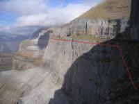
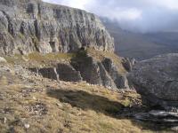
QUOTE (diane @ Sep 25 2006, 01:35 PM)  I think we can forget about RATting any cliffs. Diane, Not at all, not all all! I've got another exemple. You know I'm not a geologist but I've got some experience hiking the mountains and I want to share this one. My wildess dream will be to actualy Rat the cliffs and I believe it IS possible because I hope we can get to the "horizontal feature". Let me show you what I mean. This horizontal feature is still very far and I guess it could look a little bit like this (I'm talking of the upper part since we know that the lower is different from this) :
Pretty steep eh? Now, look how it looks like when you're actualy there :
Convinced ? I'll dedicate my time looking pictures to find out a place where Oppy will have a chance to get there. That's the big difference as compared to Endurance. The feature could be a kind of terrace. They call this "Faja" in Spain. These pictures come (once again) from el "Parque National de Ordessa y del Monte Perdido" and it's called "Faja de las Flores". What about 2007 UMSF meeting there?
-------------------- |
||
|
|
|
||
 dvandorn Victoria's Innards Sep 25 2006, 04:41 AM
 Pando Cough.. cough...
I have to admit though, the ... Sep 25 2006, 05:22 AM
Pando Cough.. cough...
I have to admit though, the ... Sep 25 2006, 05:22 AM
 djellison QUOTE (Pando @ Sep 25 2006, 06:22 AM) I h... Sep 25 2006, 06:48 AM Pando Heh, I know the MC forum had a few people feverish... Sep 25 2006, 07:01 AM djellison http://www.habitablezone.com/space/messages/439873... Sep 25 2006, 07:05 AM edstrick Actually, the graphic will not be that far from re... Sep 25 2006, 09:33 AM Bill Harris Pando's visualization is very close to what we... Sep 25 2006, 10:19 AM Pando QUOTE (Bill Harris @ Sep 25 2006, 03:19 A... Sep 26 2006, 07:25 AM climber I don't fully agree. I also think that Pando... Sep 25 2006, 11:15 AM imipak QUOTE (climber @ Sep 25 2006, 05:19 PM) W... Sep 25 2006, 08:23 PM climber QUOTE (imipak @ Sep 25 2006, 10:23 PM) Si... Sep 25 2006, 08:26 PM diane QUOTE (climber @ Sep 25 2006, 12:19 PM) D... Sep 26 2006, 12:10 AM antoniseb QUOTE (dvandorn @ Sep 24 2006, 10:41 PM) ... Sep 25 2006, 12:33 PM Gray dvandorn asked for wild speculations. I thought I... Sep 25 2006, 01:28 PM ngunn I think we will see evidence of vertical shearing ... Sep 25 2006, 02:05 PM Bill Harris One of the puzzles to me is the scalloped rim of V... Sep 25 2006, 02:26 PM ngunn QUOTE (Bill Harris @ Sep 25 2006, 03:26 P... Sep 25 2006, 02:42 PM BrianL QUOTE (Bill Harris @ Sep 25 2006, 09:26 A... Sep 25 2006, 05:26 PM Jeff7 QUOTE (BrianL @ Sep 25 2006, 01:26 PM) Pr... Sep 26 2006, 12:33 AM fredk QUOTE (Bill Harris @ Sep 25 2006, 02:26 P... Sep 25 2006, 10:55 PM Pando QUOTE (fredk @ Sep 25 2006, 03:55 PM) I w... Sep 26 2006, 02:34 AM ngunn QUOTE (Pando @ Sep 26 2006, 03:34 AM) Hmm... Sep 26 2006, 09:43 AM nprev Kind of bummed about the extensive dust obscuratio... Sep 25 2006, 02:50 PM Nix Now that's the kind of meeting I've been t... Sep 25 2006, 04:52 PM Pando QUOTE (Nix @ Sep 25 2006, 09:52 AM) gathe... Sep 25 2006, 05:11 PM climber QUOTE (Pando @ Sep 25 2006, 07:11 PM) Uh,... Sep 25 2006, 05:31 PM Nix QUOTE (Pando @ Sep 25 2006, 07:11 PM) Uh,... Sep 25 2006, 07:45 PM ngunn Can we please have the barbecue at a safer spot? Sep 25 2006, 08:44 PM Bill Harris QUOTE you have an entire planet to explore and you... Sep 25 2006, 08:44 PM fredk As far as what the interior of Victoria will look ... Sep 25 2006, 11:32 PM Bobby I would say Mud Flap Gal & Mysetery Man will b... Sep 26 2006, 12:39 AM Bill Harris > won't dare step into a geologist's bo... Sep 26 2006, 02:32 AM fredk Thanks, Pando. Judging from the filename and crea... Sep 26 2006, 03:38 AM Bill Harris Uh, yes, your post "over there" a couple... Sep 26 2006, 09:17 AM edstrick Than's for re-posting a pic of the double laye... Sep 26 2006, 10:05 AM ngunn QUOTE (edstrick @ Sep 26 2006, 11:05 AM) ... Sep 26 2006, 11:12 AM edstrick I think most of the local soft-stuff has blown awa... Sep 26 2006, 11:34 AM Gray The latest images of Victoria appear to show that ... Sep 26 2006, 01:50 PM ngunn QUOTE (Gray @ Sep 26 2006, 02:50 PM) The ... Sep 26 2006, 04:47 PM gregp1962 I'm confused. Are we looking over the near rim... Sep 26 2006, 04:53 PM djellison You have it right. I know it's confusing, but... Sep 26 2006, 06:30 PM Pando Dogu? Sep 26 2006, 08:12 PM MarkL Has anyone considered the possibility that Victori... Sep 27 2006, 03:23 AM Pavel QUOTE (MarkL @ Sep 26 2006, 11:23 PM) Has... Sep 27 2006, 05:40 AM Bill Harris >explain its morphology
It's a crater.
--... Sep 27 2006, 07:44 AM MarkL QUOTE (Bill Harris @ Sep 27 2006, 07:44 A... Sep 28 2006, 01:02 AM diane Bill, thanks for posting the Meteor crater formati... Sep 28 2006, 11:51 AM alan Boundary between original surface and ejacta blank... Sep 28 2006, 03:14 PM Gray QUOTE (alan @ Sep 28 2006, 03:14 PM) Boun... Sep 29 2006, 01:39 PM Bill Harris Alan, I've not got this one figured out either... Sep 28 2006, 09:07 PM Burmese Perhaps the layer just below the fine surface coat... Sep 29 2006, 04:26 PM
djellison QUOTE (Pando @ Sep 25 2006, 06:22 AM) I h... Sep 25 2006, 06:48 AM Pando Heh, I know the MC forum had a few people feverish... Sep 25 2006, 07:01 AM djellison http://www.habitablezone.com/space/messages/439873... Sep 25 2006, 07:05 AM edstrick Actually, the graphic will not be that far from re... Sep 25 2006, 09:33 AM Bill Harris Pando's visualization is very close to what we... Sep 25 2006, 10:19 AM Pando QUOTE (Bill Harris @ Sep 25 2006, 03:19 A... Sep 26 2006, 07:25 AM climber I don't fully agree. I also think that Pando... Sep 25 2006, 11:15 AM imipak QUOTE (climber @ Sep 25 2006, 05:19 PM) W... Sep 25 2006, 08:23 PM climber QUOTE (imipak @ Sep 25 2006, 10:23 PM) Si... Sep 25 2006, 08:26 PM diane QUOTE (climber @ Sep 25 2006, 12:19 PM) D... Sep 26 2006, 12:10 AM antoniseb QUOTE (dvandorn @ Sep 24 2006, 10:41 PM) ... Sep 25 2006, 12:33 PM Gray dvandorn asked for wild speculations. I thought I... Sep 25 2006, 01:28 PM ngunn I think we will see evidence of vertical shearing ... Sep 25 2006, 02:05 PM Bill Harris One of the puzzles to me is the scalloped rim of V... Sep 25 2006, 02:26 PM ngunn QUOTE (Bill Harris @ Sep 25 2006, 03:26 P... Sep 25 2006, 02:42 PM BrianL QUOTE (Bill Harris @ Sep 25 2006, 09:26 A... Sep 25 2006, 05:26 PM Jeff7 QUOTE (BrianL @ Sep 25 2006, 01:26 PM) Pr... Sep 26 2006, 12:33 AM fredk QUOTE (Bill Harris @ Sep 25 2006, 02:26 P... Sep 25 2006, 10:55 PM Pando QUOTE (fredk @ Sep 25 2006, 03:55 PM) I w... Sep 26 2006, 02:34 AM ngunn QUOTE (Pando @ Sep 26 2006, 03:34 AM) Hmm... Sep 26 2006, 09:43 AM nprev Kind of bummed about the extensive dust obscuratio... Sep 25 2006, 02:50 PM Nix Now that's the kind of meeting I've been t... Sep 25 2006, 04:52 PM Pando QUOTE (Nix @ Sep 25 2006, 09:52 AM) gathe... Sep 25 2006, 05:11 PM climber QUOTE (Pando @ Sep 25 2006, 07:11 PM) Uh,... Sep 25 2006, 05:31 PM Nix QUOTE (Pando @ Sep 25 2006, 07:11 PM) Uh,... Sep 25 2006, 07:45 PM ngunn Can we please have the barbecue at a safer spot? Sep 25 2006, 08:44 PM Bill Harris QUOTE you have an entire planet to explore and you... Sep 25 2006, 08:44 PM fredk As far as what the interior of Victoria will look ... Sep 25 2006, 11:32 PM Bobby I would say Mud Flap Gal & Mysetery Man will b... Sep 26 2006, 12:39 AM Bill Harris > won't dare step into a geologist's bo... Sep 26 2006, 02:32 AM fredk Thanks, Pando. Judging from the filename and crea... Sep 26 2006, 03:38 AM Bill Harris Uh, yes, your post "over there" a couple... Sep 26 2006, 09:17 AM edstrick Than's for re-posting a pic of the double laye... Sep 26 2006, 10:05 AM ngunn QUOTE (edstrick @ Sep 26 2006, 11:05 AM) ... Sep 26 2006, 11:12 AM edstrick I think most of the local soft-stuff has blown awa... Sep 26 2006, 11:34 AM Gray The latest images of Victoria appear to show that ... Sep 26 2006, 01:50 PM ngunn QUOTE (Gray @ Sep 26 2006, 02:50 PM) The ... Sep 26 2006, 04:47 PM gregp1962 I'm confused. Are we looking over the near rim... Sep 26 2006, 04:53 PM djellison You have it right. I know it's confusing, but... Sep 26 2006, 06:30 PM Pando Dogu? Sep 26 2006, 08:12 PM MarkL Has anyone considered the possibility that Victori... Sep 27 2006, 03:23 AM Pavel QUOTE (MarkL @ Sep 26 2006, 11:23 PM) Has... Sep 27 2006, 05:40 AM Bill Harris >explain its morphology
It's a crater.
--... Sep 27 2006, 07:44 AM MarkL QUOTE (Bill Harris @ Sep 27 2006, 07:44 A... Sep 28 2006, 01:02 AM diane Bill, thanks for posting the Meteor crater formati... Sep 28 2006, 11:51 AM alan Boundary between original surface and ejacta blank... Sep 28 2006, 03:14 PM Gray QUOTE (alan @ Sep 28 2006, 03:14 PM) Boun... Sep 29 2006, 01:39 PM Bill Harris Alan, I've not got this one figured out either... Sep 28 2006, 09:07 PM Burmese Perhaps the layer just below the fine surface coat... Sep 29 2006, 04:26 PM |

|
Lo-Fi Version | Time is now: 27th September 2024 - 07:22 AM |
|
RULES AND GUIDELINES Please read the Forum Rules and Guidelines before posting. IMAGE COPYRIGHT |
OPINIONS AND MODERATION Opinions expressed on UnmannedSpaceflight.com are those of the individual posters and do not necessarily reflect the opinions of UnmannedSpaceflight.com or The Planetary Society. The all-volunteer UnmannedSpaceflight.com moderation team is wholly independent of The Planetary Society. The Planetary Society has no influence over decisions made by the UnmannedSpaceflight.com moderators. |
SUPPORT THE FORUM Unmannedspaceflight.com is funded by the Planetary Society. Please consider supporting our work and many other projects by donating to the Society or becoming a member. |
|