Getting to 'Big Crater', A little premature speculation |

Getting to 'Big Crater', A little premature speculation |
 Sep 21 2006, 11:57 AM Sep 21 2006, 11:57 AM
Post
#1
|
|
 Member  Group: Members Posts: 813 Joined: 8-February 04 From: Arabia Terra Member No.: 12 |
Opportunity is not quite at Victoria yet, but on the horizon is a tantalising goal for the future- the big eroded crater to the south-east, the rim of which is already visible. This is the first 'large scale' topography of the mission so far. Wouldn't it be great if Opportunity could get to these hills and uncover their secrets?
http://homepage.ntlworld.com/sfjcody2/route_to_big.jpg |
 |
 
|
 |
|
Sep 25 2006, 10:14 PM
Post
#2
|
||
|
Member Group: Members Posts: 111 Joined: 14-March 05 From: Vastitas Borealis Member No.: 193 |
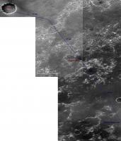
On the excuse that the subtitle of this thread is 'premature speculation' I dare to present a premature routemap for the MER drivers. I went to the MOC gallery and found two narrow angle images adjacent to and east of S0500863, which cover the most part of the area between Victoria and the Big Crater (or Ithaca, as suggested):
http://www.msss.com/moc_gallery/e19_r02/im...3/E2301344.html http://www.msss.com/moc_gallery/e01_e06/im...5/E0502642.html To build this map I stitched the non-map-projected jpegs that are a bit 'flattened' but just therefore quite suitable for this purpose (though I had to hammer Victoria a bit flatter also). Below only the southern part shrunk to 60%, but it's still large (~1 Mb). I think I found a relatively dune-free path for Oppy, so if she were driving say 200 m every other sol, she could reach 'Ithaca' around the Christmas 2007, after completing studies in Victoria next September. 
Attached thumbnail(s)
|
|
|
|
|
|
|
Sep 26 2006, 04:06 PM
Post
#3
|
||
 Member Group: Members Posts: 656 Joined: 20-April 05 From: League City, Texas Member No.: 285 |
QUOTE (marswiggle @ Sep 25 2006, 05:14 PM)  On the excuse that the subtitle of this thread is 'premature speculation' I dare to present a premature routemap ... In a broader sense, saving the hill climbing for late in the process to preserve rover health and maximize science opportunities, I would envision something like this:
This doesn't account for the dune orientation, which would undoubtedly lead to a lot of fine adjustments. |
|
|
|
|
|
|
Sep 26 2006, 04:18 PM
Post
#4
|
|
|
Senior Member Group: Members Posts: 2922 Joined: 14-February 06 From: Very close to the Pyrénées Mountains (France) Member No.: 682 |
QUOTE (algorimancer @ Sep 26 2006, 06:06 PM) In a broader sense, saving the hill climbing for late in the process to preserve rover health and maximize science opportunities, I would envision something like this: This doesn't account for the dune orientation, which would undoubtedly lead to a lot of fine adjustments. It makes sense. Since the begining of Oppy's journey we're going down and down so, it'll be very important to explore features above what we've seen so far. But, what I can't believe is that you've got project AFTER big crater. Good on you. 
-------------------- |
|
|
|
 SFJCody Getting to 'Big Crater' Sep 21 2006, 11:57 AM
 Castor I agree that exploring the West Rim of Big Crater ... Sep 21 2006, 12:04 PM Bill Harris Actually, the "Leg B of the etched terrain... Sep 21 2006, 12:14 PM
 ustrax And I was hesitating on starting talking about thi... Sep 21 2006, 12:40 PM Jeff7 QUOTE (ustrax @ Sep 21 2006, 08:40 AM) An... Sep 21 2006, 09:30 PM climber QUOTE (Jeff7 @ Sep 21 2006, 11:30 PM) Tim... Sep 21 2006, 09:49 PM algorimancer QUOTE (SFJCody @ Sep 21 2006, 06:57 AM) .... Sep 21 2006, 12:52 PM SFJCody QUOTE (algorimancer @ Sep 21 2006, 01:52 ... Sep 21 2006, 01:19 PM slinted QUOTE (SFJCody @ Sep 21 2006, 06:19 AM) I... Sep 21 2006, 09:35 PM climber QUOTE (slinted @ Sep 21 2006, 11:35 PM) Y... Sep 21 2006, 09:57 PM djellison QUOTE (climber @ Sep 21 2006, 10:57 PM) w... Sep 21 2006, 10:13 PM djellison For the love of god don't let a rover driver s... Sep 21 2006, 12:58 PM ustrax QUOTE (djellison @ Sep 21 2006, 01:58 PM)... Sep 21 2006, 01:09 PM climber QUOTE (ustrax @ Sep 21 2006, 03:09 PM) Te... Sep 21 2006, 03:33 PM mhoward QUOTE (ustrax @ Sep 21 2006, 01:09 PM) ht... Sep 21 2006, 03:56 PM jamescanvin QUOTE (ustrax @ Sep 21 2006, 11:09 PM) Te... Sep 21 2006, 11:33 PM MahFL Can anyone tell if the rim is higher than the Colu... Sep 21 2006, 11:59 PM clt510 QUOTE (jamescanvin @ Sep 21 2006, 06:33 P... Sep 22 2006, 04:55 AM ustrax QUOTE (jamescanvin @ Sep 22 2006, 12:33 A... Sep 22 2006, 09:02 AM Stephen QUOTE (ustrax @ Sep 22 2006, 09:02 AM) I ... Sep 22 2006, 10:42 AM ustrax QUOTE (Stephen @ Sep 22 2006, 11:42 AM) T... Sep 22 2006, 11:13 AM climber QUOTE (ustrax @ Sep 22 2006, 01:13 PM) (U... Sep 22 2006, 11:32 AM Nix That horizon looks like the one I posted in the mo... Sep 21 2006, 01:25 PM ustrax QUOTE (Nix @ Sep 21 2006, 02:25 PM) That ... Sep 21 2006, 01:42 PM tim53 QUOTE (SFJCody @ Sep 21 2006, 04:57 AM) O... Sep 21 2006, 04:34 PM ustrax So...Victoria shouldn't bear a city's name... Sep 21 2006, 04:39 PM tim53 QUOTE (ustrax @ Sep 21 2006, 09:39 AM)
... Sep 21 2006, 08:47 PM climber QUOTE (tim53 @ Sep 21 2006, 06:34 PM) It ... Sep 21 2006, 04:40 PM ustrax QUOTE (climber @ Sep 21 2006, 05:40 PM) S... Sep 21 2006, 04:45 PM ElkGroveDan QUOTE (tim53 @ Sep 21 2006, 08:34 AM) the... Sep 21 2006, 05:51 PM odave QUOTE (tim53 @ Sep 21 2006, 12:34 PM) ...... Sep 22 2006, 12:35 PM ustrax QUOTE (odave @ Sep 22 2006, 01:35 PM) Dar... Sep 22 2006, 02:39 PM Pavel QUOTE (ustrax @ Sep 22 2006, 10:39 AM) ... Sep 22 2006, 03:22 PM ustrax QUOTE (ustrax @ Sep 22 2006, 03:39 PM) It... Sep 22 2006, 03:24 PM Marz QUOTE (ustrax @ Sep 22 2006, 10:24 AM) Dr... Sep 22 2006, 04:08 PM ustrax QUOTE (Marz @ Sep 22 2006, 05:08 PM) Wow,... Sep 22 2006, 04:17 PM tim53 QUOTE (Marz @ Sep 22 2006, 09:08 AM) Wow,... Sep 22 2006, 05:15 PM ustrax QUOTE (tim53 @ Sep 22 2006, 06:15 PM) Um.... Sep 22 2006, 05:52 PM tim53 QUOTE (ustrax @ Sep 22 2006, 10:52 AM) On... Sep 22 2006, 06:23 PM climber QUOTE (tim53 @ Sep 22 2006, 08:23 PM) Yea... Sep 22 2006, 10:33 PM jamescanvin QUOTE (climber @ Sep 23 2006, 08:33 AM) H... Sep 22 2006, 10:58 PM Pando QUOTE (climber @ Sep 22 2006, 03:33 PM) G... Sep 22 2006, 11:25 PM ustrax QUOTE (tim53 @ Sep 22 2006, 07:23 PM) Yea... Sep 25 2006, 12:43 PM Pavel QUOTE (ustrax @ Sep 22 2006, 11:24 AM) ED... Sep 22 2006, 05:43 PM Astrophil Lovely Cavafy poem. Let me throw in Tennyson... Sep 23 2006, 07:55 PM Ant103 This thread remember me an other thread I made a t... Sep 21 2006, 04:45 PM imipak Mad, mad, mad... you're all completely mad. I ... Sep 21 2006, 08:12 PM jamescanvin If you look at the image I posted back here - http... Sep 22 2006, 12:29 AM djellison Oh we've got to stop this I'm getting e... Sep 22 2006, 07:02 AM Stephen QUOTE (djellison @ Sep 22 2006, 07:02 AM)... Sep 22 2006, 08:45 AM djellison QUOTE (Stephen @ Sep 22 2006, 09:45 AM) O... Sep 22 2006, 08:49 AM Stephen QUOTE (djellison @ Sep 22 2006, 08:49 AM)... Sep 22 2006, 10:29 AM ustrax QUOTE (Stephen @ Sep 22 2006, 11:29 AM) I... Sep 22 2006, 10:39 AM ElkGroveDan QUOTE (Stephen @ Sep 22 2006, 02:29 AM) I... Sep 22 2006, 03:00 PM 1101001 QUOTE (ElkGroveDan @ Sep 22 2006, 08:00 A... Sep 23 2006, 01:25 AM MahFL I saw the movies, and some where the rover would h... Sep 23 2006, 02:56 PM Nix Me n'either, it's just too far. I might be... Sep 22 2006, 07:17 AM SFJCody I don't really believe it either, but if Oppor... Sep 22 2006, 07:37 AM ugordan QUOTE (SFJCody @ Sep 22 2006, 08:37 AM) .... Sep 22 2006, 07:56 AM climber QUOTE (ugordan @ Sep 22 2006, 09:56 AM) T... Sep 22 2006, 08:14 AM ugordan QUOTE (climber @ Sep 22 2006, 09:14 AM) O... Sep 22 2006, 08:31 AM SFJCody One more reason to be interested in going to this ... Sep 22 2006, 08:42 AM Phil Stooke SFJCody said "One more reason to be intereste... Sep 22 2006, 12:36 PM SFJCody QUOTE (Phil Stooke @ Sep 22 2006, 01:36 P... Sep 22 2006, 12:58 PM ugordan I'm with Phil on the data gap thought. While t... Sep 22 2006, 01:18 PM SFJCody QUOTE (ugordan @ Sep 22 2006, 02:18 PM) I... Sep 22 2006, 01:27 PM climber QUOTE (SFJCody @ Sep 22 2006, 02:58 PM) T... Sep 22 2006, 01:22 PM Bobby Now what are the overall odds of Oppy Getting to T... Sep 23 2006, 01:18 AM Oren Iishi QUOTE (Bobby @ Sep 23 2006, 01:18 AM) Now... Sep 23 2006, 02:19 PM climber QUOTE (Oren Iishi @ Sep 23 2006, 04:19 PM... Sep 23 2006, 02:26 PM MahFL I don't think its just driving s/w I think its... Sep 23 2006, 02:58 PM algorimancer Just to put everthing in a wider context, I have a... Sep 23 2006, 06:28 PM algorimancer I found an MOC image that goes right through the m... Sep 23 2006, 08:27 PM tim53 QUOTE (algorimancer @ Sep 23 2006, 01:27 ... Sep 24 2006, 03:53 AM SFJCody I think the trickiest issue for the planners would... Sep 24 2006, 11:33 AM BrianL QUOTE (SFJCody @ Sep 24 2006, 06:33 AM) I... Sep 24 2006, 02:45 PM Nix Thanks for the search algorimancer..been wondering... Sep 23 2006, 08:56 PM stevesliva QUOTE (Nix @ Sep 23 2006, 04:56 PM) -the ... Sep 23 2006, 09:05 PM algorimancer QUOTE (Nix @ Sep 23 2006, 03:56 PM) -the ... Sep 26 2006, 11:36 PM Nix Those would be mighty big sandworms
Nico Sep 23 2006, 09:07 PM algorimancer Does anyone know what minerals are being highlight... Sep 23 2006, 10:19 PM algorimancer QUOTE (climber @ Sep 26 2006, 11:18 AM) B... Sep 26 2006, 05:17 PM stevelu QUOTE (algorimancer @ Sep 26 2006, 10:17 ... Sep 26 2006, 06:27 PM djellison QUOTE (algorimancer @ Sep 26 2006, 06:17 ... Sep 26 2006, 06:33 PM Bobby Stay Tuned for upcoming event's.
Beacon 2 Pol... Sep 26 2006, 12:29 AM algorimancer Just at the moment I'm a bit conflicted as to ... Sep 26 2006, 12:47 PM Phil Stooke marswiggle's mosaic is nice. I'd never lo... Sep 26 2006, 03:09 PM JRehling QUOTE (Phil Stooke @ Sep 26 2006, 08:09 A... Sep 26 2006, 06:45 PM antoniseb QUOTE (JRehling @ Sep 26 2006, 12:45 PM) ... Sep 26 2006, 06:54 PM imipak QUOTE (antoniseb @ Sep 26 2006, 07:54 PM)... Sep 26 2006, 07:11 PM climber QUOTE (imipak @ Sep 26 2006, 09:11 PM) A ... Sep 26 2006, 07:25 PM Bart QUOTE (antoniseb @ Sep 26 2006, 11:54 AM)... Sep 26 2006, 09:40 PM odave ...or piggyback a couple of these little guys Sep 26 2006, 07:00 PM ilbasso Maybe we'll learn that the rovers have little ... Sep 26 2006, 09:56 PM jamescanvin Notice in todays JPL update they agree that the ma... Sep 26 2006, 10:41 PM MaxSt I don't get it... On which rim of Big Crater a... Sep 27 2006, 06:08 AM jamescanvin The twin peaks are on the north rim of the big cra... Sep 27 2006, 06:23 AM
ustrax And I was hesitating on starting talking about thi... Sep 21 2006, 12:40 PM Jeff7 QUOTE (ustrax @ Sep 21 2006, 08:40 AM) An... Sep 21 2006, 09:30 PM climber QUOTE (Jeff7 @ Sep 21 2006, 11:30 PM) Tim... Sep 21 2006, 09:49 PM algorimancer QUOTE (SFJCody @ Sep 21 2006, 06:57 AM) .... Sep 21 2006, 12:52 PM SFJCody QUOTE (algorimancer @ Sep 21 2006, 01:52 ... Sep 21 2006, 01:19 PM slinted QUOTE (SFJCody @ Sep 21 2006, 06:19 AM) I... Sep 21 2006, 09:35 PM climber QUOTE (slinted @ Sep 21 2006, 11:35 PM) Y... Sep 21 2006, 09:57 PM djellison QUOTE (climber @ Sep 21 2006, 10:57 PM) w... Sep 21 2006, 10:13 PM djellison For the love of god don't let a rover driver s... Sep 21 2006, 12:58 PM ustrax QUOTE (djellison @ Sep 21 2006, 01:58 PM)... Sep 21 2006, 01:09 PM climber QUOTE (ustrax @ Sep 21 2006, 03:09 PM) Te... Sep 21 2006, 03:33 PM mhoward QUOTE (ustrax @ Sep 21 2006, 01:09 PM) ht... Sep 21 2006, 03:56 PM jamescanvin QUOTE (ustrax @ Sep 21 2006, 11:09 PM) Te... Sep 21 2006, 11:33 PM MahFL Can anyone tell if the rim is higher than the Colu... Sep 21 2006, 11:59 PM clt510 QUOTE (jamescanvin @ Sep 21 2006, 06:33 P... Sep 22 2006, 04:55 AM ustrax QUOTE (jamescanvin @ Sep 22 2006, 12:33 A... Sep 22 2006, 09:02 AM Stephen QUOTE (ustrax @ Sep 22 2006, 09:02 AM) I ... Sep 22 2006, 10:42 AM ustrax QUOTE (Stephen @ Sep 22 2006, 11:42 AM) T... Sep 22 2006, 11:13 AM climber QUOTE (ustrax @ Sep 22 2006, 01:13 PM) (U... Sep 22 2006, 11:32 AM Nix That horizon looks like the one I posted in the mo... Sep 21 2006, 01:25 PM ustrax QUOTE (Nix @ Sep 21 2006, 02:25 PM) That ... Sep 21 2006, 01:42 PM tim53 QUOTE (SFJCody @ Sep 21 2006, 04:57 AM) O... Sep 21 2006, 04:34 PM ustrax So...Victoria shouldn't bear a city's name... Sep 21 2006, 04:39 PM tim53 QUOTE (ustrax @ Sep 21 2006, 09:39 AM)
... Sep 21 2006, 08:47 PM climber QUOTE (tim53 @ Sep 21 2006, 06:34 PM) It ... Sep 21 2006, 04:40 PM ustrax QUOTE (climber @ Sep 21 2006, 05:40 PM) S... Sep 21 2006, 04:45 PM ElkGroveDan QUOTE (tim53 @ Sep 21 2006, 08:34 AM) the... Sep 21 2006, 05:51 PM odave QUOTE (tim53 @ Sep 21 2006, 12:34 PM) ...... Sep 22 2006, 12:35 PM ustrax QUOTE (odave @ Sep 22 2006, 01:35 PM) Dar... Sep 22 2006, 02:39 PM Pavel QUOTE (ustrax @ Sep 22 2006, 10:39 AM) ... Sep 22 2006, 03:22 PM ustrax QUOTE (ustrax @ Sep 22 2006, 03:39 PM) It... Sep 22 2006, 03:24 PM Marz QUOTE (ustrax @ Sep 22 2006, 10:24 AM) Dr... Sep 22 2006, 04:08 PM ustrax QUOTE (Marz @ Sep 22 2006, 05:08 PM) Wow,... Sep 22 2006, 04:17 PM tim53 QUOTE (Marz @ Sep 22 2006, 09:08 AM) Wow,... Sep 22 2006, 05:15 PM ustrax QUOTE (tim53 @ Sep 22 2006, 06:15 PM) Um.... Sep 22 2006, 05:52 PM tim53 QUOTE (ustrax @ Sep 22 2006, 10:52 AM) On... Sep 22 2006, 06:23 PM climber QUOTE (tim53 @ Sep 22 2006, 08:23 PM) Yea... Sep 22 2006, 10:33 PM jamescanvin QUOTE (climber @ Sep 23 2006, 08:33 AM) H... Sep 22 2006, 10:58 PM Pando QUOTE (climber @ Sep 22 2006, 03:33 PM) G... Sep 22 2006, 11:25 PM ustrax QUOTE (tim53 @ Sep 22 2006, 07:23 PM) Yea... Sep 25 2006, 12:43 PM Pavel QUOTE (ustrax @ Sep 22 2006, 11:24 AM) ED... Sep 22 2006, 05:43 PM Astrophil Lovely Cavafy poem. Let me throw in Tennyson... Sep 23 2006, 07:55 PM Ant103 This thread remember me an other thread I made a t... Sep 21 2006, 04:45 PM imipak Mad, mad, mad... you're all completely mad. I ... Sep 21 2006, 08:12 PM jamescanvin If you look at the image I posted back here - http... Sep 22 2006, 12:29 AM djellison Oh we've got to stop this I'm getting e... Sep 22 2006, 07:02 AM Stephen QUOTE (djellison @ Sep 22 2006, 07:02 AM)... Sep 22 2006, 08:45 AM djellison QUOTE (Stephen @ Sep 22 2006, 09:45 AM) O... Sep 22 2006, 08:49 AM Stephen QUOTE (djellison @ Sep 22 2006, 08:49 AM)... Sep 22 2006, 10:29 AM ustrax QUOTE (Stephen @ Sep 22 2006, 11:29 AM) I... Sep 22 2006, 10:39 AM ElkGroveDan QUOTE (Stephen @ Sep 22 2006, 02:29 AM) I... Sep 22 2006, 03:00 PM 1101001 QUOTE (ElkGroveDan @ Sep 22 2006, 08:00 A... Sep 23 2006, 01:25 AM MahFL I saw the movies, and some where the rover would h... Sep 23 2006, 02:56 PM Nix Me n'either, it's just too far. I might be... Sep 22 2006, 07:17 AM SFJCody I don't really believe it either, but if Oppor... Sep 22 2006, 07:37 AM ugordan QUOTE (SFJCody @ Sep 22 2006, 08:37 AM) .... Sep 22 2006, 07:56 AM climber QUOTE (ugordan @ Sep 22 2006, 09:56 AM) T... Sep 22 2006, 08:14 AM ugordan QUOTE (climber @ Sep 22 2006, 09:14 AM) O... Sep 22 2006, 08:31 AM SFJCody One more reason to be interested in going to this ... Sep 22 2006, 08:42 AM Phil Stooke SFJCody said "One more reason to be intereste... Sep 22 2006, 12:36 PM SFJCody QUOTE (Phil Stooke @ Sep 22 2006, 01:36 P... Sep 22 2006, 12:58 PM ugordan I'm with Phil on the data gap thought. While t... Sep 22 2006, 01:18 PM SFJCody QUOTE (ugordan @ Sep 22 2006, 02:18 PM) I... Sep 22 2006, 01:27 PM climber QUOTE (SFJCody @ Sep 22 2006, 02:58 PM) T... Sep 22 2006, 01:22 PM Bobby Now what are the overall odds of Oppy Getting to T... Sep 23 2006, 01:18 AM Oren Iishi QUOTE (Bobby @ Sep 23 2006, 01:18 AM) Now... Sep 23 2006, 02:19 PM climber QUOTE (Oren Iishi @ Sep 23 2006, 04:19 PM... Sep 23 2006, 02:26 PM MahFL I don't think its just driving s/w I think its... Sep 23 2006, 02:58 PM algorimancer Just to put everthing in a wider context, I have a... Sep 23 2006, 06:28 PM algorimancer I found an MOC image that goes right through the m... Sep 23 2006, 08:27 PM tim53 QUOTE (algorimancer @ Sep 23 2006, 01:27 ... Sep 24 2006, 03:53 AM SFJCody I think the trickiest issue for the planners would... Sep 24 2006, 11:33 AM BrianL QUOTE (SFJCody @ Sep 24 2006, 06:33 AM) I... Sep 24 2006, 02:45 PM Nix Thanks for the search algorimancer..been wondering... Sep 23 2006, 08:56 PM stevesliva QUOTE (Nix @ Sep 23 2006, 04:56 PM) -the ... Sep 23 2006, 09:05 PM algorimancer QUOTE (Nix @ Sep 23 2006, 03:56 PM) -the ... Sep 26 2006, 11:36 PM Nix Those would be mighty big sandworms
Nico Sep 23 2006, 09:07 PM algorimancer Does anyone know what minerals are being highlight... Sep 23 2006, 10:19 PM algorimancer QUOTE (climber @ Sep 26 2006, 11:18 AM) B... Sep 26 2006, 05:17 PM stevelu QUOTE (algorimancer @ Sep 26 2006, 10:17 ... Sep 26 2006, 06:27 PM djellison QUOTE (algorimancer @ Sep 26 2006, 06:17 ... Sep 26 2006, 06:33 PM Bobby Stay Tuned for upcoming event's.
Beacon 2 Pol... Sep 26 2006, 12:29 AM algorimancer Just at the moment I'm a bit conflicted as to ... Sep 26 2006, 12:47 PM Phil Stooke marswiggle's mosaic is nice. I'd never lo... Sep 26 2006, 03:09 PM JRehling QUOTE (Phil Stooke @ Sep 26 2006, 08:09 A... Sep 26 2006, 06:45 PM antoniseb QUOTE (JRehling @ Sep 26 2006, 12:45 PM) ... Sep 26 2006, 06:54 PM imipak QUOTE (antoniseb @ Sep 26 2006, 07:54 PM)... Sep 26 2006, 07:11 PM climber QUOTE (imipak @ Sep 26 2006, 09:11 PM) A ... Sep 26 2006, 07:25 PM Bart QUOTE (antoniseb @ Sep 26 2006, 11:54 AM)... Sep 26 2006, 09:40 PM odave ...or piggyback a couple of these little guys Sep 26 2006, 07:00 PM ilbasso Maybe we'll learn that the rovers have little ... Sep 26 2006, 09:56 PM jamescanvin Notice in todays JPL update they agree that the ma... Sep 26 2006, 10:41 PM MaxSt I don't get it... On which rim of Big Crater a... Sep 27 2006, 06:08 AM jamescanvin The twin peaks are on the north rim of the big cra... Sep 27 2006, 06:23 AM |

|
Lo-Fi Version | Time is now: 23rd September 2024 - 11:19 PM |
|
RULES AND GUIDELINES Please read the Forum Rules and Guidelines before posting. IMAGE COPYRIGHT |
OPINIONS AND MODERATION Opinions expressed on UnmannedSpaceflight.com are those of the individual posters and do not necessarily reflect the opinions of UnmannedSpaceflight.com or The Planetary Society. The all-volunteer UnmannedSpaceflight.com moderation team is wholly independent of The Planetary Society. The Planetary Society has no influence over decisions made by the UnmannedSpaceflight.com moderators. |
SUPPORT THE FORUM Unmannedspaceflight.com is funded by the Planetary Society. Please consider supporting our work and many other projects by donating to the Society or becoming a member. |
|