Duck Bay, Victoria arrival point |

Duck Bay, Victoria arrival point |
 Sep 28 2006, 03:15 PM Sep 28 2006, 03:15 PM
Post
#1
|
|||||
|
Founder  Group: Chairman Posts: 14433 Joined: 8-February 04 Member No.: 1 |
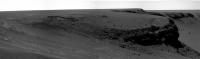
Now yes - while it's fair to say we have arrived at the rim of Vic - the rule were that the 'arrival' date would be the sol at which the rover arrives at the point from which the mother-of-all-pans is taken... so we're not there yet. (i.e. We'll probably take photos when we arrive in Valencia on Sat PM - but personally, I wont feel I've arrived till the following morning when I have a look out the window....and you're right Fred - it's that FIRST big MOAP that is the important one )
But that doesn't mean we can't have a new thread  Doug
Attached thumbnail(s)
|
||||
 |
 
|
||||
 |
|
Sep 28 2006, 08:23 PM
Post
#2
|
|
 Chief Assistant Group: Admin Posts: 1409 Joined: 5-January 05 From: Ierapetra, Greece Member No.: 136 |
Happy Birthday BrianL
I LOooove these layers, they're everywhere. I feel like a little child in a new sandbox   Nico -------------------- photographer, space imagery enthusiast, proud father and partner, and geek.
http://500px.com/sacred-photons & |
|
|
|
|
Sep 29 2006, 08:36 AM
Post
#3
|
||
|
Junior Member Group: Members Posts: 64 Joined: 24-May 06 From: Aberdeen, Scotland Member No.: 785 |
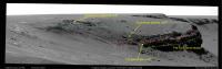
QUOTE (Nix @ Sep 28 2006, 09:23 PM)  I LOooove these layers, they're everywhere. I feel like a little child in a new sandbox Nico Nico, I'm not sure I agree with your layer interpretation, but put 10 geologists in the same sandbox and they'll come up with 10 different interpretations!  I think the layers follow the crater contours rather than bend up towards the edge. I think we can see some of the same layers that we saw at Endurance (I'm afraid I've forgotten the formation names), but it's difficult to make a confident correlation. I think the top is the evaporite, followed by the same aeolian layers that saw at Endurance. There then seems to be a bright conglomeratic layer, which may be the bright layer we can see on the far rim of VC. Below that are layers we haven't seen before, but because they are in shadow it's hard to interpret them from our current location. I'd be interested in the views and comments of my fellow forum geologists.
Thanks for the base image Nico. Castor |
|
|
|
|
|
 djellison Duck Bay Sep 28 2006, 03:15 PM
 Indian3000 quick pano
sol 952 L0
Sep 28 2006, 03:22 PM fredk Beautiful pans, Doug! But I think it should b... Sep 28 2006, 03:26 PM
Indian3000 quick pano
sol 952 L0
Sep 28 2006, 03:22 PM fredk Beautiful pans, Doug! But I think it should b... Sep 28 2006, 03:26 PM
 diane QUOTE (fredk @ Sep 28 2006, 11:26 AM) Bea... Sep 28 2006, 03:50 PM Stu Couldn't resist it... lens flare and all! ... Sep 28 2006, 03:45 PM Pavel QUOTE (Stu @ Sep 28 2006, 11:45 AM) Could... Sep 28 2006, 04:55 PM climber QUOTE (Pavel @ Sep 28 2006, 06:55 PM) Tha... Sep 28 2006, 07:51 PM BrianL Wow and double-clink! What a great birthday pr... Sep 28 2006, 08:05 PM climber QUOTE (BrianL @ Sep 28 2006, 10:05 PM) Wh... Sep 28 2006, 08:18 PM Nirgal QUOTE (climber @ Sep 28 2006, 09:51 PM) O... Sep 28 2006, 09:09 PM Nix QUOTE (Stu @ Sep 28 2006, 05:45 PM) Could... Sep 28 2006, 05:10 PM gregp1962 WOW!!
To me, it totally feels like we... Sep 28 2006, 03:46 PM Rakhir QUOTE (gregp1962 @ Sep 28 2006, 05:46 PM)... Sep 28 2006, 03:54 PM fredk Well, someone's making a fortune off what I... Sep 28 2006, 03:46 PM DDAVIS With todays images, another one occurs to me: We ... Sep 28 2006, 10:55 PM mhoward Wow.
Be sure to click the link to "Origi... Sep 28 2006, 03:48 PM djellison QUOTE (mhoward @ Sep 28 2006, 04:48 PM) a... Sep 28 2006, 03:55 PM Nix Oh man!! These images are freaking me out ... Sep 28 2006, 03:54 PM Bill Harris What wonderful outcrops and active erosional featu... Sep 28 2006, 03:55 PM karl QUOTE (Bill Harris @ Sep 28 2006, 10:55 A... Sep 28 2006, 04:52 PM fredk QUOTE (karl @ Sep 28 2006, 04:52 PM) It i... Sep 28 2006, 05:20 PM Castor From here Cabo Frio looks a doddle and would be my... Sep 28 2006, 03:59 PM Indian3000 vertical projection 1cm/pix
Sep 28 2006, 04:11 PM aldo12xu QUOTE (Indian3000 @ Sep 28 2006, 04:11 PM... Sep 28 2006, 05:51 PM Indian3000 QUOTE (aldo12xu @ Sep 28 2006, 07:51 PM) ... Sep 28 2006, 07:23 PM climber QUOTE (Indian3000 @ Sep 28 2006, 09:23 PM... Sep 28 2006, 08:00 PM jvandriel Here is just a part of the Victoria panorama.
Tak... Sep 28 2006, 04:24 PM Ant103 Let me just finsh to take my eyes and put in their... Sep 28 2006, 04:29 PM jvandriel Here is the other part.
Taken with the L7 pancam... Sep 28 2006, 04:40 PM Nix woaw (again), a first mosaic, I'm actually enj... Sep 28 2006, 04:44 PM WindyT I didn't want to make a whole new thread about... Sep 28 2006, 04:52 PM Stu QUOTE (Pavel @ Sep 28 2006, 04:55 PM) Did... Sep 28 2006, 05:03 PM jvandriel Here is the Navcam panorama of Victoria.
Taken wi... Sep 28 2006, 05:09 PM Nix Cabo Verde...
Nico Sep 28 2006, 05:35 PM jabe QUOTE (Nix @ Sep 28 2006, 05:35 PM)
An y... Sep 28 2006, 05:43 PM Holder of the Two Leashes QUOTE (Nix @ Sep 28 2006, 12:35 PM) Cabo ... Sep 28 2006, 06:58 PM fredk Just to clarify things a bit amidst this mad flurr... Sep 28 2006, 05:40 PM Tman These new stunning pictures from Mars are so stimu... Sep 28 2006, 05:48 PM fredk Lot's of requests for scale info - here's ... Sep 28 2006, 06:16 PM mhoward QUOTE (fredk @ Sep 28 2006, 06:16 PM) Lot... Sep 28 2006, 06:29 PM odave QUOTE (fredk @ Sep 28 2006, 02:16 PM) Lot... Sep 28 2006, 07:49 PM volcanopele That Capo Verde outcrop looks like it would be rea... Sep 28 2006, 06:23 PM Nix Thanks for those measurements fredk, I already had... Sep 28 2006, 06:24 PM algorimancer QUOTE (Nix @ Sep 28 2006, 01:24 PM) Thank... Sep 28 2006, 07:17 PM Tman I'm a bit out of form. Dose ~15 m mean that we... Sep 28 2006, 06:31 PM odave QUOTE (Tman @ Sep 28 2006, 02:31 PM) I... Sep 28 2006, 07:56 PM fredk Tman - I read recently that Endurance gave us abou... Sep 28 2006, 06:41 PM Nix Yes, SPM is great! Do you Auto-align the image... Sep 28 2006, 06:48 PM ngunn A question: Are we sure that the current view show... Sep 28 2006, 07:19 PM fredk QUOTE (ngunn @ Sep 28 2006, 07:19 PM) A q... Sep 28 2006, 09:49 PM ngunn QUOTE (fredk @ Sep 28 2006, 10:49 PM) Yea... Sep 29 2006, 02:19 PM Reckless The rocks may be jumbled but there are layers ever... Sep 28 2006, 07:19 PM Stu Is this kind of right...ish..?
Sep 28 2006, 08:07 PM Tman If Oppy's twin should like just to park on Fri... Sep 28 2006, 08:08 PM Stu QUOTE (Tman @ Sep 28 2006, 08:08 PM) If O... Sep 28 2006, 08:21 PM climber QUOTE (Castor @ Sep 29 2006, 10:36 AM) Th... Sep 29 2006, 09:05 AM Tman QUOTE (Castor @ Sep 29 2006, 10:36 AM) I ... Sep 29 2006, 11:10 AM Gray QUOTE (Castor @ Sep 29 2006, 08:36 AM) I ... Sep 29 2006, 01:23 PM climber Hey Climber,
Would you like to have a go at this? ... Sep 28 2006, 08:31 PM Indian3000 view of Opportunity's postion sol 952 from sol... Sep 28 2006, 09:13 PM jamescanvin 14 pointing colour pancam mosaic of Duck Bay up fo... Sep 28 2006, 09:35 PM tedstryk QUOTE (jamescanvin @ Sep 28 2006, 09:35 P... Sep 29 2006, 12:16 AM alan JPL's image release
http://marsrovers.jpl.nasa... Sep 28 2006, 09:37 PM djellison 14 frames... 7 x 2 perhaps... I would call that pa... Sep 28 2006, 10:06 PM jamescanvin Good call Doug.
Horay we've arrived! .... Sep 28 2006, 10:31 PM Nix Yippieee!! 14 color frames
'extreme... Sep 28 2006, 10:54 PM Holder of the Two Leashes QUOTE (Nix @ Sep 28 2006, 05:54 PM) Yippi... Sep 29 2006, 01:00 AM MarkL QUOTE (Holder of the Two Leashes @ Sep 29 200... Sep 29 2006, 02:27 AM Holder of the Two Leashes QUOTE (MarkL @ Sep 28 2006, 09:27 PM) I c... Sep 29 2006, 02:59 AM hortonheardawho RE: Duck Bay Sep 28 2006, 11:10 PM RedSky QUOTE (hortonheardawho @ Sep 28 2006, 07... Sep 29 2006, 12:24 AM MarkL QUOTE (hortonheardawho @ Sep 28 2006, 11... Sep 29 2006, 02:04 AM Astro0 I know the true-colour images are on their way, bu... Sep 29 2006, 12:07 AM Floyd Mission Update from Steve Squyres
http://athena.co... Sep 29 2006, 01:14 AM fredk Well, now that we've "officially" ar... Sep 29 2006, 04:18 AM ElkGroveDan QUOTE (fredk @ Sep 28 2006, 08:18 PM) Wel... Sep 29 2006, 04:42 AM mhoward QUOTE (fredk @ Sep 29 2006, 04:18 AM) Not... Sep 29 2006, 05:35 AM Tman QUOTE (mhoward @ Sep 29 2006, 07:35 AM) W... Sep 29 2006, 10:18 AM MahFL Oppy is female . Sep 29 2006, 10:38 AM Tman QUOTE (MahFL @ Sep 29 2006, 12:38 PM) Opp... Sep 29 2006, 11:17 AM Shaka QUOTE (fredk @ Sep 28 2006, 06:18 PM) Wel... Sep 29 2006, 08:26 AM Nirgal QUOTE (fredk @ Sep 29 2006, 06:18 AM) Wel... Sep 29 2006, 10:00 AM MahFL Bah, these cameras fool me all the time, I thought... Sep 29 2006, 10:33 AM CosmicRocker ...a few carry-over comments from the locked threa... Sep 29 2006, 05:25 AM Julius I dont see any problem for Oppy to enter Victoria;... Sep 29 2006, 09:15 AM nprev Hopefully not OT, but CNN has just picked up on Op... Sep 29 2006, 09:57 AM climber I look forward for a view from Cape Verde where we... Sep 29 2006, 11:38 AM MahFL Some navcams and rear haz cams came down, not sure... Sep 29 2006, 12:45 PM Castor From Steve Squyres latest update:
"After tha... Sep 29 2006, 12:45 PM Castor I think they're just more images from sol 952 ... Sep 29 2006, 01:09 PM jamescanvin The rear hazcam is from yestersol and the 3 navcam... Sep 29 2006, 01:10 PM Ant103 Yes, and it's so long to waiting for Pancams p... Sep 29 2006, 01:21 PM Bill Harris RE: Nix, Castor and Climber's comments--
I ca... Sep 29 2006, 01:37 PM Gray QUOTE (Bill Harris @ Sep 29 2006, 01:37 P... Sep 29 2006, 01:47 PM Castor QUOTE (Gray @ Sep 29 2006, 02:47 PM) I ag... Sep 29 2006, 02:40 PM Jeff7 QUOTE (nprev @ Sep 29 2006, 05:57 AM) Hop... Sep 29 2006, 01:59 PM MahFL Some pancams came down, the boring ones on the lef... Sep 29 2006, 02:02 PM mhoward A bit more of the 76EV Navcam pan came down from s... Sep 29 2006, 02:49 PM
diane QUOTE (fredk @ Sep 28 2006, 11:26 AM) Bea... Sep 28 2006, 03:50 PM Stu Couldn't resist it... lens flare and all! ... Sep 28 2006, 03:45 PM Pavel QUOTE (Stu @ Sep 28 2006, 11:45 AM) Could... Sep 28 2006, 04:55 PM climber QUOTE (Pavel @ Sep 28 2006, 06:55 PM) Tha... Sep 28 2006, 07:51 PM BrianL Wow and double-clink! What a great birthday pr... Sep 28 2006, 08:05 PM climber QUOTE (BrianL @ Sep 28 2006, 10:05 PM) Wh... Sep 28 2006, 08:18 PM Nirgal QUOTE (climber @ Sep 28 2006, 09:51 PM) O... Sep 28 2006, 09:09 PM Nix QUOTE (Stu @ Sep 28 2006, 05:45 PM) Could... Sep 28 2006, 05:10 PM gregp1962 WOW!!
To me, it totally feels like we... Sep 28 2006, 03:46 PM Rakhir QUOTE (gregp1962 @ Sep 28 2006, 05:46 PM)... Sep 28 2006, 03:54 PM fredk Well, someone's making a fortune off what I... Sep 28 2006, 03:46 PM DDAVIS With todays images, another one occurs to me: We ... Sep 28 2006, 10:55 PM mhoward Wow.
Be sure to click the link to "Origi... Sep 28 2006, 03:48 PM djellison QUOTE (mhoward @ Sep 28 2006, 04:48 PM) a... Sep 28 2006, 03:55 PM Nix Oh man!! These images are freaking me out ... Sep 28 2006, 03:54 PM Bill Harris What wonderful outcrops and active erosional featu... Sep 28 2006, 03:55 PM karl QUOTE (Bill Harris @ Sep 28 2006, 10:55 A... Sep 28 2006, 04:52 PM fredk QUOTE (karl @ Sep 28 2006, 04:52 PM) It i... Sep 28 2006, 05:20 PM Castor From here Cabo Frio looks a doddle and would be my... Sep 28 2006, 03:59 PM Indian3000 vertical projection 1cm/pix
Sep 28 2006, 04:11 PM aldo12xu QUOTE (Indian3000 @ Sep 28 2006, 04:11 PM... Sep 28 2006, 05:51 PM Indian3000 QUOTE (aldo12xu @ Sep 28 2006, 07:51 PM) ... Sep 28 2006, 07:23 PM climber QUOTE (Indian3000 @ Sep 28 2006, 09:23 PM... Sep 28 2006, 08:00 PM jvandriel Here is just a part of the Victoria panorama.
Tak... Sep 28 2006, 04:24 PM Ant103 Let me just finsh to take my eyes and put in their... Sep 28 2006, 04:29 PM jvandriel Here is the other part.
Taken with the L7 pancam... Sep 28 2006, 04:40 PM Nix woaw (again), a first mosaic, I'm actually enj... Sep 28 2006, 04:44 PM WindyT I didn't want to make a whole new thread about... Sep 28 2006, 04:52 PM Stu QUOTE (Pavel @ Sep 28 2006, 04:55 PM) Did... Sep 28 2006, 05:03 PM jvandriel Here is the Navcam panorama of Victoria.
Taken wi... Sep 28 2006, 05:09 PM Nix Cabo Verde...
Nico Sep 28 2006, 05:35 PM jabe QUOTE (Nix @ Sep 28 2006, 05:35 PM)
An y... Sep 28 2006, 05:43 PM Holder of the Two Leashes QUOTE (Nix @ Sep 28 2006, 12:35 PM) Cabo ... Sep 28 2006, 06:58 PM fredk Just to clarify things a bit amidst this mad flurr... Sep 28 2006, 05:40 PM Tman These new stunning pictures from Mars are so stimu... Sep 28 2006, 05:48 PM fredk Lot's of requests for scale info - here's ... Sep 28 2006, 06:16 PM mhoward QUOTE (fredk @ Sep 28 2006, 06:16 PM) Lot... Sep 28 2006, 06:29 PM odave QUOTE (fredk @ Sep 28 2006, 02:16 PM) Lot... Sep 28 2006, 07:49 PM volcanopele That Capo Verde outcrop looks like it would be rea... Sep 28 2006, 06:23 PM Nix Thanks for those measurements fredk, I already had... Sep 28 2006, 06:24 PM algorimancer QUOTE (Nix @ Sep 28 2006, 01:24 PM) Thank... Sep 28 2006, 07:17 PM Tman I'm a bit out of form. Dose ~15 m mean that we... Sep 28 2006, 06:31 PM odave QUOTE (Tman @ Sep 28 2006, 02:31 PM) I... Sep 28 2006, 07:56 PM fredk Tman - I read recently that Endurance gave us abou... Sep 28 2006, 06:41 PM Nix Yes, SPM is great! Do you Auto-align the image... Sep 28 2006, 06:48 PM ngunn A question: Are we sure that the current view show... Sep 28 2006, 07:19 PM fredk QUOTE (ngunn @ Sep 28 2006, 07:19 PM) A q... Sep 28 2006, 09:49 PM ngunn QUOTE (fredk @ Sep 28 2006, 10:49 PM) Yea... Sep 29 2006, 02:19 PM Reckless The rocks may be jumbled but there are layers ever... Sep 28 2006, 07:19 PM Stu Is this kind of right...ish..?
Sep 28 2006, 08:07 PM Tman If Oppy's twin should like just to park on Fri... Sep 28 2006, 08:08 PM Stu QUOTE (Tman @ Sep 28 2006, 08:08 PM) If O... Sep 28 2006, 08:21 PM climber QUOTE (Castor @ Sep 29 2006, 10:36 AM) Th... Sep 29 2006, 09:05 AM Tman QUOTE (Castor @ Sep 29 2006, 10:36 AM) I ... Sep 29 2006, 11:10 AM Gray QUOTE (Castor @ Sep 29 2006, 08:36 AM) I ... Sep 29 2006, 01:23 PM climber Hey Climber,
Would you like to have a go at this? ... Sep 28 2006, 08:31 PM Indian3000 view of Opportunity's postion sol 952 from sol... Sep 28 2006, 09:13 PM jamescanvin 14 pointing colour pancam mosaic of Duck Bay up fo... Sep 28 2006, 09:35 PM tedstryk QUOTE (jamescanvin @ Sep 28 2006, 09:35 P... Sep 29 2006, 12:16 AM alan JPL's image release
http://marsrovers.jpl.nasa... Sep 28 2006, 09:37 PM djellison 14 frames... 7 x 2 perhaps... I would call that pa... Sep 28 2006, 10:06 PM jamescanvin Good call Doug.
Horay we've arrived! .... Sep 28 2006, 10:31 PM Nix Yippieee!! 14 color frames
'extreme... Sep 28 2006, 10:54 PM Holder of the Two Leashes QUOTE (Nix @ Sep 28 2006, 05:54 PM) Yippi... Sep 29 2006, 01:00 AM MarkL QUOTE (Holder of the Two Leashes @ Sep 29 200... Sep 29 2006, 02:27 AM Holder of the Two Leashes QUOTE (MarkL @ Sep 28 2006, 09:27 PM) I c... Sep 29 2006, 02:59 AM hortonheardawho RE: Duck Bay Sep 28 2006, 11:10 PM RedSky QUOTE (hortonheardawho @ Sep 28 2006, 07... Sep 29 2006, 12:24 AM MarkL QUOTE (hortonheardawho @ Sep 28 2006, 11... Sep 29 2006, 02:04 AM Astro0 I know the true-colour images are on their way, bu... Sep 29 2006, 12:07 AM Floyd Mission Update from Steve Squyres
http://athena.co... Sep 29 2006, 01:14 AM fredk Well, now that we've "officially" ar... Sep 29 2006, 04:18 AM ElkGroveDan QUOTE (fredk @ Sep 28 2006, 08:18 PM) Wel... Sep 29 2006, 04:42 AM mhoward QUOTE (fredk @ Sep 29 2006, 04:18 AM) Not... Sep 29 2006, 05:35 AM Tman QUOTE (mhoward @ Sep 29 2006, 07:35 AM) W... Sep 29 2006, 10:18 AM MahFL Oppy is female . Sep 29 2006, 10:38 AM Tman QUOTE (MahFL @ Sep 29 2006, 12:38 PM) Opp... Sep 29 2006, 11:17 AM Shaka QUOTE (fredk @ Sep 28 2006, 06:18 PM) Wel... Sep 29 2006, 08:26 AM Nirgal QUOTE (fredk @ Sep 29 2006, 06:18 AM) Wel... Sep 29 2006, 10:00 AM MahFL Bah, these cameras fool me all the time, I thought... Sep 29 2006, 10:33 AM CosmicRocker ...a few carry-over comments from the locked threa... Sep 29 2006, 05:25 AM Julius I dont see any problem for Oppy to enter Victoria;... Sep 29 2006, 09:15 AM nprev Hopefully not OT, but CNN has just picked up on Op... Sep 29 2006, 09:57 AM climber I look forward for a view from Cape Verde where we... Sep 29 2006, 11:38 AM MahFL Some navcams and rear haz cams came down, not sure... Sep 29 2006, 12:45 PM Castor From Steve Squyres latest update:
"After tha... Sep 29 2006, 12:45 PM Castor I think they're just more images from sol 952 ... Sep 29 2006, 01:09 PM jamescanvin The rear hazcam is from yestersol and the 3 navcam... Sep 29 2006, 01:10 PM Ant103 Yes, and it's so long to waiting for Pancams p... Sep 29 2006, 01:21 PM Bill Harris RE: Nix, Castor and Climber's comments--
I ca... Sep 29 2006, 01:37 PM Gray QUOTE (Bill Harris @ Sep 29 2006, 01:37 P... Sep 29 2006, 01:47 PM Castor QUOTE (Gray @ Sep 29 2006, 02:47 PM) I ag... Sep 29 2006, 02:40 PM Jeff7 QUOTE (nprev @ Sep 29 2006, 05:57 AM) Hop... Sep 29 2006, 01:59 PM MahFL Some pancams came down, the boring ones on the lef... Sep 29 2006, 02:02 PM mhoward A bit more of the 76EV Navcam pan came down from s... Sep 29 2006, 02:49 PM |

|
Lo-Fi Version | Time is now: 20th June 2024 - 08:51 PM |
|
RULES AND GUIDELINES Please read the Forum Rules and Guidelines before posting. IMAGE COPYRIGHT |
OPINIONS AND MODERATION Opinions expressed on UnmannedSpaceflight.com are those of the individual posters and do not necessarily reflect the opinions of UnmannedSpaceflight.com or The Planetary Society. The all-volunteer UnmannedSpaceflight.com moderation team is wholly independent of The Planetary Society. The Planetary Society has no influence over decisions made by the UnmannedSpaceflight.com moderators. |
SUPPORT THE FORUM Unmannedspaceflight.com is funded by the Planetary Society. Please consider supporting our work and many other projects by donating to the Society or becoming a member. |
|