Opportunity Route Map |

Opportunity Route Map |
 Feb 11 2005, 08:11 AM Feb 11 2005, 08:11 AM
Post
#1
|
||
 The Insider  Group: Members Posts: 669 Joined: 3-May 04 Member No.: 73 |
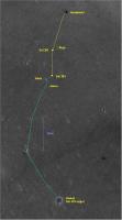
Here is an updated map of the road to Vostok.
Attached thumbnail(s)
|
|
 |
 
|
|
 |
|
Dec 29 2006, 12:04 PM
Post
#2
|
|
 Member Group: Members Posts: 559 Joined: 1-May 06 From: Scotland (Ecosse, Escocia) Member No.: 759 |
On a quick scan I count over 20 craters above 3m diameter inside Victoria, some very subdued and distorted. The drifting dunes are indeed a special case as you say Bob, but the slopes leading from the dune fringe to the base of the cliffs are surely a different "special case". These are talus slopes in motion, in a slow downward creep. The rate of creep (and therefore obliteration of features like little craters) will be greater with increased gradient, therefore greatest at the top of the slope near the cliff base. We know from the boulder track discussions that there is downward motion of erosional products. So I'm not surprised by seeing few extant craters anywhere inside Victoria, although I don't know the maths of cratering rates over time, versus obliteration.
Happy new year, when it comes Kenny |
|
|
|
 Pando Opportunity Route Map Feb 11 2005, 08:11 AM
 jamescanvin The 1027 drive direction pancams are pointed due e... Dec 15 2006, 01:24 AM
 hortonheardawho er, where did you see the 1027 drive direction pan... Dec 15 2006, 03:59 AM
 jamescanvin QUOTE (hortonheardawho @ Dec 15 2006, 02... Dec 15 2006, 05:10 AM hortonheardawho QUOTE (jamescanvin @ Dec 14 2006, 08:24 P... Dec 15 2006, 03:34 PM CosmicRocker QUOTE (jamescanvin @ Dec 14 2006, 04:03 P... Dec 15 2006, 07:11 AM Tesheiner My version for sol 1028.
Dec 15 2006, 05:34 PM MahFL Is Sofi Crater in this image ?
Sofi Crater ?
Tha... Dec 15 2006, 05:53 PM climber QUOTE (MahFL @ Dec 15 2006, 06:53 PM) Is ... Dec 15 2006, 08:07 PM Ant103 MahFL : Yes, of course !:)
" - You speak... Dec 15 2006, 06:08 PM Floyd The little crater with red letters at 5 o-clock. Dec 15 2006, 08:11 PM Tesheiner The little crater with red letters at 5 o-clock.
... Dec 15 2006, 09:00 PM atomoid "Sofi" crater... in that profound view
I... Dec 16 2006, 03:46 AM Tesheiner QUOTE (atomoid @ Dec 16 2006, 04:46 AM) O... Dec 16 2006, 07:52 AM BrianL QUOTE (atomoid @ Dec 15 2006, 09:46 PM) (... Dec 16 2006, 07:53 AM atomoid QUOTE (BrianL @ Dec 16 2006, 07:53 AM) Oh... Dec 19 2006, 09:58 PM jamescanvin Yup, Sofi Carter is a purely UMSF name, The JPL fo... Dec 16 2006, 04:48 AM mchan Imagine if Opportunity had bounced into Sofi crate... Dec 16 2006, 05:15 AM Floyd How did Opportunity drive through these little cra... Dec 16 2006, 03:51 PM um3k QUOTE (Floyd @ Dec 16 2006, 10:51 AM) How... Dec 16 2006, 08:39 PM Pando Speaking of Sofi / Bright Crater, I think it would... Dec 17 2006, 05:08 AM CosmicRocker Oh, wow. Thanks for that, Pando. I second the m... Dec 17 2006, 08:00 AM Myran I third it. Dec 17 2006, 11:21 AM kenny QUOTE (Floyd @ Dec 16 2006, 03:51 PM) How... Dec 17 2006, 12:47 PM Phil Stooke None of these names are really official, so I thin... Dec 17 2006, 02:43 PM Pando QUOTE (Phil Stooke @ Dec 17 2006, 06:43 A... Dec 17 2006, 07:44 PM Tesheiner Route map updated after driving on sol 1030.
Dec 17 2006, 07:11 PM Tesheiner Latest map version (sol 1032).
Dec 19 2006, 05:39 PM Tesheiner Mmm, guess I may use this contrast-enhanced versio... Dec 20 2006, 09:25 AM Tesheiner Latest map version (sol 1034).
Dec 22 2006, 04:42 PM Steve Here's a modification of Tesheiner's excel... Dec 23 2006, 05:56 PM Tesheiner Here is the route map, updated to sol 1039 and inc... Dec 27 2006, 09:41 AM ustrax QUOTE (Tesheiner @ Dec 27 2006, 09:41 AM)... Dec 29 2006, 04:23 PM Tesheiner Updated route map (sol 1041).
You will find two... Dec 29 2006, 09:26 AM Bob Shaw Has anyone noticed the relative numbers of small c... Dec 29 2006, 11:01 AM Tesheiner Done. Check it again here. Dec 29 2006, 09:07 PM ustrax QUOTE (Tesheiner @ Dec 29 2006, 09:07 PM)... Dec 29 2006, 10:42 PM CosmicRocker Fine tuning the various cratering rates seems to b... Dec 30 2006, 08:22 AM JonClarke QUOTE (CosmicRocker @ Dec 30 2006, 08:22 ... Dec 31 2006, 09:58 AM Bob Shaw QUOTE (JonClarke @ Dec 31 2006, 09:58 AM)... Dec 31 2006, 01:17 PM dvandorn Oh, there is definitely a story out there in terms... Dec 31 2006, 05:47 PM Shaka Yes, the radio-isotopes will be needed, but it see... Dec 31 2006, 07:06 PM Bob Shaw I suspect that with enough craters counted, and th... Dec 31 2006, 09:26 PM JonClarke QUOTE (Bob Shaw @ Dec 31 2006, 09:26 PM) ... Dec 31 2006, 10:50 PM Shaka QUOTE (JonClarke @ Dec 31 2006, 12:50 PM)... Jan 1 2007, 01:46 AM JonClarke QUOTE (Shaka @ Jan 1 2007, 01:46 AM) Pick... Jan 1 2007, 03:54 AM fredk A new feature name or two from the latest Planetar... Jan 1 2007, 08:07 PM Tesheiner Actually, I already updated my route map to includ... Jan 1 2007, 09:38 PM fredk That's right, the bays take the name of the ca... Jan 1 2007, 09:52 PM ustrax Tesheiner...
More work for you...
EDITED: Where ... Jan 3 2007, 12:39 PM Tesheiner Here are them. I had those places already updated ... Jan 3 2007, 01:49 PM Tesheiner QUOTE (Tesheiner @ Jan 3 2007, 02:49 PM) ... Jan 3 2007, 09:06 PM ustrax I was asking SS if, as, in my oppinion, Oppy is co... Jan 5 2007, 05:42 PM FIN Mars Why rover goes to there?
duck bay and bottomless ... Jan 3 2007, 02:06 PM Tesheiner > Why rover goes to there?
Because the search ... Jan 3 2007, 02:34 PM MarkL And SS has mentioned the stuff which most interest... Jan 3 2007, 04:24 PM Floyd Any idea what stuff that is? Jan 3 2007, 05:40 PM dot.dk QUOTE (ustrax @ Jan 5 2007, 06:42 PM) Fac... Jan 5 2007, 06:54 PM djellison There is nothing I see in Bottomless or Duck bays ... Jan 5 2007, 08:22 PM Bob Shaw I agree with the comments re the solar power const... Jan 5 2007, 10:15 PM CosmicRocker QUOTE (djellison @ Jan 5 2007, 02:22 PM) ... Jan 6 2007, 02:36 AM nprev You know, I see a lot of compelling reasons to go ... Jan 6 2007, 03:36 AM djellison There's only a movie of it on the JPL site som... Jan 6 2007, 10:58 AM edstrick There's relatively little science to be gained... Jan 6 2007, 11:34 AM BrianL To my way of thinking, the logical entry point wou... Jan 6 2007, 10:38 PM Bob Shaw QUOTE (edstrick @ Jan 6 2007, 11:34 AM) W... Jan 7 2007, 01:34 AM edstrick Both mossbauers are working fine... the shortish h... Jan 7 2007, 09:46 AM ustrax Via Nasawatch live blog:
"Opportunity is doi... Jan 9 2007, 05:30 PM MahFL Any one know what date the seasons officially chan... Jan 9 2007, 06:02 PM climber QUOTE (MahFL @ Jan 9 2007, 07:02 PM) So S... Jan 9 2007, 07:54 PM helvick QUOTE (MahFL @ Jan 9 2007, 06:02 PM) So S... Jan 9 2007, 09:24 PM centsworth_II QUOTE (ustrax @ Jan 9 2007, 12:30 PM) Via... Jan 9 2007, 06:37 PM ustrax QUOTE (centsworth_II @ Jan 9 2007, 06:37 ... Jan 10 2007, 09:41 AM hortonheardawho QUOTE (edstrick @ Jan 7 2007, 04:46 AM) B... Jan 9 2007, 05:56 PM Tesheiner Updated route map (sol 1055) including the names o... Jan 12 2007, 11:29 AM Tesheiner Updated route map (sol 1058).
Jan 15 2007, 01:54 PM Tesheiner Updated route map (sol 1060).
Jan 17 2007, 02:28 PM Tesheiner Updated route map (sol 1061).
Jan 18 2007, 02:20 PM stevesliva Thanks again for maintaining the map, Tesheiner... Jan 18 2007, 11:14 PM glennwsmith Yes, Tesheiner, your route maps are most appreciat... Jan 19 2007, 04:33 AM climber I also appreciated you screen shot. You may feel l... Jan 19 2007, 10:31 AM Tesheiner Thanks for the kind comments.
A bit "late... Jan 23 2007, 09:46 AM AlexBlackwell I moved this post from the "Bay of Toil... Jan 23 2007, 05:24 PM Tesheiner That's an "old" map from sol 1061, A... Jan 23 2007, 05:27 PM AlexBlackwell QUOTE (Tesheiner @ Jan 23 2007, 07:27 AM)... Jan 23 2007, 05:30 PM fredk The new official route map here or here has severa... Jan 23 2007, 05:28 PM Tesheiner QUOTE (fredk @ Jan 23 2007, 06:28 PM) The... Jan 24 2007, 03:24 PM ustrax Tesh, I believe you are correct.
Explorer?...
Did ... Jan 24 2007, 03:51 PM Tesheiner Just my guess, but if they named "Sputnik... Jan 24 2007, 04:11 PM djellison Going on craters being vessels of exploration.... ... Jan 24 2007, 04:13 PM Ant103 Yes, this is the official version...
There is an ... Jan 24 2007, 04:49 PM imipak QUOTE (Ant103 @ Jan 24 2007, 04:49 PM) Th... Jan 24 2007, 08:12 PM Tesheiner Arghh!!! That can't be true! Jan 24 2007, 04:52 PM djellison In that case, scrap 'Victoria' - it's ... Jan 24 2007, 04:54 PM Tesheiner Updated route map (sol 1067).
Jan 24 2007, 06:50 PM Bobby I was looking at Page 1 of this thread and when di... Jan 25 2007, 03:47 AM Tesheiner Updated route map (sol 1068).
Jan 25 2007, 05:19 PM Tesheiner Here we go again. The route map, updated to sol 10... Jan 26 2007, 08:27 PM Floyd They are going for it! The navcams are look... Jan 26 2007, 09:10 PM Tesheiner QUOTE (Floyd @ Jan 26 2007, 10:10 PM) ...... Jan 26 2007, 09:53 PM
jamescanvin QUOTE (hortonheardawho @ Dec 15 2006, 02... Dec 15 2006, 05:10 AM hortonheardawho QUOTE (jamescanvin @ Dec 14 2006, 08:24 P... Dec 15 2006, 03:34 PM CosmicRocker QUOTE (jamescanvin @ Dec 14 2006, 04:03 P... Dec 15 2006, 07:11 AM Tesheiner My version for sol 1028.
Dec 15 2006, 05:34 PM MahFL Is Sofi Crater in this image ?
Sofi Crater ?
Tha... Dec 15 2006, 05:53 PM climber QUOTE (MahFL @ Dec 15 2006, 06:53 PM) Is ... Dec 15 2006, 08:07 PM Ant103 MahFL : Yes, of course !:)
" - You speak... Dec 15 2006, 06:08 PM Floyd The little crater with red letters at 5 o-clock. Dec 15 2006, 08:11 PM Tesheiner The little crater with red letters at 5 o-clock.
... Dec 15 2006, 09:00 PM atomoid "Sofi" crater... in that profound view
I... Dec 16 2006, 03:46 AM Tesheiner QUOTE (atomoid @ Dec 16 2006, 04:46 AM) O... Dec 16 2006, 07:52 AM BrianL QUOTE (atomoid @ Dec 15 2006, 09:46 PM) (... Dec 16 2006, 07:53 AM atomoid QUOTE (BrianL @ Dec 16 2006, 07:53 AM) Oh... Dec 19 2006, 09:58 PM jamescanvin Yup, Sofi Carter is a purely UMSF name, The JPL fo... Dec 16 2006, 04:48 AM mchan Imagine if Opportunity had bounced into Sofi crate... Dec 16 2006, 05:15 AM Floyd How did Opportunity drive through these little cra... Dec 16 2006, 03:51 PM um3k QUOTE (Floyd @ Dec 16 2006, 10:51 AM) How... Dec 16 2006, 08:39 PM Pando Speaking of Sofi / Bright Crater, I think it would... Dec 17 2006, 05:08 AM CosmicRocker Oh, wow. Thanks for that, Pando. I second the m... Dec 17 2006, 08:00 AM Myran I third it. Dec 17 2006, 11:21 AM kenny QUOTE (Floyd @ Dec 16 2006, 03:51 PM) How... Dec 17 2006, 12:47 PM Phil Stooke None of these names are really official, so I thin... Dec 17 2006, 02:43 PM Pando QUOTE (Phil Stooke @ Dec 17 2006, 06:43 A... Dec 17 2006, 07:44 PM Tesheiner Route map updated after driving on sol 1030.
Dec 17 2006, 07:11 PM Tesheiner Latest map version (sol 1032).
Dec 19 2006, 05:39 PM Tesheiner Mmm, guess I may use this contrast-enhanced versio... Dec 20 2006, 09:25 AM Tesheiner Latest map version (sol 1034).
Dec 22 2006, 04:42 PM Steve Here's a modification of Tesheiner's excel... Dec 23 2006, 05:56 PM Tesheiner Here is the route map, updated to sol 1039 and inc... Dec 27 2006, 09:41 AM ustrax QUOTE (Tesheiner @ Dec 27 2006, 09:41 AM)... Dec 29 2006, 04:23 PM Tesheiner Updated route map (sol 1041).
You will find two... Dec 29 2006, 09:26 AM Bob Shaw Has anyone noticed the relative numbers of small c... Dec 29 2006, 11:01 AM Tesheiner Done. Check it again here. Dec 29 2006, 09:07 PM ustrax QUOTE (Tesheiner @ Dec 29 2006, 09:07 PM)... Dec 29 2006, 10:42 PM CosmicRocker Fine tuning the various cratering rates seems to b... Dec 30 2006, 08:22 AM JonClarke QUOTE (CosmicRocker @ Dec 30 2006, 08:22 ... Dec 31 2006, 09:58 AM Bob Shaw QUOTE (JonClarke @ Dec 31 2006, 09:58 AM)... Dec 31 2006, 01:17 PM dvandorn Oh, there is definitely a story out there in terms... Dec 31 2006, 05:47 PM Shaka Yes, the radio-isotopes will be needed, but it see... Dec 31 2006, 07:06 PM Bob Shaw I suspect that with enough craters counted, and th... Dec 31 2006, 09:26 PM JonClarke QUOTE (Bob Shaw @ Dec 31 2006, 09:26 PM) ... Dec 31 2006, 10:50 PM Shaka QUOTE (JonClarke @ Dec 31 2006, 12:50 PM)... Jan 1 2007, 01:46 AM JonClarke QUOTE (Shaka @ Jan 1 2007, 01:46 AM) Pick... Jan 1 2007, 03:54 AM fredk A new feature name or two from the latest Planetar... Jan 1 2007, 08:07 PM Tesheiner Actually, I already updated my route map to includ... Jan 1 2007, 09:38 PM fredk That's right, the bays take the name of the ca... Jan 1 2007, 09:52 PM ustrax Tesheiner...
More work for you...
EDITED: Where ... Jan 3 2007, 12:39 PM Tesheiner Here are them. I had those places already updated ... Jan 3 2007, 01:49 PM Tesheiner QUOTE (Tesheiner @ Jan 3 2007, 02:49 PM) ... Jan 3 2007, 09:06 PM ustrax I was asking SS if, as, in my oppinion, Oppy is co... Jan 5 2007, 05:42 PM FIN Mars Why rover goes to there?
duck bay and bottomless ... Jan 3 2007, 02:06 PM Tesheiner > Why rover goes to there?
Because the search ... Jan 3 2007, 02:34 PM MarkL And SS has mentioned the stuff which most interest... Jan 3 2007, 04:24 PM Floyd Any idea what stuff that is? Jan 3 2007, 05:40 PM dot.dk QUOTE (ustrax @ Jan 5 2007, 06:42 PM) Fac... Jan 5 2007, 06:54 PM djellison There is nothing I see in Bottomless or Duck bays ... Jan 5 2007, 08:22 PM Bob Shaw I agree with the comments re the solar power const... Jan 5 2007, 10:15 PM CosmicRocker QUOTE (djellison @ Jan 5 2007, 02:22 PM) ... Jan 6 2007, 02:36 AM nprev You know, I see a lot of compelling reasons to go ... Jan 6 2007, 03:36 AM djellison There's only a movie of it on the JPL site som... Jan 6 2007, 10:58 AM edstrick There's relatively little science to be gained... Jan 6 2007, 11:34 AM BrianL To my way of thinking, the logical entry point wou... Jan 6 2007, 10:38 PM Bob Shaw QUOTE (edstrick @ Jan 6 2007, 11:34 AM) W... Jan 7 2007, 01:34 AM edstrick Both mossbauers are working fine... the shortish h... Jan 7 2007, 09:46 AM ustrax Via Nasawatch live blog:
"Opportunity is doi... Jan 9 2007, 05:30 PM MahFL Any one know what date the seasons officially chan... Jan 9 2007, 06:02 PM climber QUOTE (MahFL @ Jan 9 2007, 07:02 PM) So S... Jan 9 2007, 07:54 PM helvick QUOTE (MahFL @ Jan 9 2007, 06:02 PM) So S... Jan 9 2007, 09:24 PM centsworth_II QUOTE (ustrax @ Jan 9 2007, 12:30 PM) Via... Jan 9 2007, 06:37 PM ustrax QUOTE (centsworth_II @ Jan 9 2007, 06:37 ... Jan 10 2007, 09:41 AM hortonheardawho QUOTE (edstrick @ Jan 7 2007, 04:46 AM) B... Jan 9 2007, 05:56 PM Tesheiner Updated route map (sol 1055) including the names o... Jan 12 2007, 11:29 AM Tesheiner Updated route map (sol 1058).
Jan 15 2007, 01:54 PM Tesheiner Updated route map (sol 1060).
Jan 17 2007, 02:28 PM Tesheiner Updated route map (sol 1061).
Jan 18 2007, 02:20 PM stevesliva Thanks again for maintaining the map, Tesheiner... Jan 18 2007, 11:14 PM glennwsmith Yes, Tesheiner, your route maps are most appreciat... Jan 19 2007, 04:33 AM climber I also appreciated you screen shot. You may feel l... Jan 19 2007, 10:31 AM Tesheiner Thanks for the kind comments.
A bit "late... Jan 23 2007, 09:46 AM AlexBlackwell I moved this post from the "Bay of Toil... Jan 23 2007, 05:24 PM Tesheiner That's an "old" map from sol 1061, A... Jan 23 2007, 05:27 PM AlexBlackwell QUOTE (Tesheiner @ Jan 23 2007, 07:27 AM)... Jan 23 2007, 05:30 PM fredk The new official route map here or here has severa... Jan 23 2007, 05:28 PM Tesheiner QUOTE (fredk @ Jan 23 2007, 06:28 PM) The... Jan 24 2007, 03:24 PM ustrax Tesh, I believe you are correct.
Explorer?...
Did ... Jan 24 2007, 03:51 PM Tesheiner Just my guess, but if they named "Sputnik... Jan 24 2007, 04:11 PM djellison Going on craters being vessels of exploration.... ... Jan 24 2007, 04:13 PM Ant103 Yes, this is the official version...
There is an ... Jan 24 2007, 04:49 PM imipak QUOTE (Ant103 @ Jan 24 2007, 04:49 PM) Th... Jan 24 2007, 08:12 PM Tesheiner Arghh!!! That can't be true! Jan 24 2007, 04:52 PM djellison In that case, scrap 'Victoria' - it's ... Jan 24 2007, 04:54 PM Tesheiner Updated route map (sol 1067).
Jan 24 2007, 06:50 PM Bobby I was looking at Page 1 of this thread and when di... Jan 25 2007, 03:47 AM Tesheiner Updated route map (sol 1068).
Jan 25 2007, 05:19 PM Tesheiner Here we go again. The route map, updated to sol 10... Jan 26 2007, 08:27 PM Floyd They are going for it! The navcams are look... Jan 26 2007, 09:10 PM Tesheiner QUOTE (Floyd @ Jan 26 2007, 10:10 PM) ...... Jan 26 2007, 09:53 PM |

|
Lo-Fi Version | Time is now: 20th June 2024 - 11:24 PM |
|
RULES AND GUIDELINES Please read the Forum Rules and Guidelines before posting. IMAGE COPYRIGHT |
OPINIONS AND MODERATION Opinions expressed on UnmannedSpaceflight.com are those of the individual posters and do not necessarily reflect the opinions of UnmannedSpaceflight.com or The Planetary Society. The all-volunteer UnmannedSpaceflight.com moderation team is wholly independent of The Planetary Society. The Planetary Society has no influence over decisions made by the UnmannedSpaceflight.com moderators. |
SUPPORT THE FORUM Unmannedspaceflight.com is funded by the Planetary Society. Please consider supporting our work and many other projects by donating to the Society or becoming a member. |
|