Bay of Toil |

Bay of Toil |
 Jan 12 2007, 08:46 AM Jan 12 2007, 08:46 AM
Post
#1
|
||
|
Senior Member  Group: Moderator Posts: 4279 Joined: 19-April 05 From: .br at .es Member No.: 253 |
Bay of Toil is on sight after sol 1055 drive.
http://nasa.exploratorium.edu/mars/opportu...AZP0645L0M1.JPG
|
|
 |
 
|
|
 |
|
Jan 16 2007, 01:17 AM
Post
#2
|
||
|
Solar System Cartographer Group: Members Posts: 10229 Joined: 5-April 05 From: Canada Member No.: 227 |
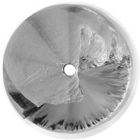
Here is jvandriel's 1058 pan in polar form.
Replying to Diane - we have to go in, but I'm not sure if there is a sanity level for driving round one of the capes! And regarding scree - outcrops are better than scree because you know where a sample came from - as was said - but on the other hand the multispectral and miniTES can help resolve those issues as well. Phil
Attached thumbnail(s)
-------------------- ... because the Solar System ain't gonna map itself.
Also to be found posting similar content on https://mastodon.social/@PhilStooke Maps for download (free PDF: https://upload.wikimedia.org/wikipedia/comm...Cartography.pdf NOTE: everything created by me which I post on UMSF is considered to be in the public domain (NOT CC, public domain) |
|
|
|
|
|
 Tesheiner Bay of Toil Jan 12 2007, 08:46 AM
 Stu Now THIS looks like an interesting spot for a picn... Jan 12 2007, 09:33 AM
 Marz QUOTE (Stu @ Jan 12 2007, 03:33 AM) Now T... Jan 12 2007, 09:17 PM djellison What might make a very interesting target for a we... Jan 12 2007, 11:56 AM Tesheiner "The dock", I like this name.
I... Jan 12 2007, 12:05 PM climber QUOTE (Tesheiner @ Jan 12 2007, 01:05 PM)... Jan 12 2007, 06:58 PM ElkGroveDan Climber you are going to make Stu jealous. Jan 12 2007, 09:22 PM Stu QUOTE (ElkGroveDan @ Jan 12 2007, 09:22 P... Jan 12 2007, 09:53 PM Stu Wow...
Jan 12 2007, 06:49 PM jvandriel Here is the Pancam L2 view of the Bay of Toil.
Ta... Jan 12 2007, 09:05 PM Stu Like I said, nice place for a picnic...
Jan 12 2007, 10:23 PM fredk Great new view today!
The slopes of Victoria ... Jan 12 2007, 10:51 PM alan There are a couple of streaks that appear to origi... Jan 12 2007, 11:24 PM Bob Shaw QUOTE (alan @ Jan 12 2007, 11:24 PM) Ther... Jan 12 2007, 11:43 PM MarsIsImportant QUOTE (alan @ Jan 12 2007, 05:24 PM) Ther... Jan 13 2007, 07:22 PM MarkL Thanks for that comparison fredk. The chevron dun... Jan 13 2007, 02:17 AM CosmicRocker Hehe, MarklL. It will be interesting to pass one ... Jan 13 2007, 07:52 AM climber QUOTE (CosmicRocker @ Jan 13 2007, 08:52 ... Jan 13 2007, 08:42 PM djellison Wahghg
I'm sat here wearing jeans and a shir... Jan 13 2007, 09:09 PM marsbug While you're there do you think you could drop... Jan 13 2007, 09:35 PM climber QUOTE (djellison @ Jan 13 2007, 10:09 PM)... Jan 14 2007, 05:57 AM CosmicRocker Nice one, climber. Hehe, poor Doug, standing ther... Jan 14 2007, 08:54 AM kenny QUOTE (climber @ Jan 13 2007, 08:42 PM) T... Jan 14 2007, 10:25 AM Astro0 It has been such a long time since a I last posted... Jan 14 2007, 10:12 PM climber QUOTE (Astro0 @ Jan 14 2007, 11:12 PM) It... Jan 15 2007, 01:00 AM Astro0 Climber said: "...What about a Sitting on the... Jan 15 2007, 03:29 AM Tesheiner Fresh navcams from sol 1058 at the exploratorium: ... Jan 15 2007, 11:45 AM Airbag QUOTE (Tesheiner @ Jan 15 2007, 06:45 AM)... Jan 15 2007, 04:18 PM climber QUOTE (Airbag @ Jan 15 2007, 05:18 PM) Th... Jan 15 2007, 11:24 PM Bob Shaw QUOTE (climber @ Jan 15 2007, 11:24 PM) T... Jan 15 2007, 11:57 PM climber QUOTE (Bob Shaw @ Jan 16 2007, 12:57 AM) ... Jan 16 2007, 12:32 AM Airbag QUOTE (climber @ Jan 15 2007, 06:24 PM) T... Jan 16 2007, 03:05 AM edstrick What we need is a Burroughsian Green Martian, 4 ar... Jan 15 2007, 11:55 AM Stu
Loving this view as it opens up... Jan 15 2007, 01:09 PM MarsIsImportant It looks like we possibly found a way OUT of Victo... Jan 15 2007, 04:55 PM ronatu QUOTE (MarsIsImportant @ Jan 15 2007, 11... Jan 16 2007, 04:46 PM diane If we go in through one bay and plan to come out t... Jan 15 2007, 07:10 PM jvandriel Here is the complete 360 degree panoramic view fro... Jan 15 2007, 09:11 PM mhoward Sol 1058 Jan 16 2007, 03:45 AM dilo QUOTE (mhoward @ Jan 16 2007, 04:45 AM) S... Jan 16 2007, 09:37 PM CosmicRocker Thanks for the updates. Some of us were eagerly a... Jan 16 2007, 06:19 AM Tesheiner Few activities (if any) tosol at VC, isn't it? Jan 16 2007, 05:38 PM Astro0 I really love those polar projections from Dilo an... Jan 17 2007, 12:37 AM Nix QUOTE (Astro0 @ Jan 17 2007, 01:37 AM) PS... Jan 17 2007, 01:58 PM Tesheiner These are the planned sequences for sol 1060 and 1... Jan 17 2007, 07:19 AM Tesheiner QUOTE (Tesheiner @ Jan 17 2007, 08:19 AM)... Jan 17 2007, 10:54 AM djellison Due north of current position - imaging toward the... Jan 17 2007, 11:42 AM Tesheiner Bingo!
That was my guess. However, I have to ... Jan 17 2007, 01:46 PM Stu Lovely layers...
Jan 17 2007, 02:35 PM Tesheiner Nice view, indeed. I'm wondering if they plan ... Jan 17 2007, 02:53 PM Stu Epic rock at the base here...
Jan 17 2007, 04:05 PM Tesheiner FWIW, the plan for sol 1061 includes a similar pan... Jan 17 2007, 08:58 PM OWW QUOTE (Tesheiner @ Jan 17 2007, 09:58 PM)... Jan 17 2007, 11:10 PM jamescanvin QUOTE (OWW @ Jan 18 2007, 10:10 AM) Looks... Jan 17 2007, 11:30 PM Tesheiner QUOTE (OWW @ Jan 18 2007, 12:10 AM) Looks... Jan 18 2007, 08:37 AM jamescanvin Here is what we have so far:
James Jan 17 2007, 11:09 PM alan QUOTE (jamescanvin @ Jan 17 2007, 05:30 P... Jan 18 2007, 01:26 PM jamescanvin QUOTE (alan @ Jan 19 2007, 12:26 AM) Coul... Jan 18 2007, 08:49 PM Tesheiner Meanwhile, Oppy moved due north (11m) on sol 1061.... Jan 18 2007, 02:13 PM climber QUOTE (Tesheiner @ Jan 18 2007, 03:13 PM)... Jan 18 2007, 02:26 PM Tesheiner > Would ne nice to test the new software and tr... Jan 18 2007, 02:55 PM Ant103 Very impressive images there. You're very nice... Jan 18 2007, 04:49 PM Stu Looking forward to seeing all your true-colour ver... Jan 18 2007, 06:14 PM jvandriel Stu,
how is it possible ?
Looking in the directi... Jan 18 2007, 08:34 PM Stu QUOTE (jvandriel @ Jan 18 2007, 08:34 PM)... Jan 18 2007, 09:22 PM jvandriel Very nice Stu.
jvandriel
Enjoy your work. Jan 18 2007, 09:43 PM jamescanvin I see now that I was getting confused. I was think... Jan 18 2007, 11:25 PM Tesheiner QUOTE (jamescanvin @ Jan 19 2007, 12:25 A... Jan 19 2007, 09:53 AM jamescanvin QUOTE (Tesheiner @ Jan 19 2007, 08:53 PM)... Jan 20 2007, 12:18 AM jamescanvin QUOTE (Tesheiner @ Jan 19 2007, 08:53 PM)... Jan 20 2007, 01:39 AM Greg Hullender I keep wanting to use some of these beautiful Vict... Jan 19 2007, 04:53 AM jamescanvin Well all the raw images are 1024x1024 but the pans... Jan 19 2007, 05:19 AM CosmicRocker QUOTE (jamescanvin @ Jan 18 2007, 05:25 P... Jan 19 2007, 06:11 AM jamescanvin QUOTE (CosmicRocker @ Jan 19 2007, 05:11 ... Jan 19 2007, 06:24 AM Floyd No data down from Opportunity today? Jan 19 2007, 06:00 PM Tesheiner Can't find any at the exploratorium or the pan... Jan 19 2007, 08:44 PM fredk From the latest update,QUOTE Opportunity was sched... Jan 20 2007, 12:37 AM Stu Hmmmm... I doubt the comet will look very impre... Jan 20 2007, 01:08 AM jamescanvin QUOTE (Stu @ Jan 20 2007, 12:08 PM) I dou... Jan 20 2007, 01:29 AM Stu QUOTE (jamescanvin @ Jan 20 2007, 01:29 A... Jan 20 2007, 08:26 AM Bob Shaw QUOTE (Stu @ Jan 20 2007, 01:08 AM) Hmmmm... Jan 20 2007, 01:56 PM CosmicRocker QUOTE (fredk @ Jan 19 2007, 06:37 PM) Fro... Jan 20 2007, 06:24 AM diane QUOTE (CosmicRocker @ Jan 20 2007, 01:24 ... Jan 20 2007, 10:49 PM nprev I seem to recall an old painting that showed a maj... Jan 20 2007, 07:03 AM Stu QUOTE (nprev @ Jan 20 2007, 07:03 AM) I s... Jan 20 2007, 08:49 AM nprev QUOTE (Stu @ Jan 20 2007, 12:49 AM) This ... Jan 20 2007, 07:10 PM Sunspot Images from Opportunity are down, nothing obvious ... Jan 20 2007, 03:35 PM Phil Stooke I used those new images to look instead at the dis... Jan 20 2007, 04:51 PM jvandriel Here is the L0 Navcam panoramic view from Sol 1061... Jan 21 2007, 02:52 PM hortonheardawho This is three of the 9 L4/R1 pairs shot just befor... Jan 21 2007, 07:37 PM fredk Yeah, I can see nothing in Spirit's attempt as... Jan 22 2007, 12:53 AM Tesheiner Oppy drove again on sol 1064 (navcams, pancams).
... Jan 22 2007, 09:03 AM antoniseb Hmmm. I'd expected that they'd make a clos... Jan 22 2007, 08:14 PM Marz QUOTE (antoniseb @ Jan 22 2007, 02:14 PM)... Jan 22 2007, 08:23 PM Tesheiner I wouldn't rule out the dock yet. It could be ... Jan 22 2007, 08:38 PM jvandriel Here is the panoramic view from Sol 1064.
Taken w... Jan 22 2007, 08:49 PM mhoward Look at this jutting rock! I hadn't notice... Jan 23 2007, 03:30 AM climber QUOTE (mhoward @ Jan 23 2007, 04:30 AM) L... Jan 23 2007, 08:50 AM CosmicRocker QUOTE (Tesheiner @ Jan 22 2007, 02:38 PM)... Jan 23 2007, 06:22 AM
Marz QUOTE (Stu @ Jan 12 2007, 03:33 AM) Now T... Jan 12 2007, 09:17 PM djellison What might make a very interesting target for a we... Jan 12 2007, 11:56 AM Tesheiner "The dock", I like this name.
I... Jan 12 2007, 12:05 PM climber QUOTE (Tesheiner @ Jan 12 2007, 01:05 PM)... Jan 12 2007, 06:58 PM ElkGroveDan Climber you are going to make Stu jealous. Jan 12 2007, 09:22 PM Stu QUOTE (ElkGroveDan @ Jan 12 2007, 09:22 P... Jan 12 2007, 09:53 PM Stu Wow...
Jan 12 2007, 06:49 PM jvandriel Here is the Pancam L2 view of the Bay of Toil.
Ta... Jan 12 2007, 09:05 PM Stu Like I said, nice place for a picnic...
Jan 12 2007, 10:23 PM fredk Great new view today!
The slopes of Victoria ... Jan 12 2007, 10:51 PM alan There are a couple of streaks that appear to origi... Jan 12 2007, 11:24 PM Bob Shaw QUOTE (alan @ Jan 12 2007, 11:24 PM) Ther... Jan 12 2007, 11:43 PM MarsIsImportant QUOTE (alan @ Jan 12 2007, 05:24 PM) Ther... Jan 13 2007, 07:22 PM MarkL Thanks for that comparison fredk. The chevron dun... Jan 13 2007, 02:17 AM CosmicRocker Hehe, MarklL. It will be interesting to pass one ... Jan 13 2007, 07:52 AM climber QUOTE (CosmicRocker @ Jan 13 2007, 08:52 ... Jan 13 2007, 08:42 PM djellison Wahghg
I'm sat here wearing jeans and a shir... Jan 13 2007, 09:09 PM marsbug While you're there do you think you could drop... Jan 13 2007, 09:35 PM climber QUOTE (djellison @ Jan 13 2007, 10:09 PM)... Jan 14 2007, 05:57 AM CosmicRocker Nice one, climber. Hehe, poor Doug, standing ther... Jan 14 2007, 08:54 AM kenny QUOTE (climber @ Jan 13 2007, 08:42 PM) T... Jan 14 2007, 10:25 AM Astro0 It has been such a long time since a I last posted... Jan 14 2007, 10:12 PM climber QUOTE (Astro0 @ Jan 14 2007, 11:12 PM) It... Jan 15 2007, 01:00 AM Astro0 Climber said: "...What about a Sitting on the... Jan 15 2007, 03:29 AM Tesheiner Fresh navcams from sol 1058 at the exploratorium: ... Jan 15 2007, 11:45 AM Airbag QUOTE (Tesheiner @ Jan 15 2007, 06:45 AM)... Jan 15 2007, 04:18 PM climber QUOTE (Airbag @ Jan 15 2007, 05:18 PM) Th... Jan 15 2007, 11:24 PM Bob Shaw QUOTE (climber @ Jan 15 2007, 11:24 PM) T... Jan 15 2007, 11:57 PM climber QUOTE (Bob Shaw @ Jan 16 2007, 12:57 AM) ... Jan 16 2007, 12:32 AM Airbag QUOTE (climber @ Jan 15 2007, 06:24 PM) T... Jan 16 2007, 03:05 AM edstrick What we need is a Burroughsian Green Martian, 4 ar... Jan 15 2007, 11:55 AM Stu
Loving this view as it opens up... Jan 15 2007, 01:09 PM MarsIsImportant It looks like we possibly found a way OUT of Victo... Jan 15 2007, 04:55 PM ronatu QUOTE (MarsIsImportant @ Jan 15 2007, 11... Jan 16 2007, 04:46 PM diane If we go in through one bay and plan to come out t... Jan 15 2007, 07:10 PM jvandriel Here is the complete 360 degree panoramic view fro... Jan 15 2007, 09:11 PM mhoward Sol 1058 Jan 16 2007, 03:45 AM dilo QUOTE (mhoward @ Jan 16 2007, 04:45 AM) S... Jan 16 2007, 09:37 PM CosmicRocker Thanks for the updates. Some of us were eagerly a... Jan 16 2007, 06:19 AM Tesheiner Few activities (if any) tosol at VC, isn't it? Jan 16 2007, 05:38 PM Astro0 I really love those polar projections from Dilo an... Jan 17 2007, 12:37 AM Nix QUOTE (Astro0 @ Jan 17 2007, 01:37 AM) PS... Jan 17 2007, 01:58 PM Tesheiner These are the planned sequences for sol 1060 and 1... Jan 17 2007, 07:19 AM Tesheiner QUOTE (Tesheiner @ Jan 17 2007, 08:19 AM)... Jan 17 2007, 10:54 AM djellison Due north of current position - imaging toward the... Jan 17 2007, 11:42 AM Tesheiner Bingo!
That was my guess. However, I have to ... Jan 17 2007, 01:46 PM Stu Lovely layers...
Jan 17 2007, 02:35 PM Tesheiner Nice view, indeed. I'm wondering if they plan ... Jan 17 2007, 02:53 PM Stu Epic rock at the base here...
Jan 17 2007, 04:05 PM Tesheiner FWIW, the plan for sol 1061 includes a similar pan... Jan 17 2007, 08:58 PM OWW QUOTE (Tesheiner @ Jan 17 2007, 09:58 PM)... Jan 17 2007, 11:10 PM jamescanvin QUOTE (OWW @ Jan 18 2007, 10:10 AM) Looks... Jan 17 2007, 11:30 PM Tesheiner QUOTE (OWW @ Jan 18 2007, 12:10 AM) Looks... Jan 18 2007, 08:37 AM jamescanvin Here is what we have so far:
James Jan 17 2007, 11:09 PM alan QUOTE (jamescanvin @ Jan 17 2007, 05:30 P... Jan 18 2007, 01:26 PM jamescanvin QUOTE (alan @ Jan 19 2007, 12:26 AM) Coul... Jan 18 2007, 08:49 PM Tesheiner Meanwhile, Oppy moved due north (11m) on sol 1061.... Jan 18 2007, 02:13 PM climber QUOTE (Tesheiner @ Jan 18 2007, 03:13 PM)... Jan 18 2007, 02:26 PM Tesheiner > Would ne nice to test the new software and tr... Jan 18 2007, 02:55 PM Ant103 Very impressive images there. You're very nice... Jan 18 2007, 04:49 PM Stu Looking forward to seeing all your true-colour ver... Jan 18 2007, 06:14 PM jvandriel Stu,
how is it possible ?
Looking in the directi... Jan 18 2007, 08:34 PM Stu QUOTE (jvandriel @ Jan 18 2007, 08:34 PM)... Jan 18 2007, 09:22 PM jvandriel Very nice Stu.
jvandriel
Enjoy your work. Jan 18 2007, 09:43 PM jamescanvin I see now that I was getting confused. I was think... Jan 18 2007, 11:25 PM Tesheiner QUOTE (jamescanvin @ Jan 19 2007, 12:25 A... Jan 19 2007, 09:53 AM jamescanvin QUOTE (Tesheiner @ Jan 19 2007, 08:53 PM)... Jan 20 2007, 12:18 AM jamescanvin QUOTE (Tesheiner @ Jan 19 2007, 08:53 PM)... Jan 20 2007, 01:39 AM Greg Hullender I keep wanting to use some of these beautiful Vict... Jan 19 2007, 04:53 AM jamescanvin Well all the raw images are 1024x1024 but the pans... Jan 19 2007, 05:19 AM CosmicRocker QUOTE (jamescanvin @ Jan 18 2007, 05:25 P... Jan 19 2007, 06:11 AM jamescanvin QUOTE (CosmicRocker @ Jan 19 2007, 05:11 ... Jan 19 2007, 06:24 AM Floyd No data down from Opportunity today? Jan 19 2007, 06:00 PM Tesheiner Can't find any at the exploratorium or the pan... Jan 19 2007, 08:44 PM fredk From the latest update,QUOTE Opportunity was sched... Jan 20 2007, 12:37 AM Stu Hmmmm... I doubt the comet will look very impre... Jan 20 2007, 01:08 AM jamescanvin QUOTE (Stu @ Jan 20 2007, 12:08 PM) I dou... Jan 20 2007, 01:29 AM Stu QUOTE (jamescanvin @ Jan 20 2007, 01:29 A... Jan 20 2007, 08:26 AM Bob Shaw QUOTE (Stu @ Jan 20 2007, 01:08 AM) Hmmmm... Jan 20 2007, 01:56 PM CosmicRocker QUOTE (fredk @ Jan 19 2007, 06:37 PM) Fro... Jan 20 2007, 06:24 AM diane QUOTE (CosmicRocker @ Jan 20 2007, 01:24 ... Jan 20 2007, 10:49 PM nprev I seem to recall an old painting that showed a maj... Jan 20 2007, 07:03 AM Stu QUOTE (nprev @ Jan 20 2007, 07:03 AM) I s... Jan 20 2007, 08:49 AM nprev QUOTE (Stu @ Jan 20 2007, 12:49 AM) This ... Jan 20 2007, 07:10 PM Sunspot Images from Opportunity are down, nothing obvious ... Jan 20 2007, 03:35 PM Phil Stooke I used those new images to look instead at the dis... Jan 20 2007, 04:51 PM jvandriel Here is the L0 Navcam panoramic view from Sol 1061... Jan 21 2007, 02:52 PM hortonheardawho This is three of the 9 L4/R1 pairs shot just befor... Jan 21 2007, 07:37 PM fredk Yeah, I can see nothing in Spirit's attempt as... Jan 22 2007, 12:53 AM Tesheiner Oppy drove again on sol 1064 (navcams, pancams).
... Jan 22 2007, 09:03 AM antoniseb Hmmm. I'd expected that they'd make a clos... Jan 22 2007, 08:14 PM Marz QUOTE (antoniseb @ Jan 22 2007, 02:14 PM)... Jan 22 2007, 08:23 PM Tesheiner I wouldn't rule out the dock yet. It could be ... Jan 22 2007, 08:38 PM jvandriel Here is the panoramic view from Sol 1064.
Taken w... Jan 22 2007, 08:49 PM mhoward Look at this jutting rock! I hadn't notice... Jan 23 2007, 03:30 AM climber QUOTE (mhoward @ Jan 23 2007, 04:30 AM) L... Jan 23 2007, 08:50 AM CosmicRocker QUOTE (Tesheiner @ Jan 22 2007, 02:38 PM)... Jan 23 2007, 06:22 AM |

|
Lo-Fi Version | Time is now: 27th September 2024 - 03:07 AM |
|
RULES AND GUIDELINES Please read the Forum Rules and Guidelines before posting. IMAGE COPYRIGHT |
OPINIONS AND MODERATION Opinions expressed on UnmannedSpaceflight.com are those of the individual posters and do not necessarily reflect the opinions of UnmannedSpaceflight.com or The Planetary Society. The all-volunteer UnmannedSpaceflight.com moderation team is wholly independent of The Planetary Society. The Planetary Society has no influence over decisions made by the UnmannedSpaceflight.com moderators. |
SUPPORT THE FORUM Unmannedspaceflight.com is funded by the Planetary Society. Please consider supporting our work and many other projects by donating to the Society or becoming a member. |
|