Titan's Equatorial Sand Seas |

Titan's Equatorial Sand Seas |
 May 7 2007, 03:53 PM May 7 2007, 03:53 PM
Post
#1
|
|||||||
 Senior Member  Group: Moderator Posts: 2785 Joined: 10-November 06 From: Pasadena, CA Member No.: 1345 |
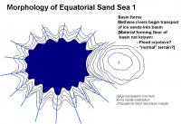
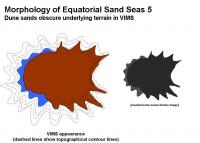
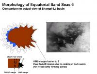
Ive put together a sequence of events that could explain the morphology of the Equatorial Sand Seas. (An example basin similar to Shangri-La is shown)
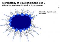
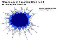
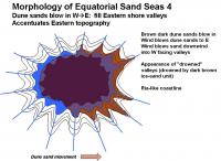
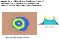
This could explain the ria-like topography [http://en.wikipedia.org/wiki/Ria] on the Eastern shore, as well as the VIMS dark blue western parts of the Sand seas, and the placement of the dark brown unit on the Eastern parts of the sand seas. 1. Basin formation. 2. Water-ice sand deposition [slowly, suddenly?] forms an ice-sand margin 3. Mobile dark brown dune sands deposit on E side, depositing inland up W facing valleys.
:attachment] The dark brown sands will blow in following the predominantly W winds and make a dust coating on low-lying terrains on the eastern margins. This will be visible by VIMS and ISS as the dark-bright margin, placed inland from the "real margin" and will accentuate the local topography as seen by optical instruments. This accentuation on the E margin will make the Equatorial Sand Sea visible margin look swoopy and windblown (in effect, it is) from the dark basin. Similarly, the W margin will have a dark blue zone that appears blown from the western bright areas. On the Eastern shore, the RADAR images will place the smooth-dark/mottled gray boundary far to the W of the VIMS brown dark-bright margin. (RADAR should be able to penetrate a thin coating of dark sands). The features in the limbo zone have been covered by dark sands, perhaps not enough to form dune structures, but enough to cover up the ice-sand margin, the near shore terrain, and perhaps even some of the underlying bright terrain. This makes the deposition sequence in the Equatorial Sand Seas: 1: Basin formation 2. Major water ice sand emplacement 3. Dune sands cover up low-lying downwind valleys (enough to mask visible imagery) Other Equatorial Sand Sea basins should look very similar around Titan: Shangri-La, Belet, Senkyo, Fensal and Quivra. Local winds may play a bonus role, but the overall trend of dark sand deposition up valley should be towards the E. For example: the false-color image in Figure 6 of the Soderblom paper seems to imply a predominant wind vector in Fensal and Quivra to the ESE. [Im pretty sure all this has been described in pieces before, but it gave me a really great excuse to play with PowerPoint.  ] ]-Mike
Attached thumbnail(s)
-------------------- Some higher resolution images available at my photostream: http://www.flickr.com/photos/31678681@N07/
|
||||||
 |
 
|
||||||
 |
|
May 14 2007, 03:00 PM
Post
#2
|
|||||||||||
|
Senior Member Group: Moderator Posts: 2785 Joined: 10-November 06 From: Pasadena, CA Member No.: 1345 |
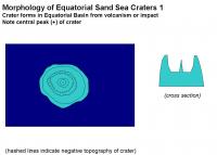
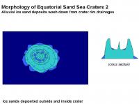
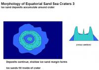
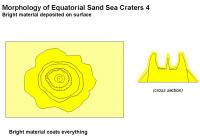
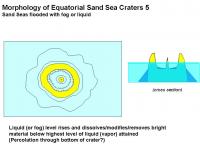
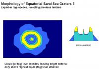
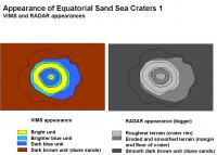
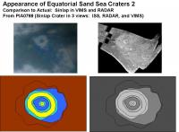
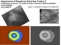
Ive put together a hypothetical sequence that could explain the RADAR and VIMS appearance of the craters observed in the Equatorial Sand Seas. (Craters such as Sinlap, the T17 swath crater in W Fensal, and Guabonito). This sequence also explains the puzzling appearance of the bright material which highlights the crater rims and central peaks.
1. Crater forms, either before or after the Sand Sea basin forms or is partially filled in.. 2. Water ice sand erodes on outside of crater, forming a debris apron or ice sand margin. 3. Bright material is deposited. 4. Liquid or fog percolates up to a set topographic level at the crater. All bright material below this line (highest sea level) is dissolved/modified/washed away. 5. The liquid (fog) level retreats, leaving crater high and dry and revealing previous units. 6. Mobile dark brown dune sands deposited on W side, but dont fill in downwind (E) in the wind shadow of the crater. Here are some examples of what we would expect to observe from this scenario, compared to actual VIMS and RADAR images:
This nicely explains the bright material deposited on the rim of the crater, but not on the blue ice sand margins (in some of the craters like Sinlap). It also explains the bright deposit on the central peaks of Sinlap, as well as on the central peak of the crater-shaped feature NE of the Huygens Landing Site (seen in ISS).. The key to this sequence is that the bright material was deposited BEFORE the last major sea level rise. It is possible that each item in the sequence is periodic, rather than a one time deal. So the deposition of bright material is episodic and rare, floods are less rare, and dune sands move quite often. The bright/dark line around the Equatorial Dune Seas are fixed by the last major sea level height attained in that basin after bright material was deposited. Craters that formed environments that were eventually deeply flooded will have a significant light blue and dark blue sand ice margin that extends outside the brightest material deposit (especially to the W). They will have a bulls-eye pattern in VIMS. Those craters that formed in areas that were only slightly covered in liquid at its highest point will have a very small blue ice sand margin that extends beyond the bright material these will have a very asymmetric look in VIMS (strong trailing to the E). Some craters were never inundated and thus would only have bright material covering the entire crater complex these may not show up by VIMS, only by RADAR. Craters that formed in what was eventually a deep liquid environments include Sinlap, the Western T17 RADAR swath crater in Fensal, and Guabonito. Craters that fomed in an enviroment that was eventually shallowly covered in liquid include Minerva, and the crater(?) that is on the W tip of Quivra (seen in the T25 RADAR swath) Craters that formed in environments that were never inundated include the crater on the N end of Shikoku Faculae. (not obvious in ISS, but seen in RADAR). By this analogy, Fensal is deeper than Aztlan. And Shangri-La nearest Xanadu is deep (subduction?) and Shangri La is very shallow near its contact with Adiri. In general, areas with steep shorelines (highest level attained after the last bright stuff deposition event) will have fewer indentations and have a smoother light/dark border (i.e. Xanadu). Areas with shallow shores with relative highest topography closest to highest sea level height will have very jagged and irregular bright/dark borders (ancient bright stuff/liquid shorelines). From this we would predict that average elevation of Adiri is very close to the highest attained level. It may be an area that has been gently upwarped to a level just slightly above the highest attained sea level in Shangri-La basin after the last bright stuff deposition event. The bright island at the Huygens Landing Site sits just above the level of the highest level of liquid attained in Shangri-La after the last bright stuff deposition event. The bright/dark contact line of the highland sits at the highest level of liquid attained in the Shangri-La basin. In the channel some of the sand bars have bright material deposited on them. This should allow us to link the two units. The bright stuff on the sand bars would also be just poking above the highest level of liquid attained in the Shangri-La basin after the last bright stuff deposition event.. The analogy of the Great Basin of North America, painted white, and then flooded with a Glacial Lake Bonneville amount of turpentine and then drained seems pretty close. (Possibly very close chemically). -Mike -------------------- Some higher resolution images available at my photostream: http://www.flickr.com/photos/31678681@N07/
|
||||||||||
|
|
|
||||||||||
 Juramike Titan's Equatorial Sand Seas May 7 2007, 03:53 PM
 Juramike Ive put together another hypothetical series of e... May 8 2007, 11:44 PM
 volcanopele QUOTE (Juramike @ May 8 2007, 04:44 PM) I... May 10 2007, 07:15 PM ngunn Just in case you're wondering Mike I'm fol... May 9 2007, 02:39 PM Juramike QUOTE (ngunn @ May 9 2007, 10:39 AM) Also... May 9 2007, 05:35 PM Littlebit QUOTE (ngunn @ May 9 2007, 08:39 AM) Just... May 9 2007, 05:55 PM Juramike Here is an example of a smaller isolated Dune Sea.... May 11 2007, 10:08 PM remcook I think a massive rain storm around the equator mi... May 9 2007, 02:51 PM Juramike There are a few examples of both RADAR dark and RA... May 10 2007, 11:00 PM ngunn QUOTE (Juramike @ May 11 2007, 12:00 AM) ... May 11 2007, 07:04 PM Juramike QUOTE (ngunn @ May 11 2007, 03:04 PM) Nic... May 11 2007, 07:34 PM rlorenz QUOTE (Juramike @ May 11 2007, 03:34 PM) ... May 12 2007, 03:40 PM ngunn [quote name='rlorenz' date='May 12 200... May 12 2007, 08:01 PM Juramike Here are some images and locations where dunes hav... May 11 2007, 09:46 PM lyford Thanks for all the awesomeness, Juramike May 12 2007, 03:10 AM ngunn Mike, in your first illustration in post 11 (for e... May 12 2007, 07:35 PM Matt I stumbled a publication (PDF) entitled: 'Com... May 13 2007, 09:23 PM Matt I stumbled upon a publication, rather. May 13 2007, 09:28 PM Mongo ^link?
Bill May 13 2007, 10:28 PM Matt http://www.lpi.usra.edu/meetings/lpsc2007/pdf/2222... May 13 2007, 11:00 PM Exploitcorporations This seems like as good a place as any to deposit ... May 14 2007, 06:30 PM Juramike Wow! Thank you, Exploitcorporations!
(Lo... May 14 2007, 06:40 PM volcanopele QUOTE (Juramike @ May 14 2007, 11:40 AM) ... May 14 2007, 07:44 PM Juramike QUOTE (volcanopele @ May 14 2007, 03:44 P... May 14 2007, 09:15 PM remcook simply...wow! amazing how sharp it is! May 14 2007, 07:06 PM Juramike QUOTE (rlorenz @ May 12 2007, 11:40 AM) W... May 14 2007, 08:22 PM volcanopele hmm, I suspect that the feature you thought was Ks... May 14 2007, 09:29 PM Juramike Are there easy ways to discern between a cryovolca... May 14 2007, 09:40 PM volcanopele Well, it would be nice if it erupted. That would ... May 14 2007, 09:56 PM Juramike Hmmm. Actually, there might be a way to see a rec... May 17 2007, 06:43 PM Exploitcorporations Here's another work in progress. This makeover... May 18 2007, 01:35 AM Phil Stooke Very nice. I hope you will do more of these.
Phi... May 18 2007, 01:48 AM belleraphon1 Exploitcorporations
All your work is breathtaking... May 18 2007, 02:09 AM Juramike Wow!! That is totally awesome!!... May 18 2007, 03:28 PM Juramike One of the dark channels from the T8 RADAR swath ... May 21 2007, 08:06 PM helvick Surely Titan's Saturn synchronous orbit would ... May 21 2007, 08:19 PM Juramike QUOTE (helvick @ May 21 2007, 04:19 PM) S... May 21 2007, 08:34 PM alan I remember reading a paper before Cassini reached ... May 22 2007, 01:04 AM AlexBlackwell QUOTE (alan @ May 21 2007, 03:04 PM) I re... May 22 2007, 01:44 AM Mongo If Titan had global oceans on its surface, its tid... May 22 2007, 01:42 AM ngunn We have a beautiful example of a tidal channel her... May 22 2007, 09:28 AM ngunn Menai Strait chart attached:
Note that this is q... May 22 2007, 12:17 PM Juramike (I sooooo totally could not resist this...)
Furt... May 22 2007, 02:24 PM ngunn If we are saying that the equatorial basins once c... May 22 2007, 04:33 PM Juramike QUOTE (ngunn @ May 22 2007, 12:33 PM) If ... May 22 2007, 06:02 PM David Are the sand basins really very far below the surr... May 22 2007, 07:10 PM Juramike QUOTE (David @ May 22 2007, 03:10 PM) Are... May 23 2007, 02:28 PM ngunn Another question, Mike. I'm looking at the ... May 23 2007, 02:53 PM Littlebit Excellant theory, Mike. If the sand dunes are stil... May 23 2007, 03:16 PM Juramike Ngunn, it fits pretty close.
I suspect that there... May 23 2007, 03:23 PM ngunn I certainly find these ideas plausible - and now y... May 23 2007, 03:50 PM alan Would the strength of these tides tides vary with ... May 24 2007, 01:00 AM rlorenz QUOTE (alan @ May 23 2007, 09:00 PM) Woul... May 26 2007, 01:29 PM Juramike QUOTE (rlorenz @ May 26 2007, 09:29 AM) A... Jun 4 2007, 04:31 PM ngunn QUOTE (Juramike @ Jun 4 2007, 05:31 PM) F... Jun 5 2007, 10:32 AM Juramike QUOTE (ngunn @ Jun 5 2007, 06:32 AM) Are ... Jun 5 2007, 04:34 PM ngunn QUOTE (Juramike @ Jun 4 2007, 05:31 PM) I... Jun 5 2007, 11:12 AM Juramike QUOTE (ngunn @ Jun 5 2007, 07:12 AM) I... Jun 5 2007, 05:52 PM ngunn QUOTE (Juramike @ Jun 5 2007, 06:52 PM) b... Jun 5 2007, 08:12 PM Juramike QUOTE (ngunn @ Jun 5 2007, 04:12 PM) The ... Jun 5 2007, 09:10 PM ngunn QUOTE (Juramike @ Jun 5 2007, 10:10 PM) H... Jun 6 2007, 10:07 AM Juramike I used the published altimetry data to try and est... May 29 2007, 04:33 PM JRehling QUOTE (Juramike @ May 29 2007, 09:33 AM) ... May 29 2007, 05:10 PM Juramike I used the "ski tracks" feature in the T... May 29 2007, 06:18 PM Stu Fascinating reading as always Juramike, thanks. Yo... May 29 2007, 06:45 PM Juramike My WAG about the "dancing monkey" or ... May 29 2007, 07:17 PM ngunn Well, one striking characteristic of the 'hood... Jun 5 2007, 06:07 PM Juramike That's a really good point on the clean-lookin... Jun 5 2007, 07:46 PM Juramike Following the calculations in the Sagan, Dermott, ... Jun 5 2007, 10:07 PM Juramike Does anyone have an idea what the heck these are? ... Jun 5 2007, 10:18 PM ngunn QUOTE (Juramike @ Jun 5 2007, 11:18 PM) D... Jun 6 2007, 02:47 PM ngunn A further thought - two plausible eruption product... Jun 6 2007, 12:02 PM Juramike Cryopumice is a very interesting concept. Those t... Jun 6 2007, 05:36 PM volcanopele QUOTE (Juramike @ Jun 6 2007, 10:36 AM) W... Jun 6 2007, 06:35 PM Juramike QUOTE (volcanopele @ Jun 6 2007, 02:35 PM... Jun 6 2007, 09:16 PM volcanopele I think such a feature might have been seen in nor... Jun 6 2007, 09:47 PM Juramike Cool-o! Was that by RADAR or VIMS?
Got coord... Jun 6 2007, 09:49 PM volcanopele You know, ISS does take images of Titan too... ... Jun 6 2007, 10:20 PM Juramike QUOTE (volcanopele @ Jun 6 2007, 06:20 PM... Jun 6 2007, 10:46 PM Juramike Here is an image of the feature (multi-ring Minrva... Jun 6 2007, 10:57 PM volcanopele Yeah, I just don't see how that is similar to ... Jun 6 2007, 11:21 PM Juramike I was taking the analogy of it looking like it had... Jun 6 2007, 11:59 PM volcanopele Now that feature in Aaru reminds me of Menrva, wit... Jun 7 2007, 12:11 AM Juramike I've put together a list and maps of speculati... Jun 7 2007, 12:36 AM volcanopele The problem is that most of those are oblong featu... Jun 7 2007, 12:56 AM Juramike Yup. I think you're right. Most the features... Jun 7 2007, 01:07 AM ngunn Where do you find the time, Mike???? Anyhow thanks... Jun 7 2007, 09:40 AM Juramike QUOTE (ngunn @ Jun 7 2007, 05:40 AM) Wher... Jun 7 2007, 06:50 PM Juramike Approximately 60% (30 out of 50) of the circular/... Jun 14 2007, 02:49 PM Juramike Here is a short list of possible suspects for the ... Jun 14 2007, 07:23 PM ngunn QUOTE (Juramike @ Jun 14 2007, 08:23 PM) ... Jun 15 2007, 09:28 AM Juramike QUOTE (ngunn @ Jun 15 2007, 05:28 AM) I h... Jun 15 2007, 06:24 PM Juramike From the circular features EXCEL table above, I ... Jun 15 2007, 11:18 PM Juramike I plotted the outer/inner diameter measurements of... Jun 20 2007, 01:57 AM ngunn Juramike I salute your work, but sadly I doubt if ... Jun 20 2007, 09:42 PM Juramike QUOTE (ngunn @ Jun 20 2007, 05:42 PM) Phi... Jun 21 2007, 03:15 PM dvandorn QUOTE (Juramike @ Jun 21 2007, 10:15 AM) ... Jun 21 2007, 03:36 PM ngunn Ganymede et.al.
Undoubtedly we can look to the Gal... Jun 20 2007, 10:02 PM Juramike QUOTE (ngunn @ Jun 20 2007, 06:02 PM) Gan... Jun 21 2007, 04:04 PM
volcanopele QUOTE (Juramike @ May 8 2007, 04:44 PM) I... May 10 2007, 07:15 PM ngunn Just in case you're wondering Mike I'm fol... May 9 2007, 02:39 PM Juramike QUOTE (ngunn @ May 9 2007, 10:39 AM) Also... May 9 2007, 05:35 PM Littlebit QUOTE (ngunn @ May 9 2007, 08:39 AM) Just... May 9 2007, 05:55 PM Juramike Here is an example of a smaller isolated Dune Sea.... May 11 2007, 10:08 PM remcook I think a massive rain storm around the equator mi... May 9 2007, 02:51 PM Juramike There are a few examples of both RADAR dark and RA... May 10 2007, 11:00 PM ngunn QUOTE (Juramike @ May 11 2007, 12:00 AM) ... May 11 2007, 07:04 PM Juramike QUOTE (ngunn @ May 11 2007, 03:04 PM) Nic... May 11 2007, 07:34 PM rlorenz QUOTE (Juramike @ May 11 2007, 03:34 PM) ... May 12 2007, 03:40 PM ngunn [quote name='rlorenz' date='May 12 200... May 12 2007, 08:01 PM Juramike Here are some images and locations where dunes hav... May 11 2007, 09:46 PM lyford Thanks for all the awesomeness, Juramike May 12 2007, 03:10 AM ngunn Mike, in your first illustration in post 11 (for e... May 12 2007, 07:35 PM Matt I stumbled a publication (PDF) entitled: 'Com... May 13 2007, 09:23 PM Matt I stumbled upon a publication, rather. May 13 2007, 09:28 PM Mongo ^link?
Bill May 13 2007, 10:28 PM Matt http://www.lpi.usra.edu/meetings/lpsc2007/pdf/2222... May 13 2007, 11:00 PM Exploitcorporations This seems like as good a place as any to deposit ... May 14 2007, 06:30 PM Juramike Wow! Thank you, Exploitcorporations!
(Lo... May 14 2007, 06:40 PM volcanopele QUOTE (Juramike @ May 14 2007, 11:40 AM) ... May 14 2007, 07:44 PM Juramike QUOTE (volcanopele @ May 14 2007, 03:44 P... May 14 2007, 09:15 PM remcook simply...wow! amazing how sharp it is! May 14 2007, 07:06 PM Juramike QUOTE (rlorenz @ May 12 2007, 11:40 AM) W... May 14 2007, 08:22 PM volcanopele hmm, I suspect that the feature you thought was Ks... May 14 2007, 09:29 PM Juramike Are there easy ways to discern between a cryovolca... May 14 2007, 09:40 PM volcanopele Well, it would be nice if it erupted. That would ... May 14 2007, 09:56 PM Juramike Hmmm. Actually, there might be a way to see a rec... May 17 2007, 06:43 PM Exploitcorporations Here's another work in progress. This makeover... May 18 2007, 01:35 AM Phil Stooke Very nice. I hope you will do more of these.
Phi... May 18 2007, 01:48 AM belleraphon1 Exploitcorporations
All your work is breathtaking... May 18 2007, 02:09 AM Juramike Wow!! That is totally awesome!!... May 18 2007, 03:28 PM Juramike One of the dark channels from the T8 RADAR swath ... May 21 2007, 08:06 PM helvick Surely Titan's Saturn synchronous orbit would ... May 21 2007, 08:19 PM Juramike QUOTE (helvick @ May 21 2007, 04:19 PM) S... May 21 2007, 08:34 PM alan I remember reading a paper before Cassini reached ... May 22 2007, 01:04 AM AlexBlackwell QUOTE (alan @ May 21 2007, 03:04 PM) I re... May 22 2007, 01:44 AM Mongo If Titan had global oceans on its surface, its tid... May 22 2007, 01:42 AM ngunn We have a beautiful example of a tidal channel her... May 22 2007, 09:28 AM ngunn Menai Strait chart attached:
Note that this is q... May 22 2007, 12:17 PM Juramike (I sooooo totally could not resist this...)
Furt... May 22 2007, 02:24 PM ngunn If we are saying that the equatorial basins once c... May 22 2007, 04:33 PM Juramike QUOTE (ngunn @ May 22 2007, 12:33 PM) If ... May 22 2007, 06:02 PM David Are the sand basins really very far below the surr... May 22 2007, 07:10 PM Juramike QUOTE (David @ May 22 2007, 03:10 PM) Are... May 23 2007, 02:28 PM ngunn Another question, Mike. I'm looking at the ... May 23 2007, 02:53 PM Littlebit Excellant theory, Mike. If the sand dunes are stil... May 23 2007, 03:16 PM Juramike Ngunn, it fits pretty close.
I suspect that there... May 23 2007, 03:23 PM ngunn I certainly find these ideas plausible - and now y... May 23 2007, 03:50 PM alan Would the strength of these tides tides vary with ... May 24 2007, 01:00 AM rlorenz QUOTE (alan @ May 23 2007, 09:00 PM) Woul... May 26 2007, 01:29 PM Juramike QUOTE (rlorenz @ May 26 2007, 09:29 AM) A... Jun 4 2007, 04:31 PM ngunn QUOTE (Juramike @ Jun 4 2007, 05:31 PM) F... Jun 5 2007, 10:32 AM Juramike QUOTE (ngunn @ Jun 5 2007, 06:32 AM) Are ... Jun 5 2007, 04:34 PM ngunn QUOTE (Juramike @ Jun 4 2007, 05:31 PM) I... Jun 5 2007, 11:12 AM Juramike QUOTE (ngunn @ Jun 5 2007, 07:12 AM) I... Jun 5 2007, 05:52 PM ngunn QUOTE (Juramike @ Jun 5 2007, 06:52 PM) b... Jun 5 2007, 08:12 PM Juramike QUOTE (ngunn @ Jun 5 2007, 04:12 PM) The ... Jun 5 2007, 09:10 PM ngunn QUOTE (Juramike @ Jun 5 2007, 10:10 PM) H... Jun 6 2007, 10:07 AM Juramike I used the published altimetry data to try and est... May 29 2007, 04:33 PM JRehling QUOTE (Juramike @ May 29 2007, 09:33 AM) ... May 29 2007, 05:10 PM Juramike I used the "ski tracks" feature in the T... May 29 2007, 06:18 PM Stu Fascinating reading as always Juramike, thanks. Yo... May 29 2007, 06:45 PM Juramike My WAG about the "dancing monkey" or ... May 29 2007, 07:17 PM ngunn Well, one striking characteristic of the 'hood... Jun 5 2007, 06:07 PM Juramike That's a really good point on the clean-lookin... Jun 5 2007, 07:46 PM Juramike Following the calculations in the Sagan, Dermott, ... Jun 5 2007, 10:07 PM Juramike Does anyone have an idea what the heck these are? ... Jun 5 2007, 10:18 PM ngunn QUOTE (Juramike @ Jun 5 2007, 11:18 PM) D... Jun 6 2007, 02:47 PM ngunn A further thought - two plausible eruption product... Jun 6 2007, 12:02 PM Juramike Cryopumice is a very interesting concept. Those t... Jun 6 2007, 05:36 PM volcanopele QUOTE (Juramike @ Jun 6 2007, 10:36 AM) W... Jun 6 2007, 06:35 PM Juramike QUOTE (volcanopele @ Jun 6 2007, 02:35 PM... Jun 6 2007, 09:16 PM volcanopele I think such a feature might have been seen in nor... Jun 6 2007, 09:47 PM Juramike Cool-o! Was that by RADAR or VIMS?
Got coord... Jun 6 2007, 09:49 PM volcanopele You know, ISS does take images of Titan too... ... Jun 6 2007, 10:20 PM Juramike QUOTE (volcanopele @ Jun 6 2007, 06:20 PM... Jun 6 2007, 10:46 PM Juramike Here is an image of the feature (multi-ring Minrva... Jun 6 2007, 10:57 PM volcanopele Yeah, I just don't see how that is similar to ... Jun 6 2007, 11:21 PM Juramike I was taking the analogy of it looking like it had... Jun 6 2007, 11:59 PM volcanopele Now that feature in Aaru reminds me of Menrva, wit... Jun 7 2007, 12:11 AM Juramike I've put together a list and maps of speculati... Jun 7 2007, 12:36 AM volcanopele The problem is that most of those are oblong featu... Jun 7 2007, 12:56 AM Juramike Yup. I think you're right. Most the features... Jun 7 2007, 01:07 AM ngunn Where do you find the time, Mike???? Anyhow thanks... Jun 7 2007, 09:40 AM Juramike QUOTE (ngunn @ Jun 7 2007, 05:40 AM) Wher... Jun 7 2007, 06:50 PM Juramike Approximately 60% (30 out of 50) of the circular/... Jun 14 2007, 02:49 PM Juramike Here is a short list of possible suspects for the ... Jun 14 2007, 07:23 PM ngunn QUOTE (Juramike @ Jun 14 2007, 08:23 PM) ... Jun 15 2007, 09:28 AM Juramike QUOTE (ngunn @ Jun 15 2007, 05:28 AM) I h... Jun 15 2007, 06:24 PM Juramike From the circular features EXCEL table above, I ... Jun 15 2007, 11:18 PM Juramike I plotted the outer/inner diameter measurements of... Jun 20 2007, 01:57 AM ngunn Juramike I salute your work, but sadly I doubt if ... Jun 20 2007, 09:42 PM Juramike QUOTE (ngunn @ Jun 20 2007, 05:42 PM) Phi... Jun 21 2007, 03:15 PM dvandorn QUOTE (Juramike @ Jun 21 2007, 10:15 AM) ... Jun 21 2007, 03:36 PM ngunn Ganymede et.al.
Undoubtedly we can look to the Gal... Jun 20 2007, 10:02 PM Juramike QUOTE (ngunn @ Jun 20 2007, 06:02 PM) Gan... Jun 21 2007, 04:04 PM |

|
Lo-Fi Version | Time is now: 25th September 2024 - 10:46 AM |
|
RULES AND GUIDELINES Please read the Forum Rules and Guidelines before posting. IMAGE COPYRIGHT |
OPINIONS AND MODERATION Opinions expressed on UnmannedSpaceflight.com are those of the individual posters and do not necessarily reflect the opinions of UnmannedSpaceflight.com or The Planetary Society. The all-volunteer UnmannedSpaceflight.com moderation team is wholly independent of The Planetary Society. The Planetary Society has no influence over decisions made by the UnmannedSpaceflight.com moderators. |
SUPPORT THE FORUM Unmannedspaceflight.com is funded by the Planetary Society. Please consider supporting our work and many other projects by donating to the Society or becoming a member. |
|