Titan's Equatorial Sand Seas |

Titan's Equatorial Sand Seas |
 May 7 2007, 03:53 PM May 7 2007, 03:53 PM
Post
#1
|
|||||||
 Senior Member  Group: Moderator Posts: 2785 Joined: 10-November 06 From: Pasadena, CA Member No.: 1345 |
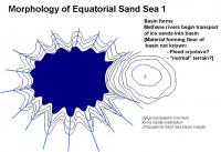
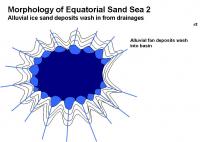
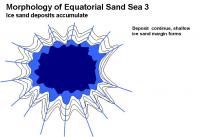
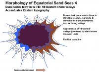
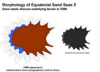
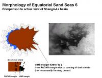
Ive put together a sequence of events that could explain the morphology of the Equatorial Sand Seas. (An example basin similar to Shangri-La is shown)
This could explain the ria-like topography [http://en.wikipedia.org/wiki/Ria] on the Eastern shore, as well as the VIMS dark blue western parts of the Sand seas, and the placement of the dark brown unit on the Eastern parts of the sand seas. 1. Basin formation. 2. Water-ice sand deposition [slowly, suddenly?] forms an ice-sand margin 3. Mobile dark brown dune sands deposit on E side, depositing inland up W facing valleys.
:attachment] The dark brown sands will blow in following the predominantly W winds and make a dust coating on low-lying terrains on the eastern margins. This will be visible by VIMS and ISS as the dark-bright margin, placed inland from the "real margin" and will accentuate the local topography as seen by optical instruments. This accentuation on the E margin will make the Equatorial Sand Sea visible margin look swoopy and windblown (in effect, it is) from the dark basin. Similarly, the W margin will have a dark blue zone that appears blown from the western bright areas. On the Eastern shore, the RADAR images will place the smooth-dark/mottled gray boundary far to the W of the VIMS brown dark-bright margin. (RADAR should be able to penetrate a thin coating of dark sands). The features in the limbo zone have been covered by dark sands, perhaps not enough to form dune structures, but enough to cover up the ice-sand margin, the near shore terrain, and perhaps even some of the underlying bright terrain. This makes the deposition sequence in the Equatorial Sand Seas: 1: Basin formation 2. Major water ice sand emplacement 3. Dune sands cover up low-lying downwind valleys (enough to mask visible imagery) Other Equatorial Sand Sea basins should look very similar around Titan: Shangri-La, Belet, Senkyo, Fensal and Quivra. Local winds may play a bonus role, but the overall trend of dark sand deposition up valley should be towards the E. For example: the false-color image in Figure 6 of the Soderblom paper seems to imply a predominant wind vector in Fensal and Quivra to the ESE. [Im pretty sure all this has been described in pieces before, but it gave me a really great excuse to play with PowerPoint.  ] ]-Mike
Attached thumbnail(s)
-------------------- Some higher resolution images available at my photostream: http://www.flickr.com/photos/31678681@N07/
|
||||||
 |
 
|
||||||
 |
|
May 24 2007, 01:00 AM
Post
#2
|
|
 Senior Member Group: Members Posts: 1887 Joined: 20-November 04 From: Iowa Member No.: 110 |
Would the strength of these tides tides vary with latitude? If so I can see this as an additional reason for the lakes being concentrted at the poles. Stronger tides at low latitudes could result in liquid filled basins being enlarged by tidal motion. Eventually they could reach the point where increased evaporation or seepage caused them to dry up.
|
|
|
|
|
May 26 2007, 01:29 PM
Post
#3
|
|
 Member Group: Members Posts: 613 Joined: 23-February 07 From: Occasionally in Columbia, MD Member No.: 1764 |
QUOTE (alan @ May 23 2007, 09:00 PM)  Would the strength of these tides tides vary with latitude? If so I can see this as an additional reason for the lakes being concentrted at the poles. Stronger tides at low latitudes could result in liquid filled basins being enlarged by tidal motion. Eventually they could reach the point where increased evaporation or seepage caused them to dry up. Yes - the strength varies with latitude (and longitude) - specifically with distance from the subsaturn point. A brief intro to tides on Titan and their effect on lakes (from 1993 - it includes some predicted landforms that, er, well, havent been borne out by observations so far, let's say - but it lays out some useful fundamentals) is at http://www.lpl.arizona.edu/~rlorenz/craterlakes.pdf Tides are generally weaker at high latitudes. I dont think tides explains why we find liquids where we do (but they may be responsible for the lack of wave-type features on shorelines like sandbars - tidal displacement of the waterline is larger than typical waveheight..) |
|
|
|
|
Jun 4 2007, 04:31 PM
Post
#4
|
||||||||
|
Senior Member Group: Moderator Posts: 2785 Joined: 10-November 06 From: Pasadena, CA Member No.: 1345 |
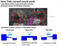
QUOTE (rlorenz @ May 26 2007, 09:29 AM) A brief intro to tides on Titan and their effect on lakes (...) is at http://www.lpl.arizona.edu/~rlorenz/craterlakes.pdf I attempted to relate the tide effects mentioned above and in other (papers you gotta pay for) to the Channel in W Belet. Here are the non-free references: Sagan and Dermott Nature 1982, 300, 731-733. "The tide in the seas of Titan". Dermott and Sagan Nature 1995, 374, 238-240. "Tidal effects of disconnected hydrocarbon seas on Titan". Tokano and Neubauer Icarus 2002, 158-499-515. "Tidal Winds on Titan Caused by Saturn." The figures attached describe the tidal effects of tidally locked planet with significant orbital eccentricity and a global ocean. (e.g. Titan, but with a global ocean):
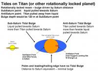
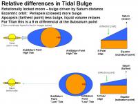
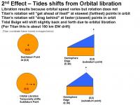
The tidal bulge is set by the gravitational attraction by the influencing body (e.g. Saturn on Titan). At the sub-Saturn point, Saturn pulls on the hydrocarbon ocean since the ocean is closer to Saturn than the core of Titan. (Think of it as Saturn trying to accelerate the ocean away from Titan). At the anti-Saturn point, Saturn pulls on the core of Titan more than the hydrocarbon carbon ocean which is further from Saturn. (Think of it as Saturn trying to accelerate Titan away from the ocean.) At the poles and hemisphere edges, the ocean is at the same relative distance from Saturn and the core of Titan, so there is no bulge at these locations. (For more info, check out: http://en.wikipedia.org/wiki/Tidal_bulge http://home.hiwaay.net/~krcool/Astro/moon/moontides/ ) Since Titan is tidally locked, and the same point (more or less) faces Saturn, the tidal bulge is pretty much frozen in place. From Sagan et al. the tidal bulge of a theoretical global hydrocarbon ocean on Titan would be 120 m higher at the sub-Saturn point and at the anti-Saturn point. The tide is set by the relative height differential of the tidal bulge. If Titans orbit were perfectly circular, there would be no difference and the sub-Saturn point tidal bulge would always be at 120 m. So no differential, thus no tide. But Titan has an eccentric orbit. (e = 0.0289). When Saturn is closer to Titan, the tidal bulges are more accentuated than when it is farther away. This is by 9% (3e = 3 x 0.0289), or 9 m higher at the sub-Saturn point. When Saturn is farther away, the bulge is lower by 9 m. But since the liquid volume is fixed, the excess mass gets distributed to the remainder of the ocean. So the ocean height at the hemisphere edge increases (slightly all that 9 m of bulge differential is distributing over a much, much larger area). This increase would be the local high tide at the periphery of the hemisphere and poles. There will also be a point of inflection that would not experience any tidal differential. In addition, there is a slight effect due to orbital libration. This causes a drift along the equator of 150 km of the tidal bulge of the sub-Saturn (and thus anti-Saturn) points. This would result from the rotation of Titan being fixed but the orbital speed is variable. At it reaches periapsis, Titan is zipping along and the rotation will be dragging behind. As it whips around the periapsis point, the rotation is still slower so the Tidal bulge will appear to move forward. The net effect will be to ratchet the Tidal Bulge forward (eastward) a small amount. There would be a similar drift westward at the far end of the orbit for the same reason, but the effect will be much smaller (since the bulge will be smaller at apoapsis). This will also smear the Tidal Bulge along the EW direction.
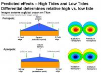
Combining these effects we get a theoretical picture of the global ocean height at periapsis (closest to Saturn) and apoapsis (farthest from Saturn). The sub-Saturn and anti-Saturn point will have the largest effect (9 m!). The poles and hemisphere edges will have a much smaller effect (<9 m) and there will be zone of inflection with no differential is shown in green. This model is assuming a global ocean. On Titan, it appears that there were multiple shallow sea basins that were flooded during the last major inundation. That means that any relaxation of tidal volume from a bulge at one end of a sea would need to be taken up at the other end of the sea. For example, the Anti-Saturn point is at the W end of Shangri-La basin; as Titans orbit swings farther from Saturn, the liquid under the tidal bulge would be somewhat redistributed to the farther parts of the Shangri-La basin (and would also try to redistribute to other connected basins, such as Ching-Tu and Belet). From the logic above, the best places to look for tidal channels would be nearest the sub-Saturn and anti-Saturn points in the narrow constrictions between basins or archipeligos.
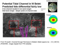
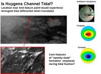
In the Anti-Saturn hemisphere, the dark areas between Dilmun and Adiri (the channel between Shangri-La and Belet) should be a really good place to look for tidal channels (sliced carrot feature?). Another place would be the passages connecting Shangri-La and Ching Tu, as well as Ching-Tu and Belet. (Is the Huygens channel a former tidal channel? Its location fits nicely with predicted tidal differentials!) . In the Sub-Saturn hemisphere, narrow channels between Aztlan and Aaru, narrow channels between Aztlan and Fensal (extreme E Quivra) and Senkyo/Fensal and Aaru/Senkyo would be interesting to check out. The areas between Senkyo and Belet may be also of some interest. The possible Tidal channel in W Belet is located in an area that may not have the largest possible tidal differential. (But heck, the potential Earth analog, Deception Pass, gets an impressive flush from only a 1.5 m tide height differential.) The poles should have almost zero tides, especially if they are/were disconnected from any bodies of liquid involved in the SubSaturn or AntiSaturn Tidal Bulges. Other effects that may influence tidal flushes include both sea bottom topography and tidal resonances. -Mike -------------------- Some higher resolution images available at my photostream: http://www.flickr.com/photos/31678681@N07/
|
|||||||
|
|
|
|||||||
 Juramike Titan's Equatorial Sand Seas May 7 2007, 03:53 PM
 Juramike Ive put together another hypothetical series of e... May 8 2007, 11:44 PM
 volcanopele QUOTE (Juramike @ May 8 2007, 04:44 PM) I... May 10 2007, 07:15 PM ngunn Just in case you're wondering Mike I'm fol... May 9 2007, 02:39 PM Juramike QUOTE (ngunn @ May 9 2007, 10:39 AM) Also... May 9 2007, 05:35 PM Littlebit QUOTE (ngunn @ May 9 2007, 08:39 AM) Just... May 9 2007, 05:55 PM Juramike Here is an example of a smaller isolated Dune Sea.... May 11 2007, 10:08 PM remcook I think a massive rain storm around the equator mi... May 9 2007, 02:51 PM Juramike There are a few examples of both RADAR dark and RA... May 10 2007, 11:00 PM ngunn QUOTE (Juramike @ May 11 2007, 12:00 AM) ... May 11 2007, 07:04 PM Juramike QUOTE (ngunn @ May 11 2007, 03:04 PM) Nic... May 11 2007, 07:34 PM rlorenz QUOTE (Juramike @ May 11 2007, 03:34 PM) ... May 12 2007, 03:40 PM ngunn [quote name='rlorenz' date='May 12 200... May 12 2007, 08:01 PM Juramike Here are some images and locations where dunes hav... May 11 2007, 09:46 PM lyford Thanks for all the awesomeness, Juramike May 12 2007, 03:10 AM ngunn Mike, in your first illustration in post 11 (for e... May 12 2007, 07:35 PM Matt I stumbled a publication (PDF) entitled: 'Com... May 13 2007, 09:23 PM Matt I stumbled upon a publication, rather. May 13 2007, 09:28 PM Mongo ^link?
Bill May 13 2007, 10:28 PM Matt http://www.lpi.usra.edu/meetings/lpsc2007/pdf/2222... May 13 2007, 11:00 PM Juramike Ive put together a hypothetical sequence that cou... May 14 2007, 03:00 PM Exploitcorporations This seems like as good a place as any to deposit ... May 14 2007, 06:30 PM Juramike Wow! Thank you, Exploitcorporations!
(Lo... May 14 2007, 06:40 PM volcanopele QUOTE (Juramike @ May 14 2007, 11:40 AM) ... May 14 2007, 07:44 PM Juramike QUOTE (volcanopele @ May 14 2007, 03:44 P... May 14 2007, 09:15 PM remcook simply...wow! amazing how sharp it is! May 14 2007, 07:06 PM Juramike QUOTE (rlorenz @ May 12 2007, 11:40 AM) W... May 14 2007, 08:22 PM volcanopele hmm, I suspect that the feature you thought was Ks... May 14 2007, 09:29 PM Juramike Are there easy ways to discern between a cryovolca... May 14 2007, 09:40 PM volcanopele Well, it would be nice if it erupted. That would ... May 14 2007, 09:56 PM Juramike Hmmm. Actually, there might be a way to see a rec... May 17 2007, 06:43 PM Exploitcorporations Here's another work in progress. This makeover... May 18 2007, 01:35 AM Phil Stooke Very nice. I hope you will do more of these.
Phi... May 18 2007, 01:48 AM belleraphon1 Exploitcorporations
All your work is breathtaking... May 18 2007, 02:09 AM Juramike Wow!! That is totally awesome!!... May 18 2007, 03:28 PM Juramike One of the dark channels from the T8 RADAR swath ... May 21 2007, 08:06 PM helvick Surely Titan's Saturn synchronous orbit would ... May 21 2007, 08:19 PM Juramike QUOTE (helvick @ May 21 2007, 04:19 PM) S... May 21 2007, 08:34 PM alan I remember reading a paper before Cassini reached ... May 22 2007, 01:04 AM AlexBlackwell QUOTE (alan @ May 21 2007, 03:04 PM) I re... May 22 2007, 01:44 AM Mongo If Titan had global oceans on its surface, its tid... May 22 2007, 01:42 AM ngunn We have a beautiful example of a tidal channel her... May 22 2007, 09:28 AM ngunn Menai Strait chart attached:
Note that this is q... May 22 2007, 12:17 PM Juramike (I sooooo totally could not resist this...)
Furt... May 22 2007, 02:24 PM ngunn If we are saying that the equatorial basins once c... May 22 2007, 04:33 PM Juramike QUOTE (ngunn @ May 22 2007, 12:33 PM) If ... May 22 2007, 06:02 PM David Are the sand basins really very far below the surr... May 22 2007, 07:10 PM Juramike QUOTE (David @ May 22 2007, 03:10 PM) Are... May 23 2007, 02:28 PM ngunn Another question, Mike. I'm looking at the ... May 23 2007, 02:53 PM Littlebit Excellant theory, Mike. If the sand dunes are stil... May 23 2007, 03:16 PM Juramike Ngunn, it fits pretty close.
I suspect that there... May 23 2007, 03:23 PM ngunn I certainly find these ideas plausible - and now y... May 23 2007, 03:50 PM ngunn QUOTE (Juramike @ Jun 4 2007, 05:31 PM) F... Jun 5 2007, 10:32 AM Juramike QUOTE (ngunn @ Jun 5 2007, 06:32 AM) Are ... Jun 5 2007, 04:34 PM ngunn QUOTE (Juramike @ Jun 4 2007, 05:31 PM) I... Jun 5 2007, 11:12 AM Juramike QUOTE (ngunn @ Jun 5 2007, 07:12 AM) I... Jun 5 2007, 05:52 PM ngunn QUOTE (Juramike @ Jun 5 2007, 06:52 PM) b... Jun 5 2007, 08:12 PM Juramike QUOTE (ngunn @ Jun 5 2007, 04:12 PM) The ... Jun 5 2007, 09:10 PM ngunn QUOTE (Juramike @ Jun 5 2007, 10:10 PM) H... Jun 6 2007, 10:07 AM Juramike I used the published altimetry data to try and est... May 29 2007, 04:33 PM JRehling QUOTE (Juramike @ May 29 2007, 09:33 AM) ... May 29 2007, 05:10 PM Juramike I used the "ski tracks" feature in the T... May 29 2007, 06:18 PM Stu Fascinating reading as always Juramike, thanks. Yo... May 29 2007, 06:45 PM Juramike My WAG about the "dancing monkey" or ... May 29 2007, 07:17 PM ngunn Well, one striking characteristic of the 'hood... Jun 5 2007, 06:07 PM Juramike That's a really good point on the clean-lookin... Jun 5 2007, 07:46 PM Juramike Following the calculations in the Sagan, Dermott, ... Jun 5 2007, 10:07 PM Juramike Does anyone have an idea what the heck these are? ... Jun 5 2007, 10:18 PM ngunn QUOTE (Juramike @ Jun 5 2007, 11:18 PM) D... Jun 6 2007, 02:47 PM ngunn A further thought - two plausible eruption product... Jun 6 2007, 12:02 PM Juramike Cryopumice is a very interesting concept. Those t... Jun 6 2007, 05:36 PM volcanopele QUOTE (Juramike @ Jun 6 2007, 10:36 AM) W... Jun 6 2007, 06:35 PM Juramike QUOTE (volcanopele @ Jun 6 2007, 02:35 PM... Jun 6 2007, 09:16 PM volcanopele I think such a feature might have been seen in nor... Jun 6 2007, 09:47 PM Juramike Cool-o! Was that by RADAR or VIMS?
Got coord... Jun 6 2007, 09:49 PM volcanopele You know, ISS does take images of Titan too... ... Jun 6 2007, 10:20 PM Juramike QUOTE (volcanopele @ Jun 6 2007, 06:20 PM... Jun 6 2007, 10:46 PM Juramike Here is an image of the feature (multi-ring Minrva... Jun 6 2007, 10:57 PM volcanopele Yeah, I just don't see how that is similar to ... Jun 6 2007, 11:21 PM Juramike I was taking the analogy of it looking like it had... Jun 6 2007, 11:59 PM volcanopele Now that feature in Aaru reminds me of Menrva, wit... Jun 7 2007, 12:11 AM Juramike I've put together a list and maps of speculati... Jun 7 2007, 12:36 AM volcanopele The problem is that most of those are oblong featu... Jun 7 2007, 12:56 AM Juramike Yup. I think you're right. Most the features... Jun 7 2007, 01:07 AM ngunn Where do you find the time, Mike???? Anyhow thanks... Jun 7 2007, 09:40 AM Juramike QUOTE (ngunn @ Jun 7 2007, 05:40 AM) Wher... Jun 7 2007, 06:50 PM Juramike Approximately 60% (30 out of 50) of the circular/... Jun 14 2007, 02:49 PM Juramike Here is a short list of possible suspects for the ... Jun 14 2007, 07:23 PM ngunn QUOTE (Juramike @ Jun 14 2007, 08:23 PM) ... Jun 15 2007, 09:28 AM Juramike QUOTE (ngunn @ Jun 15 2007, 05:28 AM) I h... Jun 15 2007, 06:24 PM Juramike From the circular features EXCEL table above, I ... Jun 15 2007, 11:18 PM Juramike I plotted the outer/inner diameter measurements of... Jun 20 2007, 01:57 AM ngunn Juramike I salute your work, but sadly I doubt if ... Jun 20 2007, 09:42 PM Juramike QUOTE (ngunn @ Jun 20 2007, 05:42 PM) Phi... Jun 21 2007, 03:15 PM dvandorn QUOTE (Juramike @ Jun 21 2007, 10:15 AM) ... Jun 21 2007, 03:36 PM ngunn Ganymede et.al.
Undoubtedly we can look to the Gal... Jun 20 2007, 10:02 PM Juramike QUOTE (ngunn @ Jun 20 2007, 06:02 PM) Gan... Jun 21 2007, 04:04 PM
volcanopele QUOTE (Juramike @ May 8 2007, 04:44 PM) I... May 10 2007, 07:15 PM ngunn Just in case you're wondering Mike I'm fol... May 9 2007, 02:39 PM Juramike QUOTE (ngunn @ May 9 2007, 10:39 AM) Also... May 9 2007, 05:35 PM Littlebit QUOTE (ngunn @ May 9 2007, 08:39 AM) Just... May 9 2007, 05:55 PM Juramike Here is an example of a smaller isolated Dune Sea.... May 11 2007, 10:08 PM remcook I think a massive rain storm around the equator mi... May 9 2007, 02:51 PM Juramike There are a few examples of both RADAR dark and RA... May 10 2007, 11:00 PM ngunn QUOTE (Juramike @ May 11 2007, 12:00 AM) ... May 11 2007, 07:04 PM Juramike QUOTE (ngunn @ May 11 2007, 03:04 PM) Nic... May 11 2007, 07:34 PM rlorenz QUOTE (Juramike @ May 11 2007, 03:34 PM) ... May 12 2007, 03:40 PM ngunn [quote name='rlorenz' date='May 12 200... May 12 2007, 08:01 PM Juramike Here are some images and locations where dunes hav... May 11 2007, 09:46 PM lyford Thanks for all the awesomeness, Juramike May 12 2007, 03:10 AM ngunn Mike, in your first illustration in post 11 (for e... May 12 2007, 07:35 PM Matt I stumbled a publication (PDF) entitled: 'Com... May 13 2007, 09:23 PM Matt I stumbled upon a publication, rather. May 13 2007, 09:28 PM Mongo ^link?
Bill May 13 2007, 10:28 PM Matt http://www.lpi.usra.edu/meetings/lpsc2007/pdf/2222... May 13 2007, 11:00 PM Juramike Ive put together a hypothetical sequence that cou... May 14 2007, 03:00 PM Exploitcorporations This seems like as good a place as any to deposit ... May 14 2007, 06:30 PM Juramike Wow! Thank you, Exploitcorporations!
(Lo... May 14 2007, 06:40 PM volcanopele QUOTE (Juramike @ May 14 2007, 11:40 AM) ... May 14 2007, 07:44 PM Juramike QUOTE (volcanopele @ May 14 2007, 03:44 P... May 14 2007, 09:15 PM remcook simply...wow! amazing how sharp it is! May 14 2007, 07:06 PM Juramike QUOTE (rlorenz @ May 12 2007, 11:40 AM) W... May 14 2007, 08:22 PM volcanopele hmm, I suspect that the feature you thought was Ks... May 14 2007, 09:29 PM Juramike Are there easy ways to discern between a cryovolca... May 14 2007, 09:40 PM volcanopele Well, it would be nice if it erupted. That would ... May 14 2007, 09:56 PM Juramike Hmmm. Actually, there might be a way to see a rec... May 17 2007, 06:43 PM Exploitcorporations Here's another work in progress. This makeover... May 18 2007, 01:35 AM Phil Stooke Very nice. I hope you will do more of these.
Phi... May 18 2007, 01:48 AM belleraphon1 Exploitcorporations
All your work is breathtaking... May 18 2007, 02:09 AM Juramike Wow!! That is totally awesome!!... May 18 2007, 03:28 PM Juramike One of the dark channels from the T8 RADAR swath ... May 21 2007, 08:06 PM helvick Surely Titan's Saturn synchronous orbit would ... May 21 2007, 08:19 PM Juramike QUOTE (helvick @ May 21 2007, 04:19 PM) S... May 21 2007, 08:34 PM alan I remember reading a paper before Cassini reached ... May 22 2007, 01:04 AM AlexBlackwell QUOTE (alan @ May 21 2007, 03:04 PM) I re... May 22 2007, 01:44 AM Mongo If Titan had global oceans on its surface, its tid... May 22 2007, 01:42 AM ngunn We have a beautiful example of a tidal channel her... May 22 2007, 09:28 AM ngunn Menai Strait chart attached:
Note that this is q... May 22 2007, 12:17 PM Juramike (I sooooo totally could not resist this...)
Furt... May 22 2007, 02:24 PM ngunn If we are saying that the equatorial basins once c... May 22 2007, 04:33 PM Juramike QUOTE (ngunn @ May 22 2007, 12:33 PM) If ... May 22 2007, 06:02 PM David Are the sand basins really very far below the surr... May 22 2007, 07:10 PM Juramike QUOTE (David @ May 22 2007, 03:10 PM) Are... May 23 2007, 02:28 PM ngunn Another question, Mike. I'm looking at the ... May 23 2007, 02:53 PM Littlebit Excellant theory, Mike. If the sand dunes are stil... May 23 2007, 03:16 PM Juramike Ngunn, it fits pretty close.
I suspect that there... May 23 2007, 03:23 PM ngunn I certainly find these ideas plausible - and now y... May 23 2007, 03:50 PM ngunn QUOTE (Juramike @ Jun 4 2007, 05:31 PM) F... Jun 5 2007, 10:32 AM Juramike QUOTE (ngunn @ Jun 5 2007, 06:32 AM) Are ... Jun 5 2007, 04:34 PM ngunn QUOTE (Juramike @ Jun 4 2007, 05:31 PM) I... Jun 5 2007, 11:12 AM Juramike QUOTE (ngunn @ Jun 5 2007, 07:12 AM) I... Jun 5 2007, 05:52 PM ngunn QUOTE (Juramike @ Jun 5 2007, 06:52 PM) b... Jun 5 2007, 08:12 PM Juramike QUOTE (ngunn @ Jun 5 2007, 04:12 PM) The ... Jun 5 2007, 09:10 PM ngunn QUOTE (Juramike @ Jun 5 2007, 10:10 PM) H... Jun 6 2007, 10:07 AM Juramike I used the published altimetry data to try and est... May 29 2007, 04:33 PM JRehling QUOTE (Juramike @ May 29 2007, 09:33 AM) ... May 29 2007, 05:10 PM Juramike I used the "ski tracks" feature in the T... May 29 2007, 06:18 PM Stu Fascinating reading as always Juramike, thanks. Yo... May 29 2007, 06:45 PM Juramike My WAG about the "dancing monkey" or ... May 29 2007, 07:17 PM ngunn Well, one striking characteristic of the 'hood... Jun 5 2007, 06:07 PM Juramike That's a really good point on the clean-lookin... Jun 5 2007, 07:46 PM Juramike Following the calculations in the Sagan, Dermott, ... Jun 5 2007, 10:07 PM Juramike Does anyone have an idea what the heck these are? ... Jun 5 2007, 10:18 PM ngunn QUOTE (Juramike @ Jun 5 2007, 11:18 PM) D... Jun 6 2007, 02:47 PM ngunn A further thought - two plausible eruption product... Jun 6 2007, 12:02 PM Juramike Cryopumice is a very interesting concept. Those t... Jun 6 2007, 05:36 PM volcanopele QUOTE (Juramike @ Jun 6 2007, 10:36 AM) W... Jun 6 2007, 06:35 PM Juramike QUOTE (volcanopele @ Jun 6 2007, 02:35 PM... Jun 6 2007, 09:16 PM volcanopele I think such a feature might have been seen in nor... Jun 6 2007, 09:47 PM Juramike Cool-o! Was that by RADAR or VIMS?
Got coord... Jun 6 2007, 09:49 PM volcanopele You know, ISS does take images of Titan too... ... Jun 6 2007, 10:20 PM Juramike QUOTE (volcanopele @ Jun 6 2007, 06:20 PM... Jun 6 2007, 10:46 PM Juramike Here is an image of the feature (multi-ring Minrva... Jun 6 2007, 10:57 PM volcanopele Yeah, I just don't see how that is similar to ... Jun 6 2007, 11:21 PM Juramike I was taking the analogy of it looking like it had... Jun 6 2007, 11:59 PM volcanopele Now that feature in Aaru reminds me of Menrva, wit... Jun 7 2007, 12:11 AM Juramike I've put together a list and maps of speculati... Jun 7 2007, 12:36 AM volcanopele The problem is that most of those are oblong featu... Jun 7 2007, 12:56 AM Juramike Yup. I think you're right. Most the features... Jun 7 2007, 01:07 AM ngunn Where do you find the time, Mike???? Anyhow thanks... Jun 7 2007, 09:40 AM Juramike QUOTE (ngunn @ Jun 7 2007, 05:40 AM) Wher... Jun 7 2007, 06:50 PM Juramike Approximately 60% (30 out of 50) of the circular/... Jun 14 2007, 02:49 PM Juramike Here is a short list of possible suspects for the ... Jun 14 2007, 07:23 PM ngunn QUOTE (Juramike @ Jun 14 2007, 08:23 PM) ... Jun 15 2007, 09:28 AM Juramike QUOTE (ngunn @ Jun 15 2007, 05:28 AM) I h... Jun 15 2007, 06:24 PM Juramike From the circular features EXCEL table above, I ... Jun 15 2007, 11:18 PM Juramike I plotted the outer/inner diameter measurements of... Jun 20 2007, 01:57 AM ngunn Juramike I salute your work, but sadly I doubt if ... Jun 20 2007, 09:42 PM Juramike QUOTE (ngunn @ Jun 20 2007, 05:42 PM) Phi... Jun 21 2007, 03:15 PM dvandorn QUOTE (Juramike @ Jun 21 2007, 10:15 AM) ... Jun 21 2007, 03:36 PM ngunn Ganymede et.al.
Undoubtedly we can look to the Gal... Jun 20 2007, 10:02 PM Juramike QUOTE (ngunn @ Jun 20 2007, 06:02 PM) Gan... Jun 21 2007, 04:04 PM |

|
Lo-Fi Version | Time is now: 26th September 2024 - 09:15 AM |
|
RULES AND GUIDELINES Please read the Forum Rules and Guidelines before posting. IMAGE COPYRIGHT |
OPINIONS AND MODERATION Opinions expressed on UnmannedSpaceflight.com are those of the individual posters and do not necessarily reflect the opinions of UnmannedSpaceflight.com or The Planetary Society. The all-volunteer UnmannedSpaceflight.com moderation team is wholly independent of The Planetary Society. The Planetary Society has no influence over decisions made by the UnmannedSpaceflight.com moderators. |
SUPPORT THE FORUM Unmannedspaceflight.com is funded by the Planetary Society. Please consider supporting our work and many other projects by donating to the Society or becoming a member. |
|