Reprocessing Historical Images, Looking for REALLY big challenges? |

Reprocessing Historical Images, Looking for REALLY big challenges? |
 Apr 21 2005, 11:26 PM Apr 21 2005, 11:26 PM
Post
#1
|
|
|
Member  Group: Members Posts: 123 Joined: 21-February 05 Member No.: 175 |
.
|
 |
 
|
 |
|
Apr 23 2005, 09:25 AM
Post
#2
|
|
|
Senior Member Group: Members Posts: 1870 Joined: 20-February 05 Member No.: 174 |
The digital data for the final versions of <most?> of the Mariner 4 mars images are available in many university engineering or aerospace department libraries. *** IN PAPER COPY! *** The Mariner Mars 1964 Project Report <in multiple volumes> contained a volume entitled something like "picture element matricies", which contained PRINTOUTS of the 200 lines and 200 samples of 6 bit data for each processed image.
I've wanted for years to scan and OCR the data and make digital versions of the images, but ..... time and effort ..... Note that the mariner 4 images were taken in alternating red and green filters, with every third image not recorded. So the pictures are: green, red, missing, red, green, missing, green, red, missing etc. The corner of one image of each red/green pair OVERLAPPED by about 100 pixels, so there is some color data from the Mariner 4 images. All that was done for the final project report was not entirely accurate registration of the overlapping image segments and either differencing or ratioing of the images to separate color differences from brightness differences. Nothing was published in any form as a color picture from that data to my knowledge. |
|
|
|
|
Apr 25 2005, 11:29 PM
Post
#3
|
|||
|
Member Group: Members Posts: 378 Joined: 21-April 05 From: Portugal Member No.: 347 |
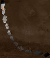
QUOTE ... Note that the mariner 4 images were taken in alternating red and green filters, with every third image not recorded. So the pictures are: green, red, missing, red, green, missing, green, red, missing etc. The corner of one image of each red/green pair OVERLAPPED by about 100 pixels, so there is some color data from the Mariner 4 images. .... With this information I processed the scanned Mariner 4 images avaliable here http://nssdc.gsfc.nasa.gov/imgcat/html/mis...er_4_page1.html using the gray scale bars to "normalize" the images and resampling them to 200x200 pixels. Then I made mosaics from the image pairs and put them in a map by matching the visible surface features. I also used the overlaping Red / Green areas to generate a small color area inside the mosaics. I'm ataching a map with all the images and a mosaic. All this will be avaliable in my page soon!
-------------------- _______________________
www.astrosurf.com/nunes |
||
|
|
|
||
 GregM Reprocessing Historical Images Apr 21 2005, 11:26 PM
 Gsnorgathon I have to admit I'm a real sucker for those ... Apr 22 2005, 08:05 AM OWW Cool Mariner 4/6/7 ( and more ) stuff:
http://memb... Apr 22 2005, 08:16 AM 4th rock from the sun The problem is having the original datasets for th... Apr 22 2005, 12:14 PM
Gsnorgathon I have to admit I'm a real sucker for those ... Apr 22 2005, 08:05 AM OWW Cool Mariner 4/6/7 ( and more ) stuff:
http://memb... Apr 22 2005, 08:16 AM 4th rock from the sun The problem is having the original datasets for th... Apr 22 2005, 12:14 PM
 GregM . Apr 22 2005, 04:01 PM tedstryk Don Mitchell has gotten ahold of the original Vene... Apr 22 2005, 04:24 PM gpurcell QUOTE (GregM @ Apr 22 2005, 04:01 PM)QUOTE (4... Apr 22 2005, 06:55 PM tedstryk In the case of the Venera data, that is a Russian ... Apr 22 2005, 08:02 PM deglr6328 QUOTE (tedstryk @ Apr 22 2005, 08:02 PM)In th... Apr 22 2005, 11:56 PM tedstryk I have not come across original Pioneer image data... Apr 23 2005, 03:04 AM GregM . Apr 23 2005, 04:28 AM edstrick Mariner 6 and 7 returned two "primary" i... Apr 23 2005, 09:50 AM tedstryk The reason so much of Mariner 6/7 imagery was sent... Apr 23 2005, 12:24 PM Bob Shaw Somewhere in my box of space slides from the 1970s... Apr 23 2005, 12:37 PM tedstryk QUOTE (Bob Shaw @ Apr 23 2005, 12:37 PM)Somew... Apr 23 2005, 12:49 PM Bob Shaw Yup, that's the chappie!
And my memory is... Apr 23 2005, 09:13 PM peter59 QUOTE (edstrick @ Apr 23 2005, 09:50 AM)Marin... Apr 24 2005, 06:39 AM edstrick Mariner Mars 1971 was to be a two spacecraft missi... Apr 23 2005, 10:14 AM deglr6328 I am so consistently dumbfounded at the amazing de... Apr 23 2005, 05:50 PM edstrick To chase down the history and existance of the Pio... Apr 23 2005, 08:28 PM tedstryk QUOTE (edstrick @ Apr 23 2005, 08:28 PM)To ch... Apr 24 2005, 03:08 AM TheChemist peter59,
thanks for providing the link to your won... Apr 24 2005, 08:24 AM edstrick One annoying problem with the radiometrically corr... Apr 24 2005, 09:39 AM GregM . Apr 27 2005, 01:55 AM edstrick GregM and 4'th Rock are certainly on the right... Apr 27 2005, 10:49 AM tedstryk Speaking of historical images, this is some work I... May 9 2005, 04:16 AM Phil Stooke It's show and tell time.. I guess. Here's... May 11 2005, 03:32 AM Bjorn Jonsson This is extremely impressive, IMHO especially pete... May 12 2005, 10:57 PM tedstryk QUOTE (Bjorn Jonsson @ May 12 2005, 10:57 PM)... May 14 2005, 09:42 PM GregM . May 17 2005, 03:27 AM dvandorn QUOTE (GregM @ May 16 2005, 10:27 PM)<snip... May 17 2005, 06:29 AM JRehling QUOTE (GregM @ May 16 2005, 08:27 PM)That... May 17 2005, 03:24 PM Phil Stooke I promised earlier that I would post something fro... May 17 2005, 01:26 PM tedstryk Phil, I am nowhere near trumping you. It will be ... May 17 2005, 07:38 PM Bob Shaw Phil:
Very, very nice!
Now, the $64,000... May 17 2005, 07:39 PM dvandorn QUOTE (Bob Shaw @ May 17 2005, 02:39 PM)Phil:... May 17 2005, 08:01 PM dvandorn QUOTE (Phil Stooke @ May 17 2005, 08:26 AM)I ... May 17 2005, 07:41 PM BruceMoomaw If I remember correctly, Voyager 2 also got some b... May 17 2005, 06:32 PM Phil Stooke The detail looks west and north, and the full pan ... May 17 2005, 08:05 PM Bob Shaw Thanks, guys! May 17 2005, 09:02 PM tedstryk QUOTE (Phil Stooke @ May 17 2005, 08:05 PM)Th... May 17 2005, 11:27 PM Phil Stooke I am attaching a set of maps which portray the Sur... May 18 2005, 01:37 PM chris Very nice, Phil.
Chris May 18 2005, 02:41 PM Bob Shaw Fascinating! May 18 2005, 08:43 PM tedstryk QUOTE (Bob Shaw @ May 18 2005, 08:43 PM)Fasci... May 22 2005, 07:49 PM Bjorn Jonsson QUOTE (tedstryk @ May 22 2005, 07:49 PM)Does ... May 22 2005, 11:23 PM tedstryk
If you have these numbers in a simple text file I... May 23 2005, 12:06 AM GregM . May 23 2005, 02:16 AM Phil Stooke I didn't do the geometric correction!
T... May 23 2005, 03:09 AM Bob Shaw The Surveyor hemispherical panorama domes (there *... May 23 2005, 10:23 AM edstrick A number of postings back, somebody was "diss... May 23 2005, 04:58 AM dvandorn QUOTE (edstrick @ May 22 2005, 11:58 PM)A num... May 23 2005, 06:44 AM edstrick I don't know any links, the Pioneer team never... May 23 2005, 09:49 AM lyford QUOTE (edstrick @ May 23 2005, 01:49 AM)I don... May 23 2005, 03:48 PM Bjorn Jonsson I made a preliminary page containing several Pione... May 23 2005, 08:26 PM 4th rock from the sun QUOTE (lyford @ May 23 2005, 04:48 PM)That bo... May 23 2005, 09:41 PM Phil Stooke A few more words about the Surveyor panoramas. Th... May 23 2005, 10:07 PM dvandorn QUOTE (Phil Stooke @ May 23 2005, 05:07 PM)A ... May 24 2005, 06:58 AM edstrick The Surveyor images were recorded on tape... ANALO... May 24 2005, 10:55 AM tedstryk QUOTE (edstrick @ May 24 2005, 10:55 AM)The S... May 24 2005, 11:45 AM djellison Shouldnt someone like the Planetary Society or sim... May 24 2005, 11:38 AM Phil Stooke Ted said:
Actually, that project is still underwa... May 24 2005, 01:12 PM Phil Stooke ...And I ought to add something about Russian effo... May 24 2005, 01:24 PM tedstryk Yeah, Voyager was the last to have the dots. Vidi... May 24 2005, 02:08 PM Decepticon In the Pionner images of Jupiters moons Ganymede l... May 25 2005, 07:24 PM tedstryk QUOTE (Decepticon @ May 25 2005, 07:24 PM)In ... May 25 2005, 08:03 PM Decepticon Great work! ^ May 25 2005, 09:14 PM Decepticon If remember right, one of the Pionners was to take... May 26 2005, 12:39 AM tedstryk QUOTE (Decepticon @ May 26 2005, 12:39 AM)I r... May 26 2005, 12:57 AM edstrick The Pioneer Jupiter missions were done by direct c... May 26 2005, 08:07 AM Decepticon What a shock it would have been if those images ma... May 26 2005, 01:21 PM tedstryk Another project I am working on is trying to work ... May 27 2005, 02:01 PM chris The thing that always amazes me about the Venera l... May 27 2005, 03:10 PM Bob Shaw The estimable Don Davis has also rectified Venera ... May 27 2005, 04:04 PM tedstryk QUOTE (Bob Shaw @ May 27 2005, 04:04 PM)The e... May 27 2005, 04:39 PM JRehling QUOTE (tedstryk @ May 27 2005, 07:01 AM)Anoth... May 30 2005, 05:55 PM ElkGroveDan QUOTE (JRehling @ May 30 2005, 05:55 PM)The o... Jun 1 2005, 02:53 AM Decepticon WOW!
That is amazing! May 30 2005, 08:40 PM 4th rock from the sun Interesting images ! Very nice!
But those ... May 30 2005, 09:50 PM JRehling QUOTE (4th rock from the sun @ May 30 2005, 0... May 30 2005, 10:31 PM paxdan if the hills are real does this in any way help pi... May 30 2005, 11:48 PM tedstryk QUOTE (4th rock from the sun @ May 30 2005, 0... May 31 2005, 02:07 AM Phil Stooke Paxdan - no, it does not help locate the landing s... May 31 2005, 12:08 AM GregM . May 31 2005, 01:25 AM Phil Stooke I have finally finished the Surveyor 5 pan. Here ... May 31 2005, 08:46 PM Bob Shaw Phil:
Is there anything *interesting* on the hori... May 31 2005, 09:04 PM Phil Stooke Unfortunately there is no feature on the horizon w... May 31 2005, 09:41 PM tedstryk http://www.mentallandscape.com/V_Venus.htm
Check ... Jun 1 2005, 11:45 AM DDAVIS Here is a perspective drawing I made in support of... Jun 1 2005, 04:26 PM tedstryk I have created a new Venera page.
http://pages.pr... Jun 2 2005, 03:34 AM 4th rock from the sun QUOTE (tedstryk @ Jun 2 2005, 04:34 AM)I have... Jun 2 2005, 04:22 PM GregM . Jun 3 2005, 02:51 AM tedstryk QUOTE (GregM @ Jun 3 2005, 02:51 AM)I think y... Jun 3 2005, 02:54 AM Decepticon tedstryk Great work! Your web-page is in my bo... Jun 2 2005, 12:11 PM Bjorn Jonsson Jupiter is highly variable with time. The change i... Jun 2 2005, 02:22 PM 4th rock from the sun QUOTE (Decepticon @ Jun 2 2005, 01:11 PM)How ... Jun 2 2005, 04:34 PM Phil Stooke Another Surveyor 5 scene. This goes out to the ho... Jun 2 2005, 07:56 PM Decepticon Thanks for the links!
It really did change... Jun 2 2005, 08:58 PM
GregM . Apr 22 2005, 04:01 PM tedstryk Don Mitchell has gotten ahold of the original Vene... Apr 22 2005, 04:24 PM gpurcell QUOTE (GregM @ Apr 22 2005, 04:01 PM)QUOTE (4... Apr 22 2005, 06:55 PM tedstryk In the case of the Venera data, that is a Russian ... Apr 22 2005, 08:02 PM deglr6328 QUOTE (tedstryk @ Apr 22 2005, 08:02 PM)In th... Apr 22 2005, 11:56 PM tedstryk I have not come across original Pioneer image data... Apr 23 2005, 03:04 AM GregM . Apr 23 2005, 04:28 AM edstrick Mariner 6 and 7 returned two "primary" i... Apr 23 2005, 09:50 AM tedstryk The reason so much of Mariner 6/7 imagery was sent... Apr 23 2005, 12:24 PM Bob Shaw Somewhere in my box of space slides from the 1970s... Apr 23 2005, 12:37 PM tedstryk QUOTE (Bob Shaw @ Apr 23 2005, 12:37 PM)Somew... Apr 23 2005, 12:49 PM Bob Shaw Yup, that's the chappie!
And my memory is... Apr 23 2005, 09:13 PM peter59 QUOTE (edstrick @ Apr 23 2005, 09:50 AM)Marin... Apr 24 2005, 06:39 AM edstrick Mariner Mars 1971 was to be a two spacecraft missi... Apr 23 2005, 10:14 AM deglr6328 I am so consistently dumbfounded at the amazing de... Apr 23 2005, 05:50 PM edstrick To chase down the history and existance of the Pio... Apr 23 2005, 08:28 PM tedstryk QUOTE (edstrick @ Apr 23 2005, 08:28 PM)To ch... Apr 24 2005, 03:08 AM TheChemist peter59,
thanks for providing the link to your won... Apr 24 2005, 08:24 AM edstrick One annoying problem with the radiometrically corr... Apr 24 2005, 09:39 AM GregM . Apr 27 2005, 01:55 AM edstrick GregM and 4'th Rock are certainly on the right... Apr 27 2005, 10:49 AM tedstryk Speaking of historical images, this is some work I... May 9 2005, 04:16 AM Phil Stooke It's show and tell time.. I guess. Here's... May 11 2005, 03:32 AM Bjorn Jonsson This is extremely impressive, IMHO especially pete... May 12 2005, 10:57 PM tedstryk QUOTE (Bjorn Jonsson @ May 12 2005, 10:57 PM)... May 14 2005, 09:42 PM GregM . May 17 2005, 03:27 AM dvandorn QUOTE (GregM @ May 16 2005, 10:27 PM)<snip... May 17 2005, 06:29 AM JRehling QUOTE (GregM @ May 16 2005, 08:27 PM)That... May 17 2005, 03:24 PM Phil Stooke I promised earlier that I would post something fro... May 17 2005, 01:26 PM tedstryk Phil, I am nowhere near trumping you. It will be ... May 17 2005, 07:38 PM Bob Shaw Phil:
Very, very nice!
Now, the $64,000... May 17 2005, 07:39 PM dvandorn QUOTE (Bob Shaw @ May 17 2005, 02:39 PM)Phil:... May 17 2005, 08:01 PM dvandorn QUOTE (Phil Stooke @ May 17 2005, 08:26 AM)I ... May 17 2005, 07:41 PM BruceMoomaw If I remember correctly, Voyager 2 also got some b... May 17 2005, 06:32 PM Phil Stooke The detail looks west and north, and the full pan ... May 17 2005, 08:05 PM Bob Shaw Thanks, guys! May 17 2005, 09:02 PM tedstryk QUOTE (Phil Stooke @ May 17 2005, 08:05 PM)Th... May 17 2005, 11:27 PM Phil Stooke I am attaching a set of maps which portray the Sur... May 18 2005, 01:37 PM chris Very nice, Phil.
Chris May 18 2005, 02:41 PM Bob Shaw Fascinating! May 18 2005, 08:43 PM tedstryk QUOTE (Bob Shaw @ May 18 2005, 08:43 PM)Fasci... May 22 2005, 07:49 PM Bjorn Jonsson QUOTE (tedstryk @ May 22 2005, 07:49 PM)Does ... May 22 2005, 11:23 PM tedstryk
If you have these numbers in a simple text file I... May 23 2005, 12:06 AM GregM . May 23 2005, 02:16 AM Phil Stooke I didn't do the geometric correction!
T... May 23 2005, 03:09 AM Bob Shaw The Surveyor hemispherical panorama domes (there *... May 23 2005, 10:23 AM edstrick A number of postings back, somebody was "diss... May 23 2005, 04:58 AM dvandorn QUOTE (edstrick @ May 22 2005, 11:58 PM)A num... May 23 2005, 06:44 AM edstrick I don't know any links, the Pioneer team never... May 23 2005, 09:49 AM lyford QUOTE (edstrick @ May 23 2005, 01:49 AM)I don... May 23 2005, 03:48 PM Bjorn Jonsson I made a preliminary page containing several Pione... May 23 2005, 08:26 PM 4th rock from the sun QUOTE (lyford @ May 23 2005, 04:48 PM)That bo... May 23 2005, 09:41 PM Phil Stooke A few more words about the Surveyor panoramas. Th... May 23 2005, 10:07 PM dvandorn QUOTE (Phil Stooke @ May 23 2005, 05:07 PM)A ... May 24 2005, 06:58 AM edstrick The Surveyor images were recorded on tape... ANALO... May 24 2005, 10:55 AM tedstryk QUOTE (edstrick @ May 24 2005, 10:55 AM)The S... May 24 2005, 11:45 AM djellison Shouldnt someone like the Planetary Society or sim... May 24 2005, 11:38 AM Phil Stooke Ted said:
Actually, that project is still underwa... May 24 2005, 01:12 PM Phil Stooke ...And I ought to add something about Russian effo... May 24 2005, 01:24 PM tedstryk Yeah, Voyager was the last to have the dots. Vidi... May 24 2005, 02:08 PM Decepticon In the Pionner images of Jupiters moons Ganymede l... May 25 2005, 07:24 PM tedstryk QUOTE (Decepticon @ May 25 2005, 07:24 PM)In ... May 25 2005, 08:03 PM Decepticon Great work! ^ May 25 2005, 09:14 PM Decepticon If remember right, one of the Pionners was to take... May 26 2005, 12:39 AM tedstryk QUOTE (Decepticon @ May 26 2005, 12:39 AM)I r... May 26 2005, 12:57 AM edstrick The Pioneer Jupiter missions were done by direct c... May 26 2005, 08:07 AM Decepticon What a shock it would have been if those images ma... May 26 2005, 01:21 PM tedstryk Another project I am working on is trying to work ... May 27 2005, 02:01 PM chris The thing that always amazes me about the Venera l... May 27 2005, 03:10 PM Bob Shaw The estimable Don Davis has also rectified Venera ... May 27 2005, 04:04 PM tedstryk QUOTE (Bob Shaw @ May 27 2005, 04:04 PM)The e... May 27 2005, 04:39 PM JRehling QUOTE (tedstryk @ May 27 2005, 07:01 AM)Anoth... May 30 2005, 05:55 PM ElkGroveDan QUOTE (JRehling @ May 30 2005, 05:55 PM)The o... Jun 1 2005, 02:53 AM Decepticon WOW!
That is amazing! May 30 2005, 08:40 PM 4th rock from the sun Interesting images ! Very nice!
But those ... May 30 2005, 09:50 PM JRehling QUOTE (4th rock from the sun @ May 30 2005, 0... May 30 2005, 10:31 PM paxdan if the hills are real does this in any way help pi... May 30 2005, 11:48 PM tedstryk QUOTE (4th rock from the sun @ May 30 2005, 0... May 31 2005, 02:07 AM Phil Stooke Paxdan - no, it does not help locate the landing s... May 31 2005, 12:08 AM GregM . May 31 2005, 01:25 AM Phil Stooke I have finally finished the Surveyor 5 pan. Here ... May 31 2005, 08:46 PM Bob Shaw Phil:
Is there anything *interesting* on the hori... May 31 2005, 09:04 PM Phil Stooke Unfortunately there is no feature on the horizon w... May 31 2005, 09:41 PM tedstryk http://www.mentallandscape.com/V_Venus.htm
Check ... Jun 1 2005, 11:45 AM DDAVIS Here is a perspective drawing I made in support of... Jun 1 2005, 04:26 PM tedstryk I have created a new Venera page.
http://pages.pr... Jun 2 2005, 03:34 AM 4th rock from the sun QUOTE (tedstryk @ Jun 2 2005, 04:34 AM)I have... Jun 2 2005, 04:22 PM GregM . Jun 3 2005, 02:51 AM tedstryk QUOTE (GregM @ Jun 3 2005, 02:51 AM)I think y... Jun 3 2005, 02:54 AM Decepticon tedstryk Great work! Your web-page is in my bo... Jun 2 2005, 12:11 PM Bjorn Jonsson Jupiter is highly variable with time. The change i... Jun 2 2005, 02:22 PM 4th rock from the sun QUOTE (Decepticon @ Jun 2 2005, 01:11 PM)How ... Jun 2 2005, 04:34 PM Phil Stooke Another Surveyor 5 scene. This goes out to the ho... Jun 2 2005, 07:56 PM Decepticon Thanks for the links!
It really did change... Jun 2 2005, 08:58 PM |

|
Lo-Fi Version | Time is now: 3rd June 2024 - 06:14 AM |
|
RULES AND GUIDELINES Please read the Forum Rules and Guidelines before posting. IMAGE COPYRIGHT |
OPINIONS AND MODERATION Opinions expressed on UnmannedSpaceflight.com are those of the individual posters and do not necessarily reflect the opinions of UnmannedSpaceflight.com or The Planetary Society. The all-volunteer UnmannedSpaceflight.com moderation team is wholly independent of The Planetary Society. The Planetary Society has no influence over decisions made by the UnmannedSpaceflight.com moderators. |
SUPPORT THE FORUM Unmannedspaceflight.com is funded by the Planetary Society. Please consider supporting our work and many other projects by donating to the Society or becoming a member. |
|