New Iapetian image series |

 Unmanned Spaceflight.com > Outer Solar System > Saturn > Cassini Huygens > Cassini's ongoing mission and raw images
New Iapetian image series |
 Sep 11 2006, 09:27 PM Sep 11 2006, 09:27 PM
Post
#1
|
||||||
 Member  Group: Members Posts: 288 Joined: 28-September 05 From: Orion arm Member No.: 516 |
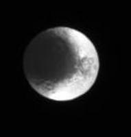
Hi,
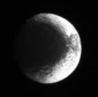
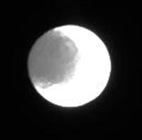
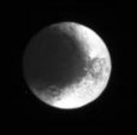
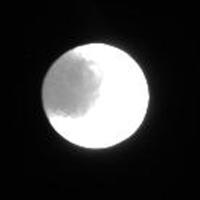
CASSINI has transmitted 184 pics (!) over the last days. Here five takeouts, 3-4x enlargement:
Date: 2009-09-06 Distance: 2.228.548 km Filters: CL1 and CL2
Date: 2009-09-08 Distance: 3.215.284 km Filters: P120 and GRN
Date: 2009-09-08 Distance: 3.216.610 km Filters: P60 and GRN
Date: 2009-09-09 Distance: 3.390.271km Filters: P60 and GRN
Date: 2009-09-09 Distance: 3.427.313 km Filters: P120 and GRN Maybe somebody is able to combine some of those images to show more details. Bye. |
|||||
 |
 
|
|||||
 |
|
Jul 11 2007, 06:32 PM
Post
#2
|
|
 Senior Member Group: Members Posts: 1648 Joined: 5-March 05 From: Boulder, CO Member No.: 184 |
Rob's image in post #125 is a good one to consider also. I redid my fit using the triaxial ellipsoid and allowing for a little scrunching just south of the bellyband on the western side. You can see my fit at this URL:
http://laps.noaa.gov/albers/sos/saturn/iap...o13_gridded.jpg The western limb of this image is still quite a distance away from the Ronceveaux Terra basin. My new fit agrees pretty closely with the older one though I have an offset in both a few degrees to the NW of the ISS map. So every correction that can be made will help though there's still quite some ways to go before I can make the RT basin inconsistency go away. I think that my map agrees with the ISS map (post #122) reasonably well for the Snowman craters and with the gridded ISS image for the Voyager mountains. Perhaps one of them may have to move significantly to really close the basin gap. The Voyager mountain agreement is illustrated at this URL: http://laps.noaa.gov/albers/sos/saturn/iap...o11_gridded.jpg In the middle pair of images the lower one is the ISS fit and the upper one is my (still spherical) fit. I just saw TA's new image so I'll think about that one as well. I see on the raw images page that there's no date or distance info so I wonder if the central longitude has shifted since the July 8 images? -------------------- Steve [ my home page and planetary maps page ]
|
|
|
|
|
Jul 11 2007, 09:06 PM
Post
#3
|
|
 Senior Member Group: Members Posts: 2530 Joined: 20-April 05 Member No.: 321 |
Could another component of the "basin gap" be that a broad basin rim shows up as shading on the eastern slopes of the (broad) rim in some lighting and as shading on the western slopes in opposite lighting?
http://www.phys.ncku.edu.tw/~astrolab/mirr...Orbiter4_c1.jpg With Mare Orientale on the Moon, for example, lighting from the east will show the eastern rim mainly as a shadow to the west of the highest level. Lighting from the west will show a shadow to the east of the highest level. This could amount to some 50-100 km perhaps if a basin's rims were really broad. |
|
|
|
 TritonAntares New Iapetian image series Sep 11 2006, 09:27 PM
 Michael Capobianco It looks like the big landslide basin has a subdue... Apr 23 2007, 06:51 PM angel1801 And I can tell you the images of Iapetus taken on ... Jul 4 2007, 02:17 PM Rob Pinnegar Yep, the big basin is nicely visible -- and what... Jul 4 2007, 02:57 PM Michael Capobianco So, could ejecta from the big southern basin have ... Jul 4 2007, 04:44 PM Phil Stooke Here's a composite of four frames, enlarged an... Jul 4 2007, 05:03 PM
 ugordan QUOTE (Phil Stooke @ Jul 4 2007, 06:03 PM... Jul 4 2007, 05:06 PM Rob Pinnegar This is a weird one.
The lack of bright craters ... Jul 5 2007, 03:43 PM angel1801 The images of Iapetus from July 8 are now in and r... Jul 9 2007, 09:16 AM Ian R Here's my version, consisting of 12 stacked im... Jul 9 2007, 10:30 AM ngunn Once again by the low-tech expedient of printing o... Jul 9 2007, 03:05 PM scalbers I think I might go out on a limb so to speak and i... Jul 9 2007, 08:45 PM Phil Stooke I'm fairly confident there is no double rim, a... Jul 9 2007, 09:19 PM scalbers I'll be interested to see whether things will ... Jul 9 2007, 11:26 PM Ian R Steve,
Could your problems be caused by the fact ... Jul 10 2007, 03:46 AM scalbers Ian,
That is a possibility to consider. This migh... Jul 10 2007, 08:18 PM Rob Pinnegar QUOTE (scalbers @ Jul 10 2007, 02:18 PM) ... Jul 11 2007, 12:18 AM Rob Pinnegar QUOTE (JRehling @ Jul 11 2007, 03:06 PM) ... Jul 12 2007, 03:25 PM volcanopele Regardless, it is always best to use the triaxial ... Jul 11 2007, 07:47 PM scalbers Interesting to look in more detail at structures o... Jul 15 2007, 01:30 PM Ian R Steve, you're more than welcome to use the sta... Jul 15 2007, 02:45 PM scalbers Thanks much Ian. Hopefully I'll have some time... Jul 15 2007, 03:01 PM Harkeppler These two view of Iapetus was made from 13 and 15 ... Jul 15 2007, 04:05 PM TritonAntares ...
Difficult to say which one exactly Hamon is, I... Jul 15 2007, 04:49 PM scalbers Nice illustration T/A. In some ways this looks pos... Jul 15 2007, 04:54 PM scalbers Greetings,
I'm in the midst of reviving my ma... Jul 17 2007, 06:57 PM Pavel QUOTE (scalbers @ Jul 17 2007, 02:57 PM) ... Jul 18 2007, 01:10 AM nprev New Iapetus article on the Cassini site:
http://s... Jul 18 2007, 12:39 AM scalbers It's from the rightmost image at this URL:
ht... Jul 18 2007, 04:45 PM edstrick When this orbit's long-range full-disk sequenc... Jul 19 2007, 05:08 AM scalbers Greetings,
I thought I'd show a blinking GIF ... Jul 19 2007, 05:29 PM MarcF It seems that there are indeed two overlaping big ... Jul 19 2007, 06:41 PM scalbers Yes, I must admit that the more I look at this the... Jul 22 2007, 02:58 PM TritonAntares QUOTE (scalbers @ Jul 22 2007, 04:58 PM) ... Jul 28 2007, 01:35 PM scalbers Greetings T-A,
Good questions worth considering g... Jul 28 2007, 04:10 PM edstrick I kept trying to convince myself that traces of ... Jul 29 2007, 07:48 AM Steve G Just a quick look tonight at Where is Cassini Now?... Jul 30 2007, 04:42 AM ugordan Here's another movie of an "ancient... Jul 30 2007, 05:44 PM Ian R Awesome! Gordan, you're a machine! Jul 31 2007, 06:49 AM Pavel QUOTE (Ian R @ Jul 31 2007, 02:49 AM) Awe... Jul 31 2007, 02:11 PM TritonAntares Hi,
let me just mention these three Iapetus far d... Jul 31 2007, 08:21 PM Rob Pinnegar QUOTE (TritonAntares @ Jul 31 2007, 02:21... Aug 2 2007, 12:57 AM TritonAntares QUOTE (Rob Pinnegar @ Aug 2 2007, 02:57 A... Aug 2 2007, 06:53 AM TritonAntares Btw., 9 additional far distance pics - including 3... Aug 4 2007, 10:25 AM scalbers Neat to see how things are setting up as we have 3... Aug 4 2007, 03:50 PM CAP-Team We're closing in on Iapetus!
Images from y... Sep 4 2007, 07:41 AM ugordan There's a rather neat "zero" phase o... Sep 20 2007, 09:16 PM scalbers Or would the grainier (snowy) material be in Ronce... Sep 23 2007, 01:19 PM ugordan It's quite possible, I was just trying to spar... Sep 23 2007, 01:54 PM scalbers Gordan - these are interesting animations that you... Sep 23 2007, 02:25 PM ugordan Interesting PDF from a glance, thanks for the link... Sep 24 2007, 01:54 PM ngunn Interesting. I would expect ice deposited as frost... Sep 24 2007, 04:20 PM CAP-Team Below images from 17, 19 and 23 september together... Sep 25 2007, 08:58 PM scalbers Nice views that you put together CAP-Team. One thi... Sep 29 2007, 01:47 PM
ugordan QUOTE (Phil Stooke @ Jul 4 2007, 06:03 PM... Jul 4 2007, 05:06 PM Rob Pinnegar This is a weird one.
The lack of bright craters ... Jul 5 2007, 03:43 PM angel1801 The images of Iapetus from July 8 are now in and r... Jul 9 2007, 09:16 AM Ian R Here's my version, consisting of 12 stacked im... Jul 9 2007, 10:30 AM ngunn Once again by the low-tech expedient of printing o... Jul 9 2007, 03:05 PM scalbers I think I might go out on a limb so to speak and i... Jul 9 2007, 08:45 PM Phil Stooke I'm fairly confident there is no double rim, a... Jul 9 2007, 09:19 PM scalbers I'll be interested to see whether things will ... Jul 9 2007, 11:26 PM Ian R Steve,
Could your problems be caused by the fact ... Jul 10 2007, 03:46 AM scalbers Ian,
That is a possibility to consider. This migh... Jul 10 2007, 08:18 PM Rob Pinnegar QUOTE (scalbers @ Jul 10 2007, 02:18 PM) ... Jul 11 2007, 12:18 AM Rob Pinnegar QUOTE (JRehling @ Jul 11 2007, 03:06 PM) ... Jul 12 2007, 03:25 PM volcanopele Regardless, it is always best to use the triaxial ... Jul 11 2007, 07:47 PM scalbers Interesting to look in more detail at structures o... Jul 15 2007, 01:30 PM Ian R Steve, you're more than welcome to use the sta... Jul 15 2007, 02:45 PM scalbers Thanks much Ian. Hopefully I'll have some time... Jul 15 2007, 03:01 PM Harkeppler These two view of Iapetus was made from 13 and 15 ... Jul 15 2007, 04:05 PM TritonAntares ...
Difficult to say which one exactly Hamon is, I... Jul 15 2007, 04:49 PM scalbers Nice illustration T/A. In some ways this looks pos... Jul 15 2007, 04:54 PM scalbers Greetings,
I'm in the midst of reviving my ma... Jul 17 2007, 06:57 PM Pavel QUOTE (scalbers @ Jul 17 2007, 02:57 PM) ... Jul 18 2007, 01:10 AM nprev New Iapetus article on the Cassini site:
http://s... Jul 18 2007, 12:39 AM scalbers It's from the rightmost image at this URL:
ht... Jul 18 2007, 04:45 PM edstrick When this orbit's long-range full-disk sequenc... Jul 19 2007, 05:08 AM scalbers Greetings,
I thought I'd show a blinking GIF ... Jul 19 2007, 05:29 PM MarcF It seems that there are indeed two overlaping big ... Jul 19 2007, 06:41 PM scalbers Yes, I must admit that the more I look at this the... Jul 22 2007, 02:58 PM TritonAntares QUOTE (scalbers @ Jul 22 2007, 04:58 PM) ... Jul 28 2007, 01:35 PM scalbers Greetings T-A,
Good questions worth considering g... Jul 28 2007, 04:10 PM edstrick I kept trying to convince myself that traces of ... Jul 29 2007, 07:48 AM Steve G Just a quick look tonight at Where is Cassini Now?... Jul 30 2007, 04:42 AM ugordan Here's another movie of an "ancient... Jul 30 2007, 05:44 PM Ian R Awesome! Gordan, you're a machine! Jul 31 2007, 06:49 AM Pavel QUOTE (Ian R @ Jul 31 2007, 02:49 AM) Awe... Jul 31 2007, 02:11 PM TritonAntares Hi,
let me just mention these three Iapetus far d... Jul 31 2007, 08:21 PM Rob Pinnegar QUOTE (TritonAntares @ Jul 31 2007, 02:21... Aug 2 2007, 12:57 AM TritonAntares QUOTE (Rob Pinnegar @ Aug 2 2007, 02:57 A... Aug 2 2007, 06:53 AM TritonAntares Btw., 9 additional far distance pics - including 3... Aug 4 2007, 10:25 AM scalbers Neat to see how things are setting up as we have 3... Aug 4 2007, 03:50 PM CAP-Team We're closing in on Iapetus!
Images from y... Sep 4 2007, 07:41 AM ugordan There's a rather neat "zero" phase o... Sep 20 2007, 09:16 PM scalbers Or would the grainier (snowy) material be in Ronce... Sep 23 2007, 01:19 PM ugordan It's quite possible, I was just trying to spar... Sep 23 2007, 01:54 PM scalbers Gordan - these are interesting animations that you... Sep 23 2007, 02:25 PM ugordan Interesting PDF from a glance, thanks for the link... Sep 24 2007, 01:54 PM ngunn Interesting. I would expect ice deposited as frost... Sep 24 2007, 04:20 PM CAP-Team Below images from 17, 19 and 23 september together... Sep 25 2007, 08:58 PM scalbers Nice views that you put together CAP-Team. One thi... Sep 29 2007, 01:47 PM |

|
Lo-Fi Version | Time is now: 18th June 2024 - 07:52 PM |
|
RULES AND GUIDELINES Please read the Forum Rules and Guidelines before posting. IMAGE COPYRIGHT |
OPINIONS AND MODERATION Opinions expressed on UnmannedSpaceflight.com are those of the individual posters and do not necessarily reflect the opinions of UnmannedSpaceflight.com or The Planetary Society. The all-volunteer UnmannedSpaceflight.com moderation team is wholly independent of The Planetary Society. The Planetary Society has no influence over decisions made by the UnmannedSpaceflight.com moderators. |
SUPPORT THE FORUM Unmannedspaceflight.com is funded by the Planetary Society. Please consider supporting our work and many other projects by donating to the Society or becoming a member. |
|