Voyager 2 Saturn Revisited, Still a lot to be processed and reprocessed |

Voyager 2 Saturn Revisited, Still a lot to be processed and reprocessed |
 Jan 20 2007, 02:36 AM Jan 20 2007, 02:36 AM
Post
#1
|
||||
 IMG to PNG GOD  Group: Moderator Posts: 2254 Joined: 19-February 04 From: Near fire and ice Member No.: 38 |
Emily recently mentioned in her blog the availability of calibrated and geometrically corrected Voyager images. Actually I had 'discovered' this dataset several months earlier but then managed to completely forget about it. Now I decided to do something so I downloaded volume 37 and decided to do some quick-and-dirty processing, mainly to check if it was feasible to do a very high resolution map (probably 25 degrees/pixel to match my Cassini map of the southern hemisphere) of Saturn's entire northern hemisphere by colorizing green filtered images using lower resolution color data I processed several years ago - at the resolution I want only green filtered images are available.
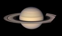
This was successful, opening the door to a new 'monster project': A very high resolution full color map of Saturn's entire northern hemisphere. First a color composite made from wide angle orange, green and blue images:
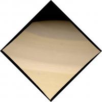
This one was made from images C4386547_GEOMED.IMG, C4386554_GEOMED.IMG and C4386608_GEOMED.IMG. I adjusted the color to something more realistic than I initially got and removed some reseau marks in Photoshop that were visible, especially near ring edges and Saturn's limb. Some color fringing was also visible on Saturn's disk due to Saturn's rotation while the three images were obtained; I removed this by cloning the color of adjacent areas. The spokes in the rings presented similar problems. I then colorized a green filtered image obtained at a similar time as the wide angle images above. This was the result:
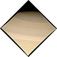
The image should be fairly realistic and I was happy with the result, especially because I didn't do this very carefully - something better should be possible. Finally the same image sharpened with an unsharp mask:
Lots of small scale details are visible, especially near the pole. I will probably post several additional Voyager Saturn images in the next several weeks. As previously mentioned, the plan now is to do a very high resolution map of Saturn's entire northern hemisphere based on these calibrated and rectified images. This means reprojecting the images to simple cylindrical projection. To do this I need to know the viewing geometry. Does anyone know if this information is available somewhere (or if not, if it's likely to ever become available)? I have some SPICE kernels which give me Voyager 2's location relative to Saturn. These are probably fairly accurate. However, the limited instrument pointing information I have is very inaccurate so it's useless to me. I can reverse engineer the viewing geometry/pointing but it's a lot of extra work. |
|||
 |
 
|
|||
 |
|
Jun 26 2007, 04:26 PM
Post
#2
|
|
 Administrator Group: Admin Posts: 5172 Joined: 4-August 05 From: Pasadena, CA, USA, Earth Member No.: 454 |
All right, it's all downloaded, and I've now posted all the rings and moons images. As for Saturn -- there's way too many to post. I'll have to consider what to do with those. I'll probably post a subset of them at some point, but I think I may wait until they've finished going through peer review. Apparently there's still some pretty serious problems with their dark current subtraction, which results in a goodly fraction of the images being badly calibrated, so they have to work on that.
http://planetary.org/explore/topics/voyager/rawdata.html --Emily -------------------- My website - My Patreon - @elakdawalla on Twitter - Please support unmannedspaceflight.com by donating here.
|
|
|
|
|
Jul 23 2007, 08:01 AM
Post
#3
|
|||||
|
Newbie Group: Members Posts: 19 Joined: 17-June 07 From: Near Southampton, UK Member No.: 2430 |
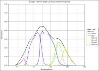
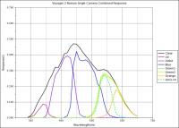
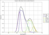
QUOTE (elakdawalla @ Jun 26 2007, 05:26 PM)  All right, it's all downloaded, and I've now posted all the rings and moons images. http://planetary.org/explore/topics/voyager/rawdata.html --Emily I noticed that on this page you have links to the Voyager camera calibration data. I discovered this a couple of years ago and made a spreadsheet to show how the different filters for each colour fit together. I used the *.TAB files at the Ring Node.
One thing you will notice is that the centre frequency and bandwidth of the filters are altered from their nominal values by the response of the optical path and the vidicon tube. Another thing to notice is that the response of the orange filter is completely contained within the green filter. So if you were composing a colour composite image using the green and orange pixel values, you would be counting the orange values twice, hence the green minus orange curve. Some double accounting also occurs between green and blue and between blue and violet, but the correction is less obvious. All this and more is in my spreadsheet. I made it using Gnumeric as Excel wouldn't quite do what I wanted. (Mmm, UMSF doesn't like Gnumeric spreadsheets for some reason, and the .xml version doesn't look right.) What you're missing is an approximation to how the human eye would see each filter colour, the RGB ratio for each filter and the area under each curve in the graphs above. These should help in constructing colour images from either the raw data with an appropriate calibration image subtracted, or from the calibrated or geometrically corrected images published by the Ring Node. Some scaling of pixel values is needed to correct for different exposure times, filter response (area under curve) and to avoid saturation. Cheers, Chris |
||||
|
|
|
||||
 Bjorn Jonsson Voyager 2 Saturn Revisited Jan 20 2007, 02:36 AM
 elakdawalla This is great; I can't wait to see what you... Jan 20 2007, 03:45 AM
 tedstryk This is some incredible work, Bjorn. Do you know ... Jan 20 2007, 05:07 AM PhilCo126 Great work to celebrate the 30th anniversary of th... Jan 20 2007, 02:19 PM elakdawalla QUOTE (Bjorn Jonsson @ Jan 19 2007, 06:36... Jan 20 2007, 05:36 PM Bjorn Jonsson No, I didn't know of these - they are new. Tha... Jan 20 2007, 08:45 PM elakdawalla Hi Bjorn,
I tried downloading the zipped versions... May 18 2007, 04:46 PM Bjorn Jonsson QUOTE (elakdawalla @ May 18 2007, 04:46 P... May 25 2007, 01:22 AM elakdawalla Great, thanks. It's nice to know I didn't... May 25 2007, 03:17 PM Bjorn Jonsson I have now fixed this bug. The new version is avai... May 26 2007, 01:46 PM elakdawalla Thanks! I tried the new version on one folder... May 26 2007, 02:00 PM elakdawalla Just posting an update here to mention that I... May 29 2007, 10:38 PM elakdawalla Seems I posted too soon. I was really rolling alo... Jun 4 2007, 03:28 PM Bjorn Jonsson Volumes 34-38 are there but you'll need to dow... Jun 4 2007, 04:11 PM elakdawalla I tried going to that Zip archives page but still ... Jun 4 2007, 04:17 PM Bjorn Jonsson QUOTE (elakdawalla @ Jun 4 2007, 04:17 PM... Jun 4 2007, 04:27 PM elakdawalla It could be that large file sizes are creating a p... Jun 4 2007, 04:32 PM Bjorn Jonsson I used GetRight for most/all of them. I don't ... Jun 4 2007, 04:39 PM elakdawalla Bjorn, your suspicion turns out to be right on tar... Jun 4 2007, 08:15 PM brellis QUOTE (elakdawalla @ Jun 4 2007, 01:15 PM... Jun 4 2007, 08:47 PM Bjorn Jonsson QUOTE (elakdawalla @ Jun 4 2007, 08:15 PM... Jun 5 2007, 12:45 AM elakdawalla I just heard again from Mark Showalter, who says t... Jun 21 2007, 08:58 PM Bjorn Jonsson QUOTE (elakdawalla @ Jun 26 2007, 04:26 P... Jun 27 2007, 12:45 AM tedstryk QUOTE (Bjorn Jonsson @ Jun 27 2007, 12:45... Jun 27 2007, 01:13 AM ChrisP QUOTE (elakdawalla @ Jun 26 2007, 05:26 P... Jul 23 2007, 06:36 AM elakdawalla QUOTE (ChrisP @ Jul 22 2007, 11:36 PM) No... Jul 23 2007, 04:09 PM AlexBlackwell I just wanted to say that your space imaging effor... Jun 26 2007, 06:26 PM ChrisP One minor nit on your new raw images page Emily, t... Jun 26 2007, 10:51 PM elakdawalla Woops. I fixed the Mimas and Tethys links.
The p... Jun 26 2007, 11:27 PM ChrisP Thanks for fixing the links.
The GIMP doesn't... Jun 26 2007, 11:54 PM elakdawalla Hi Chris, I'd be happy to add instructions reg... Jun 27 2007, 02:02 AM ChrisP QUOTE (elakdawalla @ Jun 27 2007, 03:02 A... Jun 28 2007, 12:34 AM ugordan Wow, the Voyager data is certainly ress rewarding ... Jun 27 2007, 12:39 PM tedstryk QUOTE (ugordan @ Jun 27 2007, 12:39 PM) W... Jun 28 2007, 03:36 AM tedstryk QUOTE (ugordan @ Jun 27 2007, 12:39 PM) W... Nov 1 2007, 02:52 AM ugordan That's a really nice Enceladus image. Very Cas... Nov 2 2007, 02:00 PM edstrick I did some systematic experimental work on partial... Jul 23 2007, 07:05 AM ChrisP QUOTE (edstrick @ Jul 23 2007, 08:05 AM) ... Jul 23 2007, 08:16 AM ChrisP Thanks for that link to the reviews webpage Emily,... Jul 24 2007, 01:00 AM PhilCo126 Time flies... Nov 2 2007, 06:28 PM PhilCo126 At least for Voyager 2 there was the 1986 prospect Nov 3 2007, 06:25 PM machi Old Hyperion flyby movie.
It's maked from six ... Dec 4 2009, 03:06 PM ElkGroveDan Wow. Good work. Dec 4 2009, 03:20 PM Ian R Machi, you are rapidly becoming one of my favourit... Dec 4 2009, 04:18 PM tedstryk Amazing animation! Dec 8 2009, 02:03 AM lyford At the risk of sounding like a cliche, that was pr... Dec 8 2009, 02:21 AM nprev I'll second that cliche... VERY cool, Machi... Dec 8 2009, 03:04 AM Hungry4info That is pretty cool. You can just make out the dee... Dec 8 2009, 07:59 AM tedstryk I worked on this sequence back in 2005 but never t... Dec 8 2009, 07:30 PM elakdawalla Since no one else has mentioned it yet, I just wan... Dec 8 2009, 07:57 PM tedstryk Holy Cow! I never clicked to enlarge, so I th... Dec 8 2009, 08:08 PM ugordan Yep, Bjorn posted the image here a while ago and i... Dec 8 2009, 08:12 PM Bjorn Jonsson QUOTE (elakdawalla @ Dec 8 2009, 07:57 PM... Dec 9 2009, 11:59 AM tedstryk My closer Galileo mosaic is also very high resolut... Dec 9 2009, 04:22 PM jasedm I second this - I've nabbed it for my desktop ... Dec 8 2009, 08:11 PM elakdawalla Actually, this one is better than the one you saw ... Dec 8 2009, 08:23 PM machi Thanks for comments!
And Jupiter from Björ... Dec 8 2009, 08:38 PM JohnVV i could have used that vid of Hyperion when i did ... Dec 8 2009, 11:05 PM Phil Stooke Very interesting!
Phil Dec 8 2009, 11:37 PM Ian R The color isn't perfect, and indeed one or two... Jun 23 2015, 06:25 PM Bjorn Jonsson Wow.
This is probably the best Voyager Saturn movi... Jun 23 2015, 06:44 PM ZLD Absolutely stunning work Ian! Jun 23 2015, 07:05 PM ElkGroveDan Very impressive Ian. Jun 24 2015, 02:10 AM Ian R Thanks guys! I did this last year, and given... Jun 24 2015, 03:53 AM jgoldader Ian: just... wow! Riding along with Voyager i... Jun 24 2015, 06:52 PM PDP8E Ian, nice work! thanks Jun 24 2015, 09:05 PM Ian R This is how the very same sequence was presented b... Jun 24 2015, 10:13 PM ZLD This makes it much clearer how impressive your ver... Jun 24 2015, 10:39 PM DrShank QUOTE (ZLD @ Jun 24 2015, 04:39 PM) This ... Jun 28 2015, 12:57 PM Floyd Ian, your work impressively demonstrates how much ... Jun 28 2015, 02:18 PM jasedm Stunning work Ian, thanks for sharing with us... Jun 28 2015, 06:50 PM Rob Pinnegar Beautiful job Ian -- really nice work. Jul 4 2015, 05:11 AM Ian R With my grateful thanks to Tanya and Emily of The ... Jul 12 2015, 07:18 PM Astroboy Here's something kind of simple... the Saturn ... Aug 8 2016, 04:11 PM Brian Burns This is really cool - it's great to see all th... Aug 8 2016, 04:54 PM Astroboy Thanks! I'm looking at a few more possible... Aug 8 2016, 05:39 PM jccwrt Here's a picture of Prometheus against the bac... Feb 14 2019, 03:01 AM Ian R
https://vimeo.com/665079286
Over the course of ... Jan 12 2022, 05:54 AM vikingmars QUOTE (Ian R @ Jan 12 2022, 06:54 AM) htt... Jan 12 2022, 04:56 PM Bjorn Jonsson WOW!! This may very well be the best Voyag... Jan 12 2022, 05:50 PM
tedstryk This is some incredible work, Bjorn. Do you know ... Jan 20 2007, 05:07 AM PhilCo126 Great work to celebrate the 30th anniversary of th... Jan 20 2007, 02:19 PM elakdawalla QUOTE (Bjorn Jonsson @ Jan 19 2007, 06:36... Jan 20 2007, 05:36 PM Bjorn Jonsson No, I didn't know of these - they are new. Tha... Jan 20 2007, 08:45 PM elakdawalla Hi Bjorn,
I tried downloading the zipped versions... May 18 2007, 04:46 PM Bjorn Jonsson QUOTE (elakdawalla @ May 18 2007, 04:46 P... May 25 2007, 01:22 AM elakdawalla Great, thanks. It's nice to know I didn't... May 25 2007, 03:17 PM Bjorn Jonsson I have now fixed this bug. The new version is avai... May 26 2007, 01:46 PM elakdawalla Thanks! I tried the new version on one folder... May 26 2007, 02:00 PM elakdawalla Just posting an update here to mention that I... May 29 2007, 10:38 PM elakdawalla Seems I posted too soon. I was really rolling alo... Jun 4 2007, 03:28 PM Bjorn Jonsson Volumes 34-38 are there but you'll need to dow... Jun 4 2007, 04:11 PM elakdawalla I tried going to that Zip archives page but still ... Jun 4 2007, 04:17 PM Bjorn Jonsson QUOTE (elakdawalla @ Jun 4 2007, 04:17 PM... Jun 4 2007, 04:27 PM elakdawalla It could be that large file sizes are creating a p... Jun 4 2007, 04:32 PM Bjorn Jonsson I used GetRight for most/all of them. I don't ... Jun 4 2007, 04:39 PM elakdawalla Bjorn, your suspicion turns out to be right on tar... Jun 4 2007, 08:15 PM brellis QUOTE (elakdawalla @ Jun 4 2007, 01:15 PM... Jun 4 2007, 08:47 PM Bjorn Jonsson QUOTE (elakdawalla @ Jun 4 2007, 08:15 PM... Jun 5 2007, 12:45 AM elakdawalla I just heard again from Mark Showalter, who says t... Jun 21 2007, 08:58 PM Bjorn Jonsson QUOTE (elakdawalla @ Jun 26 2007, 04:26 P... Jun 27 2007, 12:45 AM tedstryk QUOTE (Bjorn Jonsson @ Jun 27 2007, 12:45... Jun 27 2007, 01:13 AM ChrisP QUOTE (elakdawalla @ Jun 26 2007, 05:26 P... Jul 23 2007, 06:36 AM elakdawalla QUOTE (ChrisP @ Jul 22 2007, 11:36 PM) No... Jul 23 2007, 04:09 PM AlexBlackwell I just wanted to say that your space imaging effor... Jun 26 2007, 06:26 PM ChrisP One minor nit on your new raw images page Emily, t... Jun 26 2007, 10:51 PM elakdawalla Woops. I fixed the Mimas and Tethys links.
The p... Jun 26 2007, 11:27 PM ChrisP Thanks for fixing the links.
The GIMP doesn't... Jun 26 2007, 11:54 PM elakdawalla Hi Chris, I'd be happy to add instructions reg... Jun 27 2007, 02:02 AM ChrisP QUOTE (elakdawalla @ Jun 27 2007, 03:02 A... Jun 28 2007, 12:34 AM ugordan Wow, the Voyager data is certainly ress rewarding ... Jun 27 2007, 12:39 PM tedstryk QUOTE (ugordan @ Jun 27 2007, 12:39 PM) W... Jun 28 2007, 03:36 AM tedstryk QUOTE (ugordan @ Jun 27 2007, 12:39 PM) W... Nov 1 2007, 02:52 AM ugordan That's a really nice Enceladus image. Very Cas... Nov 2 2007, 02:00 PM edstrick I did some systematic experimental work on partial... Jul 23 2007, 07:05 AM ChrisP QUOTE (edstrick @ Jul 23 2007, 08:05 AM) ... Jul 23 2007, 08:16 AM ChrisP Thanks for that link to the reviews webpage Emily,... Jul 24 2007, 01:00 AM PhilCo126 Time flies... Nov 2 2007, 06:28 PM PhilCo126 At least for Voyager 2 there was the 1986 prospect Nov 3 2007, 06:25 PM machi Old Hyperion flyby movie.
It's maked from six ... Dec 4 2009, 03:06 PM ElkGroveDan Wow. Good work. Dec 4 2009, 03:20 PM Ian R Machi, you are rapidly becoming one of my favourit... Dec 4 2009, 04:18 PM tedstryk Amazing animation! Dec 8 2009, 02:03 AM lyford At the risk of sounding like a cliche, that was pr... Dec 8 2009, 02:21 AM nprev I'll second that cliche... VERY cool, Machi... Dec 8 2009, 03:04 AM Hungry4info That is pretty cool. You can just make out the dee... Dec 8 2009, 07:59 AM tedstryk I worked on this sequence back in 2005 but never t... Dec 8 2009, 07:30 PM elakdawalla Since no one else has mentioned it yet, I just wan... Dec 8 2009, 07:57 PM tedstryk Holy Cow! I never clicked to enlarge, so I th... Dec 8 2009, 08:08 PM ugordan Yep, Bjorn posted the image here a while ago and i... Dec 8 2009, 08:12 PM Bjorn Jonsson QUOTE (elakdawalla @ Dec 8 2009, 07:57 PM... Dec 9 2009, 11:59 AM tedstryk My closer Galileo mosaic is also very high resolut... Dec 9 2009, 04:22 PM jasedm I second this - I've nabbed it for my desktop ... Dec 8 2009, 08:11 PM elakdawalla Actually, this one is better than the one you saw ... Dec 8 2009, 08:23 PM machi Thanks for comments!
And Jupiter from Björ... Dec 8 2009, 08:38 PM JohnVV i could have used that vid of Hyperion when i did ... Dec 8 2009, 11:05 PM Phil Stooke Very interesting!
Phil Dec 8 2009, 11:37 PM Ian R The color isn't perfect, and indeed one or two... Jun 23 2015, 06:25 PM Bjorn Jonsson Wow.
This is probably the best Voyager Saturn movi... Jun 23 2015, 06:44 PM ZLD Absolutely stunning work Ian! Jun 23 2015, 07:05 PM ElkGroveDan Very impressive Ian. Jun 24 2015, 02:10 AM Ian R Thanks guys! I did this last year, and given... Jun 24 2015, 03:53 AM jgoldader Ian: just... wow! Riding along with Voyager i... Jun 24 2015, 06:52 PM PDP8E Ian, nice work! thanks Jun 24 2015, 09:05 PM Ian R This is how the very same sequence was presented b... Jun 24 2015, 10:13 PM ZLD This makes it much clearer how impressive your ver... Jun 24 2015, 10:39 PM DrShank QUOTE (ZLD @ Jun 24 2015, 04:39 PM) This ... Jun 28 2015, 12:57 PM Floyd Ian, your work impressively demonstrates how much ... Jun 28 2015, 02:18 PM jasedm Stunning work Ian, thanks for sharing with us... Jun 28 2015, 06:50 PM Rob Pinnegar Beautiful job Ian -- really nice work. Jul 4 2015, 05:11 AM Ian R With my grateful thanks to Tanya and Emily of The ... Jul 12 2015, 07:18 PM Astroboy Here's something kind of simple... the Saturn ... Aug 8 2016, 04:11 PM Brian Burns This is really cool - it's great to see all th... Aug 8 2016, 04:54 PM Astroboy Thanks! I'm looking at a few more possible... Aug 8 2016, 05:39 PM jccwrt Here's a picture of Prometheus against the bac... Feb 14 2019, 03:01 AM Ian R
https://vimeo.com/665079286
Over the course of ... Jan 12 2022, 05:54 AM vikingmars QUOTE (Ian R @ Jan 12 2022, 06:54 AM) htt... Jan 12 2022, 04:56 PM Bjorn Jonsson WOW!! This may very well be the best Voyag... Jan 12 2022, 05:50 PM |

|
Lo-Fi Version | Time is now: 26th September 2024 - 08:27 PM |
|
RULES AND GUIDELINES Please read the Forum Rules and Guidelines before posting. IMAGE COPYRIGHT |
OPINIONS AND MODERATION Opinions expressed on UnmannedSpaceflight.com are those of the individual posters and do not necessarily reflect the opinions of UnmannedSpaceflight.com or The Planetary Society. The all-volunteer UnmannedSpaceflight.com moderation team is wholly independent of The Planetary Society. The Planetary Society has no influence over decisions made by the UnmannedSpaceflight.com moderators. |
SUPPORT THE FORUM Unmannedspaceflight.com is funded by the Planetary Society. Please consider supporting our work and many other projects by donating to the Society or becoming a member. |
|