South Pole in 3D |

South Pole in 3D |
 Apr 7 2011, 03:13 PM Apr 7 2011, 03:13 PM
Post
#1
|
|||
|
Newbie  Group: Members Posts: 2 Joined: 16-November 10 From: France Member No.: 5526 |
Hello,
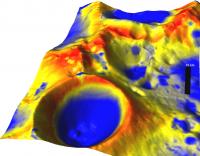
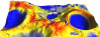
this is the first time I post on this forum. I would like to take the opportunity to thank you all for the inspiration you provided with your beautiful images and excellent work. After perusing the forums for a while I decided to start producing some planetary maps for some research project I was involved with and because it is really cool! I used the LOLA grided release and ISIS3 to read the LOLA files and produce .cub files. I used GRASS GIS to read these files (reads directly cub files). I then made an overlay from the illumination map that LROC team made for the Lunar South Pole. LROC SP Illumination Map . Finally, I used the nviz function of GRASS to tranform the LOLA data in 3D and overlay the illumination map as a "red to blue" colormap. So in these pictures, red means more illumination and blue means less illumination. The scale can be seen on the first map. I attach two of the images. hope you like it best regards Emmanouil
Attached thumbnail(s)
|
||
 |
 
|
||
 emd South Pole in 3D Apr 7 2011, 03:13 PM
 Phil Stooke These are very nice, and I congratulate you for do... Apr 7 2011, 04:07 PM
 pgrindrod I second that - nice work Emmanouil! You'v... Apr 7 2011, 05:26 PM emd Heh, thanks for the correction guys. It is indeed ... Apr 8 2011, 04:02 PM
  |

|
Lo-Fi Version | Time is now: 24th September 2024 - 05:57 AM |
|
RULES AND GUIDELINES Please read the Forum Rules and Guidelines before posting. IMAGE COPYRIGHT |
OPINIONS AND MODERATION Opinions expressed on UnmannedSpaceflight.com are those of the individual posters and do not necessarily reflect the opinions of UnmannedSpaceflight.com or The Planetary Society. The all-volunteer UnmannedSpaceflight.com moderation team is wholly independent of The Planetary Society. The Planetary Society has no influence over decisions made by the UnmannedSpaceflight.com moderators. |
SUPPORT THE FORUM Unmannedspaceflight.com is funded by the Planetary Society. Please consider supporting our work and many other projects by donating to the Society or becoming a member. |
|