

Reprocessing Historical Images, Looking for REALLY big challenges? |

  |
Reprocessing Historical Images, Looking for REALLY big challenges? |
 May 18 2005, 08:43 PM May 18 2005, 08:43 PM
Post
#46
|
|
 Senior Member  Group: Members Posts: 2488 Joined: 17-April 05 From: Glasgow, Scotland, UK Member No.: 239 |
Fascinating!
-------------------- Remember: Time Flies like the wind - but Fruit Flies like bananas!
|
 |
 
|
|
May 22 2005, 07:49 PM
Post
#47
|
|
 Interplanetary Dumpster Diver Group: Admin Posts: 4404 Joined: 17-February 04 From: Powell, TN Member No.: 33 |
QUOTE (Bob Shaw @ May 18 2005, 08:43 PM) Fascinating!  Does anyone know a good program for manually entering numerical values from a paper copy to make an image file? I could do it in Photoshop, but it would take forever and a day. -------------------- |
|
|
|
|
May 22 2005, 11:23 PM
Post
#48
|
|
 IMG to PNG GOD Group: Moderator Posts: 2251 Joined: 19-February 04 From: Near fire and ice Member No.: 38 |
QUOTE (tedstryk @ May 22 2005, 07:49 PM) Does anyone know a good program for manually entering numerical values from a paper copy to make an image file? I could do it in Photoshop, but it would take forever and a day. If you have these numbers in a simple text file I can easily convert the file to a PNG (and if this because of the Pioneer images mentioned earlier in the thread then this is something I myself am interested in). |
|
|
|
|
May 23 2005, 12:06 AM
Post
#49
|
|
|
Interplanetary Dumpster Diver Group: Admin Posts: 4404 Joined: 17-February 04 From: Powell, TN Member No.: 33 |
[quote=Bjorn Jonsson,May 22 2005, 11:23 PM]
[quote=tedstryk,May 22 2005, 07:49 PM]Does anyone know a good program for manually entering numerical values from a paper copy to make an image file? I could do it in Photoshop, but it would take forever and a day.[/quote] If you have these numbers in a simple text file I can easily convert the file to a PNG (and if this because of the Pioneer images mentioned earlier in the thread then this is something I myself am interested in). [/quote I can work on entering them...unfortunately, the old 1970s typewriter that wrote the document was of such poor quality that I will have to enter the numbers manually, but I will e-mail you the files when I get done. -------------------- |
|
|
|
|
May 23 2005, 02:16 AM
Post
#50
|
|
|
Member Group: Members Posts: 123 Joined: 21-February 05 Member No.: 175 |
.
|
|
|
|
|
May 23 2005, 03:09 AM
Post
#51
|
|
|
Solar System Cartographer Group: Members Posts: 10186 Joined: 5-April 05 From: Canada Member No.: 227 |
I didn't do the geometric correction!
The original mosaics were assembled by hand and re-photographed. Two sets were made - at USGS and JPL. At USGS the mosaics were assembled on the insides of hemispherical bowls about 1 m diameter, one of which is still preserved in a display at Flagstaff (Surveyor 7, a sunset view that I have never seen published, with shadows falling across the 'playa' area north of the lander). At JPL they did the same, but separately and possibly (I'm not sure) on larger bowls. The USGS ones were photographed in small sections at high resolution. The JPL ones were photographed using an ingenious geometry that produced rectangular prints - ten of which can be fitted together to make a cylindrical 360 degree panorama. So the geometric correction was done that way, a true physical projection. I recently scanned the pan sections and I am now painstakingly removing the hideous seams and tonal variations. The results look good for Surveyors 1 and 7 but a bit bland for Surveyors 3 and 5 - I have not done 6 yet, but it will be bland too. Phil -------------------- ... because the Solar System ain't gonna map itself.
Also to be found posting similar content on https://mastodon.social/@PhilStooke Maps for download (free PD: https://upload.wikimedia.org/wikipedia/comm...Cartography.pdf NOTE: everything created by me which I post on UMSF is considered to be in the public domain (NOT CC, public domain) |
|
|
|
|
May 23 2005, 04:58 AM
Post
#52
|
|
|
Senior Member Group: Members Posts: 1870 Joined: 20-February 05 Member No.: 174 |
A number of postings back, somebody was "dissing" the Pioneer Spin-Scan Multi-Polariimiter/Camera as a primitive camera. I'd like to come, a bit, to it's defense.
The camera was actually 3 instruments in one. It was a zodiacal light photometer/polarimiter. On it's way out to Jupiter and beyond, it repeatedly imaged the entire sky except near the sun in red and blue light with full polarization analysis abilities. The resolution was terrible, about 1 or 1 1/2 degrees, but they were mapping the skyglow of the solarsystem, not taking pictures. They proved that the backscattered glow from the zodiacal light disappeared as you went through the asteroid belt to undetectably low levels, and proved that the gegenshein <counterglow--a bright patch in the zodiacal light centered on zero degree phase angle> was a photometric effect, and not due to a dust-cloud orbiting the sun at say the earth's L2 point. Processing the zodiacal photometry stuff involved mapping the pixels onto the celestial sphere, identifying detectible stars in each field of view, and subtracting the calculated starlight to get sky maps free from bright star contamination. The team doing this work never produces sky-map images from the data, and I've always wanted to see color/polarization maps of the sky from the Pioneers. The cameras also took intermediate resolution spin-scan polarimetry maps of Jupiter and Saturn with the disks well resolved at a full range of phase angles, not available from earth. Again, the images were 2 color, with full polarization analysys. This provided large amounts of QUANTITATIVE information on light scattering by cloud particles in the upper troposphere and stratosphere, data that was not duplicated or improved on in any way by the Voyagers. This data was and continues to be of use in modeling the structure of the visible parts of these planet's atmospheres. Finally, the best images from Pioneer 10 had resolution approaching Voyager's best. Pioneer took a picture with 60 km/pixel <if I recall> resolution at closest approach. It''s reproduced in the Journal of Geophysical Research's Pioneer 10 special issue. Radiation hits caused the gain of the camera <basically exposure> to shift a few times during the sequence, and the data has a strong periodic noise component possibly associated with radiation hitting the spinning spacecraft, but it couild and should have been restored and composited into a color image. Voyager's best resolutions on Jupiter were only some 15 to 20 km. |
|
|
|
|
May 23 2005, 06:44 AM
Post
#53
|
|
 Senior Member Group: Members Posts: 3419 Joined: 9-February 04 From: Minneapolis, MN, USA Member No.: 15 |
QUOTE (edstrick @ May 22 2005, 11:58 PM) A number of postings back, somebody was "dissing" the Pioneer Spin-Scan Multi-Polariimiter/Camera as a primitive camera. I'd like to come, a bit, to it's defense.... Oh, I wasn't saying they didn't do some amazing things with that instrument. My point was (and remains) that it was not primarily an imaging system, and because of that, it was unable to take anything like the total number of pictures a dedicated imaging system would have, and, indeed, the highest resolution Pioneer images I've ever seen, though they may have similar theoretical resolution to Voyager images, all appeared to retain aberrations and "blurring" factors that made them appear far less clear than the average Voyager image. I suppose it's possible that I have never seen properly corrected and cleaned-up Pioneer images -- do you have any links for high-quality versions? (Beg, beg...) -the other Doug -------------------- The trouble ain't that there is too many fools, but that the lightning ain't distributed right. -Mark Twain
|
|
|
|
|
May 23 2005, 09:49 AM
Post
#54
|
|
|
Senior Member Group: Members Posts: 1870 Joined: 20-February 05 Member No.: 174 |
I don't know any links, the Pioneer team never did a very good job of publicising their pictures other than the 3 versions of the NASA SP Pioneer book. They never did any real post processing either, after making final versions of most of the pics. I always though there was a lot more they could have done, starting with putting the raw and final versions of the pics on digital tape at the NSSDC.
I always found most interesting that "boiling porridge" of features in the Pioneer 11 pics of Jupiter's polar regions, something we have never seen since nearly as well. |
|
|
|
|
May 23 2005, 10:23 AM
Post
#55
|
|
|
Senior Member Group: Members Posts: 2488 Joined: 17-April 05 From: Glasgow, Scotland, UK Member No.: 239 |
The Surveyor hemispherical panorama domes (there *must* be a proper name for the things!) were featured in, as I recall, a 1966 or 1967 issue of National Geographic - one of the 'How The US Will Conquer Our Nearest Neghbor' sort of articles which they did quite regularly.
-------------------- Remember: Time Flies like the wind - but Fruit Flies like bananas!
|
|
|
|
|
May 23 2005, 03:48 PM
Post
#56
|
|
 Senior Member Group: Members Posts: 1281 Joined: 18-December 04 From: San Diego, CA Member No.: 124 |
QUOTE (edstrick @ May 23 2005, 01:49 AM) I don't know any links, the Pioneer team never did a very good job of publicising their pictures other than the 3 versions of the NASA SP Pioneer book. That book is availabe online here. Chapter 7 has a good description of the imaging process, including comparing raw and corrected pics. Here's a side by side of the best I could find of Pioneer with a "typical" Voyager shot: (Apologies to those without broadband or who have seen these before. Please let me know if these images are too large or load too slowly and I will edit them to be links only.) Pioneer 11 :  Voyager 1 and 2:  Pioneer 11 capture the first detail from the polar view:  Pioneer 11 even caught IO! 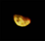
-------------------- Lyford Rome
"Zis is not nuts, zis is super-nuts!" Mathematician Richard Courant on viewing an Orion test |
|
|
|
|
May 23 2005, 08:26 PM
Post
#57
|
|
|
IMG to PNG GOD Group: Moderator Posts: 2251 Joined: 19-February 04 From: Near fire and ice Member No.: 38 |
I made a preliminary page containing several Pioneer 10 and 11 images scanned from Pioneer: First to Jupiter, Saturn and Beyond (NASA SP-446). Back at the time I acquired this book (years ago) I was surprised the images weren't worse, before I had only seen very crude reproductions of the images.
The page is at http://www.mmedia.is/bjj/misc/pioneer/index.html . I will add more images later. These images are interesting, the belt where the Great Red Spot (GRS) resides was bright at the time of the Pioneer flybys and the GRS's color was far more saturated than it has been ever since. This contrasts with Jupiter's appearance in Voyager, Galileo and Cassini images. Also the Pioneer 11 images of Jupiter's north polar region are still the best images available of the polar regions. It would be very interesting to reprocess the original data using modern computers and software. |
|
|
|
|
May 23 2005, 09:41 PM
Post
#58
|
|
|
Member Group: Members Posts: 378 Joined: 21-April 05 From: Portugal Member No.: 347 |
QUOTE (lyford @ May 23 2005, 04:48 PM) That book is availabe online here. Chapter 7 has a good description of the imaging process, including comparing raw and corrected pics. It's possible to create some "new" imagens from the Red/Blue raw images avaliable on that book. I've tried and the results improve a little, but we are still working with scanned images... So we really need to process the digital data. Perhaps the members of this forum might help in typing those numbers... Just post the scanned JPG here and we can reply with the typed data. -------------------- _______________________
www.astrosurf.com/nunes |
|
|
|
|
May 23 2005, 10:07 PM
Post
#59
|
|
|
Solar System Cartographer Group: Members Posts: 10186 Joined: 5-April 05 From: Canada Member No.: 227 |
A few more words about the Surveyor panoramas. The first step was to find prints of the original pans for scanning. I often work at LPI in Houston, so on one trip I looked through the Surveyor stuff. They have all or most of the original frames archived as photo negatives, box after box of them - 80,000 total. But indexing is complex and messy, and besides I didn't have time to work that way. But they had dozens of folders of prints. I searched every folder. A few were mis-labelled, which didn't help. (I added a correct annotation but they are still filed with the incorrect labelling).
Among thousands of prints of individual frames or small mosaics were lots of 'regional-scale' mosaics, but most were compiled only for indexing/coverage plotting purposes and are 'aesthetically challenged' beyond belief. Ray Batson said they were compiled as the pics were coming off the printers to check for gaps in coverage etc., and they could barely keep up. The useful ones are called "improved mosaics", made for science rather than mission operations. The tonal variations were reduced by processing (in the dark room, mainly) to give better-looking results. The collection includes a lot of mosaic fragments (sectors) with different lighting, but most in local projections which would take a lot of work to fit together. I needed the rectangular versions made at JPL which fit together into cylindrical pans. At LPI I found enough sections to do Surveyor 1, Surveyor 3, and Surveyor 7. These were 8 by 10 inch prints, one print per section, but sharp, and scanned well to give fairly detailed images. Full pans are about 10000 to 15000 pixels wide, each made of ten of these sections. LPI didn't have these for Surveyors 5 and 6. JPL didn't seem to have retained them - maybe in their archives which are a bit tricky to use like this. Later I went to LPL in Tucson. They had large format prints of Surveyor pans, including Surveyors 3 and 5 which I scanned. They have the best Surveyor 3 material, including excellent prints of the horizon. Finally I spent a week at Flagstaff. USGS in Flagstaff had Surveyor 6 and a set of prints of a Surveyor 7 pan - but not in cylindrical format - which is different from the one I have done, taken near sunset. I'll post some details later. So between these locations I found the full data set that I needed. There is a LOT more to be done with the Surveyors, if anyone feels like a challenge! Phil -------------------- ... because the Solar System ain't gonna map itself.
Also to be found posting similar content on https://mastodon.social/@PhilStooke Maps for download (free PD: https://upload.wikimedia.org/wikipedia/comm...Cartography.pdf NOTE: everything created by me which I post on UMSF is considered to be in the public domain (NOT CC, public domain) |
|
|
|
|
May 24 2005, 06:58 AM
Post
#60
|
|
|
Senior Member Group: Members Posts: 3419 Joined: 9-February 04 From: Minneapolis, MN, USA Member No.: 15 |
QUOTE (Phil Stooke @ May 23 2005, 05:07 PM) A few more words about the Surveyor panoramas. The first step was to find prints of the original pans for scanning. I often work at LPI in Houston, so on one trip I looked through the Surveyor stuff. They have all or most of the original frames archived as photo negatives, box after box of them - 80,000 total... As I understand it, the original television signals were not captured and recorded, the only permanent record of the images are these negatives and any prints made from them, correct? Let's see -- the Surveyor camera had a low-res 200-line mode and a high-res 600-line mode, if memory serves. It seems to me that what *really* needs to be done is for the negatives (yes, all 80,000+ of them) to be scanned directly, using a scanner that scans each individual line of the television image and generates a "line" of pixels that most closely represents that line of the original television signal. You could then assemble those lines into digital images that can be both stored far longer and more securely than the negatives and can be manipulated to create highest-possible-quality images and panoramas. (Since you're scanning negatives, you'd just reverse the grayscale somewhere in the process to create positive images.) In addition, since the mirror position on the camera was probably slightly variable, you might even be able to generate super-resolution images by overlaying images taken of the same scene in the same lighting conditions. At least three of the Surveyors survived long enough to image the same patches of real estate several times at very similar lighting angles over two or three lunar days. It would not be a cheap process -- it would have to be a government-funded project, I imagine. Maybe it could be sold on the basis of preservation of historical data. But I can well imagine being able to design a scanning system that would accurately scan each TV line and create a high-quality digital version of the image. It would require precise negative positioning control and the width and "targeting" of the scanning beam would have to be custom-designed and precisely controlled, but given ten or fifteen million dollars, a staff of 10 or 15 people, and a couple of years, I bet it could be done quite effectively. -the other Doug -------------------- The trouble ain't that there is too many fools, but that the lightning ain't distributed right. -Mark Twain
|
|
|
|
|

|
Lo-Fi Version | Time is now: 6th June 2024 - 05:30 PM |
|
RULES AND GUIDELINES Please read the Forum Rules and Guidelines before posting. IMAGE COPYRIGHT |
OPINIONS AND MODERATION Opinions expressed on UnmannedSpaceflight.com are those of the individual posters and do not necessarily reflect the opinions of UnmannedSpaceflight.com or The Planetary Society. The all-volunteer UnmannedSpaceflight.com moderation team is wholly independent of The Planetary Society. The Planetary Society has no influence over decisions made by the UnmannedSpaceflight.com moderators. |
SUPPORT THE FORUM Unmannedspaceflight.com is funded by the Planetary Society. Please consider supporting our work and many other projects by donating to the Society or becoming a member. |
|


