Phoenix Sun, Sun elevation at Phoenix lander site |

  |
Phoenix Sun, Sun elevation at Phoenix lander site |
 Jun 6 2008, 05:20 PM Jun 6 2008, 05:20 PM
Post
#16
|
|
 Dublin Correspondent  Group: Admin Posts: 1799 Joined: 28-March 05 From: Celbridge, Ireland Member No.: 220 |
It would help if I actually read my own link properly.
 Thanks Mike, that's exactly correct. |
 |
 
|
|
Jun 6 2008, 05:42 PM
Post
#17
|
|
 Senior Member Group: Members Posts: 2530 Joined: 20-April 05 Member No.: 321 |
I love graphs like this. Though I thought this thread might be about the basketball team, from the name.
The spirit of the MERs is still with us. We want to see more of this scenery, the changing seasons, and have it go on and on. But this site was chosen as a place which is almost dimensionless in time and space. That's a sea of ice underfoot and aside from the polygons and some pebbles, this area is isotropic all the way to the horizon. Phoenix's whole mission will essentially be one long weatherless day with nothing happening to its right, its left, its front or its back. The story is in the nuclei of the atoms underfoot. How long has the ice on the surface of the sub-dust layer been there -- since the last change of seasons, the last change in obliquity, or since the planet was put together from its building blocks? We're sitting on a crime scene with no body, no weapon... just lots of fingerprints. For me, the mission hasn't started until TEGA and MECA have their measurements and then it will essentially be done. If the D:H of the ice is sufficiently different than that of the atmosphere, we'll basically have a synopsis of the last billion as well as the next billion years of this site, which would be: No change. Nothing new for the cameras to reveal if it woke up the next spring or 5000 springs from now. If the D:H matches the atmosphere, then we can wonder what we'd be missing if we dug trenches at odd intervals throughout the seasons. Beyond that, we have lots of MOC imagery of these latitudes from the winter. If you want to see what's coming: http://www.msss.com/moc_gallery/r16_r21/fu...17/R1702309.jpg |
|
|
|
|
Jun 6 2008, 05:47 PM
Post
#18
|
|
|
Member Group: Members Posts: 154 Joined: 8-June 04 Member No.: 80 |
QUOTE (Steve G @ May 30 2008, 06:25 PM)  An interesting future mission with RTGs would be to have a survivable spacecraft designed to watch the full seasons and have the ability to crawl over the frozen ice and protect itself from explosive sublimination. You mean the Mars Science Lab rover? |
|
|
|
|
Jun 6 2008, 08:48 PM
Post
#19
|
|
|
Senior Member Group: Members Posts: 2517 Joined: 13-September 05 Member No.: 497 |
I found this http://www.fabtech.org/content/view/6540/ which says the panel efficiency is 28.3%.
-------------------- Disclaimer: This post is based on public information only. Any opinions are my own.
|
|
|
|
|
Jun 6 2008, 09:42 PM
Post
#20
|
|
 Senior Member Group: Members Posts: 1465 Joined: 9-February 04 From: Columbus OH USA Member No.: 13 |
How thick does the ice get? I was wondering if maybe the layer of dust on top of the "Snow Queen" material (assuming it's ice) comes from melting of dirty ice above. I.e., the way glaciers dump till when they melt.
-------------------- |
|
|
|
|
Jun 6 2008, 11:43 PM
Post
#21
|
||
|
Dublin Correspondent Group: Admin Posts: 1799 Joined: 28-March 05 From: Celbridge, Ireland Member No.: 220 |
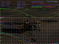
Another attempt at estimating the power generated by the solar panels. Mike's links clarified the cell efficiency and confirmed that the panel area is 4.2M^2 so it now appears that Phoenix started off generating almost 3.5 kWatt Hours per Sol. The only major variable I'm not accounting for is the conversion efficiency of the power management system which I'm assuming is 80% but that is just a guess.
I dropped in a variant of jmknapps solar elevation chart in aswell - I thought it was a nice way to see the link between the sun's change in elevation and the drop off in power. Temperature would be a neat component to add now - anyone know of an easy way to approximate\estimate the change in surface temperature given that I have the overall rate of change in insolation? I'm having some trouble getting my head around thermal inertia so any pointers would be welcome.
|
|
|
|
|
|
|
Jun 6 2008, 11:56 PM
Post
#22
|
|
|
Senior Member Group: Members Posts: 2530 Joined: 20-April 05 Member No.: 321 |
QUOTE (helvick @ Jun 6 2008, 04:43 PM) Temperature would be a neat component to add now - anyone know of an easy way to approximate\estimate the change in surface temperature given that I have the overall rate of change in insolation? I'm having some trouble getting my head around thermal inertia so any pointers would be welcome. TES provided some "ground truthing" as did the Vikings and Pathfinder. Roughly speaking, you can assume a phase shift between insolation and temperature, and from Pathfinder, it looks like it's about 3 hours during daylight and 10 hours during the night. A key factor is: Which temperature do we care about? Pathfinder showed a difference based upon very slight difference in altitude. We probably don't care if the footpads are at absolute zero but rather about the instrument deck, and with Pathfinder, the difference was small at night but about 6C in the afternoon. The actual instruments may experience a nanoclimate based upon the reflectance of the craft (as opposed to the Pathfinder sensors). Basically, I think TES will hand you the answers. It was scanning a full line of longitude every day. This data ought to already be on the books. Pathfinder can let you map surface temperatures onto "1 meter" temperatures. |
|
|
|
|
Jun 7 2008, 04:17 PM
Post
#23
|
|
 Member Group: Members Posts: 150 Joined: 3-June 08 From: McLean, VA Member No.: 4177 |
(A Newbie's first post.. yay)
I'm doing a painting of Phoenix on the surface at midnight - the view will be from the Northwest looking Southeast, so a good bit of it will be looking nearly down-sun. I was really hoping that we would have gotten the midnight "Holy Cow!" shot by now so there would be something to get a sense of what low sun, down-sun looks like on Mars. I have trolled the MER pancam shots but haven't found anything relevant yet, nor have I found that one picture I've seen (probably from a Haz Cam?) with the shadow of the rover extending far out in front. Is there a group that is interested in the low-sun/sunrise look of the surface? I have seen some cool stuff of what the sun looks like rising (from Viking as well as MER) but nothing looking the other way. The sun elevation graph here is really helpful, which is why I'm posting to this thread. (This whole enterprise (UMSF) is incredibly useful and interesting!). I'll post a pic of my work when it is done if that's appropriate. Thanks! Paul |
|
|
|
| Guest_Zvezdichko_* |
Jun 7 2008, 04:20 PM
Post
#24
|
|
Guests |
I'd like to see a simulated view of a Martian analemma. It's an ellipse (or teardrop) on MPL/Spirit/Oppy site, but what about the Phoenix site?
|
|
|
|
|
Jun 7 2008, 04:24 PM
Post
#25
|
|
|
Founder Group: Chairman Posts: 14432 Joined: 8-February 04 Member No.: 1 |
Mars 24 will do that for you.
Doug |
|
|
|
| Guest_Zvezdichko_* |
Jun 7 2008, 04:32 PM
Post
#26
|
|
Guests |
Great, thank you Doug, I found that option!
|
|
|
|
|
Jun 7 2008, 05:00 PM
Post
#27
|
|
 Senior Member Group: Members Posts: 4247 Joined: 17-January 05 Member No.: 152 |
QUOTE (Zvezdichko @ Jun 7 2008, 04:20 PM) I'd like to see a simulated view of a Martian analemma. It's an ellipse (or teardrop) on MPL/Spirit/Oppy site, but what about the Phoenix site? It should be exactly the same shape as viewed from anywhere on Mars, just lower or higher in the sky (and inverted as viewed from the southern hemisphere relative to the northern view). |
|
|
|
| Guest_Zvezdichko_* |
Jun 7 2008, 05:09 PM
Post
#28
|
|
Guests |
QUOTE (fredk @ Jun 7 2008, 05:00 PM) It should be exactly the same shape as viewed from anywhere on Mars, just lower or higher in the sky (and inverted as viewed from the southern hemisphere relative to the northern view). my confusion was because the sun never sets during the summer and it's complete darkness during the winter. We expect to see a partial ellipse. |
|
|
|
|
Jun 7 2008, 05:12 PM
Post
#29
|
|
|
Senior Member Group: Members Posts: 4247 Joined: 17-January 05 Member No.: 152 |
QUOTE (Paul Fjeld @ Jun 7 2008, 04:17 PM) ... nor have I found that one picture I've seen (probably from a Haz Cam?) with the shadow of the rover extending far out in front. You may be thinking of this famous shot at Endurance: http://marsrovers.jpl.nasa.gov/gallery/all...52P1214L0M1.JPG There was also a similar shot from just inside Vicoria: http://marsrovers.jpl.nasa.gov/gallery/all...00P1156L0M1.JPG I can't think of any more looking-away-from-the-low-sun shots at the moment... I'd love to see your result when it's done... |
|
|
|
|
Jun 7 2008, 05:33 PM
Post
#30
|
|
|
Senior Member Group: Members Posts: 4247 Joined: 17-January 05 Member No.: 152 |
QUOTE (Zvezdichko @ Jun 7 2008, 05:09 PM) my confusion was because the sun never sets during the summer and it's complete darkness during the winter. We expect to see a partial ellipse. The analemma drops lower as you move north (but keeps its shape). Once you cross the arctic circle, the bottom of the analemma dips below the horizon. By the time you get to the north pole, you can see only the upper half of the analemma. All of this is observing at local noon. At other times of day you'd see even less of the analemma. Gee, with all the clear skies on Mars, it would be quite easy to do one of those one-photograph-a-week analemma shots... |
|
|
|
|

|
Lo-Fi Version | Time is now: 25th May 2024 - 10:15 PM |
|
RULES AND GUIDELINES Please read the Forum Rules and Guidelines before posting. IMAGE COPYRIGHT |
OPINIONS AND MODERATION Opinions expressed on UnmannedSpaceflight.com are those of the individual posters and do not necessarily reflect the opinions of UnmannedSpaceflight.com or The Planetary Society. The all-volunteer UnmannedSpaceflight.com moderation team is wholly independent of The Planetary Society. The Planetary Society has no influence over decisions made by the UnmannedSpaceflight.com moderators. |
SUPPORT THE FORUM Unmannedspaceflight.com is funded by the Planetary Society. Please consider supporting our work and many other projects by donating to the Society or becoming a member. |
|