Sol 22 and after, Digging in Wonderland |

  |
Sol 22 and after, Digging in Wonderland |
 Jun 21 2008, 09:05 PM Jun 21 2008, 09:05 PM
Post
#46
|
||
|
Newbie  Group: Members Posts: 8 Joined: 4-June 08 Member No.: 4181 |
QUOTE (robspace54 @ Jun 18 2008, 08:02 PM)  Didn't they identify olivine in the material sprinkeld onto the microscope? And the material can appear green It is posible that the olivine is in this layer to .
Attached thumbnail(s)
|
|
 |
 
|
|
|
Jun 21 2008, 09:09 PM
Post
#47
|
|
|
Member Group: Members Posts: 191 Joined: 20-November 06 From: Saint Louis Member No.: 1376 |
I didn't hear that they *confirmed* olivine, just that some of the particles *looked like* and therefore very well could be olivine.
-------------------- - Matt
|
|
|
|
|
Jun 21 2008, 10:31 PM
Post
#48
|
|
 Senior Member Group: Members Posts: 3648 Joined: 1-October 05 From: Croatia Member No.: 523 |
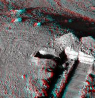
Sol 26 look:
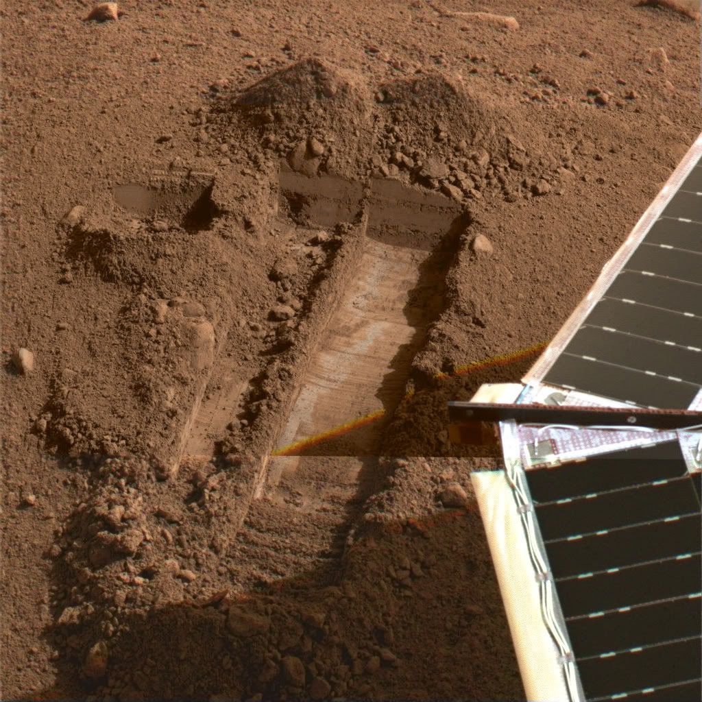 Merged subframe at full color with full frame at 1/4 res color and single red full res frame. Lander shadow moved quite a bit causing discontinuities. -------------------- |
|
|
|
|
Jun 22 2008, 02:54 AM
Post
#49
|
||
 Senior Member Group: Members Posts: 4256 Joined: 17-January 05 Member No.: 152 |
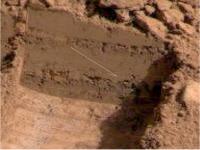
Sol 25 Wonderland trench under late afternoon (almost 6pm) light.
|
|
|
|
|
|
|
Jun 22 2008, 04:02 AM
Post
#50
|
||||
|
Solar System Cartographer Group: Members Posts: 10226 Joined: 5-April 05 From: Canada Member No.: 227 |
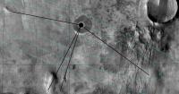
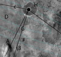
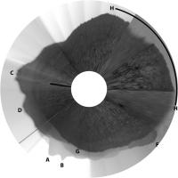
Mods - move this if you want it somewhere else...
I took my circular version of the panorama, posted earlier, and laid it over Tim Parker's map at the best estimate location.
Then I used sight lines to hills to see which features we see on the horizon. The common features are labelled below.
-------------------- ... because the Solar System ain't gonna map itself.
Also to be found posting similar content on https://mastodon.social/@PhilStooke Maps for download (free PDF: https://upload.wikimedia.org/wikipedia/comm...Cartography.pdf NOTE: everything created by me which I post on UMSF is considered to be in the public domain (NOT CC, public domain) |
|||
|
|
|
|||
|
Jun 22 2008, 04:10 AM
Post
#51
|
||
|
Solar System Cartographer Group: Members Posts: 10226 Joined: 5-April 05 From: Canada Member No.: 227 |
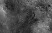
That puts the site about here, to put it in context.
Phil
-------------------- ... because the Solar System ain't gonna map itself.
Also to be found posting similar content on https://mastodon.social/@PhilStooke Maps for download (free PDF: https://upload.wikimedia.org/wikipedia/comm...Cartography.pdf NOTE: everything created by me which I post on UMSF is considered to be in the public domain (NOT CC, public domain) |
|
|
|
|
|
|
Jun 22 2008, 09:45 AM
Post
#52
|
||
 The Poet Dude Group: Moderator Posts: 5551 Joined: 15-March 04 From: Kendal, Cumbria, UK Member No.: 60 |
Sol 26 Wonderland trench... lots of detail visible...
-------------------- |
|
|
|
|
|
|
Jun 22 2008, 10:11 AM
Post
#53
|
|
 Senior Member Group: Members Posts: 1729 Joined: 3-August 06 From: 43° 35' 53" N 1° 26' 35" E Member No.: 1004 |
QUOTE (Stu @ Jun 22 2008, 11:45 AM) Sol 25 Wonderland trench... amazing! |
|
|
|
|
Jun 22 2008, 12:17 PM
Post
#54
|
|
|
Member Group: Members Posts: 163 Joined: 16-March 05 From: Oakville, Ontario, Canada Member No.: 201 |
Can't wait for them to start digging deeper. Any ideas on how deep they would like to go?
The layering in the trench should be interesting if they are able to dig deep. I hope everyone is receiving twitters from the lander. Soon to be ranked 7th on the twitterholic page. Number 4 seems doable  JB |
|
|
|
|
Jun 23 2008, 05:31 AM
Post
#55
|
|
 Senior Member Group: Members Posts: 2228 Joined: 1-December 04 From: Marble Falls, Texas, USA Member No.: 116 |
QUOTE (jabe @ Jun 22 2008, 07:17 AM) Can't wait for them to start digging deeper. Any ideas on how deep they would like to go? ... That's an easy one.  They surely would want to dig as deeply as possible, as that would likely provide the longest line of geological/climatalogical history at this location. But then we would want to study that vertical section in context, requiring additional lateral excavations. They surely would want to dig as deeply as possible, as that would likely provide the longest line of geological/climatalogical history at this location. But then we would want to study that vertical section in context, requiring additional lateral excavations. I get the impression that the concern here is about a shallow ice table that might prevent digging deeply, thus the earlier suggestion that Phoenix might need to strip mine the national parks, to at least expose the topography of this local ice table. I suspect deeply-digging might be easier near the polygon boundaries, but I am not sure how those boundaries align with the digging degrees of freedom of the robotic arm. I can't wait to see what Phoenix does next... -------------------- ...Tom
I'm not a Space Fan, I'm a Space Exploration Enthusiast. |
|
|
|
|
Jun 23 2008, 06:11 AM
Post
#56
|
|
|
Member Group: Members Posts: 191 Joined: 20-November 06 From: Saint Louis Member No.: 1376 |
Ok, this brings up a question I've had for a while now which I may as well ask at the risk of sounding like an ignoramus.
 Do we know how deep this ice layer should be? Do we have MEX or MRO data from their radars about this? I know there were press releases from MRO (I think) that showed an image produced by SHARAD of the north polar region, but it didn't really elaborate on what we were seeing. Do we know how deep this ice layer should be? Do we have MEX or MRO data from their radars about this? I know there were press releases from MRO (I think) that showed an image produced by SHARAD of the north polar region, but it didn't really elaborate on what we were seeing. Anyone have any more insight into this? -------------------- - Matt
|
|
|
|
|
Jun 23 2008, 06:24 AM
Post
#57
|
|
 Member Group: Members Posts: 568 Joined: 20-April 05 From: Silesia Member No.: 299 |
Sol 027: Exit safe mode ???
-------------------- Free software for planetary science (including Cassini Image Viewer).
http://members.tripod.com/petermasek/marinerall.html |
|
|
|
|
Jun 23 2008, 07:30 AM
Post
#58
|
|
|
Senior Member Group: Members Posts: 3648 Joined: 1-October 05 From: Croatia Member No.: 523 |
Yes, what's with no images received on sol 27?
-------------------- |
|
|
|
|
Jun 23 2008, 10:08 AM
Post
#59
|
|
 Forum Contributor Group: Members Posts: 1374 Joined: 8-February 04 From: North East Florida, USA. Member No.: 11 |
Lemmons caption says they went into Safemode....
Sol 027: Exit safe mode (was: WCL test, remote sensing, hold sample for WCL) |
|
|
|
|
Jun 23 2008, 10:14 AM
Post
#60
|
|
|
Senior Member Group: Members Posts: 3648 Joined: 1-October 05 From: Croatia Member No.: 523 |
I somehow missed that bit. It seems that after a near-perfect landing at a perfect location they've been having quite a bit of trouble ever so often, regardless be it with orbital or ground assets. Hope it's just a pesky cosmic ray hit this time.
-------------------- |
|
|
|
|

|
Lo-Fi Version | Time is now: 23rd September 2024 - 04:01 PM |
|
RULES AND GUIDELINES Please read the Forum Rules and Guidelines before posting. IMAGE COPYRIGHT |
OPINIONS AND MODERATION Opinions expressed on UnmannedSpaceflight.com are those of the individual posters and do not necessarily reflect the opinions of UnmannedSpaceflight.com or The Planetary Society. The all-volunteer UnmannedSpaceflight.com moderation team is wholly independent of The Planetary Society. The Planetary Society has no influence over decisions made by the UnmannedSpaceflight.com moderators. |
SUPPORT THE FORUM Unmannedspaceflight.com is funded by the Planetary Society. Please consider supporting our work and many other projects by donating to the Society or becoming a member. |
|