Titan's Equatorial Sand Seas |

  |
Titan's Equatorial Sand Seas |
 Aug 23 2008, 01:34 AM Aug 23 2008, 01:34 AM
Post
#361
|
|
 Member  Group: Members Posts: 611 Joined: 23-February 07 From: Occasionally in Columbia, MD Member No.: 1764 |
QUOTE (Juramike @ Aug 22 2008, 01:52 AM)  Pseudocolorized ISS + T3 RADAR of region near Menrva Crater. ...... The "dog bone" shape one crater diameter to the ESE of Menrva can be seen to be an ISS dark and RADAR dark streaky dune sand basin with bright islands. Beautiful product, Mike The 'dog bone' (I think at the time we called it a 'lobster'!) was one of the first, strongest correlations of ISS-dark and radar-dark (and thus ultimately dunes) we saw, way back in 2005 |
 |
 
|
|
Aug 24 2008, 04:56 AM
Post
#362
|
|||
 Senior Member Group: Moderator Posts: 2785 Joined: 10-November 06 From: Pasadena, CA Member No.: 1345 |
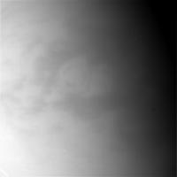
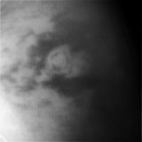
A nice view of Menrva was seen on the most recent non-targeted flyby on August 15, 2008.
Here is the original image (N00118617.jpg):
And here is the image after I played with contrast-stretching the heck out of it (and noise despeckled, etc.):
-Mike (I think this might be a better image of Menrva than the one from the Oct. 2007 Titan map.) -------------------- Some higher resolution images available at my photostream: http://www.flickr.com/photos/31678681@N07/
|
||
|
|
|
||
|
Aug 24 2008, 05:39 AM
Post
#363
|
|
 Senior Member Group: Moderator Posts: 3233 Joined: 11-February 04 From: Tucson, AZ Member No.: 23 |
It is. Already added the frame to my new map. Not sure when it might get released.
-------------------- &@^^!% Jim! I'm a geologist, not a physicist!
The Gish Bar Times - A Blog all about Jupiter's Moon Io |
|
|
|
|
Aug 25 2008, 03:50 AM
Post
#364
|
|
|
Senior Member Group: Moderator Posts: 2785 Joined: 10-November 06 From: Pasadena, CA Member No.: 1345 |
QUOTE (rlorenz @ Aug 22 2008, 09:34 PM) The 'dog bone' (I think at the time we called it a 'lobster'!) was one of the first, strongest correlations of ISS-dark and radar-dark (and thus ultimately dunes) we saw, way back in 2005 There are themes of funky shapes that keep repeating on Titan's surface. The "dog bone" or "lobster claws" shapes are common occurrences. These caudal shapes [fish-tail shaped, so about halfway between lobster and mammal] are usually ISS dark and RADAR-dark. I've been using them to help match up ISS and RADAR views. They can be seen in T8-Adiri, T3-near Menrva as you mentioned, and T23-Fensal/Quivira/Aaru, and T8-Senkyo. The shape is usually oriented downwind (as if the fish was swimming into the wind.) I suspect the caudate shapes form when a headland juts out and dune sands are pushed around the object only to get finally beached downwind from the promotory. Another shape that recurs, and is related to the caudal shapes, are shapes that look like the feathers on an arrow. These are usually symmetrical, and look like a caudal shape except they are split in two by a bright feature. They are also ISS dark and RADAR dark. These also point upwind (as if the arrow were being shot into the wind). T8-Adiri has several of these. There are also some seen in the ISS in NE Shangri-La and in some of the graben of Tseghi, and also in Bakab Virgae. I suspect the arrow-feather-shapes ("flechal shapes?") form when there is a N-S undulation (broad graben) that is split by an EW tectonic ridge. Dune sands (or ice sands) get trapped in the local basin. Yet another shape is an arrow-head shape. These point downwind. The Huygens Landing site on E Adiri is right at the tip of one of these, Sotra Facula also has an arrow-head shaped ice sand shelf. And there are several others seen in the ISS images near Belet and Senkyo. (I'm really looking forward to future RADAR Swaths in here). I think they are composed of either bright terrain, rotten terrain, or dark blue ice sand bordered by dune sands. And then of course are those weird oval blobby shapes (sometime polygonal) that are surrounded by a thin dark lane. And then the bullet-shaped blobby bright islands. These seem to be in every sand sea basin. Interestingly, I really haven't seen any of these shapes beyond the Equatorial/Low temperate zones. While I can't explain exactly what these shapes signify, they've been extremely useful for matching up the RADAR and ISS images. -Mike -------------------- Some higher resolution images available at my photostream: http://www.flickr.com/photos/31678681@N07/
|
|
|
|
|
Aug 25 2008, 03:55 AM
Post
#365
|
||
|
Senior Member Group: Moderator Posts: 2785 Joined: 10-November 06 From: Pasadena, CA Member No.: 1345 |
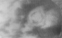
Here is a blink gif showing an overlay of T3 RADAR Swath onto a heavily modified [multiple contrast gradients, despeckled] version of the August 15 image N00118617 centerd on Menrva.
(The overlay is lined up best with Menrva, westwards it's slightly off.) I'm totally amazed at how much detail can be observed in the ISS image and how well it matches up to the RADAR features. -Mike -------------------- Some higher resolution images available at my photostream: http://www.flickr.com/photos/31678681@N07/
|
|
|
|
|
|
|
Aug 27 2008, 04:52 AM
Post
#366
|
||
|
Senior Member Group: Moderator Posts: 2785 Joined: 10-November 06 From: Pasadena, CA Member No.: 1345 |
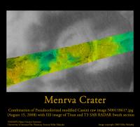
T3 RADAR Swath of Menrva with pseudocolorized and modified N0018617 base image:
-Mike -------------------- Some higher resolution images available at my photostream: http://www.flickr.com/photos/31678681@N07/
|
|
|
|
|
|
|
Aug 27 2008, 06:08 PM
Post
#367
|
|
|
Member Group: Members Posts: 700 Joined: 1-April 08 From: Minnesota ! Member No.: 4081 |
"I'm totally amazed at how much detail can be observed in the ISS image and how well it matches up to the RADAR features. " Awesome animated gif Mike, and how true what ISS can show with some tweaking. However the SAR-ISS match up also shows how wise it was to have multiple 'imaging' modalities on Cassini. One would (I at least) be hard-pressed to see the fascinating dunes and the braided channels if ISS was all we had to scrutinize on the flyby's. When a process roughs up or smooths out the topography SAR's higher resolution really shines. |
|
|
|
|
Aug 27 2008, 07:07 PM
Post
#368
|
|
|
Senior Member Group: Moderator Posts: 3233 Joined: 11-February 04 From: Tucson, AZ Member No.: 23 |
You make it sound like ISS has never seen dunes or braided channels
 
-------------------- &@^^!% Jim! I'm a geologist, not a physicist!
The Gish Bar Times - A Blog all about Jupiter's Moon Io |
|
|
|
|
Sep 2 2008, 12:53 AM
Post
#369
|
|
|
Member Group: Members Posts: 700 Joined: 1-April 08 From: Minnesota ! Member No.: 4081 |
"You make it sound like ISS has never seen dunes or braided channels" HA! I certainly defer to your expertise on ISS and SAR Volcanopele! I was mainly commenting on the comparision of ISS and SAR in Mike's animated gif image. |
|
|
|
|
Sep 5 2008, 04:16 AM
Post
#370
|
||
|
Senior Member Group: Moderator Posts: 2785 Joined: 10-November 06 From: Pasadena, CA Member No.: 1345 |
The combination of RADAR and ISS images is really, really powerful. I was amazed that some of the ISS patches matched up so well with some of the SAR RADAR brightness changes.
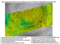
Here's another look at a zoomed section of the Menrva image above, with a few key features indicated and my captioned interpretations.
ISS bright = original crustal stuff (I think), ISS dark = organic dunes or sediments. RADAR bright = rough cliffs or rocks or cobbles; RADAR dark = smooth sediments, muds, or flat sands These can be orthogonal. So RADAR bright/ISS bright material could be steep cliffs or bright rocks of original crustal materials. While RADAR bright/ISS dark material could be rough rocks of a slightly different material (ice sand mantle). In the image (just north of #2) there is an interesting patch of RADAR dark/ISS bright material. (More on this later...) -Mike Regarding channels, In the image above, there are ISS dark (#2), ISS slightly darker (#3), and ISS bright (E of #10, I'll show in a follow-up post) locally correlated to RADAR-bright braided channels. -------------------- Some higher resolution images available at my photostream: http://www.flickr.com/photos/31678681@N07/
|
|
|
|
|
|
|
Jan 8 2009, 02:48 AM
Post
#371
|
||
|
Senior Member Group: Moderator Posts: 2785 Joined: 10-November 06 From: Pasadena, CA Member No.: 1345 |
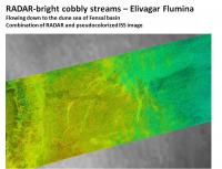
Here is a pseudoclorized image of the braided (=anabranched) channels just to the E of Menrva named Elivagar Flulmina:
The RADAR bright (cobbly, or filled with some sort of roughish deposit?) can be seen flowing across bright highland down to Fensal. Those streams are very wide and RADAR bright, almost reminiscent of glacial outflow streams. (What the heck is going on there? Where is all the liquid coming from? It appears to be percolating out of the Menrva debris field? And what are the deposits made of? Are they coming up from the ground downstream of Menrva? Is Menrva acting like a big coffee filter and this is the continuation of the stream drainages coming into the crater?) -------------------- Some higher resolution images available at my photostream: http://www.flickr.com/photos/31678681@N07/
|
|
|
|
|
|
|
Jan 8 2009, 02:56 AM
Post
#372
|
||
|
Senior Member Group: Moderator Posts: 2785 Joined: 10-November 06 From: Pasadena, CA Member No.: 1345 |
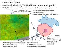
Here is a pseudocoloized image + annotation of the dome feature inside Menrva crater:
The stream that breaches the Menrva crater wall at the SW corner appears to curve around this feature when it enters the interior of the crater. The dark deposit (ISS dark and RADAR smooth) inside the crater also appears to curve around this feature. Both of these are consistent with this feature being a dome ). There appears to be a RADAR-bright edge at the top which gives the impression of a flat topped shield or crater at the summit. I think this is one of the better candidates for a shield cryovolcano on Titan. His buddy, a similar but smaller dome to the W of Menrva was already discussed here (Titan topics @ AGU2008, post #24). -------------------- Some higher resolution images available at my photostream: http://www.flickr.com/photos/31678681@N07/
|
|
|
|
|
|
|
Jan 8 2009, 03:59 AM
Post
#373
|
||
|
Senior Member Group: Moderator Posts: 2785 Joined: 10-November 06 From: Pasadena, CA Member No.: 1345 |
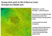
And then there is that interesting RADAR dark/ISS bright patch just north of #2 in the pseudocolorized Menrva image:
RADAR dark implies smooth (or different dielectric constant or volume scattering). (The brightness temperature from Paginelli et al, Icarus, 2007 shows this is cooler, consistent with high volume scattering materials or higher dielectric materials, in fact, it looks the same temperature as Elivagar Flumina) But the ISS shows this to be the same IR reflectivity as the surrounding terrain. The drainage pattern looks very regular (straight and dendritic) with a drainage to the SE. All of this is consistent with a smooth localized deposit of material across a flat-floored basin that tilts to the SE. [Infilled then tilted crater? Smooth airfall deposit dust trap? Could this be a junior version of Ganesa Macula?] -Mike A high res version of the Menrva pseudocolorized image is available here: http://www.flickr.com/photos/31678681@N07/3178891550/ A larger version of the pseudocolorized T3 SAR RADAR image without the ISS basemap is available here: http://www.flickr.com/photos/31678681@N07/3178062013/ -------------------- Some higher resolution images available at my photostream: http://www.flickr.com/photos/31678681@N07/
|
|
|
|
|
|
|
Jan 8 2009, 01:01 PM
Post
#374
|
||
|
Senior Member Group: Moderator Posts: 2785 Joined: 10-November 06 From: Pasadena, CA Member No.: 1345 |
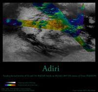
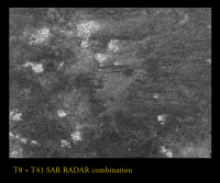
Adiri pseudocolorized overlay of ISS and the T8 and T41 SAR RADAR Swaths:
The intersection of the ISS image with the SAR RADAR swaths was pseudocolorized according to ISS brightness. To adjust for some distortion in the T41 RADAR Swath, the lower section of the T41 Swath was selected: this selected region was from the southern edge of the T8 Swath to the lower end of the T41 Swath. Using the Distort function in Photoshop with a gentle nudge lined up the SE archipelago of Adiri as well as the islands in the Ching-Tu basin. A higher resolution (ca. 59.3%, or 152 pix/degree, ca. 300 m/pixel) version is available here (3 Mb JPEG): http://www.flickr.com/photos/31678681@N07/3177773885/ -Mike -------------------- Some higher resolution images available at my photostream: http://www.flickr.com/photos/31678681@N07/
|
|
|
|
|
|
|
Jan 11 2009, 03:43 AM
Post
#375
|
||
|
Senior Member Group: Moderator Posts: 2785 Joined: 10-November 06 From: Pasadena, CA Member No.: 1345 |
Ahhhh, the beauty of coordinated images!
Here is a blink of the Flower Petal Crater (located ca. 100 km WNW of the Huygens landing site, and 50 km to the E of the 150 km craterform identified by Rodriguez et al. It is pefectly coordinated. The Petals are correlated, but there are other features that are anti-correlated.
(click to animate) The blink is of the combined T8 and T41 SAR RADAR swaths (at full res) compare/contrasted with the ISS[0.93 um] image. The Flower Petal Crater was identified as an "eroded crater" in a much earlier discussion. (It's is also a handy feature for coordinating images). The "petals" are also visible in the ISS image and line up perfectly in the image. Now here's a big surprise: Just to the S of the Flower petal crater there is a RADAR-dark zone that correlates to an ISS-bright zone. This combination is pretty rare on Titan in the Equatorial zones. It implies a smooth but IR-reflective surface. Extending to the SSE there is what could be a lobate flow of RADAR-dark/ISS-bright material. We've seen stuff like this before: This looks very similar to the dark flow-like feature seen in E Xanadu in the T13 swath!! The VIMS spectra showed it to be more "organic-like" rather than "ice-like". Is this related??? Is that ISS-bright blob the source of the RADAR-dark flow??? (Oh yeah, note the RADAR-bright streambed crossing the RADAR dark flow, but avoiding the ISS-brightest patch. Just like in E Xanadu!) -Mike -------------------- Some higher resolution images available at my photostream: http://www.flickr.com/photos/31678681@N07/
|
|
|
|
|
|
|

|
Lo-Fi Version | Time is now: 27th May 2024 - 10:57 AM |
|
RULES AND GUIDELINES Please read the Forum Rules and Guidelines before posting. IMAGE COPYRIGHT |
OPINIONS AND MODERATION Opinions expressed on UnmannedSpaceflight.com are those of the individual posters and do not necessarily reflect the opinions of UnmannedSpaceflight.com or The Planetary Society. The all-volunteer UnmannedSpaceflight.com moderation team is wholly independent of The Planetary Society. The Planetary Society has no influence over decisions made by the UnmannedSpaceflight.com moderators. |
SUPPORT THE FORUM Unmannedspaceflight.com is funded by the Planetary Society. Please consider supporting our work and many other projects by donating to the Society or becoming a member. |
|