Endeavour Drive - Drivability analysis |

  |
Endeavour Drive - Drivability analysis |
 Sep 27 2008, 10:30 PM Sep 27 2008, 10:30 PM
Post
#376
|
||||
 Senior Member  Group: Moderator Posts: 2785 Joined: 10-November 06 From: Pasadena, CA Member No.: 1345 |
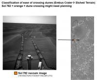
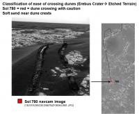
Now working towards the Etched Terrain.
In some cases I added the Navcam view looking directly towards the dunes to try to estimate their waviness.
-------------------- Some higher resolution images available at my photostream: http://www.flickr.com/photos/31678681@N07/
|
|||
 |
 
|
|||
|
Sep 27 2008, 10:35 PM
Post
#377
|
||||
|
Senior Member Group: Moderator Posts: 2785 Joined: 10-November 06 From: Pasadena, CA Member No.: 1345 |
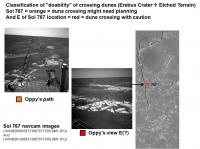
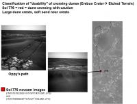
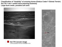
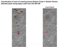
Sol 778 and 780 classifications and Navcam images:
And putting it all together and overlaying on the Erebus Crater to Etched Terrain test HiRise image:
I'll use this for the "Ground Truth" to compare all the next generation of processing techniques. -Mike -------------------- Some higher resolution images available at my photostream: http://www.flickr.com/photos/31678681@N07/
|
|||
|
|
|
|||
|
Sep 28 2008, 12:02 AM
Post
#378
|
|
|
Senior Member Group: Moderator Posts: 2785 Joined: 10-November 06 From: Pasadena, CA Member No.: 1345 |
Anybody know if there's are links available to hi-res HiRise jpegs of the areas between Victoria and Endeavour?
A little more tweaking and I'll be ready to play.... -Mike -------------------- Some higher resolution images available at my photostream: http://www.flickr.com/photos/31678681@N07/
|
|
|
|
|
Sep 28 2008, 12:32 AM
Post
#379
|
|
|
Member Group: Members Posts: 104 Joined: 1-June 08 Member No.: 4172 |
Here's a crazy, far-fetched idea that just might work: Most of the area in question (Victoria to Mini Endurance) is covered by not one, but two HiRISE images. Chances are, they were taken from slightly different orbital positions, so overlaying them, taking the difference, and applying a Fourier analysis to what is essentially a high-resolution map of small-scale elevation changes should give a result that actually reflects what is the toughest part of these dunes: their height, not their length or width. All this is just a guess, though. First, everyone could try remapping their color gradients to Juramike's ground truth color values.
On hires JPEGs, that's exactly what I'm looking for, too. Maybe Emily will be nice enough to provide them again? 
|
|
|
|
|
Sep 28 2008, 12:49 AM
Post
#380
|
|
|
Member Group: Admin Posts: 976 Joined: 29-September 06 From: Pasadena, CA - USA Member No.: 1200 |
QUOTE (jekbradbury @ Sep 27 2008, 04:32 PM)  Here's a crazy, far-fetched idea that just might work: Most of the area in question (Victoria to Mini Endurance) is covered by not one, but two HiRISE images. Chances are, they were taken from slightly different orbital positions, so overlaying them, taking the difference, and applying a Fourier analysis to what is essentially a high-resolution map of small-scale elevation changes should give a result that actually reflects what is the toughest part of these dunes: their height, not their length or width. All this is just a guess, though. First, everyone could try remapping their color gradients to Juramike's ground truth color values. On hires JPEGs, that's exactly what I'm looking for, too. Maybe Emily will be nice enough to provide them again? Not a crazy idea at all. DEMs Digital elevation models) from those multiple passes have been computed, and it is not at all a trivial matter. Unfortunately the best that can be done in elevation is an accuracy of about one foot. That is unfortunately insufficient for reliably finding a good spot to cross ripples or finding their size. If they are 1 meter tall you can immediately tell from visual (or automated) inspection of the HiRISE image. Paolo -------------------- Disclaimer: all opinions, ideas and information included here are my own,and should not be intended to represent opinion or policy of my employer.
|
|
|
|
|
Sep 28 2008, 12:56 AM
Post
#381
|
||||
|
Member Group: Admin Posts: 976 Joined: 29-September 06 From: Pasadena, CA - USA Member No.: 1200 |
QUOTE (Juramike @ Sep 27 2008, 02:35 PM) Sol 778 and 780 classifications and Navcam images:
And putting it all together and overlaying on the Erebus Crater to Etched Terrain test HiRise image:
I'll use this for the "Ground Truth" to compare all the next generation of processing techniques. -Mike Wow, I can't believe you actually went through the trouble of doing this. I DO NOT want to discourage you (or anybody else for that matter) from doing this, but I will have someone at JPL do this analysis because they will be able to also look at the telemetry (I really wish I could involve you in this!). So many sols have gone by and we need to refresh our memory. You guys never cease to amaze me. Paolo -------------------- Disclaimer: all opinions, ideas and information included here are my own,and should not be intended to represent opinion or policy of my employer.
|
|||
|
|
|
|||
|
Sep 28 2008, 01:09 AM
Post
#382
|
||
|
Member Group: Members Posts: 104 Joined: 1-June 08 Member No.: 4172 |
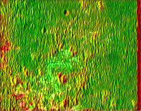
The "DEM" method has some promise:
Instead of trying to get a six-inch accuracy map of each dune, it simply looks at the average "height" within a 25-pixel radius and compares it to the average "height" within a 100-pixel radius. This is because the elevation actually changes significantly across the image (it's the edge of the ejecta blanket) and would mess up the colors. |
|
|
|
|
|
|
Sep 28 2008, 01:12 AM
Post
#383
|
|
 Senior Member Group: Members Posts: 1887 Joined: 20-November 04 From: Iowa Member No.: 110 |
QUOTE (RoverDriver @ Sep 27 2008, 07:49 PM) Not a crazy idea at all. DEMs Digital elevation models) from those multiple passes have been computed, and it is not at all a trivial matter. Unfortunately the best that can be done in elevation is an accuracy of about one foot. That is unfortunately insufficient for reliably finding a good spot to cross ripples or finding their size. If they are 1 meter tall you can immediately tell from visual (or automated) inspection of the HiRISE image. Paolo Are the DEM's accurate enough to detect the change in elevation mentioned here QUOTE Opportunity's Sol 446 Position, with Relative Heights http://marsrovers.jpl.nasa.gov/gallery/pre.../20050506b.htmlThis mosaic of navigation-camera frames from NASA's Mars Exploration Rover Opportunity, presented in a vertical projection, shows the rover's position after it dug itself to wheel-hub depth in a small dune during its 446th martian day, or sol (April 26, 2005). The colors are coding for information about relative elevations in the surrounding area. Red areas are the highest in the image, green areas the lowest. The difference between red and green is about 70 centimeters (28 inches). I'm still concerned about the fish scale pattern beyond the etched terrain south of Victoria representing larger scale drifts underlying the more obvious ripples. The drift Oppy got stuck in at Purgatory was on top of one of these, see the attachment to Pando's post made at the time. http://www.unmannedspaceflight.com/index.p...ost&p=11840 |
|
|
|
|
Sep 28 2008, 02:37 AM
Post
#384
|
|
|
Member Group: Admin Posts: 976 Joined: 29-September 06 From: Pasadena, CA - USA Member No.: 1200 |
QUOTE (alan @ Sep 27 2008, 05:12 PM) Are the DEM's accurate enough to detect the change in elevation mentioned here http://marsrovers.jpl.nasa.gov/gallery/pre.../20050506b.html Not really. But now, after purgatory we have a new FSW (flight software) that can alert the rover it is potentially stuck in sand. When Opportunity was in what you guys have called the "Quackmire" the rover successfully detected it was stuck. That was sort of unfortunate since we were trying to get unstuck  . Therefore, even in the case the rover slams in one of these purgatory stye ripples the rover should stop before it gets too deep into trouble. . Therefore, even in the case the rover slams in one of these purgatory stye ripples the rover should stop before it gets too deep into trouble.QUOTE I'm still concerned about the fish scale pattern beyond the etched terrain south of Victoria representing larger scale drifts underlying the more obvious ripples. The drift Oppy got stuck in at Purgatory was on top of one of these, see the attachment to Pando's post made at the time. http://www.unmannedspaceflight.com/index.p...ost&p=11840 You are correct in identifying the "fish scale pattern" with purgatory-style ripples. Fortunately they are clearly visible in HiRISE. If we are able to precisely localize the rover in that area, it might slow down the per-sol progress, but it should not be considered a threat to the rover. I'm moderately optimistic. Paolo -------------------- Disclaimer: all opinions, ideas and information included here are my own,and should not be intended to represent opinion or policy of my employer.
|
|
|
|
|
Sep 28 2008, 02:59 AM
Post
#385
|
||
|
Member Group: Members Posts: 808 Joined: 10-October 06 From: Maynard Mass USA Member No.: 1241 |
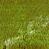
I have been watching this thread with great interest and little time.
But then it happened. My 'honey do list' were canceled due to a hurricane warning (Cat 1 Kyle) approaching the area. We are all battened down (outside Boston MA) and I had a few hours to devote to this task. I am using a quick and dirty DEM approach. Each one-dimensional strip crosses the 'mostly' north-south oriented dunes. Using the brightness and knowledge of the Sun angle I can keep a running pixel-by-pixel tab (relative) of the elevation. The bedrock is the flat reference and they tend to be flat for many pixels (compared to dune peaks). Long brightening dune faces give me 'height' and the darkened sides(shadow) give me the height down. I then plot a running average of height and find the 'driveable spaces' between dunes. I am aware that there are field of landmines with the technique. and I am only on Version 0.001 here is a chunk of the full res Erebus chunk (thanks Emily) and the link below is to flikr (but since I dont have a PRO account it is severely shrunk...sorry) In the full rez chunk, you can see Oppy's tracks... (this chunk) is just north and heading into Erebus. There is also an annoying diagonal line artifact (I have a one off C pointer somewhere). Green is drivable Dark and red is not White is bedrock (and very bright dunes....Version 0.002 is comin') (comment: my map indicates there is a always a drivable 'dune gully' somewhere close. Its just a matter of planning the way forward...like a maze...) 
here is flickr link: http://www.flickr.com/photos/30904379@N07 Cheers! (wow...the rain is coming down sideways!) -------------------- CLA CLL
|
|
|
|
|
|
|
Sep 28 2008, 04:46 AM
Post
#386
|
|
|
Senior Member Group: Members Posts: 1887 Joined: 20-November 04 From: Iowa Member No.: 110 |
QUOTE (RoverDriver @ Sep 27 2008, 09:37 PM) You are correct in identifying the "fish scale pattern" with purgatory-style ripples. Fortunately they are clearly visible in HiRISE. If we are able to precisely localize the rover in that area, it might slow down the per-sol progress, but it should not be considered a threat to the rover. I'm moderately optimistic. Paolo I see most of the algorithms analyzing the terrain aren't flagging them as much as the terrain between Erebus and Victoria, not sure I should see that as good or bad. Hopefully I'm just being paranoid about them, looking back Oppy did get through a significant stretch of the before getting stuck in the last one in her path |
|
|
|
|
Sep 28 2008, 06:38 AM
Post
#387
|
|
|
Senior Member Group: Members Posts: 2922 Joined: 14-February 06 From: Very close to the Pyrénées Mountains (France) Member No.: 682 |
Nice work you all but, you'd better hurry
  : :http://www.unmannedspaceflight.com/index.p...mp;#entry127004 see post #14
-------------------- |
|
|
|
|
Sep 28 2008, 09:40 AM
Post
#388
|
|
|
Founder Group: Chairman Posts: 14432 Joined: 8-February 04 Member No.: 1 |
Changed the name of this thread to reflect what it's really about
|
|
|
|
|
Sep 28 2008, 02:53 PM
Post
#389
|
|
 Senior Member Group: Admin Posts: 4763 Joined: 15-March 05 From: Glendale, AZ Member No.: 197 |
And the next thread we can call "On the Road Again"
On the road again Just can't wait to get on the road again The life I love is makin' music with my friends And I can't wait to get on the road again On the road again Goin' places that I've never been Seein' things that I may never see again, And I can't wait to get on the road again. On the road again Like a band of gypsies we go down the highway We're the best of friends Insisting that the world be turnin' our way And our way Is on the road again Just can't wait to get on the road again The life I love is makin' music with my friends And I can't wait to get on the road again On the road again Like a band of gypsies we go down the highway We're the best of friends Insisting that the world be turnin' our way And our way Is on the road again Just can't wait to get on the road again The life I love is makin' music with my friends And I can't wait to get on the road again And I can't wait to get on the road again Paolo, you'll have to make sure you have a copy of that song cued up when you guys command the first long segment. -------------------- If Occam had heard my theory, things would be very different now.
|
|
|
|
|
Sep 28 2008, 03:55 PM
Post
#390
|
|
|
Senior Member Group: Members Posts: 2922 Joined: 14-February 06 From: Very close to the Pyrénées Mountains (France) Member No.: 682 |
QUOTE (ElkGroveDan @ Sep 28 2008, 04:53 PM) Paolo, you'll have to make sure you have a copy of that song cued up when you guys command the first long segment. You're very funny Dan 153m is by far the longest ever, isn't it ? BTW, nice new avatar. I hope it'll help launching MSL on schedule -------------------- |
|
|
|
|

|
Lo-Fi Version | Time is now: 31st May 2024 - 02:54 AM |
|
RULES AND GUIDELINES Please read the Forum Rules and Guidelines before posting. IMAGE COPYRIGHT |
OPINIONS AND MODERATION Opinions expressed on UnmannedSpaceflight.com are those of the individual posters and do not necessarily reflect the opinions of UnmannedSpaceflight.com or The Planetary Society. The all-volunteer UnmannedSpaceflight.com moderation team is wholly independent of The Planetary Society. The Planetary Society has no influence over decisions made by the UnmannedSpaceflight.com moderators. |
SUPPORT THE FORUM Unmannedspaceflight.com is funded by the Planetary Society. Please consider supporting our work and many other projects by donating to the Society or becoming a member. |
|