Post Solar Conjunction/Santorini Study Drive, The second leg in our Journey to Endeavor Crater |

  |
Post Solar Conjunction/Santorini Study Drive, The second leg in our Journey to Endeavor Crater |
 Jan 1 2009, 03:58 PM Jan 1 2009, 03:58 PM
Post
#31
|
|
 Senior Member  Group: Moderator Posts: 2262 Joined: 9-February 04 From: Melbourne - Oz Member No.: 16 |
And suspiciously named 'pancam_drive_dir_4x1_L2R2' as well.
 Of course just because drive direction images have been taken is no guarantee that we are leaving soon. The view is unlikely to change much however long we stay. 
-------------------- |
 |
 
|
|
Jan 2 2009, 05:40 AM
Post
#32
|
|
|
Member Group: Admin Posts: 976 Joined: 29-September 06 From: Pasadena, CA - USA Member No.: 1200 |
QUOTE (jamescanvin @ Jan 1 2009, 07:58 AM)  And suspiciously named 'pancam_drive_dir_4x1_L2R2' as well. Of course just because drive direction images have been taken is no guarantee that we are leaving soon. The view is unlikely to change much however long we stay. On 1759 we sequenced the ffirst RAT Brush since using the IDD as a 4 DOF arm. There were some questions about the activity and in case we had decided not to go ahead with the brush we would have been ready to drive off instead. Since we did not have drive direction PANCAMs and the NAVCAMS were from the previous location (I know, just less than a meter away) I had requested a set to be ready to drive. I don't know when we will be ready to drive, but I would be surprised to see us drive off in less than a week. Paolo -------------------- Disclaimer: all opinions, ideas and information included here are my own,and should not be intended to represent opinion or policy of my employer.
|
|
|
|
|
Jan 2 2009, 08:27 AM
Post
#33
|
|
|
Merciless Robot Group: Admin Posts: 8784 Joined: 8-December 05 From: Los Angeles Member No.: 602 |
-------------------- A few will take this knowledge and use this power of a dream realized as a force for change, an impetus for further discovery to make less ancient dreams real.
|
|
|
|
|
Jan 2 2009, 05:15 PM
Post
#34
|
|
|
Member Group: Members Posts: 242 Joined: 17-February 04 From: Ohio, USA Member No.: 34 |
nprev,
I couldn't get the link to work, but here's an excerpt from the post: "As Opportunity returned to its normal schedule following solar conjunction, it continued its close-up investigation of Santorini taking measurements with its alpha-particle X-ray spectrometer (APXS) and some close-up pictures with its Micrcoscopic Imager (MI). The cobble, Squyres announced this week, turns out to be another meteorite, a type of stony iron meteorite called a mesosiderite, basically a dead ringer for Santa Catarina and Barberton. You dont see this type of meteorite very often on Earth, but of the four meteorites weve found at Meridiani Planum, three are like this, Squyres pointed out. They are so similar to one another that we suspect they may be pieces of the same thing. |
|
|
|
|
Jan 2 2009, 06:31 PM
Post
#35
|
|
|
Merciless Robot Group: Admin Posts: 8784 Joined: 8-December 05 From: Los Angeles Member No.: 602 |
Oh, my apologies; I screwed up that link copy! This one works.
-------------------- A few will take this knowledge and use this power of a dream realized as a force for change, an impetus for further discovery to make less ancient dreams real.
|
|
|
|
|
Jan 2 2009, 07:50 PM
Post
#36
|
||
|
Solar System Cartographer Group: Members Posts: 10166 Joined: 5-April 05 From: Canada Member No.: 227 |
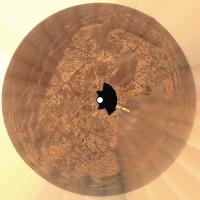
Here's James's recent pan in a polar format with a more map-like geometry than the one posted in the original thread (now closed). North is at the top.
Phil
-------------------- ... because the Solar System ain't gonna map itself.
Also to be found posting similar content on https://mastodon.social/@PhilStooke Maps for download (free PD: https://upload.wikimedia.org/wikipedia/comm...Cartography.pdf NOTE: everything created by me which I post on UMSF is considered to be in the public domain (NOT CC, public domain) |
|
|
|
|
|
|
Jan 2 2009, 07:58 PM
Post
#37
|
||
|
Solar System Cartographer Group: Members Posts: 10166 Joined: 5-April 05 From: Canada Member No.: 227 |
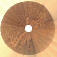
... and another one more stretched out...
Phil
-------------------- ... because the Solar System ain't gonna map itself.
Also to be found posting similar content on https://mastodon.social/@PhilStooke Maps for download (free PD: https://upload.wikimedia.org/wikipedia/comm...Cartography.pdf NOTE: everything created by me which I post on UMSF is considered to be in the public domain (NOT CC, public domain) |
|
|
|
|
|
|
Jan 3 2009, 05:48 AM
Post
#38
|
|
 Senior Member Group: Members Posts: 2228 Joined: 1-December 04 From: Marble Falls, Texas, USA Member No.: 116 |
QUOTE (Phil Stooke @ Jan 2 2009, 01:50 PM) Here's James's recent pan in a polar format with a more map-like geometry than the one posted in the original thread (now closed). North is at the top. Thanks. I liked that one very much. -------------------- ...Tom
I'm not a Space Fan, I'm a Space Exploration Enthusiast. |
|
|
|
|
Jan 4 2009, 04:16 AM
Post
#39
|
||
|
Solar System Cartographer Group: Members Posts: 10166 Joined: 5-April 05 From: Canada Member No.: 227 |
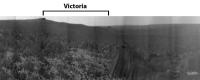
Here's another view derived from James's panorama. This is Victoria, seen with a very large vertical stretch. Old-timers will recall the big debate on UMSF during the approach to Victoria - was the "beacon" (a rock on the top of Cape St. Mary) on the near side or the far side? Parallax soon showed it had to be the near side. But from this perspective we see why it had to be like that. Victoria formed on a slope, so its rim slopes. The near side is significantly higher than the far side.
Phil
-------------------- ... because the Solar System ain't gonna map itself.
Also to be found posting similar content on https://mastodon.social/@PhilStooke Maps for download (free PD: https://upload.wikimedia.org/wikipedia/comm...Cartography.pdf NOTE: everything created by me which I post on UMSF is considered to be in the public domain (NOT CC, public domain) |
|
|
|
|
|
|
Jan 4 2009, 08:32 AM
Post
#40
|
|
|
Senior Member Group: Moderator Posts: 4279 Joined: 19-April 05 From: .br at .es Member No.: 253 |
Great job Phil!
Cape St Mary was clearly visible without stretching but in this view there is enough S/N to distinguish the whole crater from the much further distant terrain. |
|
|
|
| Guest_Zvezdichko_* |
Jan 4 2009, 11:07 AM
Post
#41
|
|
Guests |
|
|
|
|
|
Jan 5 2009, 03:28 AM
Post
#42
|
|
|
Member Group: Members Posts: 233 Joined: 21-April 05 Member No.: 328 |
Darn, Zvezdichko, it's good to see those blueberries again! And maybe not so bad from a scientific standpoint, either -- while it's good, on the one hand, to be able to observe a variety of phenomenon, it's also good -- especially on a world we are exploring for the first time! -- to be able to establish a baseline and have some familiar "landmarks" -- almost like the trail of crumbs that Hansel and Gretel followed!
|
|
|
|
|
Jan 5 2009, 03:54 AM
Post
#43
|
|
 Senior Member Group: Moderator Posts: 2785 Joined: 10-November 06 From: Pasadena, CA Member No.: 1345 |
The blueberries here are a tad puzzling.
From the past discussions, I'd gotten the notion that rock ablation leaves blueberries as residue, then a layer of blueberries armors up the surface and prevents further erosion. So, I woulda thunk that blueberries WOULD NOT be found in areas with big drifts. (Unless maybe the big drifts are frozen and the blueberry armoring has now halted erosion, even if there were stronger winds.) Call me clueless....  -------------------- Some higher resolution images available at my photostream: http://www.flickr.com/photos/31678681@N07/
|
|
|
|
|
Jan 5 2009, 04:42 AM
Post
#44
|
|
|
Solar System Cartographer Group: Members Posts: 10166 Joined: 5-April 05 From: Canada Member No.: 227 |
There might be a few blueberries here, maybe from Victoria ejecta, but many of these chunks are not blueberries. There's quite a range of sizes and shapes.
Phil -------------------- ... because the Solar System ain't gonna map itself.
Also to be found posting similar content on https://mastodon.social/@PhilStooke Maps for download (free PD: https://upload.wikimedia.org/wikipedia/comm...Cartography.pdf NOTE: everything created by me which I post on UMSF is considered to be in the public domain (NOT CC, public domain) |
|
|
|
|
Jan 5 2009, 04:50 AM
Post
#45
|
|
 Senior Member Group: Members Posts: 3419 Joined: 9-February 04 From: Minneapolis, MN, USA Member No.: 15 |
Also, these MIs look suspiciously like the MIs I recall from the dark soils north of Victoria (in the deposition vs. sweeping investigations). Are we certain these are MIs from recent sols? And not just old images being flushed from the flash?
-the other Doug -------------------- The trouble ain't that there is too many fools, but that the lightning ain't distributed right. -Mark Twain
|
|
|
|
|

|
Lo-Fi Version | Time is now: 23rd May 2024 - 02:52 PM |
|
RULES AND GUIDELINES Please read the Forum Rules and Guidelines before posting. IMAGE COPYRIGHT |
OPINIONS AND MODERATION Opinions expressed on UnmannedSpaceflight.com are those of the individual posters and do not necessarily reflect the opinions of UnmannedSpaceflight.com or The Planetary Society. The all-volunteer UnmannedSpaceflight.com moderation team is wholly independent of The Planetary Society. The Planetary Society has no influence over decisions made by the UnmannedSpaceflight.com moderators. |
SUPPORT THE FORUM Unmannedspaceflight.com is funded by the Planetary Society. Please consider supporting our work and many other projects by donating to the Society or becoming a member. |
|