Opportunity Route Map |

  |
Opportunity Route Map |
 Feb 9 2009, 09:42 AM Feb 9 2009, 09:42 AM
Post
#2446
|
|
|
Member  Group: Members Posts: 307 Joined: 16-March 05 Member No.: 198 |
QUOTE (Tesheiner @ Feb 9 2009, 07:46 PM)  Thanks, all. There'll be no problem to keep updating it IF I sort out the way to do it automatically. Quite a long time has passed without exercising my programming skills... If you do does this mean you won't be posting the maps to this thread on UMSF.com any more? ====== Stephen |
 |
 
|
|
Feb 9 2009, 10:07 AM
Post
#2447
|
|
 Special Cookie Group: Members Posts: 2168 Joined: 6-April 05 From: Sintra | Portugal Member No.: 228 |
QUOTE (Stephen @ Feb 9 2009, 09:42 AM) If you do does this mean you won't be posting the maps to this thread on UMSF.com any more? Heresy!   -------------------- "Ride, boldly ride," The shade replied, "If you seek for Eldorado!"
Edgar Alan Poe |
|
|
|
|
Feb 9 2009, 01:23 PM
Post
#2448
|
|
|
Senior Member Group: Moderator Posts: 4279 Joined: 19-April 05 From: .br at .es Member No.: 253 |
> If you do does this mean you won't be posting the maps to this thread on UMSF.com any more?
No. I enjoy doing them and my intention is to continue. 
|
|
|
|
|
Feb 10 2009, 05:45 PM
Post
#2449
|
||
|
Senior Member Group: Moderator Posts: 4279 Joined: 19-April 05 From: .br at .es Member No.: 253 |
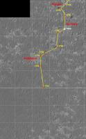
A quick map update for sol 1795.
And the layer(s) for Google Mars:  Route_Map_Sol1795.kml ( 9.18K )
Number of downloads: 996
Route_Map_Sol1795.kml ( 9.18K )
Number of downloads: 996 |
|
|
|
|
|
|
Feb 11 2009, 08:13 AM
Post
#2450
|
|
|
Special Cookie Group: Members Posts: 2168 Joined: 6-April 05 From: Sintra | Portugal Member No.: 228 |
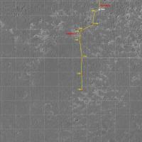
Tesheiner, from your map covering the whole distance between Victoria and Endeavour is it possible to find posted here the first section? The rectangle on the top left? Eagerly wanting to start mapping the second leg of the journey...
Thanks! -------------------- "Ride, boldly ride," The shade replied, "If you seek for Eldorado!"
Edgar Alan Poe |
|
|
|
|
Feb 11 2009, 10:00 AM
Post
#2451
|
|
|
Senior Member Group: Moderator Posts: 4279 Joined: 19-April 05 From: .br at .es Member No.: 253 |
Here's a link (http://www.unmannedspaceflight.com/index.p...st&p=127283, thanks James!) to a Tim Parker's post with a picture covering the whole route. I did a similar one on my own using CTX and HiRISE images which is the overview picture seen on the top left corner of the route map but I don't have it at full resolution, only at 25m/pix so it's maybe too small for your purposes. The original CTX image covering both VC and Endeavour is P01_001414_1780 but you'll have to rotate and re-scale it to match with the route map. PM me for more details.
|
|
|
|
|
Feb 11 2009, 11:06 AM
Post
#2452
|
|
|
Special Cookie Group: Members Posts: 2168 Joined: 6-April 05 From: Sintra | Portugal Member No.: 228 |
Thanks Tesheiner! That was just what I was looking for.
Have the new map ready, waiting for tosol's drive to update it, got the arrival to Porcupine set now for march 22 and the end of leg two for October 10, 2009...although I'm expecting Oppy to recover some of those 94 days of delay... 
-------------------- "Ride, boldly ride," The shade replied, "If you seek for Eldorado!"
Edgar Alan Poe |
|
|
|
|
Feb 12 2009, 09:26 PM
Post
#2453
|
|
|
Senior Member Group: Moderator Posts: 4279 Joined: 19-April 05 From: .br at .es Member No.: 253 |
|
|
|
|
|
Feb 13 2009, 06:04 AM
Post
#2454
|
|
|
Member Group: Members Posts: 235 Joined: 2-August 05 Member No.: 451 |
Can someone please remind me what the scale of the grid on this map is?
Thanks in advance. |
|
|
|
|
Feb 13 2009, 07:00 AM
Post
#2455
|
|
|
Senior Member Group: Moderator Posts: 4279 Joined: 19-April 05 From: .br at .es Member No.: 253 |
100m.
|
|
|
|
|
Feb 13 2009, 03:56 PM
Post
#2456
|
|
 Senior Member Group: Admin Posts: 4763 Joined: 15-March 05 From: Glendale, AZ Member No.: 197 |
Wow, we're really moving now.
-------------------- If Occam had heard my theory, things would be very different now.
|
|
|
|
| Guest_Enceladus75_* |
Feb 14 2009, 07:45 PM
Post
#2457
|
|
Guests |
Fantastic progress is being made by Oppy at the moment. Well done to RoverDriver and his colleagues!
Happy days...and I see Spirit is thought to have had a little "cleaning event" over at Gustav. 
|
|
|
|
|
Feb 14 2009, 11:19 PM
Post
#2458
|
|
 Member Group: Members Posts: 754 Joined: 9-February 07 Member No.: 1700 |
Oppy's gotta be setting a 1 week distance record! Keep on truckin'!
|
|
|
|
|
Feb 15 2009, 09:27 PM
Post
#2459
|
|
|
Senior Member Group: Moderator Posts: 4279 Joined: 19-April 05 From: .br at .es Member No.: 253 |
Not so fast. Today's drive was the shortest since the occultation period making a net move of around 4m (11.5m backwards followed by 16m forward slightly to the left of the previous path).
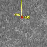 Route_Map_Sol1800n.kml ( 12K )
Number of downloads: 572
Route_Map_Sol1800n.kml ( 12K )
Number of downloads: 572 |
|
|
|
|
Feb 15 2009, 10:58 PM
Post
#2460
|
|||
 Senior Member Group: Moderator Posts: 2262 Joined: 9-February 04 From: Melbourne - Oz Member No.: 16 |
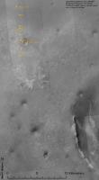
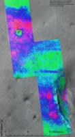
I thought it might help visualise our progress and speed towards Endeavour by plotting Opportunities position every 100 sols on a large map.
Now we're at sol 1800 here is the first one.
and with the ripple map overlay
James -------------------- |
||
|
|
|
||
|

|
Lo-Fi Version | Time is now: 27th May 2024 - 12:45 AM |
|
RULES AND GUIDELINES Please read the Forum Rules and Guidelines before posting. IMAGE COPYRIGHT |
OPINIONS AND MODERATION Opinions expressed on UnmannedSpaceflight.com are those of the individual posters and do not necessarily reflect the opinions of UnmannedSpaceflight.com or The Planetary Society. The all-volunteer UnmannedSpaceflight.com moderation team is wholly independent of The Planetary Society. The Planetary Society has no influence over decisions made by the UnmannedSpaceflight.com moderators. |
SUPPORT THE FORUM Unmannedspaceflight.com is funded by the Planetary Society. Please consider supporting our work and many other projects by donating to the Society or becoming a member. |
|