Storms from Orbit |

  |
Storms from Orbit |
 Sep 7 2008, 03:37 AM Sep 7 2008, 03:37 AM
Post
#1
|
||
 Senior Member  Group: Moderator Posts: 2785 Joined: 10-November 06 From: Pasadena, CA Member No.: 1345 |
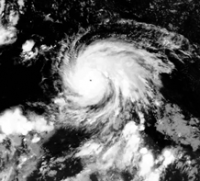
This is a project I've been working on for a while....it is an aligned sequence of images of Hurricane Dean in the Atlantic/Caribbean basin from 0000 UTC August 18, 2007 to 0900 UTC August 21, 2007. During this time, Hurricane Dean was a strong Category 4/5 storm.
(Click to view the animated GIF) The images are aligned such that the outer rain bands have minimal displacement (semi-rotating coordinate frame). The black dot in the middle of the image is the eye of the hurricane. Image source: EUMETSTAT NERC Satellite Receiving Station, Dundee University, Scotland; http://www.sat.dundee.ac.uk/ -Mike [EDIT: These were taken using IR (Channel 4) from the GOES12 satellite. The images have been contrast-enhanced to bring out detail in the cloud structure.] -------------------- Some higher resolution images available at my photostream: http://www.flickr.com/photos/31678681@N07/
|
|
 |
 
|
|
|
Sep 8 2008, 04:25 AM
Post
#2
|
||
|
Senior Member Group: Moderator Posts: 2785 Joined: 10-November 06 From: Pasadena, CA Member No.: 1345 |
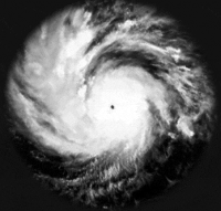
Spin-O-Vision of the core of Hurricane Dean:
(Click to launch GIF) Same image and source info as above, this time using a rotating coordinate frame (ca. 45 degrees counterclockwise/3 h, then adjusted to alignment) to freeze out the motion of the central core of the hurricane. From this (rotating) viewpoint, the outer rain bands can be seen to precess outwards clockwise. Some tweaking of contrast levels to bring out detail in the rain bands. (Cropping also done to prevent seasickness.) -Mike -------------------- Some higher resolution images available at my photostream: http://www.flickr.com/photos/31678681@N07/
|
|
|
|
|
|
|
Sep 14 2008, 07:47 PM
Post
#3
|
||
|
Senior Member Group: Moderator Posts: 2785 Joined: 10-November 06 From: Pasadena, CA Member No.: 1345 |
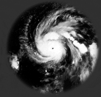
Spin-O-Vision of the outer fringes of Hurricane Dean:
(click to launch GIF) Rotating coordinate frame (5 degrees counterclockwise/3 h) to freeze out the motion of outer rain bands of the hurricane. The inner core spins much faster (45 degrees/3 h) and can be seen to provide impulsing shocks that create waves propagating outwards in the hurricanes outer edges. Some tweaking of contrast levels to bring out detail in the rain bands. Image source: EUMETSTAT NERC Satellite Receiving Station, Dundee University, Scotland; http://www.sat.dundee.ac.uk/ -Mike -------------------- Some higher resolution images available at my photostream: http://www.flickr.com/photos/31678681@N07/
|
|
|
|
|
|
|
Sep 14 2008, 07:53 PM
Post
#4
|
||
|
Senior Member Group: Moderator Posts: 2785 Joined: 10-November 06 From: Pasadena, CA Member No.: 1345 |
Animated zoom of the lower left section of the sequence above:
(click to launch GIF) With a 5 degree/3 h counterclockwise rotating coordinate frame to lock the outer band motion, the rhythmic wavelike nature (almost standing waves) of the outer rain band pulsations can be seen. -Mike -------------------- Some higher resolution images available at my photostream: http://www.flickr.com/photos/31678681@N07/
|
|
|
|
|
|
|
Sep 14 2008, 07:58 PM
Post
#5
|
||
|
Senior Member Group: Moderator Posts: 2785 Joined: 10-November 06 From: Pasadena, CA Member No.: 1345 |
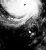
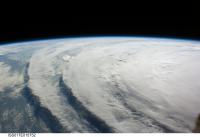
A stunning image from the ISS taken of Hurricane Ike approaching the Texas coast:
Image credit: NASA (Other images of Hurriane Ike from the ISS are available here) The wave-like nature compares to the Hurricane Dean sequence above. -Mike -------------------- Some higher resolution images available at my photostream: http://www.flickr.com/photos/31678681@N07/
|
|
|
|
|
|
|
Sep 7 2009, 07:07 PM
Post
#6
|
||
|
Senior Member Group: Moderator Posts: 2785 Joined: 10-November 06 From: Pasadena, CA Member No.: 1345 |
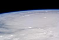
Aquavision image of Tropical Storm Erika in her final gasps:
Outflow band of whitish-blue cirrus can be seen. Combination of IR2, IR4, and WV band images gaken by GOES-E on September 2, 2009 at 1800 UTC. For scale, the Great Lakes can be seen at upper left of the image. Raw image source : NEODAAS/EUMETSAT/DSRS. -------------------- Some higher resolution images available at my photostream: http://www.flickr.com/photos/31678681@N07/
|
|
|
|
|
|
|
Oct 21 2009, 01:11 PM
Post
#7
|
|
|
Senior Member Group: Moderator Posts: 2785 Joined: 10-November 06 From: Pasadena, CA Member No.: 1345 |
Here is a time-lapse 4 minute video prepared by NOAA using orbital IR imagery for the entire 2008 North Atlantic hurricane season.
http://www.nnvl.noaa.gov/MediaDetail.php?M...p;MediaTypeID=2 (It is mesmerizing to watch, almost like the flames in a fire. The diurnal build up of thunderstorms creates a rhythmic pulsing pattern. Neat to see how a strong cold front sweeping across North America shuts down the diurnal effect.) -------------------- Some higher resolution images available at my photostream: http://www.flickr.com/photos/31678681@N07/
|
|
|
|
|
Oct 24 2009, 05:01 PM
Post
#8
|
||||
|
Member Group: Members Posts: 115 Joined: 8-January 05 From: Austin | Texas Member No.: 138 |
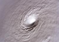
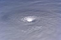
Just stumbled on this old thread -- here are some nice images of Hurricane Wilma from the ISS. Wilma was briefly the strongest hurricane every recorded -- the eye is just amazing.
--ups
Attached thumbnail(s)
|
|||
|
|
|
|||
|
Oct 25 2009, 03:38 PM
Post
#9
|
|
|
Member Group: Members Posts: 115 Joined: 8-January 05 From: Austin | Texas Member No.: 138 |
QUOTE (Juramike @ Oct 21 2009, 01:11 PM)  Here is a time-lapse 4 minute video prepared by NOAA using orbital IR imagery for the entire 2008 North Atlantic hurricane season. That's awesome -- thanks for posting. |
|
|
|
|
Oct 23 2010, 03:26 AM
Post
#10
|
|
|
Newbie Group: Members Posts: 2 Joined: 21-October 10 Member No.: 5499 |
The pictures are cool! Storms are stunning to look when viewed from distant, but destructive.
-------------------- Save Energy|Generate Solar Power For Homes with Homemade Solar Panels
|
|
|
|
|
Nov 8 2013, 05:55 PM
Post
#11
|
|
|
Senior Member Group: Members Posts: 1591 Joined: 14-October 05 From: Vermont Member No.: 530 |
Beautiful [composite?] image from EUMETSAT of Typhoon Haiyan:
http://www.flickr.com/photos/eumetsat/10726056545/ |
|
|
|
|

|
Lo-Fi Version | Time is now: 23rd September 2024 - 08:50 AM |
|
RULES AND GUIDELINES Please read the Forum Rules and Guidelines before posting. IMAGE COPYRIGHT |
OPINIONS AND MODERATION Opinions expressed on UnmannedSpaceflight.com are those of the individual posters and do not necessarily reflect the opinions of UnmannedSpaceflight.com or The Planetary Society. The all-volunteer UnmannedSpaceflight.com moderation team is wholly independent of The Planetary Society. The Planetary Society has no influence over decisions made by the UnmannedSpaceflight.com moderators. |
SUPPORT THE FORUM Unmannedspaceflight.com is funded by the Planetary Society. Please consider supporting our work and many other projects by donating to the Society or becoming a member. |
|