Titan's topography, strange.... |

  |
Titan's topography, strange.... |
 Sep 30 2009, 11:34 PM Sep 30 2009, 11:34 PM
Post
#61
|
||
|
Member  Group: Members Posts: 701 Joined: 1-April 08 From: Minnesota ! Member No.: 4081 |
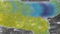
Here's a modified SARTopo map for Adiri and the T8 swath. The relative elevation of Adiri seems apparent. The eastern end has more elevated ridges to the south than the northern end of the swath and this seems evident. The Huygens landing site is in the southern swath portion.
|
|
 |
 
|
|
|
Sep 30 2009, 11:41 PM
Post
#62
|
||
|
Member Group: Members Posts: 701 Joined: 1-April 08 From: Minnesota ! Member No.: 4081 |
Here's a modified SARTopo map of the Huygens landing site. The last 2 frames embed a copy of Mike's 'vortex distorted' Karkoschka mosaic (PIA08114) highlighting the location.
|
|
|
|
|
|
|
Oct 4 2009, 05:17 PM
Post
#63
|
|
|
Member Group: Members Posts: 701 Joined: 1-April 08 From: Minnesota ! Member No.: 4081 |
QUOTE (titanicrivers @ Sep 30 2009, 06:41 PM)  Here's a modified SARTopo map of the Huygens landing site. The last 2 frames embed a copy of Mike's 'vortex distorted' Karkoschka mosaic (PIA08114) highlighting the location. Its interesting how the 'spooky dude' and major fluvial erosion features point in the direction of the lowest portion of the SARTopo (dark blue) swath as one might anticipate. |
|
|
|
|
Oct 4 2009, 06:00 PM
Post
#64
|
|
 Senior Member Group: Moderator Posts: 2785 Joined: 10-November 06 From: Pasadena, CA Member No.: 1345 |
The "spooky dude" feature still puzzles me. The tapered end points downhill. But the large oval depressions seem to be uphill from the tapered point. This is kinda opposite of what one would expect (I think).
-------------------- Some higher resolution images available at my photostream: http://www.flickr.com/photos/31678681@N07/
|
|
|
|
|
Oct 4 2009, 07:15 PM
Post
#65
|
|
|
Senior Member Group: Members Posts: 3516 Joined: 4-November 05 From: North Wales Member No.: 542 |
Mike, I noticed that you had implied this in one ot two other posts a while back. I've always taken on trust the eastward flow direction inferred in published papers on the landing site, but I have pondered whether I should be sharing your doubts.
For me it is the quasi-elliptical dark lobes that most graphically suggest a formation process for the spooky dude features. I picture each lobe as having been formed by a single huge 'river' of liquid pushing a moraine-like front of debris before it. Where it eventually loses momentum, or most of the liquid has drained into the ground, the debris front is deposited in place acting as a dam. Behind the dam there is still some liquid, and this being somewhat elevated with respect to the outside, some of it trickles through the dam forming small channels draining from inside the ellipse outward. I think this fairly describes what was seen in the few hundred metres around the landing site. What about the pointy ends? Well I've sort of half persuaded myself that if lobe-forming events happen repeatedly over time the loose material will be reworked into different patterns and earlier lobes may be truncated abruptly. Perhaps the points can be explained as bits and pieces of truncated lobes? I agree that this is shaky and I have often thought about staging an experiment to try to reproduce the shapes. I am hopeful that the VIMS landing site paper when it appears (soon?) will shed new light on what materials are actually involved in making these features, and how they might behave when mobile. |
|
|
|
|
Oct 4 2009, 07:58 PM
Post
#66
|
||
|
Member Group: Members Posts: 701 Joined: 1-April 08 From: Minnesota ! Member No.: 4081 |
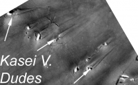
I would also wonder if catastrophic flow was running up against buried, more resilant and perhaps oval shaped calderas in which case one might get the spooky dude shape similar to the 'dudes' pictured below from the Kasei Valles on Mars. On Mars the resilant structures are crater rims. In many examples the upstream rim seems to erode first producing an open half-circle and the stream-lined point looking a bit like Titan's Dudes.
|
|
|
|
|
|
|
Oct 4 2009, 08:31 PM
Post
#67
|
|
|
Senior Member Group: Members Posts: 3516 Joined: 4-November 05 From: North Wales Member No.: 542 |
Against that suggestion I would note that these ovals really are very elongated and seem to be nicely aligned with the flow direction. There are craters and other raised features with leeward tails on Titan, but those do not resemble the spooky dude formation at all. Having said that, the possibility that resistant bedrock contributes part of the morphology, perhaps an important functional part, is also recognised in the literature and I wouldn't dismiss it entirely. My inclination for the moment, though, is to see the whole thing - dark playa material and bright pebbly moraines - as a drift deposit.
|
|
|
|
|
Oct 5 2009, 12:14 AM
Post
#68
|
|
|
Senior Member Group: Moderator Posts: 2785 Joined: 10-November 06 From: Pasadena, CA Member No.: 1345 |
Elevation shows the spooky dude formation is elevated a few hundred meters above the dark deposit.
If it was deposited by catastrophic liquid/mudflow, the stuff couldn't pile up higher than the liquid surface (*I think*). So if the whole shebang was deposited by an E-running liquid flow, it would imply a really, really big catastrophic flow. (Huygens Island is about the same elevation, what would constrain it through this channel at that elevation?) (Glacial moraine deposit is still possible - with the lobes being kettle holes). I think a possible scenario is that the formation was original bedrock, with cavities in the mass. Then a large catastrophic flow came from the E (going W, upgradient) and caused the tapering point towards the E. (An impact driven tsunami's could easily get that high with Titan's low gravity.) As the wave hit, it shaped the formation, and removed much of the loosely consolidated stuff covering the oval cavities on the backside of the formation. (The cavities were that shape pre-tsunami). But I still have just no clue... -------------------- Some higher resolution images available at my photostream: http://www.flickr.com/photos/31678681@N07/
|
|
|
|
|
Oct 5 2009, 01:49 AM
Post
#69
|
|
|
Member Group: Members Posts: 701 Joined: 1-April 08 From: Minnesota ! Member No.: 4081 |
QUOTE (Juramike @ Oct 4 2009, 07:14 PM) Elevation shows the spooky dude formation is elevated a few hundred meters above the dark deposit ... I think a possible scenario is that the formation was original bedrock, with cavities in the mass ... Hmm with that scenario and the current topography favoring a west to east direction, the occassionally fierce flows would extract the sediments and looser material from the cavities once the upstream wall of the formation was eroded and breached. Flow downhill would erode and sharpen the point and one shouldn't need catastrophic flows uphill in that case. |
|
|
|
|
Oct 5 2009, 06:12 AM
Post
#70
|
|
|
Senior Member Group: Members Posts: 3516 Joined: 4-November 05 From: North Wales Member No.: 542 |
QUOTE (Juramike @ Oct 5 2009, 01:14 AM) Elevation shows the spooky dude formation is elevated a few hundred meters above the dark deposit. If it was deposited by catastrophic liquid/mudflow, the stuff couldn't pile up higher than the liquid surface (*I think*). I think most of it is lower than that - more like tens of metres. As far as I know we don't have elevations for the features nearest the probe, but if they were hundreds of metres high we'd see that in the surface view. Also the banks could pile up higher than the liquid if some of the bank materials were buoyant, something that I have long suspected for a variety of reasons. But I have to admit that, like you, I just don't know. |
|
|
|
|
Oct 6 2009, 08:20 PM
Post
#71
|
||
|
Member Group: Members Posts: 701 Joined: 1-April 08 From: Minnesota ! Member No.: 4081 |
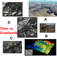
QUOTE (ngunn @ Oct 4 2009, 03:31 PM) Against that suggestion I would note that these ovals really are very elongated and seem to be nicely aligned with the flow direction ... I must confess the more I study the Huygen's channel the more similarities I find to some Earth catastrophic stream carved channel lands but at a smaller scale. Using the Channeled Scablands of the USA state of Washington for comparison one can find A) tapered streamlined elevations pointing downstream with alcoves and basins upstream. B oval scour basins at different elevations C) small channels cut through eroded ridges and D) other streamlined hills and erosional deposits pointing downstream at slightly different angles. If the spooky dudes are rock-hard water ice constructs wouldn't they be expected to be relatively resistant to moderate methane currents that would scour and remove looser non-ice deposits and small ice pebbles like the scabland floods removed loess and softer sedimentary rock while underlying bedrock was partially resistant?
|
|
|
|
|
|
|
Oct 6 2009, 09:03 PM
Post
#72
|
|
|
Senior Member Group: Members Posts: 3516 Joined: 4-November 05 From: North Wales Member No.: 542 |
Interesting comparisons there for sure. I'd like to take the digital terrain model at the bottom right there as a starting point for comments, first of all on the elevations question. That model and another like it form the basis of the statement by Soderblom et al that the bright features within the dark plains are around 100m (not hundreds of metres) high. That particular example shows a feature I have been calling 'the enclosure' some few kilometres southwest of the landing site. An interesting fact about the enclosure is that its interior is higher than the plains around it. Also, in general plan it does not resemble at all what we might call the classical spooky dude shapes with upstream ovals and downstream points. For both of these reasons I think it is actually something intrinsically different. (Your terrestrial analog for that feature is maybe less convincing that your others, which wouldn't be surprising if it is not in fact a flow feature.) The other 3D model shows mainly part of the 'Huygens island' with only a small part of the dark plain. The beach-like features there are actually contiguous with the island and may indeed be structurally part of it. Therefore they too, in my view, are ruled out of the spooky dude club. This means that for the features under discussion we have in fact no elevation data. The dark oval closest to the landing site is about 500 meters wide. It's bright boundary is only tens of metres wide and cannot be more that a few metres high in most places. The wider parts of the 'spooky dude' nearer the pointy end may be a bit higher, or they may not.
I agree with your statement that nothing in the immediate vicinity of the probe seems likely to be bedrock. The VIMS observation should contain pixels entirely filled by spooky dude bright stuff. I expect them to be spectrally distinct from the highlands bright stuff of the Huygens island. EDIT - the 'enclosure' shows up quite clearly on SAR - I think it was one of the features used by Mike and yourself for the most recent attempts at precise registration of the DISR with SAR - whereas the dudes are barely if at all visible, consistent with relatively low relief. |
|
|
|
|
Oct 7 2009, 12:34 AM
Post
#73
|
|
|
Senior Member Group: Moderator Posts: 2785 Joined: 10-November 06 From: Pasadena, CA Member No.: 1345 |
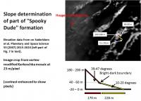
This oval feature shown above is part of the "Spooky Dude" formation. It is the 3rd or fourth oval-thingy over from where the Huygens probe landed.
The center of this feature is 3 km (almost exactly) to the ESE from where the probe touched down. I used the final version of Soderblom's paper (Soderblom et al. Planetary and Space Sci 55 (2007) 2015-2024) and imported the gridded DEM and scale into Photoshop to make absolutely sure of the scale match. The DEM I used is the furthest left figure in Figure 7 of the text. The tippy-top of the ridge is at 180-200 m elevation. The lowest point of the oval-thingy (center of the oval) is at -20-0 m elevation. The difference is between 220-180 m from the bottom of the oval to the top of the (pink) ridge. The green beach in this structure is at 20-40 m elevation. This is about the level of the bright-dark margin. From the top of the (pink) ridge to the (green) beach of the oval, it is an elevation differential of 180-140 m. This is over a horizontal distance of (7.21 pixels x 23 m/pixel) 170 m from the top of the ridge to the beach. The slope angle is between 47 and 39 degrees. (Very steep - this argues against the bright stuff being unconsolidated material). From the beach down to the center of the oval, it is a differential of 80 - 40 m over a horizontal distance of (9.9 pixel x 23 m/pixel) 228 m. Thus the dark stuff is at an angle between 20 and 10 degrees. (The terrain break supports an argument that the dark stuff was deposited or reworked by fluid or that it is unconsolidated stuff.) -Mike -------------------- Some higher resolution images available at my photostream: http://www.flickr.com/photos/31678681@N07/
|
|
|
|
|
Oct 7 2009, 01:11 AM
Post
#74
|
||
|
Senior Member Group: Moderator Posts: 2785 Joined: 10-November 06 From: Pasadena, CA Member No.: 1345 |
Graphic showing elevation trace (based only on the 3 points mentioned above):
-------------------- Some higher resolution images available at my photostream: http://www.flickr.com/photos/31678681@N07/
|
|
|
|
|
|
|
Oct 7 2009, 07:28 AM
Post
#75
|
|
|
Senior Member Group: Members Posts: 3516 Joined: 4-November 05 From: North Wales Member No.: 542 |
Right! Got my position wrong, but the arguments about the morphology being different from the features closer to the probe still remain - no lobes open in the upstream direction or downstream points. Does that feature show up on the radar? Need to look at that again. In this directon the Huygens DISR was looking into the light so genuine bits of highland terrain there would appear different to the Huygens island (which also has internal hollows with outward drainage to the plains like this feature). Roll on that VIMS paper.
Attached File(s)
|
|
|
|
|

|
Lo-Fi Version | Time is now: 8th June 2024 - 04:48 PM |
|
RULES AND GUIDELINES Please read the Forum Rules and Guidelines before posting. IMAGE COPYRIGHT |
OPINIONS AND MODERATION Opinions expressed on UnmannedSpaceflight.com are those of the individual posters and do not necessarily reflect the opinions of UnmannedSpaceflight.com or The Planetary Society. The all-volunteer UnmannedSpaceflight.com moderation team is wholly independent of The Planetary Society. The Planetary Society has no influence over decisions made by the UnmannedSpaceflight.com moderators. |
SUPPORT THE FORUM Unmannedspaceflight.com is funded by the Planetary Society. Please consider supporting our work and many other projects by donating to the Society or becoming a member. |
|