High-Res DEMs from single HiRISE images, First results of new "Shape from Shading" algorithm |

  |
High-Res DEMs from single HiRISE images, First results of new "Shape from Shading" algorithm |
 Jan 16 2010, 10:49 PM Jan 16 2010, 10:49 PM
Post
#16
|
|
|
Senior Member  Group: Members Posts: 3516 Joined: 4-November 05 From: North Wales Member No.: 542 |
Me too. I always prefer to see landscapes without the 'victorian-painter-in-the-highlands' effect. Very nice work tho.
|
 |
 
|
|
Jan 16 2010, 11:07 PM
Post
#17
|
|
 IMG to PNG GOD Group: Moderator Posts: 2254 Joined: 19-February 04 From: Near fire and ice Member No.: 38 |
QUOTE (Nirgal @ Jan 16 2010, 10:27 PM)  There is no texture mapping or smoothing involved: every pixel is real 3D - The DEM itself is detailed down to the single pixel level. I suspected this from the first message but wanted to be sure. This makes this DEM even more amazing. QUOTE (Nirgal @ Jan 16 2010, 10:27 PM) That's the really interesting thing with this new techinque: The absence of the strong smoothing process that gives many conventional DEM-images that somewhat "washed", unnaturally soft appearance.  (however: while it works perfectly for the higher frequency bands, there can be distortions in the lower frequency components ... so the DEMs in their current form could probably not be used for exact inference about variations of absolute terrain heights over larger scales (that's where MOLA and conventional stereo based techniques have advantages: so it seems natural to combine the techniques) ... It would be really interesting to see DEMs for bodies like Europa and Enceladus. Also I have a global DEM of Rhea so a comparison to my results there would be interesting. As you mentioned a DEM from your software would be far more detailed than mine but low frequency variations would be less accurate (combining results from these two approaches might be interesting for big impact basins like Tirawa). |
|
|
|
|
Jan 16 2010, 11:16 PM
Post
#18
|
|
|
Member Group: Members Posts: 713 Joined: 30-March 05 Member No.: 223 |
QUOTE (Bjorn Jonsson @ Jan 17 2010, 12:07 AM) I suspected this from the first message but wanted to be sure. This makes this DEM even more amazing. It would be really interesting to see DEMs for bodies like Europa and Enceladus. Also I have a global DEM of Rhea so a comparison to my results there would be interesting. As you mentioned a DEM from your software would be far more detailed than mine but low frequency variations would be less accurate (combining results from these two approaches might be interesting for big impact basins like Tirawa). Thanks Björn, i too am interested in combing the various DEM approaches but at the moment, unfortunately lacking the time (still working on the improvement to the single-image SFS method) here is another image (a close up of gully wall) that illustrates the high detail preservation (it's not even rendered at full resolution) (click for larger version)  And for Stu and and ngunn: no vertical (i.e. profile) exaggeration this time :-) |
|
|
|
|
Jan 16 2010, 11:26 PM
Post
#19
|
|
|
Merciless Robot Group: Admin Posts: 8785 Joined: 8-December 05 From: Los Angeles Member No.: 602 |
 ...how sedimentary can you get? ...how sedimentary can you get?
-------------------- A few will take this knowledge and use this power of a dream realized as a force for change, an impetus for further discovery to make less ancient dreams real.
|
|
|
|
|
Jan 17 2010, 10:18 AM
Post
#20
|
|
|
Senior Member Group: Members Posts: 3516 Joined: 4-November 05 From: North Wales Member No.: 542 |
QUOTE (Nirgal @ Jan 16 2010, 11:16 PM) no vertical exaggeration Excellent! Now I can make an informed choice of footwear. Please excuse a very basic question. If these are made from single images how do you prevent albedo differences from masquerading as relief? |
|
|
|
|
Jan 17 2010, 12:25 PM
Post
#21
|
|
|
Member Group: Members Posts: 713 Joined: 30-March 05 Member No.: 223 |
QUOTE (ngunn @ Jan 17 2010, 11:18 AM) Excellent! Now I can make an informed choice of footwear. Please excuse a very basic question. If these are made from single images how do you prevent albedo differences from masquerading as relief? of course there is no general solution to deal with varying albedo in "shape-from-single-image", because, as you pointed out, any difference in luminance will be interpreted as difference in local surface orientation. (The same problem also occurs for cast shadows that will be interpreted just as flat areas) However, experience shows that the underlying assumption of constant albedo works surprisingly well for large parts of the martian surface where there is very little variance in surface color and albedo. Furthermore, the general idea with the SFS approach is to incorporate additional depth information from stereo or altimeter based measurements, so those techniques nicely complement each other |
|
|
|
|
Jan 17 2010, 03:14 PM
Post
#22
|
|
|
Founder Group: Chairman Posts: 14434 Joined: 8-February 04 Member No.: 1 |
If you want a good test - try the Pathfinder observations
|
|
|
|
|
Jan 17 2010, 06:09 PM
Post
#23
|
|||
 Senior Member Group: Admin Posts: 4763 Joined: 15-March 05 From: Glendale, AZ Member No.: 197 |
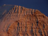
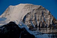
And for an Earthly analog here is the Emperor Face of Mt. Robson, the highest peak in the Canadian Rockies. (If it's anything similar Nigel I wouldn't just worry about what you are wearing on your feet but which implements you are carrying in your hands as well.)
Attached thumbnail(s)
-------------------- If Occam had heard my theory, things would be very different now.
|
||
|
|
|
||
|
Jan 17 2010, 07:17 PM
Post
#24
|
|
 Member Group: Members Posts: 646 Joined: 23-December 05 From: Forest of Dean Member No.: 617 |
...what everyone else has said!
I know very little of the field, but isn't this somewhat ground-breaking, revolutionary work that will have significant applications, like, all over the place? Including earth observations? (As a somewhat random example, there's an appeal out for high-res DEMs of Haiti : http://www.boingboing.net/2010/01/15/haiti...#comment-688501 ) Forgive a lay-person's question: would it be possible to drape a texture map or surface image over the DEM, without it looking really ugly and pixellated in places? QUOTE (Nirgal @ Jan 16 2010, 10:27 PM) P.S.: I also forgot to mention that in most images the vertical scale is exaggerated by a factor of about 1.5 to 2. Ah, that's just what I was wondering; those dunes looked a little steep. -------------------- --
Viva software libre! |
|
|
|
|
Jan 18 2010, 10:26 AM
Post
#25
|
|
|
Member Group: Members Posts: 713 Joined: 30-March 05 Member No.: 223 |
QUOTE (imipak @ Jan 17 2010, 08:17 PM) ...what everyone else has said! I know very little of the field, but isn't this somewhat ground-breaking, revolutionary work that will have significant applications, like, all over the place? Including earth observations? I would not use such big words like "revolutionary" (this would be waaay too much honor  ) ) The field of single-image "Shape-from-Shading" (SfS) has been a classical area of computer vision since the 1970s (in the planetary science community also known under the name photoclinometry) and it has also been widely applied already for planetary data sets. See for example the seminal work done by Randolph Kirk of USGS in the field. Among other notable applications, SfS/photoclinometric methods based on MGS/MOC imagery were involved with the MER landing site selections. For a general survey on the field, see for example this paper The current new method that I'm experimenting with at the moment, does seem to have the potential to improve on existing approaches in particular with respect to the better preserving of high frequency (i.e. detail) variations, whereas on the other hand it too suffers from some of the (fundamental) problems inherent to any single-image method, namely the constant-albedo, shadows, convex-concave-ambiguity, low-frequency distortions to name a few (thats were it could be complemented with the already mentiond combination with stereo- and altimeter-based methods ) However, at this time I'm at a very early stage of experimenting and it's way too early for a final conclusive judgment. I just wanted to share the first results, because I for myself was surprised that they came out rather promising. But there is still a lot of work to do before any definite conclusions can be drawn. Its more of an evolutionary than revolutionary process
|
|
|
|
|
Jan 18 2010, 01:15 PM
Post
#26
|
|||
|
Member Group: Members Posts: 713 Joined: 30-March 05 Member No.: 223 |
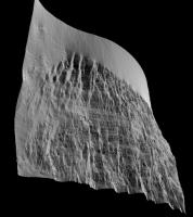
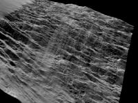
QUOTE (ElkGroveDan @ Jan 17 2010, 07:09 PM) And for an Earthly analog here is the Emperor Face of Mt. Robson, the highest peak in the Canadian Rockies. (If it's anything similar Nigel I wouldn't just worry about what you are wearing on your feet but which implements you are carrying in your hands as well.) just for fun (and comparison with the Mars DEMs): here is a quick try of the SFS method to the earthly Mt. Robson (unoptimized low-res, just from the noisy JPEG image as attached to ElkroveDan's post above) Here are some views of the resulting 3D DEM:
|
||
|
|
|
||
|
Jan 18 2010, 02:49 PM
Post
#27
|
|
 Senior Member Group: Members Posts: 1089 Joined: 19-February 05 From: Close to Meudon Observatory in France Member No.: 172 |
Bernhard, your work is "estupendo" ! "Stupéfiant" ! Brilliant ! ...I'm just lacking of words to express my enthusiasm about what you did.
BRAVO ! |
|
|
|
|
Jan 18 2010, 04:27 PM
Post
#28
|
|
|
Junior Member Group: Members Posts: 79 Joined: 11-September 09 Member No.: 4937 |
QUOTE (Nirgal @ Jan 18 2010, 02:26 AM) I would not use such big words like "revolutionary" (this would be waaay too much honor ) I just wanted to share the first results, because I for myself was surprised that they came out rather promising. But there is still a lot of work to do before any definite conclusions can be drawn.You are waaay too modest -- these are extraordinary. I never expected to hover off a martian crater wall in a helicopter. |
|
|
|
|
Jan 18 2010, 05:20 PM
Post
#29
|
|
|
Senior Member Group: Members Posts: 2922 Joined: 14-February 06 From: Very close to the Pyrénées Mountains (France) Member No.: 682 |
Bernhard, after Olivier's statement, knowing what he does himself, I only can add: "Salut l'Artiste".
-------------------- |
|
|
|
|
Jan 18 2010, 08:42 PM
Post
#30
|
|
|
Member Group: Members Posts: 808 Joined: 10-October 06 From: Maynard Mass USA Member No.: 1241 |
Bernhard,
What could your technique do with a fairly bland area, such as Meridiani? Would you be able to discern the small rise that fresh crater (conception) sits upon? Cheers -------------------- CLA CLL
|
|
|
|
|

|
Lo-Fi Version | Time is now: 22nd September 2024 - 07:11 AM |
|
RULES AND GUIDELINES Please read the Forum Rules and Guidelines before posting. IMAGE COPYRIGHT |
OPINIONS AND MODERATION Opinions expressed on UnmannedSpaceflight.com are those of the individual posters and do not necessarily reflect the opinions of UnmannedSpaceflight.com or The Planetary Society. The all-volunteer UnmannedSpaceflight.com moderation team is wholly independent of The Planetary Society. The Planetary Society has no influence over decisions made by the UnmannedSpaceflight.com moderators. |
SUPPORT THE FORUM Unmannedspaceflight.com is funded by the Planetary Society. Please consider supporting our work and many other projects by donating to the Society or becoming a member. |
|