Whole Earth images, Does any satellite provide regularly updated ones? |

  |
Whole Earth images, Does any satellite provide regularly updated ones? |
 Jan 20 2010, 12:29 PM Jan 20 2010, 12:29 PM
Post
#136
|
|
|
Solar System Cartographer  Group: Members Posts: 10226 Joined: 5-April 05 From: Canada Member No.: 227 |
Ted's right. LOIRP has done that image, but the linked version is not theirs.
Phil -------------------- ... because the Solar System ain't gonna map itself.
Also to be found posting similar content on https://mastodon.social/@PhilStooke Maps for download (free PDF: https://upload.wikimedia.org/wikipedia/comm...Cartography.pdf NOTE: everything created by me which I post on UMSF is considered to be in the public domain (NOT CC, public domain) |
 |
 
|
|
Jan 21 2010, 08:34 PM
Post
#137
|
|
 Member Group: Members Posts: 796 Joined: 27-February 08 From: Heart of Europe Member No.: 4057 |
One of the first attempts to image Earth from space, was possibly from Able-1 (Pioneer 2?) probe, but failed, because major part of Earth seen from spacecraft was in darkness.
-------------------- |
|
|
|
|
Jan 24 2010, 01:00 AM
Post
#138
|
|
 Junior Member Group: Members Posts: 21 Joined: 21-September 07 From: Seattle Member No.: 3912 |
QUOTE (tedstryk @ Jan 20 2010, 03:25 AM)  I don't think that is from LOIRP, but it is a nice image. Sorry, I should clarify. You can find the "LOIRP TIFF" linked at the bottom of the page. It apparently weighs 1.2 GB, so I didn't direct-link it. edit: Aha. You can preview it here. |
|
|
|
|
Jan 24 2010, 07:57 AM
Post
#139
|
|
 Senior Member Group: Members Posts: 2492 Joined: 15-January 05 From: center Italy Member No.: 150 |
So huge... did someone made a lighter med-res version?
-------------------- I always think before posting! - Marco -
|
|
|
|
|
Jan 25 2010, 04:44 PM
Post
#140
|
|
 Administrator Group: Admin Posts: 5172 Joined: 4-August 05 From: Pasadena, CA, USA, Earth Member No.: 454 |
I don't know if it's true for this one, but when I have downloaded LOIRP TIFFs in the past, I found they had two layers, one of which was empty, but both of which were saved without compression, needlessly doubling the file size. All they have to do is toss the extra layer and use LZW compression and it'd save a lot of people a lot of time (and them a lot of bandwidth).
-------------------- My website - My Patreon - @elakdawalla on Twitter - Please support unmannedspaceflight.com by donating here.
|
|
|
|
|
Jan 28 2010, 12:58 AM
Post
#141
|
||
 Senior Member Group: Moderator Posts: 2785 Joined: 10-November 06 From: Pasadena, CA Member No.: 1345 |
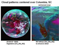
Image of Earth taken today at 1800Z (several hours ago). A zoom shows a weird pattern in the IR4 and Water Vapor channels that is roughly funkiest right over Columbia, South Carolina.
It is not evident in the Visible image and only faintly discernible from white background in the IR2 image. (So...colder high altitude contrails? Why not over the busier airports of Atlanta or Charlotte?) Any guesses?? -------------------- Some higher resolution images available at my photostream: http://www.flickr.com/photos/31678681@N07/
|
|
|
|
|
|
|
Jan 28 2010, 01:03 AM
Post
#142
|
|
|
Merciless Robot Group: Admin Posts: 8785 Joined: 8-December 05 From: Los Angeles Member No.: 602 |
Gotta be contrails. Answer is that those are high-alt corridors. Near the airports planes are ascending or descending, not cruising @ 30K+ ft., therefore much slower speeds & much shorter ground tracks.
-------------------- A few will take this knowledge and use this power of a dream realized as a force for change, an impetus for further discovery to make less ancient dreams real.
|
|
|
|
|
Jan 28 2010, 01:09 AM
Post
#143
|
|
|
Member Group: Members Posts: 166 Joined: 20-September 05 From: North Texas Member No.: 503 |
QUOTE (Juramike @ Jan 28 2010, 01:58 AM) Any guesses?? Not only do contrails not show up over the major airport hubs (where aircraft are indeed at lower levels) the contrails will only show up where there is sufficient moisture in the upper atmosphere for the contrails to persist long enough to be imaged from space. There was obviously more moisture available over SC at the time this photo was taken, than in areas farther south, where the contrails do not persist. David |
|
|
|
|
Jan 28 2010, 01:44 AM
Post
#144
|
|
|
Senior Member Group: Moderator Posts: 2785 Joined: 10-November 06 From: Pasadena, CA Member No.: 1345 |
Thanks!
I poked around other time points on the same day, and same time point on different days and didn't see the same phenomenon. Must've just hit the atmospheric conditions just right over the Carolinas. Color us lucky...'till the snowstorm hits this weekend. -------------------- Some higher resolution images available at my photostream: http://www.flickr.com/photos/31678681@N07/
|
|
|
|
|
May 25 2010, 10:47 AM
Post
#145
|
|
|
Senior Member Group: Moderator Posts: 2785 Joined: 10-November 06 From: Pasadena, CA Member No.: 1345 |
The Dundee Satellite Receiving Station home page (DSRS) (here) has just activated a very neat feature. They have a clickable calendar at the top of the screen, you can now easily click back and forth through the archive.
With a fast enough connection, this can almost be a stepwise animation. -------------------- Some higher resolution images available at my photostream: http://www.flickr.com/photos/31678681@N07/
|
|
|
|
|
May 28 2010, 02:42 PM
Post
#146
|
|
|
Senior Member Group: Moderator Posts: 2785 Joined: 10-November 06 From: Pasadena, CA Member No.: 1345 |
24 hour animated sequence of Earth images in Aquavision from May 27th 0600 UTC to May 28th 0300 UTC:
Available here: http://www.flickr.com/photos/31678681@N07/4646189185/ -------------------- Some higher resolution images available at my photostream: http://www.flickr.com/photos/31678681@N07/
|
|
|
|
|
Jun 24 2010, 10:19 PM
Post
#147
|
|
|
Senior Member Group: Members Posts: 1591 Joined: 14-October 05 From: Vermont Member No.: 530 |
Great new mosaic from LROC:
http://lroc.sese.asu.edu/news/index.php?/a...m-the-Moon.html |
|
|
|
|
Jun 25 2010, 06:49 PM
Post
#148
|
|
 Senior Member Group: Members Posts: 1669 Joined: 5-March 05 From: Boulder, CO Member No.: 184 |
Has anyone mentioned this link showing real-time Meteosat images?
http://oiswww.eumetsat.org/IPPS/html/MSG/IMAGERY/ -------------------- Steve [ my home page and planetary maps page ]
|
|
|
|
|
Aug 16 2010, 10:46 AM
Post
#149
|
|
 Senior Member Group: Members Posts: 3648 Joined: 1-October 05 From: Croatia Member No.: 523 |
This is neat - July 11 solar eclipse seen on the DishEARTH channel.
-------------------- |
|
|
|
|
Aug 29 2010, 02:08 PM
Post
#150
|
||
|
Senior Member Group: Moderator Posts: 2785 Joined: 10-November 06 From: Pasadena, CA Member No.: 1345 |
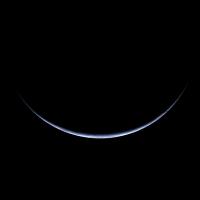
Digging around, I found some really neat high-phase angle shots of Earth taken by the SEVERI Meteosat near the December 21 solstice. This is taken at local midnight, so we are seeing the midnight sun over Antarctica.
At this high phase angle, the Near IR data isn't too bright and can be gently blended into a channel mix with the Vis R-G and Vis G-B to make a pretty RGB composite. There's a neat specular reflection off Antarctica ice or smooth embayed water.
Check out the REALLY high res image on my flickr site (processing details there, too.): http://www.flickr.com/photos/31678681@N07/4937955948/ -------------------- Some higher resolution images available at my photostream: http://www.flickr.com/photos/31678681@N07/
|
|
|
|
|
|
|

|
Lo-Fi Version | Time is now: 21st September 2024 - 07:11 AM |
|
RULES AND GUIDELINES Please read the Forum Rules and Guidelines before posting. IMAGE COPYRIGHT |
OPINIONS AND MODERATION Opinions expressed on UnmannedSpaceflight.com are those of the individual posters and do not necessarily reflect the opinions of UnmannedSpaceflight.com or The Planetary Society. The all-volunteer UnmannedSpaceflight.com moderation team is wholly independent of The Planetary Society. The Planetary Society has no influence over decisions made by the UnmannedSpaceflight.com moderators. |
SUPPORT THE FORUM Unmannedspaceflight.com is funded by the Planetary Society. Please consider supporting our work and many other projects by donating to the Society or becoming a member. |
|