High-Res DEMs from single HiRISE images, First results of new "Shape from Shading" algorithm |

  |
High-Res DEMs from single HiRISE images, First results of new "Shape from Shading" algorithm |
 Mar 1 2010, 10:57 PM Mar 1 2010, 10:57 PM
Post
#61
|
|
|
Senior Member  Group: Members Posts: 3516 Joined: 4-November 05 From: North Wales Member No.: 542 |
No I don't, unfortunately. Go to the 'Endeavour crater, and again we shall conquer the remoteness' thread post 105 and following and you will find all I have on this. Others here may be able to help more.
|
 |
 
|
|
Mar 2 2010, 06:52 AM
Post
#62
|
|
|
Senior Member Group: Moderator Posts: 4279 Joined: 19-April 05 From: .br at .es Member No.: 253 |
AFAIK, that's the non-map-projected version of PSP_010341_1775.
|
|
|
|
|
Mar 2 2010, 08:44 PM
Post
#63
|
|
|
Member Group: Members Posts: 713 Joined: 30-March 05 Member No.: 223 |
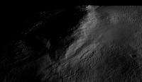
Upon a request posed over at the "Dust Avalanche" thread I did a small 3D DEM study of an area near Endeavour Crater based on a single image cropped from PSP_010341_1775.
 Click image to see the whole gallery. The first image shows the DEM rendered from above with the same lighting conditions as the original image so as to give an idea of the accuracy of the 3D reconstruction (note, however, that the accuracy decreases somewhat when the DEM is lit from other than the original lighting direction). The generated DEM consists of 8192x4096 = 32 million polygons with true 3D (means no texturing) post spacing at full HiRISE resolution (28.6 cm/pixel ). Here is my usual Disclaimer: the rendered DEMs are intended for visualization only. The absolute heights are not calibrated and there may be distortions due to albedo variations. |
|
|
|
|
Mar 2 2010, 09:03 PM
Post
#64
|
|
|
Senior Member Group: Members Posts: 3516 Joined: 4-November 05 From: North Wales Member No.: 542 |
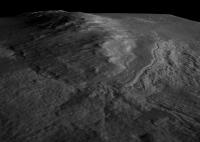
YES!! Now that is everything I'd hoped for and more. Enormous thanks Nirgal. Can you say if there is vertical exaggeration there, and if so how much? This does indeed look like a most worthy target for Opportunity.
(thanks Tesheiner also for undoing my thread tangle) |
|
|
|
|
Mar 2 2010, 09:06 PM
Post
#65
|
|
|
Senior Member Group: Moderator Posts: 4279 Joined: 19-April 05 From: .br at .es Member No.: 253 |
Incredible!
BTW, I think we'll have to save this picture, bookmark this thread / post, and revisit it in about one year to compare it with the "ground truth". |
|
|
|
|
Mar 2 2010, 09:33 PM
Post
#66
|
|
|
Member Group: Members Posts: 713 Joined: 30-March 05 Member No.: 223 |
QUOTE (ngunn @ Mar 2 2010, 10:03 PM)  Can you say if there is vertical exaggeration there, and if so how much? I can not give an exact answer to this one as I do not usually put much effort into calibration of abolute heights (for my visualization purposes it's sufficient that the rendered DEM looks approximately the same as the original 2D image when viewed and illuminated under the same conditions ) Then I do have a switch, called "Z_scale_factor" that I sometimes use to exaggerate (or attenuate) the heights artificially. in this case the factor was 1.3 so there is some exaggeration (just for better emphasis of terrain variation) but moderately so. |
|
|
|
|
Mar 3 2010, 11:15 AM
Post
#67
|
|||
 Member Group: Members Posts: 155 Joined: 8-February 04 From: Phoenix, AZ USA Member No.: 9 |
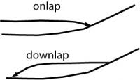
This area has fascinated me for a while and Nirgal's renders have crystallized some of my thoughts. Since I'm a sequence stratigrapher by trade and training (and some say religion...), I look at strata in terms of their geometry (shape and topology of the boundaries) and where and how they terminate. The method of tracking stratal terminations originally comes from interpreting seismic profiles (seismic stratigraphy) where one traces the continuity and termination of reflections. Through this, relative ages, directions of transport, subsidence patterns patterns and other cool things can be determined. Among other types, some of the most obvious stratal terminations include onlap, downlap, and truncation. These little schematic cross sections show the geometry of onlapping and downlapping strata:
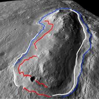
In the image from Nirgal below, I've highlighted several areas of stratal terminations in one of my (in)famous 5 minute speed interpretations:
red: onlap blue: downlap white: truncation by channels The slightly sinuous channel on the right side of the image does some really cool things, including exiting the terrace region at the top of the image through a v-notched canyon. It suggests the channel is a subsequent geomorphic feature that has incised into previously buried strata as the landscape has been regionally degraded (think Colorado Plateau, Canyonlands, Grand Canyon, etc.). The raised lip of the terrace on the right is also intriguing (due to channel incising?, differential erosion?, etc.) In general, the hill looks like it was a preexisting topographic feature that was onlapped by several periods of deposition, including the terrace unit which seems to have formed as an apron of downlapping strata that prograded away from the hill (like a shoreline). Subsequent regional landscape degradation has exposed various levels in the stratigraphy which allows us to examine the relative timing and geometry. The degradation has included a channel-incisement phase that has cut through most of the units and has been guided by the differential erodibility of the strata. Ground truthing these interpretations when Opportunity get here, especially examining the depositional nature of the units and the relative timing of deposition and erosion, is going to be very interesting! -------------------- Tim Demko
BioLink site |
||
|
|
|
||
|
Mar 3 2010, 12:57 PM
Post
#68
|
|
|
Senior Member Group: Members Posts: 3516 Joined: 4-November 05 From: North Wales Member No.: 542 |
QUOTE (tdemko @ Mar 3 2010, 11:15 AM) The raised lip of the terrace on the right is also intriguing Fascinating interpretation there, thanks for sharing. There is one note of caution I'd like to sound in relation to small details of these images - it may be wrong and if so I hope Nirgal will correct me. He himself pointed out that albedo differences could affect his results here. In particular the 'beach terrace' is lighter toned than most of the rest of the scene. I think this might account for its edge looking different on each side of the hill, depending on the original direction of illumination. Funnily enough this difference was the first thing my daughter remarked upon when I showed her the images. Is it real or not? I'm not sure. I have another question. What is the elevation of the 'beach terrace' and how does it compare with the lowest elevation on the perimeter of Endeavour? I think they're fairly close. |
|
|
|
|
Mar 3 2010, 02:32 PM
Post
#69
|
|
 Senior Member Group: Admin Posts: 4763 Joined: 15-March 05 From: Glendale, AZ Member No.: 197 |
QUOTE (tdemko @ Mar 3 2010, 03:15 AM) This area has fascinated me for a while Me too. I've been drooling over it. Thanks Tim for your nice clean interpretation and diagram. A lot of it fits my thinking, though I was scratching my head about that channel on the north end. -------------------- If Occam had heard my theory, things would be very different now.
|
|
|
|
|
Mar 3 2010, 02:33 PM
Post
#70
|
|
|
Member Group: Members Posts: 933 Joined: 4-September 06 From: Boston Member No.: 1102 |
A question for Tim and Nirgal: This is one of the hills on the western edge of Endeavour? If so, Tim's comment "In general, the hill looks like it was a preexisting topographic feature that was onlapped by several periods of deposition" refers to geologic changes much after formation of the crater? I assume the hill was created by the impact and was not there prior to the impact. Sorry for my confusion.
-------------------- |
|
|
|
|
Mar 3 2010, 02:58 PM
Post
#71
|
|
|
Senior Member Group: Members Posts: 3516 Joined: 4-November 05 From: North Wales Member No.: 542 |
Zoomable CTX of the area:
http://global-data.mars.asu.edu/ctx/img/P0...1780_XI_02S005W Looks like the next hill to the south has similar features at its northern end (Nirgal???  ) )
|
|
|
|
|
Mar 3 2010, 03:27 PM
Post
#72
|
|
|
Member Group: Members Posts: 713 Joined: 30-March 05 Member No.: 223 |
QUOTE (ngunn @ Mar 3 2010, 01:57 PM) Fascinating interpretation there, thanks for sharing. There is one note of caution I'd like to sound in relation to small details of these images - it may be wrong and if so I hope Nirgal will correct me. He himself pointed out that albedo differences could affect his results here. Correct. that's why I usually add my "for visualization purposes only" disclaimer  without knowledge of the true albedo variations, it's difficult to interpret the apparent height variations. QUOTE in relation to small details of these images. actually it's quite the opposite: the smaller the detail, the better the accuracy of the 3D reconstruction (look at how the small craters and mini dune ripples got reproduced) because albedo variations occur more at larger spatial scales. That's why the photoclinometric method can nicely complement the mult-image stereo-based methods that are less accurate at the very finest scale (you need features spanning areas of multiple pixels for the point matching algorithm) but are not so easily tricked by albedo variations. So as mentinoed before: the real potential of the method for scientific usage could only be exploited by combing it with stereo/altimeter based data. That being said: it is surprising how well the single-image reconstruction often works even in presence of albedo differences and cast shadows (see for example the dark dust steaks over the fine dune ripples in the image posted at the other thread) However, while often working pretty well, there is unfortunately no guarantee so (I have also encountered examples where the albedo problem messed up the 3D reconstruction completely ) I'm sure we will have an official stereo-based HiRISE DEM at 1m/pixel reslution of this area soon. Then I can try to combine the 1m/pixel stereo-DEM it with my 25cm/pixel photoclinometric DEM to possibly get the best out of both worlds ... But until then I reiterate my note of caution with respect to scientific/geologic interpretations based on the single-image DEMs that I want to be understood mainly as a means of visualization rtaher than a measurement tool ... However, it's totally ok and a pleasure for me to see that the visualizations help to spark new and crystalize previously existing ideas... But for such ideas to be finally proven, I think we will need the real ground truth data in the end. |
|
|
|
|
Mar 3 2010, 06:37 PM
Post
#73
|
||||
|
Member Group: Members Posts: 713 Joined: 30-March 05 Member No.: 223 |
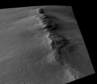
For comparison, here is (a crop of) the original, radiometrically calibrated HiRISE-image I used as input for the 3D reconstruction algorithm (all images at half resolution) A:
which yields the following DEM (greylevel = height) B:
Now, once I have the DEM I can re-render it under exactly the same illumination conditions (incidence angle, sub-solar azimut etc.) as the original image, which yields this view: C:
So comparing A and C gives an idea of the accuracy of the reconstruction process (as can be seen, the so called "photometric error" is almost zero). However, the low photometric error does not tell the whole story because it does not address the albedo variations which can not be resolved from a single image alone without additional information. The comparison shows, that the reconstruction can be quite exact, at least in the absence of albedo variations... (The increased contrast in C is due to the higher dynamic range of greylevels used by the 3D renderer compared to the somewhat hazy original image) |
|||
|
|
|
|||
|
Mar 3 2010, 07:11 PM
Post
#74
|
|
|
Member Group: Members Posts: 362 Joined: 13-April 06 From: Malta Member No.: 741 |
To me it looks like an' island' which eventually got surrounded by lava!Very much like the Columbia Hills in Gusev Crater.So the elevated unit(part of crater rim) should be an older geologic unit compared to the lower areas surrounding it.Any idea as to minerals identified in this unit??
|
|
|
|
|
Mar 4 2010, 08:06 AM
Post
#75
|
|||||
|
Member Group: Members Posts: 713 Joined: 30-March 05 Member No.: 223 |
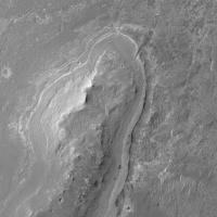
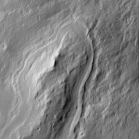
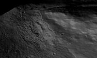
QUOTE (ngunn @ Mar 3 2010, 03:58 PM) Looks like the next hill to the south has similar features at its northern end (Nirgal??? )Yes indeed similar. here are some detail 3D views of the northern end of the next hill to the south. No vertical exaggeration this time. alternatively I rendered the DEMs with a simulated lower sun angle (i.e. later evening view) than the original in order to pronounce the terrain variations
Here is a "Fly-over-view" from the south (north is up) showing the whole "atoll-like" hill complex: [attachment=20917:enw4_a.jpg]
Attached thumbnail(s)
|
||||
|
|
|
||||
|

|
Lo-Fi Version | Time is now: 22nd September 2024 - 04:27 AM |
|
RULES AND GUIDELINES Please read the Forum Rules and Guidelines before posting. IMAGE COPYRIGHT |
OPINIONS AND MODERATION Opinions expressed on UnmannedSpaceflight.com are those of the individual posters and do not necessarily reflect the opinions of UnmannedSpaceflight.com or The Planetary Society. The all-volunteer UnmannedSpaceflight.com moderation team is wholly independent of The Planetary Society. The Planetary Society has no influence over decisions made by the UnmannedSpaceflight.com moderators. |
SUPPORT THE FORUM Unmannedspaceflight.com is funded by the Planetary Society. Please consider supporting our work and many other projects by donating to the Society or becoming a member. |
|