Titan's topography, strange.... |

  |
Titan's topography, strange.... |
 Oct 11 2009, 10:35 PM Oct 11 2009, 10:35 PM
Post
#76
|
||
|
Member  Group: Members Posts: 700 Joined: 1-April 08 From: Minnesota ! Member No.: 4081 |
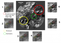
QUOTE (ngunn @ Oct 7 2009, 02:28 AM)  Right! Got my position wrong, but the arguments about the morphology being different from the features closer to the probe still remain - no lobes open in the upstream direction or downstream points. Does that feature show up on the radar? Need to look at that again. Taking stills from my animated post # 569 of the Huygens Landing thread I show in the graphic below the spooky dude arrowhead area, the oval basins area and the 'enclosure'. The central figure (the DISR modified Karkoschka image) shows the structures. Side panel #1 shows whats visible in the SAR alone and #2 through #6 overlays the DISR image in increasing amounts to help in identification. The dude arrowhead north edge and 2 hills (one bright one dark) appear, the oval basins are not too visible and dark portions of the enclosure show up. Given the complexity of what makes structures visible in SAR its hard to be definite about the makeup or topography of these structures.
|
|
 |
 
|
|
|
Oct 11 2009, 11:10 PM
Post
#77
|
|
|
Senior Member Group: Members Posts: 3516 Joined: 4-November 05 From: North Wales Member No.: 542 |
That's great: I so much prefer a sequence of stills to an animation that can't be slowed down or paused. I'm slightly puzzled by the T8 + T41 SAR there. I'm sure I remember seeing a little bit more in the SAR before. Maybe T8 alone would be better. I think any speculation now will have a short life! I am expecting a 'eureka' moment from the VIMS paper, if not from that long awaited three colour image alone. However I think we have enough already to say that at least two things are going on: catastrophic floods with their depositional and erosional traces plus something else, maybe pre-existing topographic obstacles, the former perhaps less visible to radar than the latter.
Huygens saw pebbles on the ground. I want to know what they're made of - water ice or the bright organic stuff that Cassini sees in highland areas. I think that large parts of the spooky dude formation are likely made of these pebbles, so I'm hoping VIMS will tell us the answer. |
|
|
|
|
Oct 12 2009, 12:43 AM
Post
#78
|
|
|
Senior Member Group: Members Posts: 1276 Joined: 25-November 04 Member No.: 114 |
titanicrivers WOW!
|
|
|
|
|
Oct 12 2009, 02:35 AM
Post
#79
|
|
 Senior Member Group: Moderator Posts: 2785 Joined: 10-November 06 From: Pasadena, CA Member No.: 1345 |
Nice overlay TR!
I'm not sure if the Spooky Dude formation can be discerned by RADAR. The best SAR gets is 180 m/pixel. The basins are just at the size where a pixel would splat over it. BUT, take a close look at the RADAR-dark but DISR-bright "steaming mass o' something" that is just S of where Huygens landed. That does get picked out by SAR RADAR as a small circular dark spot. (Just to the S of the green circle, 'bout halfway to the bottom of the figure.) That should be visible by VIMS (I hope!) -Mike -------------------- Some higher resolution images available at my photostream: http://www.flickr.com/photos/31678681@N07/
|
|
|
|
|
Aug 25 2010, 02:02 AM
Post
#80
|
||||
|
Member Group: Members Posts: 700 Joined: 1-April 08 From: Minnesota ! Member No.: 4081 |
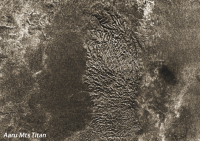
The recent http://photojournal.jpl.nasa.gov/target/Titan
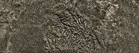
Planetary Photojournal images of Titans mountains (PIA 13330) are fascinating although well known to UMSF members. I was especially struck by the mountains north of Aaru when I first looked at the T16 radar swath! http://pirlwww.lpl.arizona.edu/~perry/RADAR/#T16 Although photojournal images are well done I thought one might tweak the raws some more to get a better idea of what these landforms look like. Below are 3 views done in photoshop elements using the northern most portion of PIA 13330. The last 3D image was created with a nice shareware program T3D-2D to 3D Image Converter from Cherry Cola Studios using the geometric and parallel 20 weight and shift of 1 reverse depth cue settings. (you'll have to cross your eyes and stare at the middle image until its clear to see the 3D effect !) These mountains seem highly eroded by fluvial processes. Some of the eroding rivers are still prominent, draining into the radar smooth plain to the north.
|
|||
|
|
|
|||
|
Aug 25 2010, 02:28 AM
Post
#81
|
|
|
Senior Member Group: Moderator Posts: 2785 Joined: 10-November 06 From: Pasadena, CA Member No.: 1345 |
Interesting how the channels go to the north into a local minimum, while the regional minimum is directly to the south.
In the images N is to the left, S is to the left. -------------------- Some higher resolution images available at my photostream: http://www.flickr.com/photos/31678681@N07/
|
|
|
|
|
Aug 25 2010, 07:08 AM
Post
#82
|
||
|
Member Group: Members Posts: 700 Joined: 1-April 08 From: Minnesota ! Member No.: 4081 |
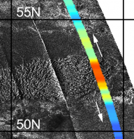
QUOTE (Juramike @ Aug 24 2010, 08:28 PM) Interesting how the channels go to the north into a local minimum, while the regional minimum is directly to the south. In the images N is to the left, S is to the left. ... Titan has strange topography but ... N is to the left and S is to the right  in the above figures. in the above figures.Drainage channels appear on either side of the mountains (see fig below) as one might anticipate if the region arose as a plateau and was eroded on both sides. Perhaps the northern facing side had greater fluvial erosion given its more northerly location and current polar atmospheric/weather patterns.
|
|
|
|
|
|
|
Aug 25 2010, 04:17 PM
Post
#83
|
|
|
Senior Member Group: Members Posts: 2998 Joined: 30-October 04 Member No.: 105 |
TR--
Nifty topography. Reminds me of an uplifted plateau that has been dissected. Think of the Grand Canyon area. Minor typo, though: From Post#80: (you'll have to cross your eyes and stare at the middle image until its clear to see the 3D effect !) Should read: (you'll have to cross your eyes and stare at the middle of the (third) image until its clear to see the 3D effect !) You'll go googley-eyed trying to get x-eyed stereo out of the middle image... --Bill -------------------- |
|
|
|
|
Aug 26 2010, 02:21 AM
Post
#84
|
|
|
Senior Member Group: Members Posts: 1276 Joined: 25-November 04 Member No.: 114 |
^ I tried to do the cross eyed thing and my result was a headache!
 Have you done a 3D image? |
|
|
|
|
Aug 26 2010, 08:51 AM
Post
#85
|
||
|
Member Group: Members Posts: 700 Joined: 1-April 08 From: Minnesota ! Member No.: 4081 |
I found this article via Wikipedia that may help you freeview the images and achieve a 3D image that is in focus. Try the example below as its fairly easy to do. The reference article is found here. http://www.angelfire.com/ca/erker/freeview.html
Learning to Cross Eye Freeview: In cross eye freeviewing the image for the left eye is on the right and the image for the right eye is on the left. You stare at a point about 1/2 way to the screen so that your eye's gaze is crossing at the half way point. Thus the left eye sees the correct image which is on the right. As you cross your eyes the image will go double. When your eyes are crossed the correct amount the middle images will overlap and be in 3d. The two outer images will remain and will be in 2d. Try to cross eye freeview view the image below. Hint: be sure to maximize the image window to remove distracting objects like the window border and background text etc.
|
|
|
|
|
|
|
Sep 1 2010, 05:43 AM
Post
#86
|
||
|
Member Group: Members Posts: 700 Joined: 1-April 08 From: Minnesota ! Member No.: 4081 |
Here is another 2D to 3D image that is relatively easy to obtain 3D effect with cross-eye free viewing. The 'Please Register' comment appears because I cannot find a way to purchase this shareware to register it!
The dissected elevated hills near the Huygens landing site as seen by the DISR are emphasized in this view. Both dendritic and rectangular drainage channel patterns are noted. A nice discussion of titan river drainage patterns appears here http://www.planetary.org/blog/article/00002542/
|
|
|
|
|
|
|
Sep 7 2010, 06:27 AM
Post
#87
|
|||
|
Member Group: Members Posts: 700 Joined: 1-April 08 From: Minnesota ! Member No.: 4081 |
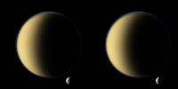
N00153307-9 composite with 2D to 3D conversion and Titan and Tethys below provide more examples to try the cross-eye stereoscopic view.
|
||
|
|
|
||
|
Sep 10 2010, 08:31 AM
Post
#88
|
|||
|
Member Group: Members Posts: 700 Joined: 1-April 08 From: Minnesota ! Member No.: 4081 |
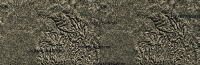
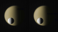
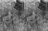
N Aaru Mountains, Titan. T16 SAR swath Part2, edited to remove artifacts.
Edit: Now with the 3D version (cross-eyed of course)
|
||
|
|
|
||
|
Dec 6 2010, 06:56 PM
Post
#89
|
||
|
Member Group: Members Posts: 700 Joined: 1-April 08 From: Minnesota ! Member No.: 4081 |
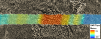
Things are a little slow with Titan at the moment! While waiting for the post T72 storm raws of Titan, I went to a favorite SAR of many of us and constructed a perspective-pseudo-3D version of part of T39. Shown below is a 'cross-eyes' stereo version. Not sure all the apparent topographic hi's and low's are real (have to check Mikes work again) but the area would be an amazing place to visit one day.
|
|
|
|
|
|
|
Dec 7 2010, 01:59 PM
Post
#90
|
|
 Member Group: Members Posts: 656 Joined: 20-April 05 From: League City, Texas Member No.: 285 |
QUOTE (titanicrivers @ Dec 6 2010, 12:56 PM) ...Not sure all the apparent topographic hi's and low's are real... The topography I see seems to relate nicely to the stream networks, though the horizontal ridge spanning the center left of the image may be questionable. I'd enjoy seeing lots more cross-eyed like this, or even entire radar swaths
|
|
|
|
|

|
Lo-Fi Version | Time is now: 1st June 2024 - 09:21 PM |
|
RULES AND GUIDELINES Please read the Forum Rules and Guidelines before posting. IMAGE COPYRIGHT |
OPINIONS AND MODERATION Opinions expressed on UnmannedSpaceflight.com are those of the individual posters and do not necessarily reflect the opinions of UnmannedSpaceflight.com or The Planetary Society. The all-volunteer UnmannedSpaceflight.com moderation team is wholly independent of The Planetary Society. The Planetary Society has no influence over decisions made by the UnmannedSpaceflight.com moderators. |
SUPPORT THE FORUM Unmannedspaceflight.com is funded by the Planetary Society. Please consider supporting our work and many other projects by donating to the Society or becoming a member. |
|