New mosaic map of Itokawa |

  |
New mosaic map of Itokawa |
 Sep 17 2010, 03:24 PM Sep 17 2010, 03:24 PM
Post
#16
|
|
|
Solar System Cartographer  Group: Members Posts: 10229 Joined: 5-April 05 From: Canada Member No.: 227 |
Yes, you could walk (float) around the blasted think a lot faster than you can map it! 3 days working on one image...
Phil -------------------- ... because the Solar System ain't gonna map itself.
Also to be found posting similar content on https://mastodon.social/@PhilStooke Maps for download (free PDF: https://upload.wikimedia.org/wikipedia/comm...Cartography.pdf NOTE: everything created by me which I post on UMSF is considered to be in the public domain (NOT CC, public domain) |
 |
 
|
|
Sep 17 2010, 07:48 PM
Post
#17
|
||
|
Member Group: Members Posts: 140 Joined: 20-November 07 Member No.: 3967 |
Itokawa on Wembley, at least from my point of view, looks like this:
An outline of the solid body is at upper right; the other shape, of course, is the asteroid's unfolded surface, using a finely branched system of ridges as the map boundary.
Attached thumbnail(s)
|
|
|
|
|
|
|
Sep 17 2010, 07:54 PM
Post
#18
|
|
|
Founder Group: Chairman Posts: 14434 Joined: 8-February 04 Member No.: 1 |
Personally, I think the addition of an asteroid is a drastic improvement.
|
|
|
|
|
Sep 23 2010, 09:09 PM
Post
#19
|
||
|
Solar System Cartographer Group: Members Posts: 10229 Joined: 5-April 05 From: Canada Member No.: 227 |
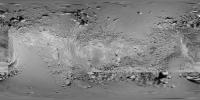
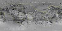
Here's an update to the Itokawa mosaic. I have added several images to the area on and north of the equator and around the 180 longitude region (middle of this map). The southern edge of that region will be next. Slow going, but it will gradually fill in. There will still be some further improvements to parts already done.
Phil
-------------------- ... because the Solar System ain't gonna map itself.
Also to be found posting similar content on https://mastodon.social/@PhilStooke Maps for download (free PDF: https://upload.wikimedia.org/wikipedia/comm...Cartography.pdf NOTE: everything created by me which I post on UMSF is considered to be in the public domain (NOT CC, public domain) |
|
|
|
|
|
|
Sep 23 2010, 09:28 PM
Post
#20
|
|
|
Member Group: Members Posts: 140 Joined: 20-November 07 Member No.: 3967 |
Wow! That is a fine piece of work, Phil.
But, to digress, I'm finding a few discrepancies in the plastic model that JAXA made for me, and the location of various features (three prominent rocks, so not very many places) in your earlier map. One reason is that had to draw lat/longs on the model by hand and eye, so my constant-scale natural boundary map, we should expect, is not perfectly aligned with the lat/longs of features on the cylindrical map. But the curious thing is that the discrepancy is an almost perfect 10 degrees. I'll post a map later with the misalignments called out, but is it possible that there might be some projection anomalies, let's call them, in your initial projection? |
|
|
|
|
Sep 23 2010, 10:11 PM
Post
#21
|
|
|
Solar System Cartographer Group: Members Posts: 10229 Joined: 5-April 05 From: Canada Member No.: 227 |
Yes, let's have a look at the discrepancies. The relief distortions on Itokawa are more extreme than almost anywhere else. There might be problems at any stage in the development of this map from Bob Gaskell's shape through the alignment of the grid and on to the reprojection and mosaicking itself. So let me see what the problems are, and maybe I can sort them out. I still have improvements to make to my new mosaic, which might possibly correct the problems you're talking about.
Phil -------------------- ... because the Solar System ain't gonna map itself.
Also to be found posting similar content on https://mastodon.social/@PhilStooke Maps for download (free PDF: https://upload.wikimedia.org/wikipedia/comm...Cartography.pdf NOTE: everything created by me which I post on UMSF is considered to be in the public domain (NOT CC, public domain) |
|
|
|
|
Sep 25 2010, 06:05 PM
Post
#22
|
||
|
Member Group: Members Posts: 140 Joined: 20-November 07 Member No.: 3967 |
QUOTE (elakdawalla @ Sep 9 2010, 11:29 AM)  Yaaaay Phil! I can't wait to see this come together. After I assembled Chuck Clark's cut-and-assemble model, I tried to identify the named features on it but made almost no headway at all; it was too hard to figure out what was being named on the photo map, even using the stuff from the USGS nomenclature page and map. I hope it'll be easier to figure things out with your maps. The large smooth area on this image is Sagamihara regio, right? Here is Phil's first cylindrical map with the USGS features named (craters are marked with a triangle; regios are just generally labeled for the moment because drawing their boundaries is iffy from the pictures. But there appears to be a discrepancy in the nomenclature lat/longs for Miyabaru. USGS lists it at -40;244, which puts it in the southern hemisphere, and roughly along the short axis. But by the picture Emily links to (and also the 2009 Icarus article Figure 4) Miyabaru is definitely on the so-called head, and in the northern hemisphere. So on the map I've placed it at a depression at roughly +10 lat; 13 long. Phil, I'll post the rock location discrepancies here shortly. Patience. Oh, and there's more, now that I double check the regio lat/longs list. I placed these based on the pics, not the lat/longs in USGS. Arcoona is way off. It's the tail end of the otter (and I have a plastic model, so easy to locate it by eye); it can't possibly be where USGS says it is (+28; 202). The listing for LINEAR regio is at best at the extreme southern edge based on the pics. The listing for Ohsumi regio is at best at the extreme northwestern edge based on the pics. The listing for Yoshinobu regio appears to be way way off. By the pics, Yoshinobu is the humpback on the neck, i.e. northern hemisphere around the zero longitude. USGS's point is on the belly. The listing for Uchinoura regio synchronizes with the pics. MUSES-C and Sagamihara are so extensive the listed centerpoints are not much help in defining the regions. I wonder if I'm misreading or misunderstanding the USGS nomenclature chart, but then, the small features (craters) all plot out on target with my plastic model and Phil's map. So, Emily, perhaps it's no wonder you couldn't make much headway.
Attached thumbnail(s)
|
|
|
|
|
|
|
Sep 25 2010, 08:41 PM
Post
#23
|
|
 Administrator Group: Admin Posts: 5172 Joined: 4-August 05 From: Pasadena, CA, USA, Earth Member No.: 454 |
Thanks for labeling those, Chuck, and I feel much better!
-------------------- My website - My Patreon - @elakdawalla on Twitter - Please support unmannedspaceflight.com by donating here.
|
|
|
|
|
Sep 25 2010, 10:08 PM
Post
#24
|
|
|
Member Group: Members Posts: 140 Joined: 20-November 07 Member No.: 3967 |
happy to be of help.
|
|
|
|
|
Sep 28 2010, 03:11 PM
Post
#25
|
||
|
Member Group: Members Posts: 140 Joined: 20-November 07 Member No.: 3967 |
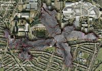
Oh, by the way, here's how Itokawa scales onto The National Mall.
A float around the asteroid the equivalent of, let's say, an half-day tour of the various Smithsonians; Itokawa's long dimension a loose fit betwixt the Lincoln and Second World War memorials.
Attached thumbnail(s)
|
|
|
|
|
|
|
Sep 28 2010, 07:41 PM
Post
#26
|
||
|
Member Group: Members Posts: 140 Joined: 20-November 07 Member No.: 3967 |
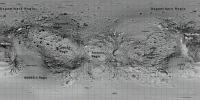
Here is the (old) cylindrical map showing regio boundaries.
Arcoona Regio shows both the outline from Emily's link (shown in solid line), and the outline from Icarus 2009 (shown dashed), which is bit larger. Neither from the pics nor the link could I find complete boundaries for Sagamihara Regio or MUSES-C Regio; solid line shows the boundary from the link, dashed line shows my guess at closure.
Attached thumbnail(s)
|
|
|
|
|
|
|
Sep 2 2011, 05:25 PM
Post
#27
|
||
|
Solar System Cartographer Group: Members Posts: 10229 Joined: 5-April 05 From: Canada Member No.: 227 |
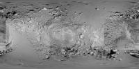
After a year-long hiatus I have returned to the Itokawa mosaic. I have finished two of the three equatorial sections, leaving the hardest part until the last - the head of our cute little otter asteroid. Hardest because the distortions will be most extreme in this area. Here is what I have so far, reduced scale and heavily compressed. The final product will eventually end up in the PDS Small Bodies Node.
Phil
PS one area here looks a bit sketchy - just under the middle of the image. It was never seen well, always on the terminator and/or near the limb. Best I can do right now. -------------------- ... because the Solar System ain't gonna map itself.
Also to be found posting similar content on https://mastodon.social/@PhilStooke Maps for download (free PDF: https://upload.wikimedia.org/wikipedia/comm...Cartography.pdf NOTE: everything created by me which I post on UMSF is considered to be in the public domain (NOT CC, public domain) |
|
|
|
|
|
|
Sep 2 2011, 06:13 PM
Post
#28
|
|
|
Member Group: Members Posts: 140 Joined: 20-November 07 Member No.: 3967 |
[quote name='Phil Stooke' date='Sep 2 2011, 01:25 PM' post='178269']
After a year-long hiatus Go Phil! |
|
|
|
|
Sep 8 2011, 09:17 PM
Post
#29
|
||
|
Solar System Cartographer Group: Members Posts: 10229 Joined: 5-April 05 From: Canada Member No.: 227 |
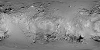
Current version of the mosaic - the worst remaining gap is at left and right edges south of the equator, but a few other issues remain as well.
Phil
-------------------- ... because the Solar System ain't gonna map itself.
Also to be found posting similar content on https://mastodon.social/@PhilStooke Maps for download (free PDF: https://upload.wikimedia.org/wikipedia/comm...Cartography.pdf NOTE: everything created by me which I post on UMSF is considered to be in the public domain (NOT CC, public domain) |
|
|
|
|
|
|
Oct 11 2011, 07:48 PM
Post
#30
|
||
|
Solar System Cartographer Group: Members Posts: 10229 Joined: 5-April 05 From: Canada Member No.: 227 |
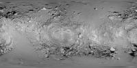
The global photomosaic map of Itokawa is almost finished. It looks like this now:
Just a few cosmetic improvements still to do... but they will have to wait as I must return to Mars. Phil -------------------- ... because the Solar System ain't gonna map itself.
Also to be found posting similar content on https://mastodon.social/@PhilStooke Maps for download (free PDF: https://upload.wikimedia.org/wikipedia/comm...Cartography.pdf NOTE: everything created by me which I post on UMSF is considered to be in the public domain (NOT CC, public domain) |
|
|
|
|
|
|

|
Lo-Fi Version | Time is now: 26th September 2024 - 11:23 AM |
|
RULES AND GUIDELINES Please read the Forum Rules and Guidelines before posting. IMAGE COPYRIGHT |
OPINIONS AND MODERATION Opinions expressed on UnmannedSpaceflight.com are those of the individual posters and do not necessarily reflect the opinions of UnmannedSpaceflight.com or The Planetary Society. The all-volunteer UnmannedSpaceflight.com moderation team is wholly independent of The Planetary Society. The Planetary Society has no influence over decisions made by the UnmannedSpaceflight.com moderators. |
SUPPORT THE FORUM Unmannedspaceflight.com is funded by the Planetary Society. Please consider supporting our work and many other projects by donating to the Society or becoming a member. |
|