On to Santa Maria! |

  |
On to Santa Maria! |
 Dec 3 2010, 05:10 PM Dec 3 2010, 05:10 PM
Post
#331
|
||
 The Poet Dude  Group: Moderator Posts: 5551 Joined: 15-March 04 From: Kendal, Cumbria, UK Member No.: 60 |
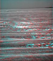
In super-sensational 3D - sorry, I thought I was writing for the SKY TV magazine for a moment there - you really get a feel for how Santa Maria is hidden by a drop in the local terrain...
Another couple of drives and we should see her a lot better, I'd say. -------------------- |
|
 |
 
|
|
|
Dec 3 2010, 05:29 PM
Post
#332
|
|
|
Senior Member Group: Members Posts: 3516 Joined: 4-November 05 From: North Wales Member No.: 542 |
Very nice! I'm trying to decide whether the near horizon is in fact the patch of outcrop running across our path about 70m ahead, with the little crater Tesh mentioned out of sight beyond it?? If so, it's over the top next drive. If it's not, and fredk's right about the little crater, then where is the outcrop that ought to be in front of it?
|
|
|
|
|
Dec 3 2010, 06:14 PM
Post
#333
|
|
 Director of Galilean Photography Group: Members Posts: 896 Joined: 15-July 04 From: Austin, TX Member No.: 93 |
Endurance did show a bit of cliff at the equivalent distance. Which, btw, was Eagle Crater! Another drive or two, and we will be closer to Santa Maria than Opportunity was to Endurance on Sol 1.
Lion King pan right outside Eagle: http://photojournal.jpl.nasa.gov/jpeg/PIA05755.jpg -------------------- Space Enthusiast Richard Hendricks
-- "The engineers, as usual, made a tremendous fuss. Again as usual, they did the job in half the time they had dismissed as being absolutely impossible." --Rescue Party, Arthur C Clarke Mother Nature is the final inspector of all quality. |
|
|
|
|
Dec 3 2010, 06:21 PM
Post
#334
|
||
|
Junior Member Group: Members Posts: 41 Joined: 27-May 09 From: Burgundy Member No.: 4798 |
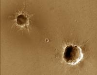
What we saw of Endurance at approximately the same distance :
Really different EDIT : Sorry same idea but too late! |
|
|
|
|
|
|
Dec 3 2010, 11:13 PM
Post
#335
|
|
 Senior Member Group: Members Posts: 1432 Joined: 26-July 08 Member No.: 4270 |
Latest on Opportunity from Scott Maxwell's titter. "Oh, my, nearly four hours of drive time thisol -- longer than I thought. We might make it the full 140m after all!"
-------------------- -- Hungry4info (Sirius_Alpha)
|
|
|
|
|
Dec 4 2010, 05:29 AM
Post
#336
|
|
 Senior Member Group: Members Posts: 4247 Joined: 17-January 05 Member No.: 152 |
And also some new crater names from here:
QUOTE Also doing mid-drive imaging of crater triplet ("Vanguard"), and post-drive imaging should cover Voskhod Crater.
|
|
|
|
|
Dec 4 2010, 11:43 AM
Post
#337
|
|||
|
The Poet Dude Group: Moderator Posts: 5551 Joined: 15-March 04 From: Kendal, Cumbria, UK Member No.: 60 |
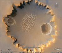
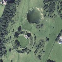
Continuing our series of "How big is it compared to...?", here you can see Santa Maria (left), Eagle Crater (centre) and Endurance (right) all to the same scale...
... and also Santa Maria and Endurance magically transported to the interior of Victoria Crater...
-------------------- |
||
|
|
|
||
|
Dec 4 2010, 04:36 PM
Post
#338
|
|||
|
Senior Member Group: Members Posts: 4247 Joined: 17-January 05 Member No.: 152 |
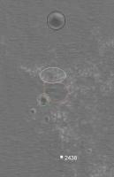
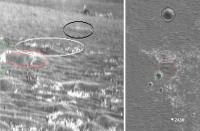
QUOTE (ngunn @ Dec 3 2010, 05:29 PM)  I'm trying to decide whether the near horizon is in fact the patch of outcrop running across our path about 70m ahead... Here are my identifications, using mhoward's 2438 pancam mosaic. Green is a bit of one of the crater triplet (Vanguard?) and black is the 15m crater (Voskhod?). (You can see the rest of the triplet in the neighbouring pancam frame.) I think white is the patch of outcrop you asked about.
If we do 140 metres, we should be very close to Voskhod! |
||
|
|
|
||
|
Dec 4 2010, 05:14 PM
Post
#339
|
||
|
Solar System Cartographer Group: Members Posts: 10172 Joined: 5-April 05 From: Canada Member No.: 227 |
Now Fred! You know there's only one way to do this kind of comparison!
(please forgive the cheeky filename!) So your pink circle is really one of the craters, but the black circle is correct. Phil -------------------- ... because the Solar System ain't gonna map itself.
Also to be found posting similar content on https://mastodon.social/@PhilStooke Maps for download (free PD: https://upload.wikimedia.org/wikipedia/comm...Cartography.pdf NOTE: everything created by me which I post on UMSF is considered to be in the public domain (NOT CC, public domain) |
|
|
|
|
|
|
Dec 4 2010, 06:25 PM
Post
#340
|
||
 Senior Member Group: Admin Posts: 4763 Joined: 15-March 05 From: Glendale, AZ Member No.: 197 |
QUOTE (Stu @ Dec 4 2010, 03:43 AM) Continuing our series of "How big is it compared to...?", Here's one just for you Stu.
Attached thumbnail(s)
-------------------- If Occam had heard my theory, things would be very different now.
|
|
|
|
|
|
|
Dec 4 2010, 06:40 PM
Post
#341
|
|
|
The Poet Dude Group: Moderator Posts: 5551 Joined: 15-March 04 From: Kendal, Cumbria, UK Member No.: 60 |
Dan... wow... thank you! That is (bleep) brilliant!!!
Edit: thanks, Dan! http://roadtoendeavour.wordpress.com/2010/...-of-santa-maria -------------------- |
|
|
|
|
Dec 4 2010, 06:41 PM
Post
#342
|
||
 Senior Member Group: Members Posts: 1089 Joined: 19-February 05 From: Close to Meudon Observatory in France Member No.: 172 |
QUOTE (fredk @ Dec 4 2010, 05:36 PM) Here are my identifications, using mhoward's 2438 pancam mosaic. Green is a bit of one of the crater triplet (Vanguard?) and black is the 15m crater (Voskhod?). (You can see the rest of the triplet in the neighbouring pancam frame.) I think white is the patch of outcrop you asked about.  When I see your images, I feel like Santa Maria is our last stop at a big geology feature before we rush for the next 6 km to Cape York at Endeavour Crater... Our "last chance" science (and beer) saloon ! When I see your images, I feel like Santa Maria is our last stop at a big geology feature before we rush for the next 6 km to Cape York at Endeavour Crater... Our "last chance" science (and beer) saloon ! 
|
|
|
|
|
|
|
Dec 4 2010, 07:01 PM
Post
#343
|
|
|
Solar System Cartographer Group: Members Posts: 10172 Joined: 5-April 05 From: Canada Member No.: 227 |
That was indeed brilliant, Dan. Truly inspired.
Phil -------------------- ... because the Solar System ain't gonna map itself.
Also to be found posting similar content on https://mastodon.social/@PhilStooke Maps for download (free PD: https://upload.wikimedia.org/wikipedia/comm...Cartography.pdf NOTE: everything created by me which I post on UMSF is considered to be in the public domain (NOT CC, public domain) |
|
|
|
|
Dec 4 2010, 08:10 PM
Post
#344
|
||
|
Senior Member Group: Members Posts: 4247 Joined: 17-January 05 Member No.: 152 |
QUOTE (Phil Stooke @ Dec 4 2010, 05:14 PM) So your pink circle is really one of the craters, but the black circle is correct. Agreed. Phil-o-vision saves the day! Here's my corrected version:
(And the filename is perfect - I've been fighting reality for a long time now! )
|
|
|
|
|
|
|
Dec 4 2010, 09:31 PM
Post
#345
|
|
|
Senior Member Group: Members Posts: 3516 Joined: 4-November 05 From: North Wales Member No.: 542 |
Thanks Fred and Phil for that excellent key to the view ahead. All that's missing is the distance to that near horizon. It seems devoid of features that would make it easy to triangulate. Also it seems to retreat as we advance, as does tend to happen on convex surfaces. All the same there must come a point where convex gives way to concave and all the intervening ground is revealed. Maybe not for another fortnight - or maybe even tomorrow.
|
|
|
|
|

|
Lo-Fi Version | Time is now: 30th May 2024 - 06:01 AM |
|
RULES AND GUIDELINES Please read the Forum Rules and Guidelines before posting. IMAGE COPYRIGHT |
OPINIONS AND MODERATION Opinions expressed on UnmannedSpaceflight.com are those of the individual posters and do not necessarily reflect the opinions of UnmannedSpaceflight.com or The Planetary Society. The all-volunteer UnmannedSpaceflight.com moderation team is wholly independent of The Planetary Society. The Planetary Society has no influence over decisions made by the UnmannedSpaceflight.com moderators. |
SUPPORT THE FORUM Unmannedspaceflight.com is funded by the Planetary Society. Please consider supporting our work and many other projects by donating to the Society or becoming a member. |
|