Opportunity Route Map |

  |
Opportunity Route Map |
 Jan 4 2011, 04:06 PM Jan 4 2011, 04:06 PM
Post
#2926
|
|
|
Senior Member  Group: Moderator Posts: 4279 Joined: 19-April 05 From: .br at .es Member No.: 253 |
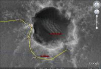
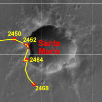
New Year got me somehow delayed on the route map updates. Here's the latest one, after sol 2468 drive.
  Route_Map_Sol2468.kml ( 72.29K )
Number of downloads: 608
Route_Map_Sol2468.kml ( 72.29K )
Number of downloads: 608 |
 |
 
|
|
Jan 4 2011, 05:10 PM
Post
#2927
|
|
|
Senior Member Group: Members Posts: 2922 Joined: 14-February 06 From: Very close to the Pyrénées Mountains (France) Member No.: 682 |
Looking at Doug's post regarding Oppy from above on Dec 31st 2010, I can see you were still right till then.
Happy New Route Eduardo! -------------------- |
|
|
|
|
Jan 5 2011, 12:26 AM
Post
#2928
|
|
|
Solar System Cartographer Group: Members Posts: 10184 Joined: 5-April 05 From: Canada Member No.: 227 |
2-4-6-8 - who do we appreciate? Eduardo!
Phil -------------------- ... because the Solar System ain't gonna map itself.
Also to be found posting similar content on https://mastodon.social/@PhilStooke Maps for download (free PD: https://upload.wikimedia.org/wikipedia/comm...Cartography.pdf NOTE: everything created by me which I post on UMSF is considered to be in the public domain (NOT CC, public domain) |
|
|
|
|
Jan 5 2011, 06:45 PM
Post
#2929
|
|
 Junior Member Group: Members Posts: 39 Joined: 19-August 09 From: Dallas Member No.: 4905 |
Looks to me that after sol 2468 drive Opportunity could have surpassed total distance traveled by Apollo 16 Lunar Rover (LRV16)
LRV16 26.55 km 16.5 mi Sol 2464 26.51 km 16.47 mi Opportunity only needed 40 meters to accomplish that, and looks like drive on sol 2468 was little more (?) than that. |
|
|
|
|
Jan 5 2011, 07:55 PM
Post
#2930
|
|
 Senior Member Group: Moderator Posts: 2262 Joined: 9-February 04 From: Melbourne - Oz Member No.: 16 |
Yeah, Scott tweeted that Oppy had passed that milestone a couple of days ago.
-------------------- |
|
|
|
|
Jan 5 2011, 08:45 PM
Post
#2931
|
|
|
Junior Member Group: Members Posts: 39 Joined: 19-August 09 From: Dallas Member No.: 4905 |
QUOTE (jamescanvin @ Jan 5 2011, 01:55 PM)  Yeah, Scott tweeted that Oppy had passed that milestone a couple of days ago. I missed that somehow even though I have RSS feed of his Tweets. Perhaps Tesheiner could put some sort of marker on his route map .... |
|
|
|
|
Jan 9 2011, 02:18 PM
Post
#2932
|
||
|
Senior Member Group: Moderator Posts: 4279 Joined: 19-April 05 From: .br at .es Member No.: 253 |
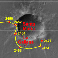
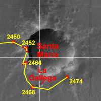
Here's Opportunity's position after sol 2474.
Route_Map_Sol2474.kml ( 72.67K )
Number of downloads: 518 |
|
|
|
|
|
|
Jan 12 2011, 08:03 PM
Post
#2933
|
|
|
Senior Member Group: Moderator Posts: 4279 Joined: 19-April 05 From: .br at .es Member No.: 253 |
|
|
|
|
|
Feb 3 2011, 08:11 PM
Post
#2934
|
|
|
Senior Member Group: Moderator Posts: 2262 Joined: 9-February 04 From: Melbourne - Oz Member No.: 16 |
I'm a few hours early but as I'm busy tomorrow and over the weekend I'll post this now:
Sol 2500  
-------------------- |
|
|
|
|
Feb 4 2011, 05:58 AM
Post
#2935
|
|
 Senior Member Group: Members Posts: 2228 Joined: 1-December 04 From: Marble Falls, Texas, USA Member No.: 116 |
Very nice, James. Your map with 100 sol increments really puts the journey into perspective.

-------------------- ...Tom
I'm not a Space Fan, I'm a Space Exploration Enthusiast. |
|
|
|
|
Feb 7 2011, 01:51 PM
Post
#2936
|
|
 Member Group: Members Posts: 562 Joined: 29-March 05 Member No.: 221 |
Opportunity's total odometry must be approaching the 'as the crow flies' distance to Endeavour from the landing site.
|
|
|
|
|
Feb 8 2011, 12:15 AM
Post
#2937
|
|
|
Junior Member Group: Members Posts: 71 Joined: 19-January 10 From: Grimsby, N.E. Lincs, UK Member No.: 5179 |
QUOTE (paxdan @ Feb 7 2011, 01:51 PM) must be approaching the 'as the crow flies' distance to Endeavour Paxdan, I'll have first dig at this (but I suspect guys like Climber and the other regular posters on the statistical threads will be able to give you a better answer) but I think the point you mention was passed by Oppy a long time ago. By looking at the map put up a couple of posts ago (and thank you to James Canvin for them) I would estimate that Cape York is approximately 20kms from the landing site whereas she has travelled well over 26kms. Neil |
|
|
|
| Guest_Oersted_* |
Feb 8 2011, 08:56 AM
Post
#2938
|
|
Guests |
And, well, 26 km. is counted in straight-line increments. When we count all the little squiggles in between (looking at odometry) we probably get a figure which is a good deal bigger. Minus the turning-in-place-bits of Jammerbugt and elsewhere.
|
|
|
|
|
Feb 8 2011, 03:04 PM
Post
#2939
|
|
 Senior Member Group: Members Posts: 4251 Joined: 17-January 05 Member No.: 152 |
But 26+ km is the odometry. So it should include all of the little movements, no?
|
|
|
|
|
Feb 24 2011, 02:17 PM
Post
#2940
|
|
|
Senior Member Group: Moderator Posts: 4279 Joined: 19-April 05 From: .br at .es Member No.: 253 |
I think it's time to start updating the route map once again.
Here it is, up to sol 2519 (thisol), and the corresponding KML file for Google Earth. Take a close look to the GE version because you will find a new layer named "Opportunity Calendar Dates" made by Emily Lakdawalla and containing placemarks for the first day of every quarter since the rover left Victoria. It should be enough to figure out roughly when on Earth's calendar Opportunity was at any given location on the map. 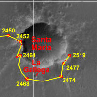 Route_Map_Sol2519.kml ( 73.78K )
Number of downloads: 625
Route_Map_Sol2519.kml ( 73.78K )
Number of downloads: 625 |
|
|
|
|

|
Lo-Fi Version | Time is now: 5th June 2024 - 06:51 AM |
|
RULES AND GUIDELINES Please read the Forum Rules and Guidelines before posting. IMAGE COPYRIGHT |
OPINIONS AND MODERATION Opinions expressed on UnmannedSpaceflight.com are those of the individual posters and do not necessarily reflect the opinions of UnmannedSpaceflight.com or The Planetary Society. The all-volunteer UnmannedSpaceflight.com moderation team is wholly independent of The Planetary Society. The Planetary Society has no influence over decisions made by the UnmannedSpaceflight.com moderators. |
SUPPORT THE FORUM Unmannedspaceflight.com is funded by the Planetary Society. Please consider supporting our work and many other projects by donating to the Society or becoming a member. |
|