Geomorphology of Cape York and Solander Point, Examining Opportunity's destination at Endeavour Crater |

  |
Geomorphology of Cape York and Solander Point, Examining Opportunity's destination at Endeavour Crater |
 Feb 13 2011, 08:37 AM Feb 13 2011, 08:37 AM
Post
#61
|
|
 Senior Member  Group: Members Posts: 2228 Joined: 1-December 04 From: Marble Falls, Texas, USA Member No.: 116 |
That's right, Stu. The profiles in pgridrods's first image in his post above show it very nicely, even if the vertical and horizontal scales are not identical. Those profiles are essentially showing that Opportunity will not really need to climb up to get on top of Cape York. The idea to take away from this whole discussion is that Opportunity should be able to drive right over the top of Cape York with little trouble, unless boulders or loose sand block the way. The steepest slopes are on the back side of the Cape, and those apparently average 7-9 degrees.
Regarding the hills to the south, his topo maps posted above and earlier in another thread show them to have much more significant topography. -------------------- ...Tom
I'm not a Space Fan, I'm a Space Exploration Enthusiast. |
 |
 
|
|
Feb 13 2011, 08:43 AM
Post
#62
|
||||
 The Poet Dude Group: Moderator Posts: 5551 Joined: 15-March 04 From: Kendal, Cumbria, UK Member No.: 60 |
Thanks cosmic; I had read those posts... I was just recapping whilst virtually banging my head against my computer screen!
 I've just been
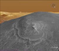
When you look at it more closely it looks like material flowed and rolled over Cape York from the west, doesn't it..?
-------------------- |
|||
|
|
|
|||
|
Feb 13 2011, 09:55 AM
Post
#63
|
|
|
Senior Member Group: Members Posts: 1057 Joined: 17-February 09 Member No.: 4605 |
Stu. I see what you mean. The NW rim has been eroded flat and the Meridiani sulphate sediments have flowed into the crater. Flowed tends to imply fluvial action but that terrace around Cape York does remind me of a shallow shoreline, sandbar rip channel system. Vikingmars "Dagger Valley" at the North end fits that scenario as a rip outflow channel. Cape York may be topography challenged but it is a fascinating destination.
|
|
|
|
|
Feb 13 2011, 12:46 PM
Post
#64
|
|
|
Senior Member Group: Members Posts: 3516 Joined: 4-November 05 From: North Wales Member No.: 542 |
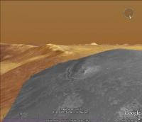
Stu - or anyone handy with Google Mars - can you identify the hills on the horizon behind Cape York in your two lower views?
|
|
|
|
|
Feb 13 2011, 01:40 PM
Post
#65
|
||
|
The Poet Dude Group: Moderator Posts: 5551 Joined: 15-March 04 From: Kendal, Cumbria, UK Member No.: 60 |
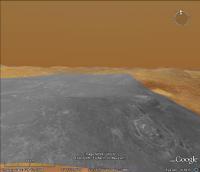
Wider angle view...
Remember, tho, that everything is vertically stretched x3 -------------------- |
|
|
|
|
|
|
Feb 13 2011, 05:20 PM
Post
#66
|
|
|
Senior Member Group: Members Posts: 2228 Joined: 1-December 04 From: Marble Falls, Texas, USA Member No.: 116 |
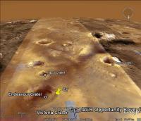
You have to be very careful when looking at elevations using Google Mars. As I and others have pointed out, most of the topographic information used in Google mars is based on the MOLA coverage, which is not uniform, and typically not very closely spaced. Large stretches of Endeavor's rim were not sampled at all by MOLA shot points, so elevation maps derived from them do not display accurate elevations where topography is changing rapidly between MOLA lines and sample points. Emily posted a very nice kml file that will display those shot points in Google Mars. I think it was in the Distant Vistas thread.
One area of Mars that has higher frequency elevation coverage in Google Mars is Victoria Crater. That area has been populated with a digital elevation model based on more closely sampled points, probably based on a HiRise stereo pair. If you look at Victoria Crater in Google Mars you will see much more topographic detail than most anywhere else. -------------------- ...Tom
I'm not a Space Fan, I'm a Space Exploration Enthusiast. |
|
|
|
|
Feb 13 2011, 05:24 PM
Post
#67
|
|
|
The Poet Dude Group: Moderator Posts: 5551 Joined: 15-March 04 From: Kendal, Cumbria, UK Member No.: 60 |
Oh I agree, absolutely. I don't rely on GM, good as it is, for anything. But it is useful for giving a 'general impression' I'm sure you'll agree.
-------------------- |
|
|
|
|
Feb 13 2011, 06:09 PM
Post
#68
|
|
|
Senior Member Group: Members Posts: 3516 Joined: 4-November 05 From: North Wales Member No.: 542 |
QUOTE (Stu @ Feb 13 2011, 01:40 PM)  Wider angle view... Thanks. So, am I right in thinking that's part of the Miyamoto rim in the background? (Sorry, OT I know.) |
|
|
|
|
Feb 14 2011, 03:28 AM
Post
#69
|
|
 Administrator Group: Admin Posts: 5172 Joined: 4-August 05 From: Pasadena, CA, USA, Earth Member No.: 454 |
I'd like to remind those of you engaging in this discussion of this post in which I brought all of the available MOLA ground tracks into Google Mars. You can see that all the ground tracks completely miss the entire western rim of Endeavour, so the MOLA data simply doesn't record the elevation of the rim. It's not in the data at all. It would be a much more productive exercise to do photoclinometry or develop a DEM from stereo imaging, as pgrindrod is trying to do...
-------------------- My website - My Patreon - @elakdawalla on Twitter - Please support unmannedspaceflight.com by donating here.
|
|
|
|
|
Feb 14 2011, 06:40 AM
Post
#70
|
|
|
The Poet Dude Group: Moderator Posts: 5551 Joined: 15-March 04 From: Kendal, Cumbria, UK Member No.: 60 |
Oh, heck, we were just having a bit of fun speculating.
But ok, I'll go tidy my room... 
-------------------- |
|
|
|
|
Feb 14 2011, 06:49 AM
Post
#71
|
|
 Senior Member Group: Admin Posts: 4763 Joined: 15-March 05 From: Glendale, AZ Member No.: 197 |
QUOTE (Stu @ Feb 13 2011, 10:40 PM) But ok, I'll go tidy my room... ... and while you are up there write out 100 times THERE IS NO MOLA DATA FOR THE RIM OF ENDEAVOR CRATER or there'll be no wandering around that castle of yours in the dark this evening, young man. -------------------- If Occam had heard my theory, things would be very different now.
|
|
|
|
|
Feb 15 2011, 05:30 PM
Post
#72
|
||
|
Junior Member Group: Members Posts: 59 Joined: 18-July 07 From: London, UK Member No.: 2873 |
Just to add to the ways of getting across the geomorphology of Cape York, here's a red-blue analglyph of my Cape York DEM (plus contours).
And just in case that isn't overkill, here's a movie of the same area. You Tube animation - Cape York As you can tell, the resolution is turned way down in that movie (still managed to crash my computer several times!), and I don't yet have my pilot's licence. If my computer doesn't melt, expect a flurry of these things. Pete |
|
|
|
|
|
|
Feb 16 2011, 08:00 AM
Post
#73
|
|
|
Senior Member Group: Members Posts: 2228 Joined: 1-December 04 From: Marble Falls, Texas, USA Member No.: 116 |
Nice, Pete; but I think you got the red and cyan layers reversed. We can put our glasses on backwards to make it work, but if you are going to crank out a flurry of these things it might be best to reverse the colors.
 Thanks for all the good work, by the way. Thanks for all the good work, by the way. The animation was very effective.
-------------------- ...Tom
I'm not a Space Fan, I'm a Space Exploration Enthusiast. |
|
|
|
|
Feb 16 2011, 05:30 PM
Post
#74
|
|
 Senior Member Group: Moderator Posts: 3431 Joined: 11-August 04 From: USA Member No.: 98 |
Excellent movie and anaglyph. But yes, the red and cyan layers need to be reversed, or we need to wear our glasses upside-down.
|
|
|
|
|
Feb 16 2011, 07:59 PM
Post
#75
|
||
|
Member Group: Members Posts: 111 Joined: 14-March 05 From: Vastitas Borealis Member No.: 193 |
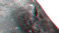
While we have seen very nice DEMs and a couple of lower-res anaglyphs of Cape York, I just thought an anaglyph in original size would be interesting for comparison. Only the north part was able to be included here within the maximum upload size, however I hope it's worth it.
Attached thumbnail(s)
|
|
|
|
|
|
|

|
Lo-Fi Version | Time is now: 24th September 2024 - 05:58 PM |
|
RULES AND GUIDELINES Please read the Forum Rules and Guidelines before posting. IMAGE COPYRIGHT |
OPINIONS AND MODERATION Opinions expressed on UnmannedSpaceflight.com are those of the individual posters and do not necessarily reflect the opinions of UnmannedSpaceflight.com or The Planetary Society. The all-volunteer UnmannedSpaceflight.com moderation team is wholly independent of The Planetary Society. The Planetary Society has no influence over decisions made by the UnmannedSpaceflight.com moderators. |
SUPPORT THE FORUM Unmannedspaceflight.com is funded by the Planetary Society. Please consider supporting our work and many other projects by donating to the Society or becoming a member. |
|